
Recommended
More Related Content
What's hot
What's hot (20)
Similar to Estuarine fisheries resource of India By B.pptx
Similar to Estuarine fisheries resource of India By B.pptx (20)
More from B. BHASKAR
More from B. BHASKAR (20)
Recently uploaded
Recently uploaded (20)
Estuarine fisheries resource of India By B.pptx
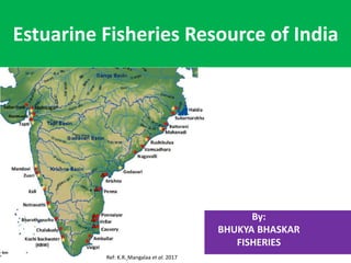
- 1. Estuarine Fisheries Resource of India By: BHUKYA BHASKAR FISHERIES Ref: K.R. Mangalaa et al. 2017
- 2. Introduction • India is a South Asian country situated between the Himalayas in the north and the Indian Ocean in the south and flanked on either side by Pakistan and Burma. • India is covers a total area of 3287728 km2(FAO). • India's fisheries resources are rich and diverse as they are plentiful, comprising ocean, rivers, floodplains, estuaries, mangroves, estuarine impoundments, lagoons, upland lakes, reservoirs and ponds. • With its 8,129 km long coastline, India has blessed with 2.02 million sq. km Exclusive Economic Zone (EEZ) which includes, West coast 0.6981, East coast 0.516, Andaman & Nicobar 0.566 & Lakshadweep 0.230 million sq. km (EEZ act 1976). • India estuaries about 0.29 million ha • Estuarine water resources of India • The total estuarine water resources of India are estimated to be 1.44 million ha. The state-wise break up ( in lakh ha.) is as follows: West Bengal, 2.10; Odisha, 4.17; Andhra Pradesh, 0.79; Tamil Nadu, 0.56; Puducherry, 0.01; Kerala, 2.43; Karnataka, 0.08; Goa, 0.12; Maharashtra, 0.10; Gujarat, 3.76, and Andaman and Nicobar, 0.37. The Odisha, West Bengal, Andhra Pradesh, Gujarat and Kerala have rich estuarine resources. • The major estuaries, viz. Hooghly-Matlah, Mahanadi, Godavari, Krishna, Cauvry, Vellar and brackishwater lakes of Chilka and Pulicat on east coast and the estuaries of the Narmada, Tapi, Mahi, Mandovi-Zuari and backwaters of Kerala and Vembanad lake on west coast are important fishery resources
- 3. Estuarine water resources of India
- 4. Estuary Defined as • The term estuary may be defined “as the tidal mouth of a great river, where the tide meets the current”. • It is a semi-enclosed coastal body of water which has a free connection with the open sea and within which sea water is measurably diluted with freshwater derived from land drainage. • A more comprehensive definition that an estuary is “an inlet of the sea” reaching into three sectors: • a) A marine or lower estuary, having free connection with the open sea • b) A middle estuary subjects to strong salt and freshwater mixing • c) An upper or fluvial estuary, characterized by freshwater but subject to daily tidal action • “an estuarine system is a coastal indentation that has a restricted connection to the ocean and remains open at least intermittently”. The estuarine system can be subdivided into three regions: • a) A tidal zone • b) A mixing zone – the estuary proper • c) A near shore turbid zone. • The salinity of the estuarine waters varies between 0.5 and 35%. Estuarine water is extremely variable in its salinity,
- 5. • The tropical estuarine environment can be divided into four broad categories, viz. • Classification of estuaries 1. Based on environment: • a) Open estuary • b) Estuarine coastal waters • c) Blind estuary • d) Coastal lake
- 6. Classification of estuaries 1. Based on environment: • a) Open estuaries: These estuaries are never isolated from the sea. The extensive delta of the Ganga river forms the country’s largest estuarine system (Hooghly- Matlah) in the Indian Ocean. The tidal impact of the system is felt up to 200km from the mouth. The Mahanadi and Godavari are also open type of estuaries. • b) Estuarine coastal waters: The effect of the discharge from the Ganga (Hooghly) is felt more than 100 km in the Bay of Bengal. The shallow nature of such tropical coastal waters and their physical conditions of lowered salinity and high turbidity makes them at least partly estuarine in character, particularly as regards their fish fauna. • c) Blind estuaries: The estuaries in this category are usually relatively small, both in length and catchments areas. During summer these estuaries are temporarily closed by a sand bar across sea mouth and during this period there is no tidal range and thus no tidal currents. The mouth opens only during the rainy season and at that time a normal estuarine salinity gradients is established. A number of this type of estuaries are located in Tamil Nadu and Karnataka coasts. • d) Coastal lakes: The coastal lakes have some form of connection to the sea and at the same time they receive freshwater through a river or number of rivers. Two of the best examples of coastal lakes in the country are Chilka (Odisha) and Pulicat (Andhra Pradesh) on the east coast. Both support important • fisheries. The former is the largest brackish water lake in India.
- 7. 2. Estuaries Based on the pattern of salinity distribution • Estuaries can be divided into three main groups based on the pattern of salinity distribution, viz. Positive, Negative, and Neutral estuaries. • a) Positive estuary: When the freshwater inflow exceeds evaporation, the estuary is defined as positive estuary. In positive estuary, the outgoing freshwater float on top of the saline water that has entered the estuary from the sea and water gradually mixes vertically from the bottom to the top. • b) Negative estuary: When evaporation exceeds the freshwater inflow, the estuary is defined as native. In a negative estuary the sea and freshwater both enter estuary on the surface and after evaporation they leave the estuary as an outgoing bottom current. Higher rate of evaporation increases the value of surface salinity. • c) Neutral estuary: Evaporation and freshwater inflow are in approximate equilibrium and in such situation a static salinity regime occurs. This category of estuaries are almost absent as evaporation and freshwater inflow are never equal.
- 8. 3. Geomorphic classification Based on geomorphology estuaries • Divided into four main groups. • a) Coastal plain estuaries (Drowned river valleys): They are the most common types of estuaries and are formed by the lower reaches of river valleys and drowned river mouths. They are formed by a rise in sea level when river valleys became increasingly more flooded by melting glaciers. Estuaries of this type are generally elongated and shallow, branched and irregular in outline and at the upstream end all • receive a river or a numbers of rivers. These estuaries are regarded as true estuaries. Most of the Indian estuaries belong to this category. • b) Bar-built estuaries: The extensive development of sand bars, parallel to coastline in the form of a chain of islands, may enclose a large shallow body of water receiving the freshwater discharge of a number of rivers. The enclosed shallow area may develop into a large estuary. Normally, this type of estuaries has narrow connection with the sea, e.g. Vellar estuary of Tamil Nadu. • c) Tectonically produced estuaries:The first stage in the formation of tectonic estuary is ( when the rapid movement of earth’s crust causes a large piece of land to sink, or subside depression or basin. These drastic changes typically occur along fault lines during earthquakes. If the depression sinks below sea level, ocean water may rush in and fill it. The same geological force that create these depression often from a series of natural channels that drain fresh water farm nearby river and streams into these newly formed basins. The mixture of seawater and fresh water creates a tectonic estuary. Estuaries formed in this manner are typically very deep and surrounded by mountainous areas. • Eg. San Francisco Bay, on the west coast of the United states is an excellent example of the tectonic estuary. • d) Fjord type estuaries: Such type estuaries (c and d) are not found in India.The former is produced due to land subsidence or land slide or volcanic eruption, whereas Fjord is glacially over deepened valleys into which sea water penetrates.
- 9. Estuarine eco-system In general, estuaries are the most productive natural ecosystem in the world. The regions for its high productivity are: • a) Abundant availability of primary productive units (autotrophs), the phytoplankton, phytobenthos (benthic algae) is green rooted plants (mostly mangrove trees) which insure maximum utilization of sunlight for organic production. This organic matter is used as a source of energy by all heterotrophic organisms, viz. animals and some groups of bacteria. • b) Oxygen content of estuarine water is comparatively high from other natural water bodies due to tidal currents causing high turbulence • c) Rapid regeneration and conservation of nutrients due to the biological activity of primary consumers, viz. zoo-benthos (filter feeding benthic organism) and zooplankton present in the estuary • d) Estuary also receives enormous quantities of organic detritus from intertidal wetlands around the estuarine system. Organic detritus is an important food in estuaries and is considered as rich source of energy for estuarine organisms • e) Most of the tropical estuaries are bordered by mangrove forests. It is • reported that mangrove swamps of Sunderbans produce organic detritus from rich mangrove vegetation @ 8 tonnes/ha/year through regular litter deposition; • f) The estuary is often called as “nutrient trap” as it receives abundant quantities of nutrients from freshwater discharge of river as well as land drainage.
- 10. Estuaries of East coast • 1. Hooghly-Matlah estuarine system • Hooghly-Matlah estuarine system located in west Bengal is the largest among the Estuaries on the Indian coast covering the Gangatic delta called Sunderbans, which is world largest delta. The total area of the estuarine system is about 8,029 km2. • The Hooghly estuary (main channel) is a distributor of the river Ganga. • The annual flow of freshwater in the Ganga is estimated at 142.6 billion m3 resulting from the melting of snow in the Himalayas during the spring, summer, and monsoon from June to September. • The river Ganga has an annual runoff of 493 km3 and carries 616×106 tonnes of suspended solids to the Hooghly estuary. Whereas, the annual flow rate is reported to be 67,200, 16,200 and 62,100 million cubic feet from the main Hooghly channel, Damodar and Rupnarayan rivers, respectively, and the latter two rivers are the main tributaries of the Hooghly. • It is a positive estuary of mixohaline in nature exhibiting semi- diurnal type of tide. • The active tidal regime is felt up to a distance of 200 km which was felt up to a distance of 300 km upstreams during pre- Farakka barrage period. • Tidal characteristics, spring and neap tide pattern at the mouth of the estuary is the highest for the east coast. • Tidal high water elevation is 5.7 m on an average and the highest recorded is 7m. • 1.1Fishery: • A total of 172 species of fishes are recorded from the estuary, of which 73 occupy the freshwater zone and 99, the higher saline • Hooghly-Matlah estuarine system located in west Bengal is the largest among the Estuaries on the Indian coast covering the Gangatic delta called Sunderbans, which is world largest delta. • The total area of the estuarine system is about 8,029 km2. • The Hooghly estuary (main channel) is a distributor of the river Ganga. • The annual flow of freshwater in the Ganga is estimated at 142.6 billion m3 resulting from the melting of snow in the Himalayas during the spring, summer, and monsoon from June to September. • The river Ganga has an annual runoff of 493 km3 and carries 616×106 tonnes of suspended solids to the Hooghly estuary. • The annual flow rate is reported to be 67,200, 16,200 and 62,100 million cubic feet from the main Hooghly channel, Damodar and Rupnarayan rivers, respectively, and the latter two rivers are the main tributaries of the Hooghly. It is a positive estuary of mixohaline in nature exhibiting semi-diurnal type of tide. • The active tidal regime is felt up to a distance of 200 km which was felt up to a distance of 300 km upstreams during pre-Farakka barrage period. • Tidal characteristics, spring and neap tide pattern at the mouth of the estuary is the highest for the east coast. Tidal high water elevation is 5.7 m on an average and the highest recorded is 7m.
- 11. 2. Mahanadi estuary • Odisha has several estuaries, of which Mahanadi estuary (latitude 20018’N and longitude 86043’E) forms the important fishery. It is a median type estuary, the total approximate area of this estuarine system is 30,000 ha, opens into the Bay of Bengal at Paradip along with two distributaries, viz. Devi and Looni. The tidal influence of this estuary is felt up to 42 km upstream from the sea face where mangroves occupy about 120 km2 region. Odisha has rich mangroves in this estuary with considerable variation between spring and neap tides. The maximum tidal elevation in the estuary is 2.85m. The annual flow rate is reported to be 66,640 million m3. • 2.1 Fishery: A total of 134 fish species has been recorded from the entire estuarine stretch between Tirtal and Paradip. • The fish and prawn fauna available during 1961-64 were hilsa (2.6 to 38.6%), other clupeids (13.7 to 47.3%),Mugilcephalus and Liza spp. (22.1 to 44.1%), prawns (12.4%), thread fins(5.4%),Latescalcarifer3.7%,sciaenids(4.9%), catfishes (1.9%) and miscellaneous (10.6%). • Presently, a total of 90 species of fish and prawn are recorded in the commercial fish landings and the fish composition mainly comprises of mullets, viz. Mugilcephalus and Liza spp. (18.2%), prawns (14.2%),Harpodon nehereus (10.9%) and others. Presence of both adult and juveniles hilsa is recorded in the estuary during monsoon months. The post-larvae of Penaeusmonodon were also encountered almost throughout the year.
- 12. 3. Godavari estuarine complex • The Godavari estuarine complex (18,000 ha in area) on the Andhra coast is the second largest estuarine system in the country. It is located between latitude 16051’N and longitude 8205’E). At the estuarine zone, Godavari divides itself into two distributaries, viz. Gautami and Vasistha, the latter is again divided into Vasistha proper and Vanatheyan to meet the Kakinada Bay. • On the other hand, two branches of Goutami, viz. Coringa and Goderu, meet the sea through mangrove swamps (180 km2). • The Gautami is the main estuary of the system where tidal influence isfelt up to 45 to 48 km from the sea face. • The annual freshwater discharge of Godavari varies from 80,137m3/sec (cusec) 3.1Fisheries: Earlier studies during 1960 revealed that a total of 185 species of fish was recorded from the estuary among which 72% were euryhaline, 12.2% almost marine and 15% freshwater. • Freshwater species were recorded only during flood season. The mullets, viz. Mugilcephalus,Valamugilspeigleri, Liza subviridis, L. macrolepis, L. oligolepis (melinoptera), Valamugilseheli, constituted one-third of the fish catch. Other important commercial fish species were Pristipoma hasta (Pomadosys argenteus), Leiognathus sp., Gerresfilamentosus, Caranx sp., Sillagosihama, Gobius sp., Sciaena (Daysciaena) albida, Platycephalusmaculipinna, Latescalcifer etc. • Total annual fish landings of the Godavari estuary along with the contribution made by its branches, viz. Vasistha- Vainathayan were 3,916.0 tonnes and 3,156.13 tonnes between 1963-64 and 1964-65 respectively. Among the contribution of different fish groups during 1963-64, prawns and crabs were dominant (57.8%) followed by Mugil spp. (13.14%), shark and rays 8.9%, pomfrets(6.6%), mackerel (4.75%), clupeids (3.5%), ribbon fish (3.3%) and perches (1.7%).
- 13. 4 Krishna estuarine system • Krishna is the second largest estuarine system (Latitude 16015’N and longitude 82005’E) in Andhra Pradesh. • The entire system is estimated to be about 320 km2. Before it (Krishna proper) meets the sea, it divides into three distributaries, namely Krishna proper in the west, Gollumuthapaya in the east, and Nadimeru in the middle. • The tidal effects is felt up to 6 to 22 km from the mouth of the estuary depending on the month of the year. • The tidal high water elevation is 2 to 3m on an average. • Inadequate freshwater influx into the estuarine system because of the construction of the barrages across the river has greatly affected the usual flow patter of the system. • A considerable increase in the salinity all over the estuary has been observed barring monsoon. On the whole, the ecology of estuary has undergone a major change. • 4.1Fisheries: A total of 47 fish species belonging to 30 families and 40 genera are recorded from the estuary. • The availability of freshwater and oligohaline species are meager as hyper-saline condition is observed in the estuarine stretch almost throughtout the year barring a short period of monsoon. Even then a wide variety of fish and prawn diversity was observed in this estuary. • The dominant species contributing the fishery were Mugilcephalus, Lizamacrolepis, clupeids (Tenualosailisha, and Hilsakelee), Chanoschanos, Latescalcarifer, Sillagosihama, Mystusvittatis, Scatophagusargus, Etroplussuratensis, Rhinomugilcorsula, Polydactylus indicus, Valamugilcunnesius, Rastrelliger kanagurata, Caranx spp., Theraponjarbua, Arius spp., and Trichurus spp.
- 14. 5. Muthupet estuary • Muthupet estuary is situated in Nagai district (latitude 10020’N and longitude 79035’E) of Tamil Nadu. • Vennar canal of Cauveri dividing into five channels open to Muthupet estuary and ultimately opens into Palk Bay. • The total water spread area of the estuary is estimated to be about 20,000 ha. • The 73 species of fishes were recorded from this estuary and of these 2 species were freshwater, 31 species were resident and 40 species were migrants. Out of these, 60 species of fishes were of commercial importance. • The fishery mainly comprised Tenualosailisha, Hilsakelee, Escualosathoracata, Nematolosanasus, Anguilla bicolor bicolor, Chaos chanos, Plotosuscanius, Mystusgulio, Strongylurastrongylura, Platycephalus indicus, Latescalcarifer, Arius maculates, Leiognathus equula, Johniusbelengari, Scatophagusargus, Pseudapocrypteslanceolatus, Glossogobiusgiuris etc.
- 15. 6. Chilka lake • Chilka lake is situated (latitude 19028-19054’N and longitude 85005- 85038’E) on the east coast of India in Puri, Khurda and Ganjam districts of Odisha. • It is a pear-shaped brackishwater lake connected with the sea through two openings, viz. the first is a natural feeder channel meets the sea through a single mouth at northern extremities of lake. • The second one is a man made artificial channel meets the sea (Palur Bay) near the confluence of Rasikullya estuary at southern extremity of the lake. • 6.1Fisheries: In Chilkalake, 217 fish species comprising 147 genera, 71 families and 15 order were recorded. • During the period the commercially important fish species available in the lake were Tenualosailisha, Mugilcephalus, Liza macrolepis, Latescalcarifer, Eleutheronematetradactylum, Plotosuscanius, Mystusgulio, Etroplussuratensis, Pseudosciaenacoibor, Nematalosanasus, Osteogeniosusmilitaris, Gerressetifer, Strongylurastrongylura etc. Among prawns, Penaeus indicus, P. monodon, Metapeneausmonoceros, M. dobdoni, and among crabs, Scylla sreeata and Portunus sp. Were most commercially important species.
- 16. 7. Pulicat lake • The Pulicatlake is one of the biggest brackishwater lake on the east coast of India. • Major portion of the lake located ( latitude 13026’ and 13043’N) and longitude (80003’ and 80018’E) in the Nellore district of Andhra Pradesh and the rest portion in Chingleput district of Tamil Nadu, where it joins the Bay of Bengal by a narrow mouth. • The total area of the lake is 350km2. The lake receives freshwater through two seasonal rivulets and Kalangiriver. • The drainage area is about 4,400 km2. Presently, the average depth ranged from 0.7 to 3.0 m, whereas, during 1970s the average depth was 1.5 m with maximum being 9 m. Tidal effect is felt up to a distance of 6 to 10 km from the lake mouth and the tidal high water elevation is only 25 to 30 cm. • 7.1Fisheries: A total of 65 species of the fishes were recorded from the lake. The most dominant prawn species were P. indicus, P. semisulcatus, P. monodon and Metapeneaus monoceros, M. dobsoni etc. Mullets from the next group with M. cephalus as the dominant species and their contribution varied between 194 and 382 tonnes/year. • Other contributors were perches (82 to 135 tonns), clupeids (72 to 126 tonnes), thread fins (9 to 29 tonnes), crab mainly Scylla serrata (23 to 102 tonnes) and others (16 to 21 tonnes). • During 1980s the annual average catch was recorded at the highest peak of about 9,000 tonnes, which presently declined to 4,545 tonnes and 3,892 tonnes during 2007-08 and 2008-09 respectively. • The dominant fish prawn species, namely Mugilcephalus, Liza tade, Liza parsia, Chanoschanos, Plotosuscanius, Hilsakelee, Penaeus indicus, P. monodon, M. dobsoni, M. monoceros, M.brevicornis, in the lake during 1970s and 1980s have shown a sharp decline or total absence in the catch. Presenly, the fishery of the lake is mainly dominated by P. indicus (50%) and mullets, Mugilcephalus, Liza tade, L. parsia (20%) and others (30%). • Systematic and updated checklist of estuarine fishes contains 330 species distributed under 205 genera, 95 families, 23 orders and two classes. The most diverse order was perciformes with 175 species, 100 genera and 43 families reported in Tamil Nadu estuaries
- 17. Estuaries of the west coast • 1 Vembanad lake: Kerala offers extensive backwaters at the coast of Arabian Sea. VembanadKol - Wetland System, one of the Ramsar sites in Kerala (declared in November 2002),is the largest estuarine system of the western coastal wetland systems (09 00' 10°40' N latitude and 76° 00 -77° 30 E longitude), and is spread over the districts Alappuzha, Kottayam, Ernakulam and Thrissur in Kerala. The Vembanad Wetland is a complex aquatic system of 96 km long coastal back waters, lagoons mangroves and reclaimed lands, with intricate networks of natural channels and man made canals extending from Kuttanad in the south to the Kol lands of Thrissur in the north. The total area of the wetland system is 1521.5 km 2 approximately 4% of the State's geographic area. The total area of lake is about 250 km2 and extending 80 km from Munamban in the north to Alleppey in the south. The width of the lake varies from 500 m to 4 km and depth from less than 1 to 12 m. • 1.1Fishery: A total of 104 species of fish, 9 species of shrimps and prawns and 5 species of molluscs were recorded from the lake. Etroplussuratensis, Channa striatus C.diplogramme, a few species of native catfishes, namely Horabagrusbrachysoma Labeo dussumieri, freshwater prawn (Macrobrachium rosenbergii, M. idella), WallagoAttu, are the major species available in the lake. • 2. Ashtamudi lake: • Ashtamudi lake, another Ramsar site located near the southern part of Kerala is known for its rich clam fishery resources. Due to high rate of fishery, a great reduction of clam Paphiamalabaricawas recorded that made the Keralagovernment to impose a ban on the fisheries. Salinity is high near the bar mouth 33ppt which gets decreased to 5 ppt at the upper reach. Dissolved oxygen shows a variation from 1.17 to 2.79 ml/litre.
- 18. Cont... • 3. Estuary of Karnataka: The Karnataka having a coastline of 300 km is enriched with 26 estuarine environments with a total area of 7,213.5 ha in the three coastal districts: Dakshina Kannada- 5 (1,140 ha), Udupi - 8 (1,885 ha) and Uttara Kannada- 13 with an area of 4,188 ha . • The important ones are Nethravati- Gurupur, Mulki, Coondapur, Pavenja, Gangoli, Kali, Aghanashin, Sharavati etc. The total estuarine area of the state is estimated to be about. • Vast information on the hydro- biological parameters of some of the estuaries is available. • Nethravati-Gurupur, Mulki estuaries of south Kannada and Kali estuaries of north Kannada are the most important • 3.1 Fishery: Nethravathi estuary is rich in finfish and shell fishes. The common shell fishes are Sillagosihama,Thrissoclesmystax,Ilisha IndicaKavalacovalPlatycephalusscaber , Lutjanusfulviflama, Gerresfilumentosus Leiognathus spp, Sphyraena sp., Pristipomasp, Mugilcephalus, Liza parsia, Stelophorusindica, Etroplussuratensis, E.canarensis, Horabagrusbrachysoma, Caranxcarangus, Belonecancila, Tachysurus spp., Pseudosciaena sp., GobiussppMystus. Of these, Mugilcephalus. Liza tade, Sillagosihama, and Tachysurusspp.were available almost throughout the year, with the former two species weredominant in the catches. Apart from having a rich fish and prawn fauna, the other estuaries of Karnataka areequally rich in brackish water shrimp and fish seed resources.
- 19. Cont... • 4. Mandovi-Zuari estuarine complex: Goa has seven major rivers of which the Mandovi and Zuari with Camberjua canal (latitude14°54-15 48 N and longitude74° 20'E) form the largest estuarine complex. Both the estuaries open in the Arabian Sea through Aguada and Marmugao Bay. The total area covered by the estuariesin Goa including Mandovi-Zuari estuarine complex is approximately 12.000 ha. InMandovi-Zuari the tides are of mixed semi- diurnal type and their maximum range isabout 2 meter. • 4.1Fishery: Mandovi-Zuari estuaries are potential sources of fin, shellfishes and theirseeds. The fishery is contributed mainly by Harpodon nehereus, PolydactylusindicusEleutheronematetradactylum, Arius sp., Coilia sp., Etroplussuratensismullets, anchovies, sciaenidsand prawns. It is reported that the seeds (mostly mysisstage) of commercially important prawns were observed in surface and bottomzooplankton samples. These were Metapenaeusdobsoni, M. affinis, M. monocerosParapeneopsisstylifera, Penaeus merguiensis, P. indicus, P. monodon andP. semisulcatus in order of abundance. Total ingress of penaeid prawn larvae in theMandovi- Zuari was more during full moon and high tide compared to new moon andlow tide periods. Principal gears operated in the Mandovi estuary were trawl nets, stakenets. gill nets, cast nets, bag nets etc. Seines and trawl nets contributed about 60% of the total catch of the estuary • 5. Damanganga estuary: The Damanganga estuary (latitude 20° 25'N and longitude) on the west coast is a minor estuary of Gujarat and opens into the Arabian Seanear Daman. • 5.1 Fishery: • Presently 23 species of fishes are recorded from the estuarine systemHarpodon nehereus (48.75%) and Liza parsia (22.35%) contributed maximum to the fishery.
- 20. Cont... • 6. Tapi estuary: Tapi (latitude 21° 20'N and longitude 74° 30'E) is regarded as one of the major estuaries on the west coast. It is the second largest among the estuaries ofGujarat and open into the Arabian Sea in Surat. Once it was a potential source of fishproduction, but after the construction of Ukai dam and number of weirs across the river, the congenial estuarine environment has been adversely effected due to inadequate freshwater discharge from the upstream. Presently the tidal impact is felt up to a distance of 45 km. The total area of the estuarine system is about 14,250 ha. The average rainfall is 775 mm. • 7. Narmada estuary: The Narmada is one of the major estuaries on the west coast ofIndia. The estuarine system (latitude 20°40'N and longitude 80°45'E) extends fromRajpipla to Bharuch for a distance of about 135 km and opens into Arabian Sea throughGulf of Cambay in the district of Bharuch, Gujarat. The entire estuarine system isestimated to be about 14,250 ha. The usual flow of Narmada river is restricted bycommissioning of a dam, as a result a considerable reduction in freshwater availability at the down stream including estuary has been observed. Moreover, the development of sand bars at the mouth of the estuary reduces the tidal ingress into the system. • 7.1Fisheries: • Narmada estuarine system is very rich in fishery resources. The estimated average annual fish yield of the estuary during 1990s ranged between 11,000 and14,000 tonnes. The fish catches in the estuary consisted of Tenualosailisha (hilsa)Mugilcephalus, Liza parsia, L. macrolepis, Harpodon nehereus, LatescalcariferChanoschanos, Eleutheronematetradactylum, Arius arius, PolynemusindicusEtroplussuratensis, E. maculatus, etc, while prawn comprised mainly Macrobrachiumrosenbergii formed the prime fishery of therovenbergi and Penaeusindicus, and M rosenbergii formed the prime fishery of theestuary.
- 21. • 8. Mahi estuary: Along the west coast, Mahi estuary (latitude 20°20'N and longitude73° 05'E) is an important major estuary in Gujarat. The estuary opens into the Arabian Sea. • 9. Sabarmati estuary: There are 82 rivers and streams passing through Gujarat. Outof these Narmada, Tapi, Mahi and Sabarmati are the important ones. Sabarmati estuary(latitude 22°19'N and longitude 72° 38'E) of the western India debouches in the Gulfof Khambhat of Arabian . • 9.1Fishery: Information on fish and fisheries of the estuary is meagre. Fishery activitiesare fairly common in the estuarine system during monsoon. However, during post-monsoon and winter, fishes, viz. Labeo bata, L. rohita, Catla catla, Cirrhinus mrigala,Sparata seenghala, Salmophasia bacaila. Notopterusnotopterus, and Osteobramacotio, are available from the freshwater stretch of the estuary. The principal fishinggears are the cast and gill nets.
- 22. a) Map showing the locations of the estuaries studied in this work. The Narmada, Tapi, Mandovi and the Mahi estuaries fall in the Arabian Sea and the Hooghly, in the Bay of Bengal. (b) Location of the Gulf of Cambay receiving the Mahi, Narmada and the Tapi rivers. Ref: Waliur Rahaman
- 23. References • Acharya. K.V.*, Dadhaniya P., Shendage A., Badne A.,Chavan A. Estuarine Fisheries Resource of India. International Journal of Sciences & Applied Research . IJSAR, 6(1), 2019; 01-12 . • 1.Data Sources: Handbook on Fisheries Statistics, 2014 • 2.Data Sources: For this study secondary data were used. Relevant secondary data were collected from FAO database, publication and various research bulletins. • 3.Data Type: Secondary Data Collected from various annual reports, research papers and conferences published time by time by Department of Animal Husbandry Dairying &Fisheries (DAHDF). • 4.Catch statistics Data collected by the Central Inland Fisheries Research Institute (CIFRI), Barrackpore • https://www.researchgate.net/figure/a-Map-showing-the-locations-of-the- estuaries-studied-in-this-work-The-Narmada-Tapi_fig1_251552691 • https://www.sciencedirect.com/science/article/abs/pii/S027843431630551 9 • K.R. Mangalaa a, D. Cardinal a, J. Brajard a, D.B. Rao b, N.S. Sarma b, I. Djour aev a, G. Chiranjeevulu b, K. Narasimha Murty b, V.V.S.S. Sarma. 2017. Silicon cycle in Indian estuaries and its control by biogeochemical and anthropogenic processes. • Continental Shelf Research. Volume 148, 15 September 2017, Pages 64-88