borubudur, angkor, indian ocean trade
•Download as PPT, PDF•
1 like•1,199 views

The document provides details about the history and urban planning of Angkor, the capital city of the Khmer Empire between the 9th and 15th centuries in Cambodia. It describes how Angkor was strategically located to take advantage of natural resources like rivers and fertile land. The city was laid out in a grid pattern centered around royal palaces and Hindu/Buddhist temples. Important structures like reservoirs and canals were built to support irrigation for agriculture and transportation. At its peak, Angkor was one of the largest cities in the world, though many original structures were made of perishable materials and no longer remain.

Recommended
Recommended
More Related Content
What's hot
What's hot (20)
Similar to borubudur, angkor, indian ocean trade
Similar to borubudur, angkor, indian ocean trade (20)
More from kedai hantu
More from kedai hantu (11)
Recently uploaded
Recently uploaded (20)
borubudur, angkor, indian ocean trade
- 1. 600-1450 Presented by Norsham binti Lebai Itam
- 3. Look back at your Indian Ocean articles and quotes. What is important about the Indian Ocean?
- 4. “Zone of interaction” First ocean to be crossed “Sailor's ocean” Warm water Fairly placid waters Wind patterns: one way = north of equator, the other = south of the equator
- 5. Varied environments: Tropical East Africa Deserts around the Red Sea and Persian Gulf Intensely wet southern India Tropical rainforests of Southeast Asia
- 6. Teak from India Mangrove swamps in East Africa Arabian horses to India Spices from Southeast Asia & Spice Islands Frankincense from Arabia and Africa ***Desired far beyond the Indian Ocean world
- 7. Madagascar settled by people from Southeast Asiaarrived via catamarans (1st millennium CE) Slave trades & labor migrations Slaves from East Africa to Arabia/India From Southeast Asia to Southern Africa Colonies of Romans in India; Arab Muslims & Jews in India; Indians and Chinese in SE Asia; Europeans in India, SE Asia, and East Africa…
- 8. Indian merchants brought Brahmin priests Muslim scholars brought by Arab merchants Christian merchants brought priests
- 9. • Largest Buddhist structure in the world • Built during Sailendras rule in Java (8th C CE—832) • Illustrates the wealth due to control of shipping lanes • Diffusion of Buddhism
- 10. Illustrates Javanese Buddhism Mahayana Continual cycle of reincarnation Low levels represent the earthly life Continual path to enlightenment Common Buddhist motifs: stupa, mandala Unique to Java: sacred mountain
- 11.
- 12. •After the fall of the Sailendra dynasty: Hindu dynasty • The Sanjaya. •Built Prambananphysical manifestation of Hindu trinity •In SE Asia: cultural fusion (syncretism) known as Hindu- Buddhism
- 13. •Cambodia •Cultural diffusion of Hindu-Buddhism throughout SE Asia.
- 14. Built by Khmer Empire Dedicated to Vishnu Height ca. 1200 CE Cultivated rice Extensive irrigation system Violent martial art Flourished until conquered by Burma
- 15. SYNCRETISM Religious and cultural fusion on both mainland and islands of SE Asia Final flowering: 14th and 15th C in Majapahit In Java, Islam replaced due to arrival of Muslim traders; by 16th C, nearly entire island converted.
- 16. Majahapit court and religious community moved to Bali; still flourishes there Eventually, new syncretic religion: blending Sufi Islam with Hindu-Buddhism. Prone to mysticism Today: Indonesia = most populous Muslim nation; national symbol = Garuda (Hindi eagle deity)
- 17. How is the spread of Hinduism/Buddhism in SE Asia similar to/different from the spread of Islam in Africa and Spain? What can we learn based on the architecture? What similarities does this hold with other cultures around the world?
- 19. Land use was based upon the cultivation of rice, either in dry fields or in wet paddies. Rice cultivation has influenced both the pattern of settlement and the arrangement of the land. Dry rice cultivation can be dated in Cambodia as far back as 3500 B.C. During the first century the use of wet fields emerged.
- 20. Weather using wet or dry architecture, cultivation of rice necessitated the clearing and maintenance of permanent fields accelerating the process of continuous settlement and land clearance. Other crops, such as coconuts, tamarind, and sugar cane, were cultivated on shifting tracts that were first cleared, then farmed for several years and finally allowed to revert to forest until cleared once again years later.
- 21. Wet rice agriculture added another layer of planning and land alteration to farming. Fields needed to be cleared and a system of canals, dykes, and embankments needed to be constructed and maintained. These fields became important works of landscape engineering requiring manipulation of grades and earthworks.
- 22. In mountainous areas such fields became impressive terraced landscapes. Traditional Southeast Asian agriculture included the practices now widely studied for their sustainability. Home gardens that contain commercial and family crops were common.
- 23. Fruit trees, plants for medicinal purposes, and ornamentals were commonly found in home gardens. Intercropping and agro-forestry were common practices. Intercropping was the custom of planting two or more crops in the same field at the same time. Agro-forestry was a variation of intercropping that mixed commodity crops with tree cultivation. Aquaculture, or the raising of fish in controlled ponds, has been practiced in Southeast Asia for several thousand years. Aquaculture ponds provided an environment for the fish as well as a fertile muck that could be applied to fields.
- 24. Other sustainable agricultural practices commonly found in traditional Southeast Asian agriculture included: the use of human and animal waster as fertilizer; mulching with both field litter and live mulches such as legumes increased fertility and controlled erosion; crop rotation recovered soil fertility; and the use of terraces controlled erosion.
- 25. The origins of urban planning in Southeast Asia were based initially on Indian influences: the idea of the city as an ordered place; the plan inspired by cosmological systems; cities divided into distinct areas or quarters based upon craft activities, ethnic groups, caste, or some combination of these. A distinct Indian idea was that a city plan was an expression of royal power derived form the king’s association with the gods. Traditional cities of SoutheastTraditional cities of Southeast Asia were primarily royalAsia were primarily royal capitols which also served ascapitols which also served as major marketplaces for themajor marketplaces for the products of the kingdom.products of the kingdom.
- 26. The plan form in SE Asian cities was the grid, centered upon a royal compound. The grid pattern was somewhat irregular, either to adapt it to some natural feature or to accommodate some preexisting land use. Associated with the central royal compound, always a separate walled area, there were related religious structures usually outside the palace walls. In Buddhist areas this structure would have been the principal or stupa and nearby there was frequently a small square used specifically for royal ceremonies.
- 27. Southeast Asian cities were typically walled and moated for defense. The presence of gated entries through these walls into the city helped to create a hierarchy of streets, with major routes being those linking gates on either side of the city. These cities were lush garden-like places with trees planted along streets and large land areas reserved for plantations of coconut and other fruit trees.
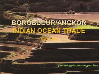
- 28. Many important cities were built as royal capitals during the period from 800 to 1500 A.D. The most important urban development of this period was the construction of the capital of the Khmer state, Angkor, located in northern Cambodia. The Khmer occupied the royal city of Angkor from the 9th to the 15th centuries, although most of the remaining monuments date from the 12th and 13th centuries. Angkor covers about 602 m. Angkor was one of the largest urban places of the period. It was a complete city of homes, workplaces, markets, temple and an extensive agricultural hinterland to support the population.
- 29. Angkor was set in a large plain of primarily alluvial soils located between the Kulen Plateau to the north and the Tonle Sap to the south. The Kulen Plateau provided a constant source of water via the perennial streams that flowed from it to the plains around Angkor. The Tonle Sap was an important inland lake that seasonally flooded with monsoon waters that backed-up from the Mekong River. Many areas in and around Angkor are seasonably wet, with riverine flood waters carrying silt and nutrients that would aid agriculture. The wetlands of the plain were readily sculpted into flat fields with earthen boarders to accommodate rice agriculture that allowed the city to prosper.
- 30. As a planned city, Angkor was sited to take advantage of natural resources in the area, particularly the water and food that the rivers and the Tonle Sap provided. The city itself was laid out on a rectangular, almost grid-like, scheme centered upon the walled compound of Angkor Thom where the palace was located. Roads, city walls, and the walls of temples were oriented to the cardinal directions. Even natural features of the landscape, such as the Siem Reap River, were re-routed to comply with the urban grid.
- 31. A critical component of the city plan was the numerous waterways that provided water for drinking, irrigation, bathing and transportation. The channelized rivers and canals that linked them carried water to and from the large, architectonic detention ponds known as barays. These covered hundreds of acres and held thousands of acre-feet of water. The barays were also used as fish tanks and waterfowl ponds, so they doubled as a food source as well as water source.
- 32. Moats often surrounded important temples or urban areas, separating them from the rest of the urban fabric. One of the largest moats, over 600’ wide, encircled the temple of Angkor Wat. There were smaller pools throughout the city, some of which were used as bathing pools, while others associated with temples may have had a primarily ceremonial function.
- 33. Most structures of Angkor were originally of impermanent materials such as wood, thatch, and glazed tiles, so they no longer remain. Even the walled palace located within the walled compound of Angkor Thom was built with wood. Structures that do remain are those associated with the religious role of Angkor, since only temples and other religious buildings were built of durable sandstone, basalt, brick and laterite brick.
- 34. Angkor’s most important compounds were its temples of Angkor Wat and Bayon. They followed the Indian pattern of spatial development and architectural design representing the temple as a mountain. Specifically, the form of the temples represented the sacred Mount Meru, which in Hindu cosmology was the home of the gods and the human and mythical world that surrounded it.
- 35. Galleries surrounding the main temple represent the foothills around the mount, while the channels of water between the galleries were to represent the ocean and rivers. Each temple compound was both an abstracted and symbolic landscape modeled after the natural and cosmological landscape of India and Southeast Asia.
- 36. Angkor Wat illustrates the common pattern of interior and exterior spatial development found at Khmer sites. The temple was centered upon five elevated, peaked towers that represented the five peaks of Mount Meru. Encircling these towers were concentric rectangular bands of galleries and open courts. The galleries were open air passageways to be walked as part of the entry experience to the main temple.
- 37. Carved scenes drawn from Hindu legends tell their story on surrounding walls. Within the outermost wall of the compound a large open court was originally filled with densely packed thatch and wood dwellings, a temple-centered neighborhood.
- 38. To the exterior of the compound walls the moat separated the temple from the surrounding area of the city. Only by crossing a causeway nearly a quarter of a mile long over this moat could access to the temple precinct be gained. Although Angkor clearly inspired other Southern Asian cities no urban place ever achieved its size and grandeur.
- 39. These bas- reliefs are in remarkable condition. Even though they were done some 400 years after the original construction, and were by then Buddhist, these scenes are derived directly from Hindu mythology. They include the gods Vishna, Shiva and Krishna. Angkor is from a Sanskrit word nagara (Holy City).
- 40. The detail, and the condition of these buildings are remarkable. No doubt due to the robustness of the volcanic rock, unlike Europe where most historical building are built from limestone, which is weak by comparison, and dissolves slowly in rainwater.
- 41. The Angkor period is from 802 to 1432 A.D.. It began when Jaywarman II conducted a ritual that installed him as the universal monarch and ended with the relocation of the Khmers from Angkor to Phnom Penh in 1434. He unified the Khmer nation, and declared independence from Indonesia, thus beginning the glorious period of Angkor. Indravarman I, who ruled Cambodia from around AD877 to around AD889, was the first to set up this irrigation system. It enabled the Khmers to have a densely populated capital in a small area from which they ruled their empire.
- 42. Through this irrigation system, up to three rice crops could be grown each year to feed the population of Angkor. 1006 – 1050 A.D., Suryavarman I is King of Kambuja for nearly 50 years. At the beginning of his reign he embarks on a campaign of territorial expansion, annexing land in the Menam valley to the west and the Mekong valley to the north. Following, there was peace and much building. Suryavarman is responsible for the planning and foundations of much of the city that can be seen at Angkor today.
- 43. He adopts the royal Hindu cult of Devaraja and sets himself up as a representative of the god Siva. 1050 – 1066 A.D., Udayadityavarman II succeeds Suryavarman I and continues building in Angkor. He built the west baray and canals, and submerges some of the old ninth-century city under it. He builds a new city at Angkor, the third city to be built there. His central temple is the Baphuon Temple.
- 44. Suryawarman II took the throne around 1113 and ruled until 1150. He built Angkor Watt. 1181 In order to appease the people who are increasingly adopting Buddhism, Jayavarman becomes a Buddhist himself. Once he stabilizes his enlarged empire, Jayavarman starts a massive building program. This includes the reconstruction of Angkor Thom with the Bayon as the central temple and the building of Ta Prohm and Preah Khan temples.
- 45. The Hindu temples and monuments that were built during the Hindu period was not destroyed , but converted in to Buddhist temples; statues of Lords Shiva and Vishnu were replaced with Lord Buddha. By the 14th century, the biggest threat to Khmer nation came from Siam (Thailand). Watt is Thai name for temple, which must have been added on to Angkor when it became a Threvada Buddhist monument. Threvada BuddhismThrevada Buddhism was spreading fast in thewas spreading fast in the Cambodia – due to theCambodia – due to the strong influence fromstrong influence from neighboring Siamneighboring Siam (Thailand) - and by 1200,(Thailand) - and by 1200, the rulers of Khmer nationthe rulers of Khmer nation had converted tohad converted to Buddhism.Buddhism.
- 46. Sukothai - considered a national hero in Thailand , invaded and plundered Angkor of its precious architecture many times. Due close proximity of Angkor to their perpetual enemy - the rulers of the Angkor , shifted their capitol from Angkor to the present Phnom Penh in the late 15th century. For the next four centuries Angkor Wat remained in ruins covered by gigantic tress and bushes. It was only in the early 20th century it was accidentally discovered by a group of French explorers.
- 47. The most notorious looting occurred in the early 20th century and involved Andre Malraux – who would later become France's cultural affairs minister of De Gaulle cabinet. He and his accomplices removed large sections of the temple and shipped them out of the country. He was later arrested and tried. During the Vietnam war, American jets bombed Angkor. Fortunately, only minor damage was done, but it was considered an act of cultural terrorism on the part of the Americans. In the 1980’s, the Pol Pot's regime vandalized Angkor complex. Stone carvings had been ripped from the temple walls and sold in the antique markets of near by countries by the Khmer rouge soldiers who were living in Angkor, mostly on monkey meat.
- 48. The estimated time for the construction of the Angkor temple was about 30 years. It has been debated whether Angkor Wat was built as a temple or as a tomb. Though the architecture of the Angkor points to a temple, its orientation – the main entrance is west - points that it was built as a tomb. Angkor Wat is an immense monument, occupying a rectangular area of about 500 acres, which is surrounded by a moat that is 600 feet wide. Angkor watt is 213 feet tall, achieved by using three rectangular or square platforms.
- 49. Each platform is progressively smaller and higher than the one below. At the third level, the platform supports five towers – four at the corners and one in the middle. The ingenious plan allows a view of all five towers only from certain angles. The overall profile imitates a lotus bud.
- 50. Angkor Watt temple is most famous for its Bas-reliefs. The Bas - reliefs surround the first level of the temple. The reliefs covers the innermost wall of the first level on all four sides, and covers 12,900 square feet of brilliant sandstone carvings. It extends seven feet from top to bottom. The exquisite and intricate sand stone carvings points to the rich heritage of the Khmer civilization.
- 51. The Bas- reliefs on the western gallery depicts the story of Battle of Mahabharata; south gallery depicts the army of Suryavarma; East gallery portrays the story of churning the Ocean milk; West Gallery portrays the story of battle of Lanka- Ramayana.
- 52. All the Bas –reliefs are rich sandstone carved walls. Among the Bas –reliefs, the churning of the ocean of milk – the Hindu mythical story of Devas and Asuras churning the ocean to obtain the immortal nectar – is breathtaking.
- 53. Angkor Wat was the work of a whole reign - from 1113 to 1150. Even then it was not completely finished. Some of the carving was added after Suryavarman II's death. Angkor was constructed out of sandstone that was quarried many miles away - possibly at Phnom Kulen - and transported to the construction site by the river. It is estimated that as much stone was used in building Angkor Wat as was used in the great pyramid of Khafre in Egypt.
- 54. From the moment a visitor enters the outer gateway of the western approach to Angkor Wat, he is entering the cosmic universe of Hindu mythology. As he crossed the moat from the western terrace, he would recognize the moat (600 feet wide and almost four miles in circumference) as the outer ocean of the universe.
- 55. As he passed through the great stone gallery further into the temple complex, spiritually he would be passing through the Hindu universe. The towers of the central temple would loom up in front of him, and these he would see as the peaks of Mount Meru.
- 56. Then he would begin to climb from terrace to terrace, up wide stairways protected by statues of familiar Hindu gods, until he reached the inner sanctuary. Here, far from the outer gateways that he had passed through earlier, the sacred linga - symbolizing the god Siva.
- 58. Angkor Wat is a whole city in itself. It is a meticulously planned complex which leads the visitor from the outside world, through the Hindu universe and up to the home of the gods. From the gallery in the western outer wall of the temple, the towers of the temple rise almost one-third of a mile away. The terrace gives way to another great entrance which leads to a wide causeway lined with stone balustrades. Buildings which were once libraries, and sunken pools, lie on either side. From here, steps rise up to a terrace, and on to another gallery and a final terrace, built in a cruciform. From here, steps begin the long ascent up the mountain to the five towers that form the pinnacle of Angkor Wat.
- 62. Jayavarman VII (ruled 1181 - 1220) came to power at the age of 60. He built the city of Angkor Thom in a last frenzy of activity as the Khmer Empire began its long decline. The size and layout of this new city, raised on the site of the old city of Angkor, was vast, representing a great king. Its construction required the forced labor of thousands of people, who became increasingly disillusioned with serving their king in this way. The whole city was surrounded by a broad moat 300 feet wide, and eight miles in circumference and was reputably filled with crocodiles. A stone wall 24 feet high and 10 miles long inside the moat offered further protection against enemies.
- 63. The city had five huge gates, each with a causeway crossing the moat. The 60-foot high gateways were elaborately decorated and wide enough to admit a procession of elephants. Each gate was decorated with elephant trunks carved in stone and on top, four huge carved faces of the Bodhisattva, Avalokitesvara looked north, south, east and west.
- 64. Each causeway was bordered by the sculptured balustrades of nagas, and with 54 statues of gods and 54 statues of demons. The causeways led all the way to the temple of Preah Khan, about a mile away. Wide avenues connected the multitude of stone and wooden buildings, temples, terraces and plazas. On the towers around the city walls, huge smiling Buddha faces were carved out of stone. These were in fact all given the face of Jayavarman VII, smiling serenely as he surveyed his city.
- 65. The court, religious leaders, priests and administrative officials lived inside the city walls. Other citizens lived outside by the east and west barays and along the Siem Reap River up to the shores of the great lake. At the center of the city was the Grand Plaza, which led off to all the other buildings. Jayavarman added the Terrace of Elephants (known as the Royal Terrace) along one side of the plaza.
- 66. It was from this 1,100-foot long platform, decorated with bas- relief carvings of elephants, lions and devatas, that audiences watched the grand processions and pageants in the Royal Plaza. On the opposite side of the central square, Jayavarman constructed the 12 Towers of the Cord Dancers, each probably housing a statue or a linga.
- 68. Carvings on the Terrace of the Leper King. Are located north of the Terrace of Elephants on one side of the Royal Plaza, it stands 22 feet high. On top of it there is a mysterious statue, thought to be of Siva or of Yasovarman (AD889 to c. AD900), the builder of the first city of Angkor. There is a legend that he died of leprosy and this statue was later carved in his memory.
- 72. The Bayon was the principal temple built by Jayavarman VII, situated within the walls of the City of Angkor Thom. Jayavarman VII was a Buddhist, but the Bayon contains elements of both Buddhism and Hinduism. It was originally dedicated to the god, Siva, and the initial plan was for only two levels to be built. During construction, it became a Mahayana Buddhist temple and a third level was built and decorated with Buddha statues.
- 73. This third level of the Bayon temple is remarkable. There are 54 towers, each headed by four faces of Avalokitesvara which stare at the visitor from all angles. The bas-relief carvings at the Bayon show an extraordinary tableaux of contemporary Cambodian life on the first level, and stories from the Hindu myths on the second level.
- 75. There are more than 3,600 feet of bas-relief carving on the walls of the Bayon, showing scenes from fiction and from real life, from the past and the present. On the first level, scenes from contemporary Cambodian life, similar to the ones which Chou Ta- Kuan would describe in words nearly 200 years later, cover the walls.
- 76. Real battles between the Chams and the Khmers are shown in gruesome detail with severed limbs littering the scene. People are shown bartering and gossiping, cooking and playing. Many of the scenes of the lives of ordinary people carved in stone at the Bayon can be seen in real life in Cambodia today, proving that little has changed in the
- 79. This temple is considered the most beautiful by many visitors because of its extraordinary relationship with the surrounding jungle which is actually slowly destroying it. Ta Prohm is a very large Buddhist temple built by Jayavarman VII and once tended by 18 high priests and more than 2,500 lesser priests. It housed more than 12,000 people within its enclosures.
- 80. Once it was abandoned, the jungle slowly overtook the buildings, cracking and squeezing walls and prying stones apart. The French restorers decided to leave Ta Prohm exactly as they found it, so today the slow encroachment of the jungle continues to take place.
- 81. Great blocks that fell centuries ago lie on the jungle floor covered in ferns and bushes. The canopy of trees which overhang the whole site obstruct the sunlight, creating a strange green half-light. Everywhere there are insects, birds, bats, frogs and animals - all living in the ruins.
- 84. This is one of the larger temples built by Jaya Varman VII. It has been very well preserved and much of the original temple remains today. It is much smaller than Angkor Wat and the Bayon, but was built to the same form. A central sanctuary is surrounded by galleries, library buildings and other lesser buildings. The temple is surrounded by four walls and a moat.
- 86. Khmer building evolved from the single brick tower to the vast pyramid temples of Angkor Wat and the Bayon. There were significant problems which the architects had to overcome and some of their building methods contributed to the early collapse of their temples. Sandstone blocks were prepared carefully to fit together, but vertical joints were allowed to run on top of one another making walls very unstable. So, often a whole wall fell if one stone near the base became dislodged.
- 87. No mortar was used; just a good fit, weight and gravity was thought sufficient. The Khmers never learnt how to build an arch. European architects used complex arches to cover a space, a technique which had been handed down to them from the Romans over centuries of development. The Khmers had no such example to copy. In order to overcome this difficulty, they used the false arch, or corbelling.
- 88. Large stones were piled on top of one another, reaching inwards as far as possible and touching at the top. An arched roof over a space was thus formed, but it was not as stable as the real arch, and these vaults often collapsed in the centuries after Angkor was abandoned.