1. 6
Types of Remote Sensing System
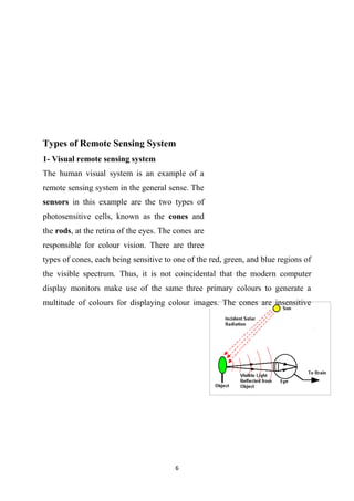
1- Visual remote sensing system
The human visual system is an example of a
remote sensing system in the general sense. The
sensors in this example are the two types of
photosensitive cells, known as the cones and
the rods, at the retina of the eyes. The cones are
responsible for colour vision. There are three
types of cones, each being sensitive to one of the red, green, and blue regions of
the visible spectrum. Thus, it is not coincidental that the modern computer
display monitors make use of the same three primary colours to generate a
multitude of colours for displaying colour images. The cones are insensitive
2. 7
under low light illumination condition, when their jobs are taken over by the
rods. The rods are sensitive only to the total light intensity. Hence, everything
appears in shades of grey when there is insufficient light. As the objects/events
being observed are located far away from the eyes, the information needs a
carrier to travel from the object to the eyes. In this case, the information carrier
is the visible light, a part of the electromagnetic spectrum. The objects
reflect/scatter the ambient light falling onto them. Part of the scattered light is
intercepted by the eyes, forming an image on the retina after passing through the
optical system of the eyes. The signals generated at the retina are carried via the
nerve fibres to the brain, the central processing unit (CPU) of the visual system.
These signals are processed and interpreted at the brain, with the aid of previous
experiences. The visual system is an example of a "Passive Remote Sensing"
system which depends on an external source of energy to operate. We all know
that this system won't work in darkness.
2- Optical Remote Sensing
In Optical Remote Sensing, optical sensors detect
solar radiation reflected or scattered from the
earth, forming images resembling photographs
taken by a camera high up in space. The
wavelength region usually extends from the
visible and near infrared VNIR to the short-wave
infrared SWIR. Different materials such as water, soil, vegetation, buildings and
roads reflect visible and infrared light in different ways. They have different
colours and brightness when seen under the sun. The interpretations of optical
images requires the knowledge of the spectral reflectance signatures of the
various materials (natural or man-made) covering the surface of the earth.
3. 8
3-Infrared Remote Sensing
Infrared remote sensing makes use of infrared sensors to detect infrared
radiation emitted from the Earth's surface. The middle-wave infrared (MWIR)
and long-wave infrared (LWIR) are within the thermal infrared region. These
radiations are emitted from warm objects such as the Earth's surface. They are
used in satellite remote sensing for measurements of the earth's land and sea
surface temperature. Thermal infrared remote sensing is also often used for
detection of forest fires, volcanoes, oil fires.
4-Microwave Remote Sensing
There are some remote sensing satellites which carry
passive or active microwave sensors. The active
sensors emit pulses of microwave radiation to
illuminate the areas to be imaged. Images of the
earth surface are formed by measuring the
microwave energy scattered by the ground or sea
back to the sensors. These satellites carry their own "flashlight" emitting
microwaves to illuminate their targets. The images can thus be acquired day
4. 9
and night. Microwaves have an additional advantage as they can penetrate clouds.
Images can be acquired even when there are clouds covering the earth surface. A
microwave imaging system which can produce high resolution image of the Earth
is the synthetic aperture radar (SAR). Electromagnetic radiation in the
microwave wavelength region is used in remote sensing to provide useful
information about the Earth's atmosphere, land and ocean. When microwaves
strike a surface, the proportion of energy scattered back to the sensor depends
on many factors:
Physical factors such as the dielectric constant of the surface materials
which also depends strongly on the moisture content;
Geometric factors such as surface roughness, slopes, orientation of the
objects relative to the radar beam direction;
The types of landcover (soil, vegetation or man-made objects).
Microwave frequency, polarisation and incident angle.
5-Radar Remote Sensing
Using radar, geographers can effectively map out
the terrain of a territory. Radar works by sending
out radio signals, and then waiting for them to
bounce off the ground and return. By measuring the
amount of time it takes for the signals to return, it is
possible to create a very accurate topographic map.
An important advantage to using radar is that it can penetrate thick clouds and
moisture. This allows scientists to accurately map areas such as rain forests,
which are otherwise too obscured by clouds and rain. Imaging radar systems are
versatile sources of remotely sensed images, providing daynight, all-weather
imaging capability. Radar images are used to map landforms and geologic
structure, soil types, vegetation and crops, and ice and oil slicks on the ocean
surface.
5. 10
Synthetic Aperture Radar (SAR)
In synthetic aperture radar (SAR) imaging, microwave pulses are transmitted by
an antenna towards the earth surface. The microwave energy scattered back to
the spacecraft is measured. The SAR makes use of the radar principle to form
an image by utilising the time delay of the backscattered signals. In real aperture
radar imaging, the ground resolution is limited by the size of the microwave
beam sent out from the antenna.
6-Satellite Remote Sensing
In this, you will see many remote sensing images
acquired by earth observation satellites. These
remote sensing satellites are equipped with
sensors looking down to the earth. They are the
"eyes in the sky" constantly observing the earth as
they go round in predictable orbits. Orbital
platforms collect and transmit data from different
parts of the electromagnetic spectrum, which in
conjunction with larger scale aerial or ground-based sensing and analysis
provides researchers with enough information to monitor trends. Other uses
include different areas of the earth sciences such as natural resource
management, agricultural fields such as land usage and conservation, and
national security and overhead, ground-based and stand-off collection on border
areas.
6. 11
How Satellites Acquire Images
Satellite sensors record the intensity of electromagnetic radiation (sunlight)
reflected from the earth at different wavelengths. Energy that is not reflected by
an object is absorbed. Each object has its own unique 'spectrum', some of which
are shown in the diagram below.
Remote sensing relies on the fact that particular features of the landscape such
as bush, crop, salt-affected land and water reflect light differently in different
wavelengths. Grass looks green, for example, because it reflects green light and
absorbs other visible wavelengths. This can be seen as a peak in the green band
in the reflectance spectrum for green grass above. The spectrum also shows that
grass reflects even more strongly in the infrared part of the spectrum. While this
can't be detected by the human eye, it can be detected by an infrared sensor.
Instruments mounted on satellites detect and record the energy that has been
reflected. The detectors are sensitive to particular ranges of wavelengths, called
'bands'. The satellite systems are characterised by the bands at which they
measure the reflected energy. The Landsat TM satellite, which provides the data
used in this project, has bands at the blue, green and red wavelengths in the
visible part of the spectrum and at three bands in the near and mid infrared part
of the spectrum and one band in the thermal infrared part of the spectrum. The
satellite detectors measure the intensity of the reflected energy and record it.
7. 12
7- Airborne Remote Sensing
In airborne remote sensing, downward or sideward
looking sensors are mounted on an aircraft to obtain
images of the earth's surface. An advantage of
airborne remote sensing, compared to satellite
remote sensing, is the capability of offering very
high spatial resolution images (20 cm or less). The
disadvantages are low coverage area and high cost
per unit area of ground coverage. It is not cost-effective to map a large area
using an airborne remote sensing system. Airborne remote sensing missions are
often carried out as one-time operations, whereas earth observation satellites
offer the possibility of continuous monitoring of the earth.
8-Acoustic and near-acoustic remote sensing
Sonar: passive sonar, listening for the sound made
by another object (a vessel, a whale etc); active
sonar, emitting pulses of sounds and listening
for echoes, used for detecting, ranging and
measurements of underwater objects and terrain.
Seismograms taken at different locations can locate and measure
earthquakes (after they occur) by comparing the relative intensity and
precise timing.