Neighbourhood planning
•
4 likes•3,005 views

Academic Exercise of Preparation of Neighbourhood Plan

Recommended
More Related Content
What's hot
What's hot (20)
Similar to Neighbourhood planning
Similar to Neighbourhood planning (20)
Recently uploaded
Recently uploaded (20)
Neighbourhood planning
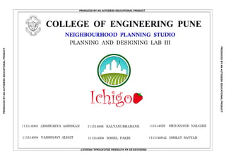
- 1. Ichigo COLLEGE OF ENGINEERING PUNEC O L L E G E OF P O O N A I R E ENIGNE NG S TR E N G T H T R U T H E C N AR UDNE NEIGHBOURHOOD PLANNING STUDIO PLANNING AND DESIGNING LAB III 111514003 AISHWARYA ASHOKAN 111514004 VAISHNAVI ALHAT 111514006 KALYANI BHADANE 111514029 SHIVANAND NALGIRE 1115140042 ISHRAT SAYYAD111514008 SOHEL FAKIR PRODUCED BY AN AUTODESK EDUCATIONAL PRODUCT PRODUCEDBYANAUTODESKEDUCATIONALPRODUCT PRODUCEDBYANAUTODESKEDUCATIONALPRODUCT PRODUCEDBYANAUTODESKEDUCATIONALPRODUCT
- 2. COLLEGE OF ENGINEERING, PUNE S. Y. B. TECH. PLANNING DATE SCALE SHEET. NO.SUB. NO. MIS NO: 111514003, 04, 06, 08, 29, 42 SIGN LOGONORTH N C O L L E G E OF P O O N A I R E ENIGNE NG S TR E N G T H T R U T H E C N AR UDNE GROUND SCENARIO : Influx of IT has boosted up the residential demand in Pune especially areas surrounding Hinjewadi, Wakad, Pashan. Hinjewadi & Tathavade vicinity (around lavale) is developing as Educational hub. Reputed campuses like Symbiosis International University, Flame University, Bharati Vidyapeeth Group of Institutes are located in the vicinity. Nestled in the hills on one side, Lavale is an upcoming attraction to IT professionals and stakeholders. PULL FACTORS OF THE TOWNSHIP : Scenic beauty of hills along with peaceful surrounding nature. Hinjewadi Rajiv Gandhi IT park at just 8 km. At 10 km from Kothrud and 8 km from Pashan. Balewadi Stadium at just 7 km distance. Oxford Golf Resort at 2 km. Flame University Campus at walkable distance. Symbiosis International University at just 2 km. 3 km away from Bharati Vidyapeeth Group of Institutes. Proximity to Mumbai - Pune Expressway. 33 IT companies in 8 km radius. SITE Vidya Valley School International School of Business Symbiosis International University Lavale Universal Solutions Pvt. Ltd. Niasa College Suryadatta College of Management ABM Institute VIT's PVP School of Architecture Bharati Vidyapeeth Group of Institutes Symbiosis Institutes of Technology Nande Chande Bavdhan Gaon Sunarwadi Mumbai-PuneExpressway AH47(AsianHighway) ToMumbai(100km) Hinjewadi-PirangutRoad High Energy Research Lab Manas Lake And Resort Bhare Mulkhed Hinjewadi Lake Balewadi Stadium Pashan Kothrud Oxford Golf Resort Balewadi Stadium Mula River Bharati Vidyapeeth Hinjewadi Rajiv Gandhi IT Park Manas Lake Natural Hills & Forest Area Mumbai - Pune Expressway Infotech Park Flame University REGIONAL CONTEXT Megapolis Township TCS SCALE: 1:40400 NEIGHBOURHOOD PLANNING : REGIONAL CONTEXT 8/12/16 1:40400 1 Lake Mercedes Benz Institute Hinjewadi Hospital Mulshi Road LavaleRoad Ichigo SOURCE: SITE VISIT & GOOGLE EARTH Site Location KEY MAP SCALE: 1:90000
- 3. COLLEGE OF ENGINEERING, PUNE S. Y. B. TECH. PLANNING DATE SCALE SHEET. NO.SUB. NO. MIS NO: 111514003, 04, 06, 08, 29,42 SIGN LOGONORTH N C O L L E G E OF P O O N A I R E ENIGNE NG S TR E N G T H T R U T H E C N AR UDNE South - West Monsoon Winds Summer sun path Winter wind path Climate AnalysisContour Map Of Proposed Site Contour Map Range : 600 m - 655 m NEIGHBOURHOOD PLANNING : PROPOSED SITE 2 > Location of the site : Bavdhan, on the boundary of Mulshi Taluka > Area of the site : 195.77 acres > Latitude : 18.5415 > Longitude : 73.7305 > Climate Zone : Tropical (Moderate) > Wind information : Southwest monsoon winds throughout the year > Average Rainfall : 2841 mm > Temperature information : Average annual temperature : 24.3 deg.C Highest average temperature : 28.1 deg.C Lowest average temperature : 21.3 deg.C Site Details 0 3500 7000 10500 14000 17500 GRAPHICAL SCALE : SCALE 1 : 10000 SOURCES : - The District Environment Atlas (DEA) of Pune District - www.mpcb.gov.in SCALE 1 : 3500 Site Boundary Contour lines LEGEND Building Orientation - > North & south facing vertical walls receive least amount of radiation. > East, southwest & northwest walls will receive same amount of radiation & the west walls will receive the most. > Windows facing east would admit the sun in the morning. Roofs & Walls - > East and especially west walls should be massive whereas north & south walls should be of light weight construction. > To limit heat during strong sunshine hours & store heat during cool period, high thermal capacity structures shall be used. eg: 200 mm concrete slab. Air Flow & Openings - > Solar heat gain is governing the orientation of windows. > Deciduous trees should be planted in this tropical zone since wilting of leaves takes place during winter & hence maximum sunlight can be received. > In summer, deciduous trees shall help to block the incident solar radiations & hence should be planted near the living room. Orientation of buildings on a sloping land - > For prevailing hot winds, trees would act as a buffer. > Openings of the buildings would be so placed so as to absorb cooler winds. > Good views shall be obtained by placing longer sides of the walls towards the water body side. > Vegetation shall be done in order to block the unwanted hot winds on the upland area. > Double roofs shall be provided to minimize the intensity of trapped solar radiations on the roof. Ichigo 8/12/16 Site Location KEY MAP SCALE: 1:90000
- 4. COLLEGE OF ENGINEERING, PUNE S. Y. B. TECH. PLANNING DATE SCALE SHEET. NO.SUB. NO. MIS NO: 111514003, 04, 06, 08, 29,42 SIGN LOGONORTH N C O L L E G E OF P O O N A I R E ENIGNE NG S TR E N G T H T R U T H E C N AR UDNE 650 645 605 610 615 620 625 630 635 640 645 655 650 650 645 605 610 615 620 625 630 635 640 645 Scale 1 : 10000 Scale 1 : 10000 A B Y Z SECTION AB SECTION YZ Proposed Site Soil Map : Scale 1 : 10000 Pune District Soil Map ( Not to scale ) > The area is with steep slopes, highly erosion prone with shallow soils. > The soil is acidic in nature. > It has low electrical conductivity, organic carbon and phosphorous content. > It has a very high potash content. > It has sufficient amount of copper, manganese and zinc but is deficient in iron. > The soil thickness ranges from 1 to 7.5 cm. > For such a type of soil, to impart strength to the building, deep foundation is required. > Pile foundation : Among various types of deep foundations, pile foundation is suitable for this site as the load bearing capacity of the soil is very low. Source : Pune DEA Report 2008 Class VII : Extremely shallow soil Scale 1 : 6800 Non-developable Land Very Flat 8/12/16 3 Steep 8 % Flat FIG. NO. 1 : Slope Analysis Pie Chart TABLE NO. 1 VERTICAL SECTION HORIZONTAL SECTION Horizontal distance Horizontaldistance Very Steep Slope Analysis of the Site : Developable Land 5 - 10 % Slope 10 - 25 % Slope 92 % NEIGHBOURHOOD PLANNING : SITE ANALYSIS > 25 % Slope 2 - 5 % Slope 8 % 29 % 27 % 36 % Feasible for Building Construction (63 %) Feasible for Open Spaces & Services (29 %) Ichigo Site Location KEY MAP SCALE: 1:90000
- 5. COLLEGE OF ENGINEERING, PUNE S. Y. B. TECH. PLANNING DATE SCALE SHEET. NO.SUB. NO. MIS NO: 111514003, 04, 06, 08, 29, 42 SIGN LOGO C O L L E G E OF P O O N A I R E ENIGNE NG S TR E N G T H T R U T H E C N AR UDNE 8/12/16 4 NEIGHBOURHOOD PLANNING : TOWNSHIP THEME ORGANIC FARMING And the overall feasible Solution is ... Urban agriculture is an industry located within ( intra-urban ) or on the fringe ( peri-urban ) of a town, a city or a metropolis, that grows and raises, processes and distributes a diversity of agricultural products from both plants and animals, using human, land and water resources, products and services found in and around that urban area. Ensures safe & healthy world for future generation Boosts immune system Prevents immature aging Tastes better than non - organic food Reduces risk of heart diseases Promotes animal welfare Prevents cancer Reduces presence of pesticides Vermi - compost Animal Husbandry Manure Crop Rotation Biofertilizers Biological Management Green-leaf Manure Organic Farming The climate and the soil typology on the site, favours growth of following crops using organic farming methods : 1. Vegetables like tomato, brinjal, cabbage, cauliflower, onion, peas, leafy vegetables, etc. 2. Fruits like Japanese strawberry ( Ichigo ), grapes, etc. 3. Floriculture EVOLUTION OF THEME ... Aim : To develop a healthy township in terms of physical and mental health of the residents, and the natural environment . Important Health Statistics of Pune : 0 10 20 30 40 50 60 70 80 90 100 Heart Problem s Hyperlipidem iaHypertension Obesity Diabetes 54 21 7778 38 Fig. No. 1 : Major prevalent diseases PercentofPopulation Some of the major factors responsible for these health issues are : - Stressful city life - Polluted environment - Improper lifestyle habits - Consumption of conventional farm products Thus, the township should be based on such a theme that would solve the above problems. Source : State Bureau of Health Intelligence and Vital Statistics, Pune Fig. no. 3 : Organic Farming Fig. no. 4 : Benefits of Organic FarmingFig. no. 2 : Benefits of Urban Agriculture URBAN AGRICULTURE Site Location KEY MAP Ichigo SCALE: 1:90000
- 6. COLLEGE OF ENGINEERING, PUNE S. Y. B. TECH. PLANNING DATE SCALE SHEET. NO.SUB. NO. MIS NO: 111514003, 04, 06, 08, 29, 42 SIGN LOGONORTH N C O L L E G E OF P O O N A I R E ENIGNE NG S TR E N G T H T R U T H E C N AR UDNE 8/12/16 NEIGHBOURHOOD PLANNING : CONCEPT PLAN HIGH INCOME GROUP : Reasons for the allotted position of HIG : Lakeview Proximity to the entrance, hence enhanced accessibility. View of the hills and the horticulture. Proximity to the golf course. Proximity to the garden. Tucked away from the crowd that might be present in the commercial zone. OPEN SPACES (GARDEN) : Reasons for the allotted position of garden: Centrally placed so that it is accessible to all. Closest to the HIG and HMIG so that it provides a calming ambience to their residences. PUBLIC - SEMI PUBLIC SERVICES : Reasons for the allotted position of PSP : Placed so that it is accessible to all income groups. LOW INCOME GROUP : Reasons for the allotted position of LIG: Proximity to potential workplace (urban agricultural land). Affordable land prices. Proximity to Lavale village (workplace, educational institution). MIDDLE INCOME GROUP : Reasons for allotted position of MIG : Reasonably close to the entrance. Proximity to the garden. Proximity to the PSP services provided. HIG HIG MIG MIG LIG PSP PSP SERVICES CO M M ERCIAL LAKE HORTICULTURE FARM LAND OPEN SPACE CONCEPT PLAN URBAN AGRICULTURAL LAND: Reasons for the allotted position of urban agricultural land: Land is undevelopable or developable at very high cost due to very steep slopes. Provides a natural boundary on one side of the township. C:UsersLenovoDesktopUntitled.jpg C:UsersLenovoDesktopimages.png C:UsersLenovoDesktop5024010.jpg C:UsersLenovoDesktopdownload.png C:UsersLenovoDesktopimages (1).png ENTRANCE 1:38800 5 View of lake View of Horticulture 650 645 CONTOUR MAP SCALE 1 : 38800 Summer sun path Winter wind path N South - west Monsoon Winds SCALE; 1:1330 Symbiosis University Flame University Oxford Golf Resort Ichigo O pen Land Site Location KEY MAP SCALE: 1:90000
- 7. : > Should have sufficiently a wide means (not less than 18 m wide). > Should be one continuous unbroken and uninterrupted & in any case should not be less than 40 Ha (100 acres) at one place. The area will be notified as 'special township' by government in Urban Development Department according to section 20 read with section 18 of the MRTP Act 1966. ENVIRONMENT : > Should not involve topographical changes, changes in alignment, etc. > It should have parks / gardens / playgrounds, etc. SPECIAL CONCESSIONS : (a) N. A. Permission - Non - agriculture permission will be automatic. (b) Stamp duty rates should be 50% of prevailing rates of Mumbai Stamp Act. (c) Any special government land falling under township area is granted on terms & conditions. (d) The condition that only the agriculturist is eligible to buy the agriculture land is not applicable. (e) Concessions for Star Category Hotels, Hospitals & Multiplexes / Property Tax shall be provided. COLLEGE OF ENGINEERING, PUNE E S. Y. B. TECH. PLANNING DATE SCALE SHEET. NO.SUB. NO. MIS NO: 111514003, 04, 06, 08, 29, 42 C O L L E G E OF P O O N A I R E ENIGN NG N R U HU SIGN S T G R T E H T T E A N E C LOGO R D NEIGHBOURHOOD PLANNING : REGULATIONS N INFRASTRUCTURE FACILITIES : Water supply - > To develop source for drinking water other than groundwater and to meet daily requirement of minimum 140 litres per capita per day. > Storage capacity of it should be at least 1.5 times of actual required quantity. Drainage and Garbage disposal - > Suitable and environment friendly arrangements for disposal and treatment of sewage and solid waste. Power - > To draw power from existing supply system or arrangement of captive power generation. 6 GENERAL NORMS FOR DIFFERENT LAND USES : (a) Residential - > Out of the total floor area, at least 60% may be used for residential development. > 10% of it shall be used for residential tenements having built up area up to 40 sq.m. (b) Commercial - > Should be properly distributed in hierarchical manner like convenience shopping, community centre, etc. (c) Parks, Gardens & Play Grounds - > 20% of the total area is for Parks/ Gardens/ Playgrounds. > Should be distributed in all residential clusters and kept open to general public. (d) Transport and Communication - > Roads should be developed as per standard and road widths as: (i) Classified Roads as prescribed. (ii) Main road/ Ring road- 18 to 24 m. wide. (iii) Internal road- as per prevailing bye-laws & of minimum width 9 m. F. S. I & FLOATING F. S. I : > Total built - up area / F.S.I of the special township in Residential Zone will be 1.00. > F. S. I for Agriculture / No Development Zone shall be 0.5. > The F. S. I of any uncovered plot can be used anywhere in the township as floating F. S. I. 8/12/16 Source : MR & TP Act 1996 SPECIAL TOWNSHIP SCHEME FOR PUNE REGION AS PER MRTP ACT 1996 Ichigo
- 8. COLLEGE OF ENGINEERING, PUNE S. Y. B. TECH. PLANNING DATE SCALE SHEET. NO.SUB. NO. MIS NO: 111514003, 04, 06, 08, 29,42 SIGN LOGONORTH N C O L L E G E OF P O O N A I R E E NIGNE NG S T R E N G T H T R U T H E C N ARUDNE KEY MAP NEIGHBOURHOOD PLANNING: CALCULATIONS Ichigo Total site area : 195.77acres = 792, 253.082 sq.m. SITE BOUNDARY SCALE: 1:1330 SITE DETAILS: Total site area : 195.77 acres = 792, 253.082 sq.m. Total built up area : 176.13 acres = 712, 772.822 sq.m. Population : 22,382 Transportation Residential Agricultural Open spaces BUILT-UP AREA (%) Public Semi-public Commercial Services LAND USE 50 20 6 10 77 2 GROUND COVERAGE (%) GROUND COVERAGE (SQ.M.) 548, 835 BUILT-UP AREA (SQ.M.) 0 0 0 Higher Middle Income Group (HMIG) 20Higher Income Group (HIG) 109,767 Middle Income Group (MIG) Low Income Group (LIG) Economically Weaker Section (EWS) 32,930 30 40 6 4 BUILT-UP AREA (%) BUILT-UP AREA (SQ.M.) 50% 5% 20% 164,650 219,534 10% 21,954 9.4% 2% 3.6% Residential Agricultural Open spaces Transportation Public Semi-public Commercial Services GROUND COVERAGE (%) GROUND COVERAGE (SQ.M.) TABLE NO. 1 : LAND USE DISTRIBUTION FIG. NO. 1 : LAND USE DISTRIBUTION LEGEND APARTMENTS: Therefore, total built up area for apartments : 109,767 - 7500 = 102,267 sq.m. Built up area excluding 20% area for common spaces : 102,267 - 20,453 = 81,814 sq.m. Built up area of one flat : 120 sq.m. No. of flats : 81,814 / 120 = 682 flats Ground coverage for HIG flats (excluding bungalows) : 40% (Ground Coverage for HIG) = 40% of 71,725 sq.m. = 28,690 sq.m. Permissible no. of floors : Total built up area for flats / Ground coverage = 102,267 / 28,690 = 4 floors Each floor has 4 flats Therefore, no. of floors required : 682 / 4 = 170.5 Each building has 4 floors Hence, no. of buildings : 170.5 / 4 = 43 buildings 396,126 20 30 40 6 4 79,225 118,837 158,450 23,768 15,845 TABLE NO. 2 : DISTRIBUTION OF BUILT UP AREA HIGHER MIDDLE INCOME GROUP (HMIG): Total built up area : 164,650 sq.m. Ground coverage : 118,837 sq.m. Population belonging to HMIG : No. of dwelling units x 4.5 = (1318) x 4.5 = 5931 Built up area excluding 20% area for common spaces : 164,650 - 32,930 = 131,720 sq.m. Built up area of one flat : 100 sq.m. No. of flats : 131,720 / 100 = 1318 flats Ground coverage for HMIG flats : 40% (Ground Coverage for HMIG) = 40% of 118,837 sq.m. = 47,535 sq.m. Permissible no. of floors : Total built up area for flats / Ground coverage = 164,650 / 47,535 = 4 floors Each floor has 4 flats Therefore, no. of floors required : 1318 / 4 = 329.5 Each building has 4 floors Hence, no. of buildings : 329.5 / 4 = 82 buildings HIGHER INCOME GROUP (HIG): Total built up area : 109,767 sq.m. Ground coverage : 79,225 sq.m. Population belonging to HIG : No. of dwelling units x 4.5 = (30+682) x 4.5 =3204 BUNGALOWS: No. of bungalows : 30 Built up area of one bungalow : 250 sq.m. Total built up area of all bungalows : 250 x 30 = 7500 sq.m. INCOME GROUPS Higher Income Group (HIG) : FLAT Higher Middle Income Group (HMIG) Middle Income Group (MIG) Low Income Group (LIG) Economically Weaker Section (EWS) 120 100 85 60 40 AREA OF DWELLING UNIT (SQ.M.) TABLE NO. 3 : SIZE OF DWELLING UNITS INCOME GROUPS Higher Income Group (HIG) : BUNGALOW 250 158,450 39,613 79,225 15,845 74,400 20,500 9.4 2.6 15 5 3 0 0 0 106,916 35,639 21,383 RESIDENTIAL : SCALE: 1:90000 8/12/16 Site location 7
- 9. COLLEGE OF ENGINEERING, PUNE S. Y. B. TECH. PLANNING DATE SCALE SHEET. NO.SUB. NO. MIS NO: 111514003, 04, 06, 08, 29,42 SIGN LOGONORTH N C OL L E G E OF P O O N A I R E ENIGNE NG S TR E N G T H T R U T H E C N AR UDNE NEIGHBOURHOOD PLANNING: CALCULATIONS Ichigo Total site area : 195.77acres = 792, 253.082 sq.m. SITE BOUNDARY SCALE: 1:1330 MIDDLE INCOME GROUP (MIG): Total built up area : 219,534 sq.m. Ground coverage : 158,450 sq.m. Population belonging to MIG : No. of dwelling units x 4.5 = (2066) x 4.5 = 9297 Built up area excluding 20% area for common spaces : 219,543 - 43,907 = 175,627 sq.m. Built up area of one flat : 85 sq.m. No. of flats : 175,627 / 85 = 2066 flats Ground coverage for MIG flats : 40% (Ground Coverage for MIG) = 40% of 158,450 sq.m. = 63,380 sq.m. Permissible no. of floors : Total built up area for flats / Ground coverage = 219,534 / 63,380 = 4 floors Each floor has 4 flats Therefore, no. of floors required : 2066 / 4 = 516.5 Each building has 4 floors Hence, no. of buildings : 516.5 / 4 = 129 buildings LOWER INCOME GROUP (LIG): Total built up area : 32,930 sq.m. Ground coverage : 23,768 sq.m. Population belonging to LIG : No. of dwelling units x 4.5 = (439) x 4.5 = 1975 Built up area excluding 20% area for common spaces : 32,930 - 6586 = 26,344 sq.m. Built up area of one flat : 60 sq.m. No. of flats : 26,344 / 60 = 439 flats Ground coverage for LIG flats : 40% (Ground Coverage for LIG) = 40% of 23,768 sq.m. = 9507 sq.m. Permissible no. of floors : Total built up area for flats / Ground coverage = 32,930 / 9507 = 4 floors Each floor has 6 flats Therefore, no. of floors required : 439 / 6 = 73.16 Each building has 4 floors Hence, no. of buildings : 73.16 / 4 = 18 buildings ECONOMICALLY WEAKER SECTIONS (EWS): Total built up area : 21,954 sq.m. Ground coverage : 15,845 sq.m. Population belonging to EWS : No. of dwelling units x 4.5 = (439) x 4.5 = 1975 Built up area excluding 20% area for common spaces : 21,954 - 4391 = 17,563 sq.m. Built up area of one flat : 40 sq.m. No. of flats : 17,563 / 40 = 439 flats Ground coverage for EWG flats : 40% (Ground Coverage for EWS) = 40% of 15,845 sq.m. = 6338 sq.m. Permissible no. of floors : Total built up area for flats / Ground coverage = 21,954 / 6338 = 4 floors Each floor has 6 flats Therefore, no. of floors required : 439 / 6 = 73.16 Each building has 4 floors Hence, no. of buildings : 73.16 / 4 = 18 buildings PUBLIC AND SEMI-PUBLIC (PSP) : Multipurpose Community Hall Amenities Count Total Area Required (Sq.m.)Area Required (Sq.m.) Primary Schools Senior Secondary Schools Dispensary Community Room Religious Center 4 2 2 4 4 4000 18,000 900 2000 750 1600 16,000 36,000 1800 4000 3000 6400 74,400 COMMERCIAL : Amenities Count Total Area Required (Sq.m.)Area Required (Sq.m.) Convenience Shopping Centres Local Area Shopping Centres Banks 5 2 5 2000 5000 100 10,000 10,000 500 20,500 Pre-primary Schools / Nursery 800 9 7200 2 TABLE NO. 4 : AMENITIES PROVIDED IN PSP TABLE NO. 5 : AMENITIES PROVIDED IN COMMERCIAL KEY MAP SCALE: 1:90000 Site location 8/12/16 8
- 10. COLLEGE OF ENGINEERING, PUNE S. Y. B. TECH. PLANNING DATE SCALE SHEET. NO.SUB. NO. MIS NO: 111514003, 04, 06, 08, 29,42 SIGN LOGONORTH N C O L L E G E OF P O O N A I R E ENIGNE NG S TR E N G T H T R U T H E C N AR UDNE 8/12/16 Site Location Key Map Not to Scale NEIGHBOURHOOD PLANNING : MASTER PLAN Ichigo JAPANESE GARDEN COMMERCIAL VEGETABLE MARKET TOWN HALL PRIMARY SCHOOL DISPENSARY TRAINING CENTRE LOCALSHOPPINGCENTRE URBAN AGRICULTURE LAND U.A. UTILITY LAND SPO RTS FIELD VEGETABLE MARKET SCHOOL PRIMARY SCHOOL COMMUNITY HALL RELIGIOUS CENTRE DISPENSARY COMMERCIAL E.S.R. G.S.R. STORM W ATER TREATM ENT PLANT CONVENIENT SHOPPING CENTRE 1:2500 SCALE :1:2500 RESIDENTIAL OPEN SPACE COMMERCIAL PSP SERVICES AGRICULTURAL LAND LEGEND TRANSPORTATION 50% 5% 20% 10% 9.4% 2% 3.6% FIG. NO. 1 : LAND USE DISTRIBUTION Transportation Residential Agricultural Open spaces Public Semi-public Commercial Services 396,126 158,450 39,613 79,225 15,845 74,400 20,500 LAND USE AREA (SQ M) TABLE NO. 1 : LAND USE DISTRIBUTION MASTER PLAN TOTAL SITE AREA : 792, 253.082 sq.m. 18 M W IDE ROAD TOWARDS LAVLE NANDED ROAD ENTRANCE 12M W IDE ROAD 9 M W IDE ROAD 12 M W IDE RO AD 12 M W IDE RO AD 18 M WIDE ROAD 9 M WIDE ROAD 9
- 11. Sr no. Legend Dimensions 1) W1 1.6 m x 0.23 m 2) W2 0.7 m x 1.2 m 3) W3 0.8 m x 1.2 m 4) D1 1.2 m x 2 m 5) D2 1.0 m x 2 m 6) D3 0.8 x 2 m 7) D4 0.7 x 2 m 8) D5 2.1 x 2 m COLLEGE OF ENGINEERING, PUNE S. Y. B. TECH. PLANNING DATE SCALE SHEET. NO.SUB. NO. MIS NO: 111514003, 04, 06, 08, 29,42 SIGN LOGONORTH N C O L L E G E OF P O O N A I R E ENIGNE NG S TR E N G T H T R U T H E C N AR UDNE W = Window , D = Door ROW HOUSE PLAN : STAIRCASE DESIGN CALCULATIONS : Height of step (Riser) : 0.15 m Width of step (Tread) : 0.25 m No. of stairs in staircase : 20 Floor height : 3 m Table No. 1 : Ichigo KEY MAP KITCHEN (3.3 X 4 m) DINING ROOM (3.3 X 4.8 m) BEDROOM (4.5 X 3.65 m) LIVING ROOM (5.3 X 4 m) W.C (1.2 X 2.15 m) FAMILY ROOM (3.3 X 4.8 m) CHILDREN'S BEDROOM (3.2 X 4.1 m) DRY BALCONY (1.25 X 2 m) WASHROOM (1.25 X 2 m) MASTER BEDROOM (4.9 X 4.5 m) W.C (1.2 X 2.15 m) PUJA ROOM (4 X 2.2 m) GYM (4 X 2.2 m) WASHROOM (1.2 X 2 m) WASHROOM (2.15 X 1.2 m) BALCONY (5.2 X 3.8 m) BALCONY (4.4 X 3.1 m) UP DOWN ENTRANCE GROUND FLOOR PLAN FIRST FLOOR PLAN D1 D2 W1 W2 D3 D3 W1 W3 W1 W1 W2 D1 D4 D4 W2 W2 D4 D4 W1 W3 D2 D3 D5 W1 W1 W2 D4 D3 W1 Scale = 1: 40 8/12/16 1: 40 NEIGHBOURHOOD PLANNING : ROW HOUSE PLAN Location of row houses Scale 1 : 1330 UP DOWN DOWN 11
- 12. COLLEGE OF ENGINEERING, PUNE S. Y. B. TECH. PLANNING DATE SCALE SHEET. NO.SUB. NO. MIS NO: 111514003, 04, 06, 08, 29,42 SIGN LOGONORTH N C OL L E G E OF P O O N A I R E ENIGNE NG S TR E N G T H T R U T H E C N AR UDNE NEIGHBOURHOOD PLANNING : UNIT DESIGN Ichigo DIMENSIONSSCHEDULE OF ITEMSSR.NO. 1 2 3 4 5 6 7 8 9 10 11 12 13 14 15 16 17 18 19 20 21 22 23 LIVING ROOM 4.6 x 4.0 BALCONY 3.9 x 1.1 KITCHEN DINING AREA 3.1 x 2.4 2.7 x 2.2 DRY BALCONY BEDROOM 1 1.5 x 1.3 4.4 x 4.0 BEDROOM 2 4.2 x 3.5 WASHROOM 2 BEDROOM 3 WASHROOM 3 PLUMBING DUCT 1 1.9 x 1.8 4.2 x 3.5 1.8 x 1.5 3.9 x 0.8 PLUMBING DUCT 2 3.8 x 0.8 GARBAGE DUCT 2.4 x 0.5 LIFT CAR 2.0 x 1.5 STAIRCASE WINDOW 1 3.8 x 3.1 3.1 x 2.0 WINDOW 2 WINDOW 3 WINDOW 4 1.8 x 1.2 0.7 x 0.6 1.2 x 0.8 DOOR 1 2.0 x 1.1 2.0 x 0.9 DOOR 2 DOOR 3 2.0 x 1.3 LEGEND WASHROOM 1 1.9 x 1.8 GD LC SC W1 W2 W3 W4 D1 D2 D3 PD 1 PD 2 W2 W3 W3 W2 W2 W3 W4 W1 D2 D2 D2 D2 D2 D3 D1 D3 LIVING ROOM(DINING) 5.7 x 4.0 3.5 X 3.5 4.0 X 3.0 3.3 X 2.8 4.0 X 3.0 2.3 X 1.6 1.5 X 1.2 1.5 X 1.4 2.7 X 1.5 3.8 X 0.6 4.3 X 0.6 2.0 X 2.0 4.2 X 3.0 3.3 X 1.0 1.7 X 0.5 2.0 X 1.0 2.0 X 0.7 2.2 X 2.0 1.5 X 1.2 0.7 X 0.7 DIMENSIONSSCHEDULE OF ITEMSSR.NO. 1 2 3 4 5 6 7 8 9 10 11 12 13 14 15 16 17 18 19 20 KITCHEN BEDROOM 1 BEDROOM 2 WASHROOM 2 BEDROOM 3 LIFT CAR STAIRCASE WINDOW 1 WINDOW 2 DOOR 1 DOOR 2 DOOR 3 LEGEND WASHROOM 1 LC SC W1 W2 D1 D2 D3 PD FOYER BALCONY 1 BALCONY 2 BALCONY 3 PLUMBING DUCT PRESSURIZATION DUCTPRD FLOOR PLAN OF 3BHK Scale: 1:110 Area: 120 sq.m. Floor to floor height: 3.6 m. No. of floors : 4 LIVING ROOM 4.6 x 4.0 FLOOR PLAN OF 2.5 BHK DWELLING UNIT SCALE: 1:130 FLOOR PLAN OF 2.5BHK Scale: 1:190 Area: 100 sq.m. Floor to floor height: 3.6 m. No. of floors : 4 D1 D2 FLOOR PLAN OF 3 BHK DWELLING UNIT SCALE: 1:80 BEDROOM 2 4.2 x 3.5 DINING AREA 2.7 x 2.2 BALCONY 2.7 x 1.5 BEDROOM 1 4.4 x 4.0 KITCHEN 3.1 x 2.4 W1 BALCONY 3.9 x 1.1 W1 W1 D1 W1 D2 W2 D1 D3 BED- ROOM 2 4.0 x 3.0 W2 LIVING ROOM (DINING) 5.7 x 4.0 BED- ROOM 3 3.3 x 2.8 KITCHEN 3.5 x 3.5 BED- ROOM 1 4.0 x 3.0 BALCONY 3.8 x 0.6 BALCONY 4.3 x 0.6 BEDROOM 3 4.2 x 3.5 D1 D1 3 BHK UNIT DESIGN 2.5 BHK UNIT DESIGN SCALE: 1:1330 KEY MAP LOCATION OF HIG HOUSING LOCATION OF HMIG HOUSING TABLE NO. 1 TABLE NO. 2 D1 8/12/16 12
- 13. COLLEGE OF ENGINEERING, PUNE S. Y. B. TECH. PLANNING DATE SCALE SHEET. NO.SUB. NO. MIS NO: 111514003, 04, 06, 08, 29,42 SIGN LOGONORTH N C O L L E G E OF P O O N A I R E ENIGNE NG S TR E N G T H T R U T H E C N AR UDNE 2 BHK FLOOR DESIGN: SCALE 1 : 100 Living room (L) Master Bedroom (M) Bedroom (B) Kitchen (K) Washroom (WR) 1) 2) 3) 4) 5) Sr. No. Rooms Dimensions Sr no. Legend Dimensions 1) W1 1.5 m x 1.2 m 2) W2 0.6 m x 1.2 m 3) D1 1 m x 2 m 4) D2 0.8 m x 2 m 5) D3 2 m x 2 m 6) B1 1 m x 3 m 7) PD 2.8 m x 2.5 m 3.7 x 4.2 m 1.5 x 2 m 5.2 x 4 m 4.2 x 4 m 4.6 x 4.2 m 8) B2 2.5 m x 1 m TABLE NO. 3 TABLE NO. 4 STAIRCASE DESIGN CALCULATIONS: Height of step (Riser) : 0.15 m Width of step (Tread) : 0.25 m No. of stairs in staircase : 20 Floor height : 3 m Passage SCALE 1 : 40 SCALE 1 : 100 Ichigo KEY MAP Legend NEIGHBOURHOOD PLANNING : UNIT DESIGN Living room (3.7 x 4.2) Kitchen (5.2 x 4) Bedroom (4.2 x 4) MasterBedroom (4.6x4.2) Balcony (3 x 1) Dry Balcony (2.5 x 1) Balcony (3 x 1) 8/12/16 13 Site Location Scale 1 : 1330
- 14. D2 B1 1 BHK FLOOR DESIGN: Living room (L) Bedroom (B) Kitchen (K) Washroom (WR) 1) 2) 3) 4) Sr. No. Rooms Dimensions 3.6 x 5.3 m 2.3 x 1.2 m 3.4 x 5.2 m 4.8 x 3.1 m W1 D1 D2 W2 1) 2) 3) 4) Sr. No. Legends Dimensions 1.2 x 1.2 m 0.6 x 1.2 m 0.8 x 2 m 1 x 2 m 5) 6) B1 B2 1 x 2.5 m 4.5 x 1 m W1 W1 D1 D1 D2 W2 Living room (3.6 x 5.3) (WR) TABLE NO. 1 TABLE NO. 2 7) PD (Plumbing Duct) 2.2 x 1.4 m PD COLLEGE OF ENGINEERING, PUNE S. Y. B. TECH. PLANNING DATE SCALE SHEET. NO.SUB. NO. MIS NO: 111514003, 04, 06, 08, 29,42 SIGN LOGONORTH N C O L L E G E OF P O O N A I R E ENIGNE NG S TR E N G T H T R U T H E C N AR UDNE STAIRCASE DESIGN CALCULATIONS: Height of step (Riser) : 0.15 m Width of step (Tread) : 0.25 m No. of stairs in staircase : 20 Floor height : 3 m Passage SCALE 1 : 115 SCALE 1 : 115 SCALE 1 : 35 Ichigo UNIT FLOOR PLAN: B2 W1 Legend NEIGHBOURHOOD PLANNING : UNIT DESIGN Kitchen (3.4 x 5.2) Bedroom (4.8x3.1) Balcony (4.5x1) 8/12/16 14 KEY MAP Site Location Scale 1 : 1330
- 15. B Sr no. Legends Rooms Dimensions 1) Living room (L) 3.4 x 4.7 m 2) Kitchen (K) 4.0 x 4.7 m 3) Washroom (WR) 1.2 x 2.0 m W2 D1 D1 B2 B1PD 1 D1 D1 PD 2 W1 W1 W1 W1 D1 D1 W2 D2 D2 W2 D2 D2 W1 W1 D1 D1 B4 Sr no. Legend Dimensions 1) W1 0.6 m x 1.2 m 2) W2 1.2 m x 1.2 m 3) D1 0.6 m x 2 m 4) D2 0.8 m x 2 m 5) D3 0.9 m x 2 m 6) B 0.9 x 3.5 m 7) PD 0.8 x 2.5 m W2 W2 D1 D1 B2 B1 PD 1 D1 D1 PD 2 W1 W1 W1 W1 D1 D1 W2 D2 D2 W2 D2 D2 W1 W1 D1 D1 B4 W2 WR WR WRWR WR WR WRWR D2 PD W1 WR COLLEGE OF ENGINEERING, PUNE S. Y. B. TECH. PLANNING DATE SCALE SHEET. NO.SUB. NO. MIS NO: 111514003, 04, 06, 08, 29,42 SIGN LOGONORTH N C O L L E G E OF P O O N A I R E ENIGNE NG S TR E N G T H T R U T H E C N AR UDNE W2 W2 W2 W2 W2 W2 W2 W2 D2 B D1 D1 D2 D2 D3 D3 D1 D1 D2 D1 D1 D2 B B B B PD PD PD W1 W1 W1 W1 W1 W1 K WR WR WR WR W - Window , D - Door , B - Balcony , PD - Plumbing Duct 1 RK FLOOR DESIGN: STAIRCASE DESIGN CALCULATIONS: Height of step (Riser) : 0.15 m Width of step (Tread) : 0.25 m No. of stairs in staircase : 20 Floor height : 3 m Passage TABLE NO. 1 TABLE NO. 2 SCALE 1:80 SCALE 1 : 95 SCALE 1 : 25 Ichigo UNIT FLOOR PLAN: Living room (3.4 x 4.7) Kitchen (4 x 4.7) Balcony (3.5 x 0.9) 8/12/16 15 KEY MAP Site Location Scale 1 : 1330 NEIGHBOURHOOD PLANNING : UNIT DESIGN
- 16. COLLEGE OF ENGINEERING, PUNE S. Y. B. TECH. PLANNING DATE SCALE SHEET. NO.SUB. NO. MIS NO: 111514003, 04, 06, 08, 29, 42 SIGN LOGO C O L L E G E OF P O O N A I R E ENIGNE NG S TR E N G T H T R U T H E C N AR UDNE NEIGHBOURHOOD PLANNING : ROW HOUSE KEY MAP Ichigo SITE PLAN OF A ROW HOUSE LANDSCAPE PLAN OF A ROW HOUSE 1.5 0.23 2 2 2.5 30.5 1.15 4.73 12.5 20 Down Down Up Up Entrance CURRY LEAVES CUCUMBER CORIANDER CABBAGE GREEN CHILLIES TOMATO 1 2 Side View of the Swing Stilt Parking Elevation Size of Plot : 12.5 m x 20 m PAVERS LAWN 8/12/16 16 SCALE 1 : 50 Entrance Location of row houses Scale 1 : 1330
- 17. COLLEGE OF ENGINEERING, PUNE S. Y. B. TECH. PLANNING DATE SCALE SHEET. NO.SUB. NO. MIS NO: 111514003, 04, 06, 08, 29,42 SIGN LOGONORTH N C OL L E G E OF P O O N A I R E ENIGNE NG S T R E N G T H T R U T H E C N AR UDNE NEIGHBOURHOOD PLANNING : SITE PLAN OF HIG Ichigo PARKING CALCULATIONS FOR PART A No. of flats per building : 16 Parking demand per building : 32 Parking demand for part A : 96 Adding 10% for visitors' parking, total parking demand : 106 Size of a parking bay : 5.0 m x 2.5 m No. of bays in stilts of one building : 23 Total no. of parking bays : 69 Hence, no. of bays in surface parking : 106-69 = 37 PARKING CALCULATIONS FOR PART B No. of flats per building : 16 Parking demand per building : 32 Parking demand for part B : 32 x 9 = 288 Adding 10% for visitors' parking, total parking demand : 317 Size of a parking bay : 5.0 m x 2.5 m No. of bays in stilts of one building : 23 Hence, no. of bays in surface parking : 317 - (23 x 9) = 110 Surface parking cannot accommodate 110 bays. Therefore, basement parking is provided. Area of basement parking : 12,264 sq.m. No. of parking bays in the basement : 12, 264 / 35 = 350 19.3861 14.2721 14.5050 7.0201 7.1011 17.0697 14.8333 16.0361 15.2077 7.0211 6.2468 7.3915 7.7647 7.6117 9.6075 22.2826 8.4128 1.015 1.1074 7.8402 12.0647 12.8518 9.1311 11.6441 8.3066 9 m. wide road 12 m . wide road 6 m. wide road PLAN AND ELEVATION OF STILT PARKING ELEVATION OF BASEMENT PARKING SITE PLAN OF HIGHER INCOME GROUP HOUSING SCALE: 1:500 ALL DIMENSIONS ARE IN METRES SCALE: 1:310 SCALE: 1:200 3.6 M 3.6 M SCALE: 1:1330 KEY MAP LOCATION OF HIG HOUSING SOURCE: IRC STANDARDS FOR PARKING 8/12/16 17 PRODUCED BY AN AUTODESK EDUCATIONAL PRODUCT PRODUCEDBYANAUTODESKEDUCATIONALPRODUCT PRODUCEDBYANAUTODESKEDUCATIONALPRODUCT PRODUCEDBYANAUTODESKEDUCATIONALPRODUCT
- 18. COLLEGE OF ENGINEERING, PUNE S. Y. B. TECH. PLANNING DATE SCALE SHEET. NO.SUB. NO. MIS NO: 111514003, 04, 06, 08, 29,42 SIGN LOGONORTH N C O L L E G E OF P O O N A I R E ENIGNE NG S TR E N G T H T R U T H E C N AR UDNE NEIGHBOURHOOD PLANNING: LANDSCAPE PLAN (HIG) Ichigo LANDSCAPE PLAN FOR HIGHER INCOME GROUP HOUSING LANDSCAPE PLAN FOR HIGHER INCOME GROUP HOUSING SCALE: 1:1330 KEY MAP LOCATION OF HIG HOUSING ELEVATION OF SWING-SLIDE SET DOG PARK ELEVATION OF SUNBATHING CHAIR SKATING PARK 9 M. WIDE ROAD 6 M. WIDE ROAD 12 M .W ID E R O AD CYCLING TRACK ENTRANCE TO BASEMENT ELEVATION OF PERGOLA & SEATING AREA CLUB HOUSE GREEN HOUSE ELEVATION OF FOUNTAIN 8/12/16 18 SCALE: 1:420 INDEX Gulmohar tree Neem tree Arjun tree Coconut tree Green ash tree Periwinkle shrub Rose shrub PRODUCED BY AN AUTODESK EDUCATIONAL PRODUCT PRODUCEDBYANAUTODESKEDUCATIONALPRODUCT PRODUCEDBYANAUTODESKEDUCATIONALPRODUCT PRODUCEDBYANAUTODESKEDUCATIONALPRODUCT
- 19. E COLLEGE OF ENGINEERING, PUNE S. Y. B. TECH. PLANNING DATE SCALE SHEET. NO.SUB. NO. MIS NO: 111514003, 04, 06, 08, 29,42 SIGN LOGONORTH N C O U L L E G C OF P O O N A I R E ENIGNE NG S TR E N G T H T R T H E N AR UDNE A6 A1 A A3 A5 B4 B1 B6 A4 B3 B2 B5 C2 C1 C3 SCALE 1:350 PARKING CALCULATIONS : 1. Requirements of one dwelling unit or flat : 1 car and 1 two-wheeler 2. Total dwelling in units in study sector : 32 x 15 = 480 dwelling units 3. Total parking requirement (In terms of no. of cars ) : 480 x 1 + 480 x 0.5 = 720 4. Providing 10% for visitors parking = 720 x 10 100=72 5. Total car parking requirement = 800 Parking Management : Stilt parking : a.15 cars in one building footprint b. Total cars in Stilt parking : 225 Underground Parking: c. Remaining cars 800 - 225 = 575 cars d. Area required for 575 cars in underground parking = 575 x 35 = 20125 sq.m e. Setback for underground parking area = 3 m f. Area availabale after setback for parking = 23100sq.m g. Ramp Design : 1:10 gradient ( 3m floor height ) Runway required : 30 m 0 1700 3400 8500 Scale: Scale: 5100 6800 Elevation AB Ichigo BUILDING SETBACK Building Type Setback A3-A4 and B1-B2 8.75 M A4-A5 and B5-B6 7 M C1-C2-C3 9 M Not to the Scale B D Scale: 1:400 C 18 m W ide road 12m W ideroad 12m W ideroad ENTRY Elevation CD EXIT FROM BASEMENT PARKING 30 M Scale: 1:100 Section of Ramp: (EF) RAMP RAMP DOW N UP E F Basement Level (Underground Parking) Ground Level NEIGHBOURHOOD PLANNING : SITE PLAN (HMIG) Towards Japanese garden 10m 6m SITE PLAN FOR HIGHER MIDDLE INCOME GROUP Ground Level Basement Level (Underground Parking) Basement parking area SCALE: 1:1330 KEY MAP LOCATION OF HMIG HOUSING Setback boundary of parking area 8/12/16 19
- 20. RAMP PLANTING DETAILS SR. NO. NAME BOTANICAL NAME HEIGHT CANOPY SPACING NATURE 1 Ashoka Polyalthia longifolia 9 - 10 m 0.8 - 0.9 m 0.7m Evergreen 2 Rose Rosa 0.5 - 1 m 0.5 - 1 m Continuos Ornamental 3 Arjun Temilania arjuna 25- 30 m 2 - 3 m Patches Ornamental 4 Periwinkle Contarantus 1 - 2 m 0.5 - 1 m Continuos Ornamental COLLEGE OF ENGINEERING, PUNE S. Y. B. TECH. PLANNING DATE SCALE SHEET. NO.SUB. NO. MIS NO: 111514003, 04, 06, 08, 29,42 N C O L L E G E OF P O O N A I R E ENIGNE NG S TR E N G T H T R U T H E C N AR UDNE LEGEND Ashoka Rose Arjuna Periwinkle Gulmohor MATERIALS 1 Paver Blocks 2 Brick stone welches 3 Wooden Garden Benches Ichigo RAMP R1.8 5 1.0 0 1.4 5 1.4 5 1.0 0 1.0 0 1.4 5 0.7 0 1.4 5 1.0 0 R4 .08 ENTRY EXIT ENTRY Structural Design of Fountain: Structural Design of Interior Garden: Garden Area: 650 sq.m. Central Fountain: 15 sq.m. Each Large Quadrant Area: 130 sq.m. Each Smaller Quadrant Area: 30 sq.m. Central pathway Width: 2 m Secondary pathway width: 1 m Structural Design of Playground: Playground Playground Area: 1500 sq.m. 0 3000 6000 15000 Scale: Scale: 9000 12000 SCALE: 1:350 There are fountains of three hierarchy, 90sq.m, 50sq.m and 15 sq.m. LANDSCAPE PLAN FOR HIGHER MIDDLE INCOME GROUP 18 m W ide road 12 m W ide Road Towards Main gate of township 12 m W ide Road Tow ards japanese garden NEIGHBOURHOOD PLANNING : LANDSCAPE FOR HMIG SCALE: 1:1330 KEY MAP LOCATION OF HMIG HOUSING 8/12/16 20 SCALE: 1:200 ELEVATION OF FOUNTAIN
- 21. ENTRANCE EN TR AN CE EN TR AN CE EN TR AN CE ENTRANCE EN TR AN CE EN TR AN CE EN TR AN CE EN TR AN CE VEGETATION Vegetation COLLEGE OF ENGINEERING, PUNE S. Y. B. TECH. PLANNING DATE SCALE SHEET. NO.SUB. NO. MIS NO: 111514003, 04, 06, 08, 29,42 SIGN LOGONORTH N C O L L E G E OF P O O N A I R E ENI GNE NG S TR E N G T H T R U T H E C N AR UDNE 1 3.0 5.5 6 3.8 24 0.8 4 6.2 5.5 65 28 16 5.9 5 11 8 12 15.6 7.5 7.7 6.7 2.3 4.4 4 6 7.4 12.96 32 5.8 ENTRANCE GARDEN Children play area Sitting park 8 7.73 6 6 5.54 6.1 5.4 2.7 PARKING CALCULATION Consider 1 car for 1 dwelling unit of MIG. 4 flats on 1 floor and 4 floors in 1 building. Total no. of buildings = 10 Therefore, total no. of dwelling units = 160. No. of cars = 160. 10% visitors parking for residential = 10 100*160 = 16 cars. Total no. of cars = 160 + 16 = 176 cars. Therefore, 176 cars is the parking demand for the site. For stilt parking, the parking bay is 2.5 x 5. 18 bays on the ground floor of 1 building. Thus, total no. of bays = 18 x 10 = 180. By norms, parking calculation according to built up area . Built up area = 13600 m2. ECS = 100 M2 and FSI = 1. the total parking demand = 13600* 1 100 = 136. 10 % visitors parking = 10 100 * 136 = 13.6. the total parking demand is 136 + 14 = 150 cars. 4 m wide road 12 m wide road 6 m wide road 3 Baby pool Swimming pool Security room ELEVATION OF STILT PARKING SITE PLAN FOR MIG Ichigo NEIGHBOURHOOD PLANNING : SITE PLAN SCALE : 1 : 500 ALL DIMENSIONS ARE IN METERS Site Location KEY MAP EN TR AN CE Scale 1 : 90000 Source : IRC Standards for Parking Area Entrance PRODUCED BY AN AUTODESK EDUCATIONAL PRODUCT PRODUCEDBYANAUTODESKEDUCATIONALPRODUCT PRODUCEDBYANAUTODESKEDUCATIONALPRODUCT PRODUCEDBYANAUTODESKEDUCATIONALPRODUCT
- 22. COLLEGE OF ENGINEERING, PUNE S. Y. B. TECH. PLANNING DATE SCALE SHEET. NO.SUB. NO. MIS NO: 111514003, 04, 06, 08, 29, 42 SIGN LOGO C O L L E G E OF P O O N A I R E ENI GNE NG S TR E N G T H T R U T H E C N AR UDNE NEIGHBOURHOOD PLANNING : MIG LANDSCAPE PLAN KEY MAP Ichigo INDEX Gulmohar tree Neem tree Periwinkle Coconut tree Palm tree 3 m Security room Garden Children play area Sitting park 4 m wide road 12 m wide road 6 m wide road Baby pool Swimming pool Fountain 13,44 17,28 Elevation of Dino climber Elevation of sitting place Elevation of slider Elevation of swing Top view of swing LANDSCAPE PLAN : MIDDLE INCOME GROUP Ornamental tree Ashoka tree Ornamental tree Bushes Sitting place 1 m buffer 3 m buffer E. ED D. C. B. A. A B C B. Entrance SCALE : 1 : 500 Scale : 1 :1330 PRODUCED BY AN AUTODESK EDUCATIONAL PRODUCT PRODUCEDBYANAUTODESKEDUCATIONALPRODUCT PRODUCEDBYANAUTODESKEDUCATIONALPRODUCT PRODUCEDBYANAUTODESKEDUCATIONALPRODUCT
- 24. COLLEGE OF ENGINEERING, PUNE S. Y. B. TECH. PLANNING DATE SCALE SHEET. NO.SUB. NO. MIS NO: 111514003, 04, 06, 08, 29, 42 SIGN LOGO C O L L E G E OF P O O N A I R E ENI GNE NG S TR E N G T H T R U T H E C N AR UDNE 8/12/16 NEIGHBOURHOOD PLANNING : LIG LANDSCAPING KEY MAP Ichigo INDEX Gulmohar tree Shrubs Rose Palm tree Neem tree Pavers 135,41 134,78 16,44 76,26 Plan of a large swing Side elevation of a large swing Front elevation of a large swing Side elevation of a short swing 104,63 117,76 Front elevation of a swing 70,67 C. Entrance LANDSCAPE PLAN : LOW INCOME GROUP HOUSING A B C B. A. Seating spaces 65 Scale = 1: 270 1:270 Scale = 1: 1330 24
- 26. COLLEGE OF ENGINEERING, PUNE S. Y. B. TECH. PLANNING DATE SCALE SHEET. NO.SUB. NO. MIS NO: 111514003, 04, 06, 08, 29, 42 SIGN LOGO C O L L E G E OF P O O N A I R E E NIGNE NG S TR E N G T H T R U T H E C N ARUDNE 8/12/16 NEIGHBOURHOOD PLANNING :JAPANESE GARDEN Ichigo PLANTS USED IN PARKING SYMBOL NAME OF PLANT GREEN ASH TREE ZELKOVA PLANTS USED IN ORNAMENTAL TREE FOREST SYMBOL NAME OF PLANT RING CUPED OAK MOCHINOKI PLANTS USED IN SAHIO-JI GARDEN SYMBOL NAME OF PLANT UBAMEGASHI PINE PLANTS USED AS BUFFER SYMBOL NAME OF PLANT CYPTOMERA DEODAR CEDAR SOURCE: ACCORDING TO NHB REPORT THESE TREES GROW ON SITE. CLIMATE AND SOIL REPORT FROM FAO 18 M W IDE ROAD 12 M W ID E R O AD 18 M W IDE ROAD 12 M W IDE RO AD The area of garden = 10 acres. Total cost of garden = 6 crore. Total water requirement = minimum 3000 lit. per day ( as per water audit of Chandigarh Japanese garden Sector 31). Maintenance cost = 1.2 crore per year. Maintenance cost is gained from the entry fees and the members of garden committee which are residents of the township.View pointStone Lantern Rock Garden Entrance gate Bridge on lake Ornamental tree garden Meditation areaHill as natural element Sahiho - Ji garden Parking area Security room Flower garden Bonsai and showcase garden Elements of Traditional Japanese Garden 1. Water. 2. Rocks and sand. 3. Garden bridges. 4. Stone lanterns and water basins. 5. Garden fences, gates, and devices. 6. Trees and flowers. 7. Fish. Location of Garden Entrance JAPANESE GARDEN Scale: 1:1330 1:660
- 27. 645 GARDEN JAPANESE GARDEN COMMERCIAL VEGETABLE MARKET SCHOOL PRIMARY SCHOOL DISPENSARY TOWN HALL TRAINING CENTRE LOCALSHOPPINGCENTRE URBAN AGRICULTURE LAND SPO RTS FIELD VEGETABLE MARKET SCHOOL PRIMARY SCHOOL COMMUNITY HALL DISPENSARY COMMERCIAL SERVICES 640 640 645 645 650 645650 645 645 655 650 640 645 645 650 COLLEGE OF ENGINEERING, PUNE S. Y. B. TECH. PLANNING DATE SCALE SHEET. NO.SUB. NO. MIS NO: 111514003, 04, 06, 08, 29,42 SIGN LOGONORTH N C O L L E G E OF P O O N A I R E ENIGNE NG S TR E N G T H T R U T H E C N AR UDNE Ichigo URBAN AGRICULTURE LANDSCAPE ... NEIGHBOURHOOD PLANNING : URBAN AGRICULTURE HORTICULTURE LANDSCAPE KEY MAP 1 KEY MAP 2 SCALE 1:1330 SCALE 1:1330 LEGEND ANIMAL SHED Neem tree Grape Vineyard 8/12/16 27 Vermicompost Strawberry Marigold Scale = 1 : 500 Scale = 1 : 650 VERMICOMPOST AND ANIMAL SHED Seating Space Grape Vineyard Strawberry garden Grape Vineyard Marigold garden Bilke Area Strawberry garden PLAN OF GAZEBO Fountain Seatings Strawberry pathway 9 M 9 M Store Room (SR) (SR) (SR) (SR) N
- 28. COLLEGE OF ENGINEERING, PUNE S. Y. B. TECH. PLANNING DATE SCALE SHEET. NO.SUB. NO. MIS NO: 111514003, 04, 06, 08, 29,42 SIGN LOGONORTH N C O L L E G E OF P O O N A I R E ENI GNE NG S TR E N G T H T R U T H E C N AR UDNE Uses Per Capita Requirement Residential 135 lit. Public spaces 45 lit. Fire demand 20 lit Loss demand 25 lit. 80% of water supply = sewer produced = 4050000 lit. Total sewerage produced in township in a day = 405000 lit. Total sewerage produced in township in a month = 121500000 lit. Total sewerage produced in township in a year = 1458000000 lit. 500 mm from mainline running along. 250 mm from main line to collector road. 150 mm from collector to local road. NEIGHBOURHOOD PLANNING: INFRASTRUCTURE KEY MAP Ichigo SEWERAGE SYSTEM CALCULATIONS Water tank Services E.S.R. G.S.R. WATER SUPPLY CALCULATIONS Water requirement of a person per day = 225 lit. Water requirement of a person for a year = 82125 lit. Water requirement of township = 82125 x 222500 = 1847812500 lit. According to Special Township Scheme, water reservoir should be 1.5 times of requirement . Water reservoir capacity = 2771718750 lit. 1 lit. = 0.0001 m3. Water reservoir capacity = 2771718.750 m3. According to URDPFI, water treatment plant of 2771718.750 m3 capacity requires 0.8 hectare. Sewerage System based on hierarchy of sewer lines. ESR CALCULATIONS Population = 22500 per capacity water demand = 225 lpcd. per day water requirement = 22500 x 225 lpcd = 5062500 litre is the water requirement of the day. The ESR should have 100% capacity of 1 day demand. Capacity of ESR = 5062500 lit. = 5062.5000 cu.m. The depth of ESR is 7m. Required areavof reservoir is 5062.500/7 = 723.2 sq.m.. The ESR is of circular shape. Interval radius of ESR = (723.2/3.142)^1 2 = 15.17. Therefore. the diameter of ESR is 30 m . Township requires 2 such ESR. 1 M0.6 M SECTION OF 12 M ROAD WATER SUPPLY LINE SEWER LINE PIPE CONTAINING ELECTRIC WIRES Bharegaon Substation Water supply line Sewer line Electric supply line Storm water supply line 12 m wide road Water System based on hierarchy of sewer lines. From Mulshi Dam 500 mm dia sewer line 250 mm dia sewer line 100 mm dia sewer line Mig sector WATER, SEWER AND ELECTRIC WATER SYSTEM Scale 1 : 90000 Site Location Source : Maharashtra Water Supply and Sewerage Board Water source located at a distance of 17 kms from the site PRODUCED BY AN AUTODESK EDUCATIONAL PRODUCT PRODUCEDBYANAUTODESKEDUCATIONALPRODUCT PRODUCEDBYANAUTODESKEDUCATIONALPRODUCT PRODUCEDBYANAUTODESKEDUCATIONALPRODUCT
- 29. S R COLLEGE OF ENGINEERING, PUNE G S. Y. B. TECH. PLANNING DATE SCALE SHEET. NO.SUB. NO. MIS NO: 111514003, 04, 06, 08, 29,42 N SIGN LOGONORTH N C O L L E G E OF P O O N A I R E ENI GNE NG T E N T H T R U T H E C N AR UDE Ichigo KEY MAP LEGENDS Site Boundary Drainage Line Contour Lines Rainwater Harvesting Plant A Detailing Sector (A) TOTAL AREA: 112159.5 sq.m. Diameter of drainage line = ( nQ/As^1 2 )^3 2 A SECTOR "A" : DRAINAGE LINE DESIGNED NETWORK: DRAINAGE SYSTEM CALCULATIONS TYPE FLOOR AREA NO. OF BUILDINGS HIG 250 and 43 30 and 129 res. HMIG 429.0800 82 MIG 370.5400 129 LIG 536.72 and 423.24 10 and 8 res. EWS 410.5000 18 RAINWATER HARVESTING CALCULATIONS : TOTAL RAINWATER COLLECTION: By using rational formula for calculation: Q = CiA where, Q = Run off, C = Run off coefficient i = Intensity of Rainfall A = Area Taking C value as 0.8 for the road. Hence total rainwater = 08 x 2.841 x 112149.5 = 254916.100 cubic.m. SCALE: 1:4000 (mm) SCALE: 1:2100 (mm) RAINWATER HARVESTING PLANT DETAILS: AREA REQUIRED FOR PLANT: (URDPFI) DRAINAGE SYSTEM (ROAD HIERARCHY BASED) Road Width Drainage Line Drainage Line Hierarchy 18m Both Side 500 mm 12m Both Side 250 mm 6m or insite One side 150 mm According to URDPFI guideline area of rainwater harvesting plant for 0.25 million of "Q" is = 0.1 Ha. (1000 sq.m) DRAINAGE LINE SCALE: 1:120 (mm) where. s =slope gradient, A=Area, Q=Capacity, n=Manning's coefficient Site Location Scale: 1:90000 Very Flat Steep Flat Very Steep 5 - 10 % Slope 10 - 25 % Slope > 25 % Slope 2 - 5 % Slope (250 mm diameter) 12 m Demand and supp;y analysis: Daily 60000 litres of water is required for landscaping purpose of various gardens etc. and our harvested water satisfies need for landscaping for more than 2 years. And hence remaining water in a year we use for other purposes like Urban agriculture. . Source: URDPFI guidelines Source:Council Of Architecture
- 30. Quantity of Materials 1. Brickwork : Quantity of brickwork = 29.6093 cu. m No. of bricks are 500/cu. m Total no. of bricks = 29.6093 x 500 = 14805 Quantity of mortar = 30% of brickwork = 0.3 x 29.6093 = 8.8828 cu. m Ratio of cement mortar = 1:6 Quantity of cement = 8.8828 / 7 = 1.269 cu. m Quantity of cement in a cement bag = 0.035 cu. m Total no. of cement bags = 1.269 / 0.035 = 37 Total quantity of sand = 6 x quantity of cement = 6 x 1.269 = 7.614 cu. m 2. Plastering : Quantity of plastering = 360.9886 sq. m Dry cement mortar for 1 sq. m plastering = 0.02 cu. m Total dry mortar required = 0.02 x quantity of plastering = 0.02 x 360.9886 = 7.22 cu. m Ratio of cement mortar = 1:5 Quantity of cement = 7.22 / 6 = 1.2033 cu. m Quantity of cement in a cement bag = 0.035 cu. m Total no. of cement bags = 1.2033 / 0.035 = 35 Total quantity of sand = 5 x quantity of cement = 5 x 1.2033 = 6.0165 cu. m 3. Tiling : Total area of tiling = 134.3089 sq. m Thickness of lime mortar bed = 0.01 m Volume of lime mortar bed = area of tiling x thickness = 134.3089 x 0.01 = 1.34309 cu.m Volume of dry lime mortar = 1.5 x volume of lime mortar bed = 1.5 x 1.34309 = 2.0146 cu. m Ratio of lime mortar = 1:2 Total quantity of lime = quantity of lime mortar / 3 = 2.0146 / 3 = 0.67153 cu. m Total quantity of sand = quantity of lime x 2 = 0.67153 x 2 = 1.3431 cu. m 1 cement bag fills the joints in an area of 25 sq. m tiling. Total no. of white cement bags = area of tiling / 25 = 134.3089 / 25 = 6 bags Area of floor tiling = 84.8051 sq. m Size of floor tiles = 0.6 x 0.6 = 0.36 sq. m No. of floor tiles required = floor tiling area / tile size = 84.8051 / 0.36 = 236 COLLEGE OF ENGINEERING, PUNE S. Y. B. TECH. PLANNING DATE SCALE SHEET. NO.SUB. NO. MIS NO: 111514003, 04, 06, 08, 29, 42 COSTING SHEET - 1 (Sample) SIGN LOGO C O L L E G E OF P O O N A I R E ENI GNE NG S TR E N G T H T R U T H E C N AR UDNE Ichigo 308/12/16
- 31. Quantity of materials contd. Area of kitchen dado = 11.7038 sq. m Size of kitchen dado tiles = 0.3 x 0.3 = 0.09 sq. m No. of dado tiles required = area of dado / tile size = 11.7038 / 0.09 = 131 Area of washroom tiling = 37.8 sq. m Size of washroom tiles = 0.25 x 0.25 = 0.0625 sq. m No. of washroom tiles required = tiling area / tile size = 37.8 / 0.0625 = 605 4. R.C.C. work : Quantity of R.C.C. work = 914.7055 cu. m Ratio of cement mortar = 1:2:4 Quantity of cement = 0.22 cu. m / cu. m volume of R.C.C. = 0.22 x 914.7055 = 201.2352 cu. m Quantity of cement in a cement bag = 0.035 cu. m Total no. of cement bags = 201.2352 / 0.035 = 5750 Total quantity of sand = 2 x quantity of cement = 2 x 201.2352 = 402.4704 cu. m Total quantity of aggregates = 4 x quantity of cement = 4 x 201.2352 = 804.9408 cu. m Quantity of steel = 1% of volume of R.C.C. = 0.01 x 914.7055 = 9.147055 cu. m 1 cu. m of steel = 78.5 quintals Quantity of steel = 78.5 x 9.147055 = 718.0438 quintals Infrastructure costing : a. Primary pipes - DI Pipe k7 type, 250 mm : Rs. 2543 / meter b. Secondary pipes - PN8 (8kg / sq. cm), 150 mm : Rs. 907 / meter c. Tertiary pipes - PN8, 50 mm : Rs. 907 / meter TOTAL COST = Rs. 15,00,000 d. Cost of ESR + GSR + Water treatment plant + Electricity = Rs. 4,00,00,000 e. Cost of Storm water treatment plant = Rs. 25,00,000 COLLEGE OF ENGINEERING, PUNE S. Y. B. TECH. PLANNING DATE SCALE SHEET. NO.SUB. NO. MIS NO: 111514003, 04, 06, 08, 29, 42 COSTING SHEET - 2 SIGN LOGO C O L L E G E OF P O O N A I R E ENI GNE NG S TR E N G T H T R U T H E C N AR UDNE Ichigo 318/12/16
- 32. G.S.R. PHASE INDEX Colour Phase 0 1 2 3 4 HIG HMIG HMIG HMIG HMIG HIG MIG MIG JAPANESE GARDEN School Town hall LIG and EW S UrbanAgriculture E.S.R. S.T.P. HIG HIG MIG School Religious Centre Community Hall Dispensary Market Dispensary Commercial Urban Agriculture COLLEGE OF ENGINEERING, PUNE S. Y. B. TECH. PLANNING DATE SCALE SHEET. NO.SUB. NO. MIS NO: 111514003, 04, 06, 08, 29,42 SIGN LOGONORTH N C O L L E G E OF P O O N A I R E ENIGNE NG S TR E N G T H T R U T H E C N AR UDNE Site Location Scale: 1:90000 KEY MAP PHASE PLAN: NEIGHBOURHOOD PLANNING : PHASE PLAN
- 33. COLLEGE OF ENGINEERING, PUNE S. Y. B. TECH. PLANNING DATE SCALE SHEET. NO.SUB. NO. MIS NO: 111514003, 04, 06, 08, 29, 42 COSTING SHEET - 4 SIGN LOGO C O L L E G E OF P O O N A I R E ENI GNE NG S TR E N G T H T R U T H E C N AR UDNE Ichigo Phasing : Compound increase of cost in gradual phase. Description of investment : Phase 0 investment : Rs. 1,79,92,70,990 Phase I : Recovery of investment Interest of investment for 2 years 3 months : Rs. 42,50,77,771 + investment But still the loan is : Rs. 1,11,70,48,761 + 14 crore of interest of loan taken in phase I. (2 years interest) Phase II : Total profit gained is : Rs. 4,71,70,15,200 But on deducing the remaining loan and interest, net profit is : Rs. 2,21,66,97,775 in phase II. Phase III: Amount available : Rs. 2,21,66,97,775 Loan taken for construction : Rs. 17,15,26,065 Interest paid : Rs. 5,40,30,710 Net profit at the end of phase III : Rs. 8,24,54,34,920 Considerations of Inflation and Profit : 1. Inflation is considered 8% and its cost is hence added accordingly to each development. 2. As the surrounding development largely impacts the cost of a particular place, there is a regular increase in the cost of a building. 3. Each phase of development experiences an increase in the cost. 4. Profit is also increased at a continuous but gradual rate in all the phases of development. 338/12/16
- 34. COLLEGE OF ENGINEERING, PUNE S. Y. B. TECH. PLANNING DATE SCALE SHEET. NO.SUB. NO. MIS NO: 111514003, 04, 06, 08, 29,42 SIGN LOGONORTH N C OL L E G E OF P O O N A I R E ENIGNE NG S TR E N G T H T R U T H E C N AR UDNE NEIGHBOURHOOD PLANNING : MODEL Ichigo SCALE: 1:1330 KEY MAP LOCATION OF HIG HOUSING 8/12/16 34 MODEL OF HIG SECTOR LAKE VIEW APARTMENTS ICHIGO TOWNSHIP PHASE 3