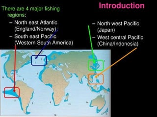
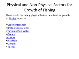
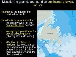
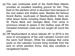
This document discusses the British school of modern geographical thought. It outlines several key founders and contributors, including Halford Mackinder who formulated the heartland theory of geopolitics. It also discusses Patrick Geddes and his concepts of region and conurbation. Later contributors applied more quantitative and statistical analysis, like Richard Chorley and Peter Haggett who advanced models and theories using new techniques. In conclusion, the document traces how the British school evolved from early environmental determinism to incorporate more nuanced regional and inter-regional analysis, and eventually quantitative and positivist approaches.
This document discusses the differences between systematic and regional geography. Systematic geography studies one geographic topic or phenomenon globally, such as climatology or soils. Regional geography analyzes all geographic aspects of a particular place or region. While these were initially seen as separate approaches, geographers now recognize them as interconnected and complementary. The regional provides real-world examples and data to test theories from systematic geography, while systematic studies form rules and laws that can be applied to different regions. Together, they provide a more comprehensive understanding of geography.
This document outlines 9 fundamental concepts in geomorphology. It introduces geomorphology as the description and interpretation of earth's landforms. Some key concepts discussed are:
- The principle of uniformitarianism, which states that geological processes have operated consistently over time, though intensities may have varied.
- Geological structure strongly influences landform evolution and is reflected in topography.
- Individual geomorphic processes leave distinctive imprints and develop characteristic landform assemblages.
- Landforms develop through successive stages as erosional processes act on the earth's surface over time.
- Most of the world's topography developed during the Pleistocene and is influenced by past geological and climatic changes.
POPULATION GEOGRAPHY vs. DEMOGRAPHY
Preface of the terms.
Variability between the terms.
Skills to the study of Population Geography.
Importance of Demographics and its Data.
Factors examined by the field of demography.
Demographic Transition Theory (DTT).
Population Pyramid.
Association between the terms.
Stats / Graphs of India – with referencing to Population and Demography.
India’s population projection.
Bibliography.
This document discusses different types of thematic maps including choropleth maps, chorochromatic maps, choroschematic maps, dot distribution maps, cartograms, cadastrel maps, topographic maps, contour lines, and isopleth maps. It provides brief definitions and descriptions of each type of map. For example, it explains that a choropleth map uses shading or patterns to represent statistical data within geographic areas, a chorochromatic map uses color variations to represent categorical data regions, and a topographic map shows natural and artificial features using contour lines of equal elevation.
Population geography is the study of human population distribution and dynamics across different regions. It examines how numbers, characteristics, and movement of people vary based on environmental and cultural factors in an area. G.T. Trewartha is considered the father of population geography for establishing it as a distinct subfield in the 1950s and proposing what topics it encompasses. Population geography analyzes absolute population sizes, qualities like age and sex ratios, and dynamics including fertility, mortality, and migration patterns. It also relates population trends to variables like resources, development levels, and government policies. As an interdisciplinary field, it interconnects with demography, sociology, economics, history and other social sciences.
The primary aim of studying settlement geography is to acquaint with the spatial and structural characteristics of human settlements under varied environmental conditions.
This document provides information about the Dark Ages in Europe and the influence of geography on medieval society. It begins with questions for students to answer about the Dark Ages and European geography. It then defines the Dark Ages as the period from 476-1000 CE after the fall of Rome when Europe lacked leadership. Historians call it "Dark" due to lack of information and little cultural advancement. The document describes the different climates and crops of Northern and Southern Europe and how abundant resources like forests and farmland allowed small self-sufficient kingdoms to form. Geography shaped medieval society by providing good conditions for farming and production across Europe.
Trewartha approach in studying population geography. Sushanta Gupta
According to Trewartha, Population is the point of reference from which all the other elements are observed and from which they all, singly and collectively, derive significance and meaning. It is population which furnishes the focus
The document discusses six approaches to political geography: power analysis, historical, morphological, functional, behavioral, and systematic. It focuses on defining and explaining the functional and behavioral approaches. The functional approach studies how political areas function and interact internally and externally. It examines centralizing and decentralizing forces. The behavioral approach identifies space as an independent variable and studies how human behavior is influenced by territorial boundaries and patterns.
The economy of the world is fast changing during the recent years.
The changes in primary, secondary and tertiary stages are dynamic in nature.
In view of this, the objectives of studying economic geography are to integrate several factors of economic development to acquaint with the dynamic aspects of the Scenario. This module is about basics of economic geography.
Settlement geography is a branch of human geography that deals with how human populations are distributed on Earth and how settlements form and change over time. It examines characteristics like population size, layout, functions, and relationship to the surrounding environment. Originally focused on describing existing settlement patterns, the field has evolved to use remote sensing and modeling to analyze changes and plan more sustainable development. Settlement geography considers factors influencing where and how people first formed settlements and how they have expanded, as well as issues around rapid urbanization and strategies for improving rural and urban livability. While its scope has adapted over time, the core focus remains understanding the physical attributes of settlements and their interactions with social and environmental conditions.
Scope and content of population geographyMithun Ray
This document provides an overview of population geography as an academic discipline. It discusses key thinkers who established population geography as a subfield of human geography. It also outlines major topics of focus for population geography, including population size and distribution, dynamics of growth, and qualities/characteristics of populations. The document contrasts population geography with related fields like demography and population studies, noting geography's emphasis on spatial variation and relationships between places. It also briefly discusses the development of population geography as a topic of study in India.
- A morphogenetic region is a region where the dominant geomorphic processes, under certain climatic conditions, contribute to distinctive landscape characteristics that contrast with other regions formed under different climates.
- The concept is based on the idea that each climate produces characteristic landforms through its influence on processes like weathering, erosion, and runoff.
- Morphogenetic regions are defined by identifying major climatic/zoogeographical regions and the diagnostic landforms within them that reflect the dominant geomorphic processes operating under those particular climatic conditions.
The document discusses the concept of paradigms in geography. It defines a paradigm as a set of beliefs and assumptions that shape how one views reality in a particular field. It notes that major paradigm shifts have occurred in geography, such as Ptolemy's geocentric model being replaced by Copernicus' heliocentric model. The document outlines several paradigms that have influenced geography, such as the romantic analytical paradigm of early geographers like Ritter and Humboldt, and the political geography paradigm associated with the rise of nation states. It also mentions that geography currently lacks complete revolutions and paradigms shifts, but different schools of thought are seeking new paradigms to better understand geographical regions.
The study deals different terms, concept, definitions, theories of population, census statistics, maps and diagrams for representations of demographic data. You read it carefully until the last.
Postmodern geography emerged as a reaction to modernism and its emphasis on grand theories and rational explanations of human behavior and society. Postmodernism rejects the idea of objective truth and universal reason, instead emphasizing particular perspectives and pluralism. It first appeared in fields like architecture and literature before being incorporated into geography starting in the 1970s. Postmodern geographers reject meta-narratives and focus on specific contexts and differences in space. They also aim to restore the importance of geography by emphasizing how spatial factors shape social and economic processes. However, postmodern geography has been criticized for potentially promoting intellectual nihilism and for deemphasizing important concepts like social class.
1. DEFINITIONS OF OCEANOGRAPHY:-
2. Branches of oceanography
3. Nature of Oceanography
4. A Geographical approach into Oceanography
5. Importance of Oceanography
6. Contribution of oceanographers
7. DEVELOPMENT OF MODERN OCEANOGRAPHY
There are 10 major cultural realms in the world according to H. Robinson's classification system. These include the Polar region, European region, Anglo-American region, Latin American region, Dry region, African region, Oriental region, and Australia-New Zealand region. Each cultural realm is characterized by shared linguistic, religious, and other cultural traits as well as similarities in climate, occupation, and level of development.
Environmental determinism and possibilismAmstrongofori
Human-environment relationships involve how people use and are limited by their environment. There are three main aspects of this relationship:
1) Humans depend on the environment for survival.
2) Humans adapt to environmental conditions.
3) Humans modify their environment.
Alexander von humboldt by haroon khan bazai uobharoonkhan12345
A presentation on germen geographer one of the founder of modern geography ''alexander von Humboldt " by M Haroon khan bazai university of Baluchistan, Quetta
Geography is the study of the Earth and its features. It examines the relationship between the natural environment and human societies. Definitions of geography have evolved over time from focusing on describing the physical Earth, to emphasizing spatial distributions and relationships between places. Modern definitions see geography as interdisciplinary, studying both natural systems and human-environment interactions. Geography aims to understand patterns on Earth's surface and how they are linked to ecological and social processes.
This slide discusses about the core-periphery model given by John Friedmann. This model is basically a model of regional Development. You will able to learn about the core-periphery model very easily by this slide.
Theories and models for Regional planning and developmentKamlesh Kumar
This is a work on the major theories of Regional planning mainly consisting the work of Francois Perroux, Gunnar Myrdal, Albert O. Hirschman, Walter Whitman Rostow and John Friedman.
Von thunen’s model of agricultural land useThe Urban Unit
This presentation is based on a agricultural land use model around the city. This is the theory of urban Geography it describe the agricultural pattern and how should the agricultural activities perform around the city. basically this Model was put forwarded before industrialization and when there was no roads networks and this Model is not applicable in real word but is gives great ideas for developing new towns and cities.
I’m professional presentation maker . These presentations are for sale for 20$ each, if required you can contact me on my gmail id bestpptmaker@gmail.com and you can also suggest me topics for your required presentations
Traditional food production is unable to feed the world's growing population. Marine resources provide food but are under threat. The document discusses major commercial fisheries and species, noting that 500 species are caught commercially by some 200 million people worldwide. It outlines threats like overfishing, bycatch, and habitat degradation threatening fisheries. Sustainable management, aquaculture, and protected areas are proposed as solutions to support marine food sources and livelihoods into the future.
Traditional food production is unable to feed the world's growing population. Marine resources provide food but are under threat. The document discusses major commercial fisheries and species, noting that 500 species are caught commercially by some 200 million people worldwide. It outlines issues like overfishing, bycatch, and mismanagement that threaten fisheries. Sustainable management, aquaculture, and protected areas are proposed as solutions to support marine food sources and alleviate problems of hunger.
This document discusses fishing industries in various regions and countries. It provides information on conditions that favor fishing industry development, types of fish, and fishing methods. Specifically, it summarizes fishing in Norway and Japan. Fishing is well developed in Norway due to factors like a continental shelf providing shallow waters and plankton, an indented coastline with harbors, ocean currents bringing food and favorable temperatures, limited other natural resources, and advanced fishing technologies and transportation. Japan also has a strong fishing industry facilitated by conditions like a broad continental shelf with ideal plankton growth, many inlets for fishing and ports, traditional seafaring experience, mountainous land unsuitable for agriculture, industrial technologies, and reliable domestic and international markets for fish.
This document discusses protecting aquatic biodiversity and managing fisheries sustainably. It begins by providing background on protecting whales through international agreements and moratoriums. Examples are then given of threats like overfishing, pollution, invasive species, and habitat loss negatively impacting aquatic species. The document advocates for establishing marine protected areas and reserves, reducing subsidies, and improving monitoring to better manage fisheries. Sustainable approaches like aquaculture and consumer awareness are also discussed.
History of the pacific sardine fishery and itsRobin Shin
The document provides a history of the Pacific sardine fishery, which underwent periods of boom and bust due to natural population fluctuations exacerbated by overfishing. The fishery grew rapidly in the early 20th century to meet wartime demand but collapsed in the 1940s when populations declined naturally amid continued high fishing pressure. Regulations were implemented in the 1970s during a period of low abundance, and the fishery has since fluctuated with sardine population cycles that are influenced by ocean temperature variations. Recent landings have declined sharply from 2007-2015 and the fishery was closed in 2015-2017 when biomass fell below sustainable levels.
The document provides an overview of the geography and regions of Canada. It discusses the 8 geographic regions of Canada, including the Cordillera Region in western Canada, the Interior Plains, the Canadian Shield, the Innuitian Region in northern Canada, the Arctic Lowlands, the St. Lawrence Lowlands in southern Ontario and Quebec, and others. It provides details on the climate, landscape, industries, and populations of several of these key regions.
Fisheries Management Plan for the Atlantic Bonito, Sarda sarda (Bloch, 1793) ...Christopher Kalloo
This document outlines a fisheries management plan for the Atlantic bonito (Sarda sarda) in Trinidad and Tobago. It provides information on the species, including that it is a migratory tuna found in coastal waters that feeds on smaller fish and invertebrates. It describes the Atlantic bonito fishery, which has declined in recent decades. Key threats include lack of data and misidentification. The management strategies proposed include improving legislation, data collection, research, and public education to better manage this important fishery.
Gulf Nova Scotia, Harbour Authority TriviaPeggy Thompson
This document provides information about a Gulf Nova Scotia Harbour Authority training session. It discusses the Gulf of St. Lawrence region, including historical details on European settlement and fishing industries. It also provides statistics on Gulf Nova Scotia's lobster licenses, harbours, dredging costs, and fish landings. The training session aimed to educate harbour managers and staff on topics relevant to managing fishing harbours in the Gulf Nova Scotia area.
A general evaluation of the shark fishery globally, with a closer look at the...Christopher Kalloo
This document provides an overview of the global shark fishery and focuses specifically on the shark fishery in Trinidad and Tobago. It discusses the commercial importance of sharks globally and identifies threats to shark populations like overfishing. It analyzes catch data and describes the artisanal and industrial fisheries that catch sharks in Trinidad and Tobago, noting a decline in reported landings. It also lists several shark species found in the waters of Trinidad and Tobago and their conservation status.
Lesson 4 Efforts to increase food production - Fishing In BruneiMs Geoflake
Fishing is an important industry in Brunei, as fish consumption is high at 47kg per person annually. However, about 50% of fish needs to be imported. Fishing provides income, protein, and jobs for boat building and net making. The main fishing areas are Brunei Bay, South China Sea, and inland waters. Methods include drift nets, trawling, traps, and cast nets. Issues facing the industry include overfishing, pollution, and destructive practices. The government is working to improve the industry through fish farms, artificial reefs, training, and collaboration. Common fish and seafood caught include anchovies, snapper, pomfret, shrimp, and crab.
1) Japan is the largest consumer of fish in the world, eating 7.5 billion tons per year. China has the largest fishing industry and catches the most fish, followed by Peru, Chile, Russia, and the United States.
2) Some of the richest fishing grounds in the world include the Sulu Sea along Palawan in the Philippines, the Visayan Sea in the Philippines, and the Northwest Pacific region.
3) Fishing industries are classified into inland fisheries in freshwater, coastal fisheries near shore, and offshore or deep sea fisheries in open ocean waters.
The New England colonies consisted of New Hampshire, Massachusetts, Connecticut, and Rhode Island. The climate was colder than other regions due to its northern location, which prevented diseases but also caused severe winters that killed people. The geography was mostly hilly with rocky soil unsuitable for farming, so the economy depended on natural resources like fish, whales, trees, and furs. Shipbuilding, rum production from molasses, and the triangular slave trade were important economic activities. Towns focused on religion, especially Puritanism, and did not tolerate other faiths. Most residents lived in villages and worked small nearby farms or trades.
- The article discusses the Canadian fisheries minister defending the country's seal hunting industry against criticism from animal welfare groups.
- The minister argues that the groups spread misinformation about the hunt and use emotional images of seal pups to raise money. She says Canada hasn't hunted seal pups for decades.
- The minister is trying to promote seal meat and products to counter campaigns against the Canadian fishing industry. However, the European Parliament banned seal products, which could impact this year's hunt.
- Canada is looking for new international markets for seal products while continuing to make the case for seal hunting domestically.
This document summarizes the Redwood Creek watershed and coastal lagoon area in northern California. It encompasses Redwood National and State Parks, which contain 41,000 acres of ancient coast redwood forest and are a World Heritage Site. The area also includes streams, lagoons, beaches, and diverse plant and animal life. It discusses the natural resources and cultural history of the region, as well as ongoing conservation efforts and challenges such as effects of timber harvesting and development. Partners are working to protect habitat, restore ecosystems, and balance land use in this ecologically and culturally significant area.
The oceans provide many valuable resources for humans, including fish as a key source of protein. However, overfishing due to improved fishing technologies and growing demand has led to declining fish stocks. Conservation of fisheries is challenging due to factors like fish moving across boundaries, illegal fishing, and lack of enforcement. While some measures have helped certain species like whales, overall conservation efforts have had only a minor impact on reducing overfishing and allowing fish populations to recover.
Elevate Your Nonprofit's Online Presence_ A Guide to Effective SEO Strategies...TechSoup
Whether you're new to SEO or looking to refine your existing strategies, this webinar will provide you with actionable insights and practical tips to elevate your nonprofit's online presence.
CapTechTalks Webinar Slides June 2024 Donovan Wright.pptxCapitolTechU
Slides from a Capitol Technology University webinar held June 20, 2024. The webinar featured Dr. Donovan Wright, presenting on the Department of Defense Digital Transformation.
Level 3 NCEA - NZ: A Nation In the Making 1872 - 1900 SML.pptHenry Hollis
The History of NZ 1870-1900.
Making of a Nation.
From the NZ Wars to Liberals,
Richard Seddon, George Grey,
Social Laboratory, New Zealand,
Confiscations, Kotahitanga, Kingitanga, Parliament, Suffrage, Repudiation, Economic Change, Agriculture, Gold Mining, Timber, Flax, Sheep, Dairying,
Information and Communication Technology in EducationMJDuyan
(𝐓𝐋𝐄 𝟏𝟎𝟎) (𝐋𝐞𝐬𝐬𝐨𝐧 2)-𝐏𝐫𝐞𝐥𝐢𝐦𝐬
𝐄𝐱𝐩𝐥𝐚𝐢𝐧 𝐭𝐡𝐞 𝐈𝐂𝐓 𝐢𝐧 𝐞𝐝𝐮𝐜𝐚𝐭𝐢𝐨𝐧:
Students will be able to explain the role and impact of Information and Communication Technology (ICT) in education. They will understand how ICT tools, such as computers, the internet, and educational software, enhance learning and teaching processes. By exploring various ICT applications, students will recognize how these technologies facilitate access to information, improve communication, support collaboration, and enable personalized learning experiences.
𝐃𝐢𝐬𝐜𝐮𝐬𝐬 𝐭𝐡𝐞 𝐫𝐞𝐥𝐢𝐚𝐛𝐥𝐞 𝐬𝐨𝐮𝐫𝐜𝐞𝐬 𝐨𝐧 𝐭𝐡𝐞 𝐢𝐧𝐭𝐞𝐫𝐧𝐞𝐭:
-Students will be able to discuss what constitutes reliable sources on the internet. They will learn to identify key characteristics of trustworthy information, such as credibility, accuracy, and authority. By examining different types of online sources, students will develop skills to evaluate the reliability of websites and content, ensuring they can distinguish between reputable information and misinformation.
How to Manage Reception Report in Odoo 17Celine George
A business may deal with both sales and purchases occasionally. They buy things from vendors and then sell them to their customers. Such dealings can be confusing at times. Because multiple clients may inquire about the same product at the same time, after purchasing those products, customers must be assigned to them. Odoo has a tool called Reception Report that can be used to complete this assignment. By enabling this, a reception report comes automatically after confirming a receipt, from which we can assign products to orders.
4. Physical and Non-Physical Factors for
Growth of Fishing
There could be many physical factors involved in growth
of Fishing industry
•Continental Shelf
•Broken Coastal Lines .
•Turbulent Sea Water
•Ocean-
currents
•Plankton
•Climate
• Forest
5. Non-Physical Factors
There are many factors that can be applied for increase
in fishing production. Some of them are as follow.
•Capital
•Cheap Labor
• Latest equipment
• Latest ports
•Modern means
•Modern Preservatory System
• Demand
6. Fishing Grounds of the World
Fishing Grounds in North-East Atlantic:
Fishing Grounds in North-West Atlantic:
Fishing Grounds in the North-East Pacific:
Fishing Grounds in the North-West Pacific:
7.
8.
9. (a) The vast continental shelf of the North-West Atlantic
provides an excellent breeding ground for fish. They
feed on the plankton which is abundant here because of
the cool waters and shallow seas. Besides the famous
Grand Banks, south-east of Newfoundland, there are
other lesser banks including Green Bank, Sable Bank,
St. Pierre Bank and Georges Bank. Fish come in
enormous shoals to spawn in the shallow seas off the
Canadian-American coast and are caught all round the
year.
(b) Off Newfoundland at about latitude 45° to 55°N is the
zone of convergence of the cold Labrador Current and
the warm Gulf Stream. While the icebergs that come
south on the Labrador Current bring minerals from the
land on which plankton thrive, they also constitute a
navigational hazard.
10. (c) Lack of natural resources on land has driven the people
to the sea. There are few minerals, agricultural land is
restricted and the growing season is short.
(d)The New England states were noted for their shipbuilding
industries. Ports such as Boston, Gloucester, Portland, and
Saint John’s and Halifax in Canada are still important for
shipbuilding. The timber also provides material for barrels
and boxes for the packing and preservation of fish.
(e) The cool temperate climate not only favors large-scale
commercial fishing, but also the preservation and storage of
fish. Modern canning and refrigerating facilities accelerated
the fish export trade.