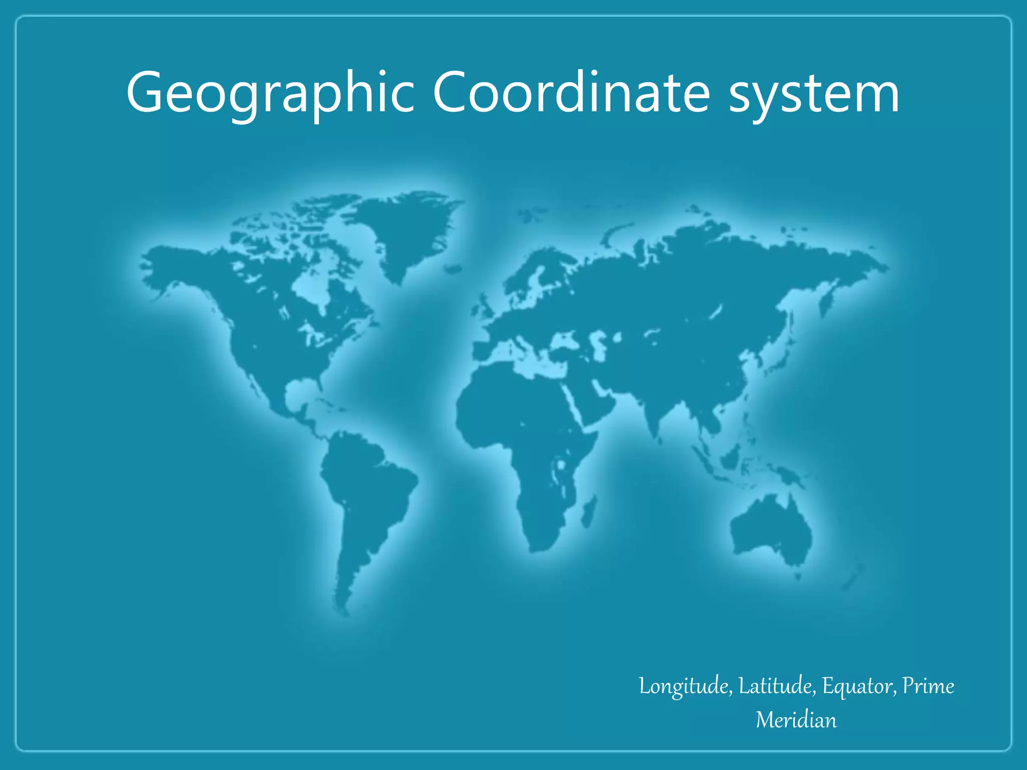
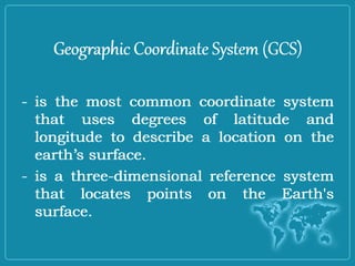
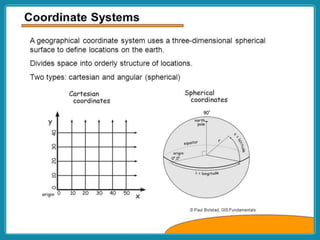
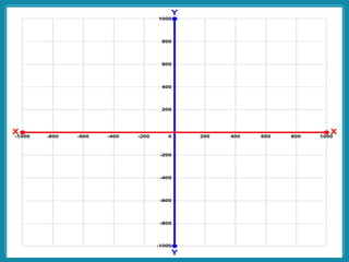
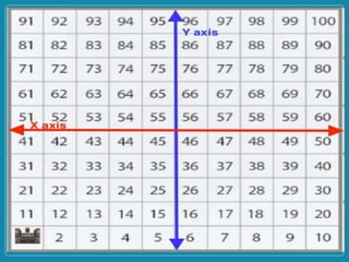
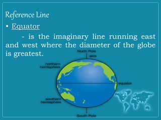
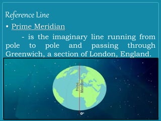
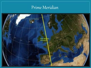
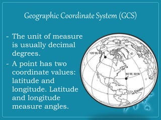
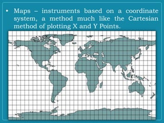
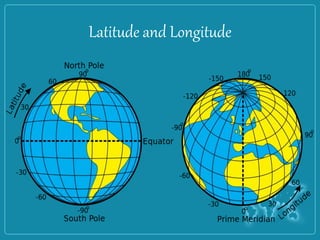
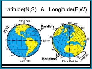
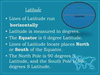
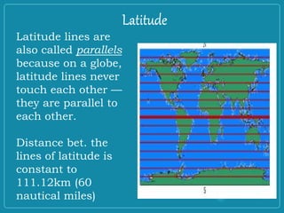
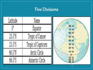
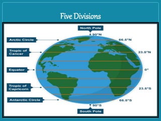
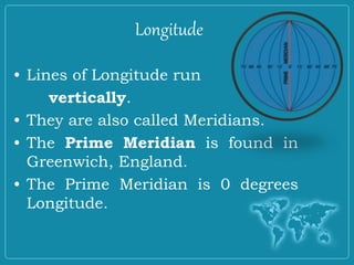
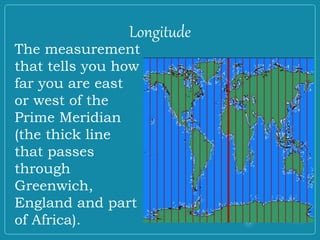
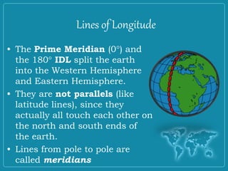
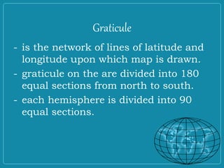
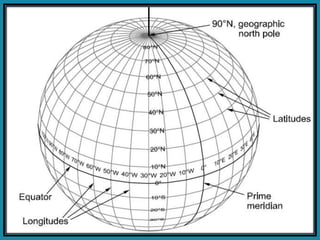
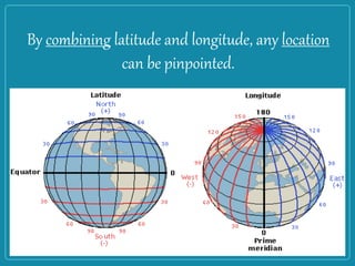
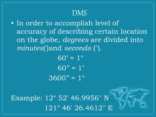
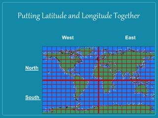
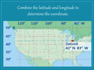
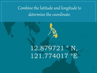
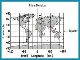
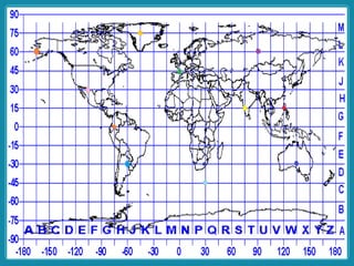
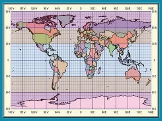
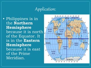
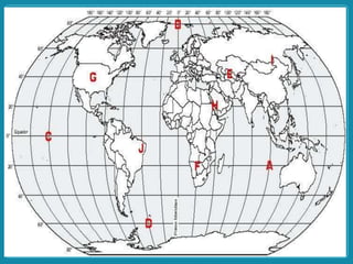
Geographic Coordinate system
Longitude, Latitude, Equator, Prime
Meridian
OBJECTIVES:
At the end of the lesson, the students
should be able to:
• differentiate latitude from longitude;
• describe the location of the Philippines
using latitude and longitude; and
• determine the location of different
places using coordinates.
Competencies:
• The Philippine Archipelago
(location)
• Location of different places
using a coordinate system
Coordinate System
- is a reference system used to
represent the locations of geographic
features, imagery, and locations within
a common geographic framework.
Coordinate System
Geographic Coordinate System (GCS)
- is the most common coordinate system
that uses degrees of latitude and
longitude to describe a location on the
earth’s surface.
- is a three-dimensional reference system
that locates points on the Earth's
surface.
Geographic Coordinate System (GCS)
- is the most common coordinate system
that uses degrees of latitude and
longitude to describe a location on the
earth’s surface.
- is a three-dimensional reference system
that locates points on the Earth's
surface.
Reference Line
• Equator
- is the imaginary line running east
and west where the diameter of the globe
is greatest.
Reference Line
• Prime Meridian
- is the imaginary line running from
pole to pole and passing through
Greenwich, a section of London, England.
Prime Meridian
- The unit of measure
is usually decimal
degrees.
- A point has two
coordinate values:
latitude and
longitude. Latitude
and longitude
measure angles.
Geographic Coordinate System (GCS)
• Maps – instruments based on a coordinate
system, a method much like the Cartesian
method of plotting X and Y Points.
Latitude and Longitude
Latitude
• Lines of Latitude run
horizontally
• Latitude is measured in degrees.
• The Equator is 0 degree Latitude.
• Lines of Latitude locate places North
or South of the Equator.
• The North Pole is 90 degrees N
Latitude, and the South Pole is 90
degrees S Latitude.
Latitude
Latitude
Latitude lines are
also called parallels
because on a globe,
latitude lines never
touch each other —
they are parallel to
each other.
Distance bet. the
lines of latitude is
constant to
111.12km (60
nautical miles)
Latitude
Five Divisions
Five Divisions
Longitude
• Lines of Longitude run
vertically.
• They are also called Meridians.
• The Prime Meridian is found in
Greenwich, England.
• The Prime Meridian is 0 degrees
Longitude.
Longitude
The measurement
that tells you how
far you are east
or west of the
Prime Meridian
(the thick line
that passes
through
Greenwich,
England and part
of Africa).
Lines of Longitude
• The Prime Meridian (0°) and
the 180° IDL split the earth
into the Western Hemisphere
and Eastern Hemisphere.
• They are not parallels (like
latitude lines), since they
actually all touch each other on
the north and south ends of
the earth.
• Lines from pole to pole are
called meridians
Graticule
- is the network of lines of latitude and
longitude upon which map is drawn.
- graticule on the are divided into 180
equal sections from north to south.
- each hemisphere is divided into 90
equal sections.
By combining latitude and longitude, any location
can be pinpointed.
• In order to accomplish level of
accuracy of describing certain location
on the globe, degrees are divided into
minutes(')and seconds (").
60’ = 1°
60’’ = 1’
3600’’ = 1°
Example: 12° 52' 46.9956'' N
121° 46' 26.4612'' E
DMS
Putting Latitude and Longitude Together
West East
North
South
Combine the latitude and longitude to
determine the coordinate.
Combine the latitude and longitude to
determine the coordinate.
12.879721 ° N,
121.774017 °E
Application:
• Philippines is in
the Northern
Hemisphere
because it is north
of the Equator. It
is in the Eastern
Hemisphere
because it is east
of the Prime
Meridian.
Evaluation:
I. Identification:
1.What do lines of Latitude and
Longitude combine to make?
2.Compare and Contrast Latitude
and Longitude.
3.What is 0 degrees Latitude?
4.What is 0 degrees Longitude?
III. Use world map or globe.
A. Identify the city nearest to the ff. coordinates.
1.280 N, 770 E
2.60 S, 1060 E
3.230 N, 820 W
B. Determine the coordinates of the ff. city.
1.Abu Dhabi 2. Bangkok 3. Buenos Aires

Coordinate Powerpoint.ppt

  • 1.
    Geographic Coordinate system Longitude,Latitude, Equator, Prime Meridian
  • 2.
    OBJECTIVES: At the endof the lesson, the students should be able to: • differentiate latitude from longitude; • describe the location of the Philippines using latitude and longitude; and • determine the location of different places using coordinates.
  • 3.
    Competencies: • The PhilippineArchipelago (location) • Location of different places using a coordinate system
  • 5.
    Coordinate System - isa reference system used to represent the locations of geographic features, imagery, and locations within a common geographic framework. Coordinate System
  • 6.
    Geographic Coordinate System(GCS) - is the most common coordinate system that uses degrees of latitude and longitude to describe a location on the earth’s surface. - is a three-dimensional reference system that locates points on the Earth's surface. Geographic Coordinate System (GCS) - is the most common coordinate system that uses degrees of latitude and longitude to describe a location on the earth’s surface. - is a three-dimensional reference system that locates points on the Earth's surface.
  • 17.
    Reference Line • Equator -is the imaginary line running east and west where the diameter of the globe is greatest.
  • 18.
    Reference Line • PrimeMeridian - is the imaginary line running from pole to pole and passing through Greenwich, a section of London, England.
  • 19.
  • 20.
    - The unitof measure is usually decimal degrees. - A point has two coordinate values: latitude and longitude. Latitude and longitude measure angles. Geographic Coordinate System (GCS)
  • 21.
    • Maps –instruments based on a coordinate system, a method much like the Cartesian method of plotting X and Y Points.
  • 22.
  • 24.
    Latitude • Lines ofLatitude run horizontally • Latitude is measured in degrees. • The Equator is 0 degree Latitude. • Lines of Latitude locate places North or South of the Equator. • The North Pole is 90 degrees N Latitude, and the South Pole is 90 degrees S Latitude. Latitude
  • 25.
    Latitude Latitude lines are alsocalled parallels because on a globe, latitude lines never touch each other — they are parallel to each other. Distance bet. the lines of latitude is constant to 111.12km (60 nautical miles) Latitude
  • 26.
  • 27.
  • 28.
    Longitude • Lines ofLongitude run vertically. • They are also called Meridians. • The Prime Meridian is found in Greenwich, England. • The Prime Meridian is 0 degrees Longitude.
  • 29.
    Longitude The measurement that tellsyou how far you are east or west of the Prime Meridian (the thick line that passes through Greenwich, England and part of Africa).
  • 30.
    Lines of Longitude •The Prime Meridian (0°) and the 180° IDL split the earth into the Western Hemisphere and Eastern Hemisphere. • They are not parallels (like latitude lines), since they actually all touch each other on the north and south ends of the earth. • Lines from pole to pole are called meridians
  • 31.
    Graticule - is thenetwork of lines of latitude and longitude upon which map is drawn. - graticule on the are divided into 180 equal sections from north to south. - each hemisphere is divided into 90 equal sections.
  • 33.
    By combining latitudeand longitude, any location can be pinpointed.
  • 34.
    • In orderto accomplish level of accuracy of describing certain location on the globe, degrees are divided into minutes(')and seconds ("). 60’ = 1° 60’’ = 1’ 3600’’ = 1° Example: 12° 52' 46.9956'' N 121° 46' 26.4612'' E DMS
  • 35.
    Putting Latitude andLongitude Together West East North South
  • 36.
    Combine the latitudeand longitude to determine the coordinate.
  • 37.
    Combine the latitudeand longitude to determine the coordinate. 12.879721 ° N, 121.774017 °E
  • 41.
    Application: • Philippines isin the Northern Hemisphere because it is north of the Equator. It is in the Eastern Hemisphere because it is east of the Prime Meridian.
  • 42.
    Evaluation: I. Identification: 1.What dolines of Latitude and Longitude combine to make? 2.Compare and Contrast Latitude and Longitude. 3.What is 0 degrees Latitude? 4.What is 0 degrees Longitude?
  • 44.
    III. Use worldmap or globe. A. Identify the city nearest to the ff. coordinates. 1.280 N, 770 E 2.60 S, 1060 E 3.230 N, 820 W B. Determine the coordinates of the ff. city. 1.Abu Dhabi 2. Bangkok 3. Buenos Aires

Editor's Notes

  • #16 25, 42, 78, 85, 93
  • #22 Map grid must be divided into sections to describe with an acceptable level of accuracy a specific location on the map.