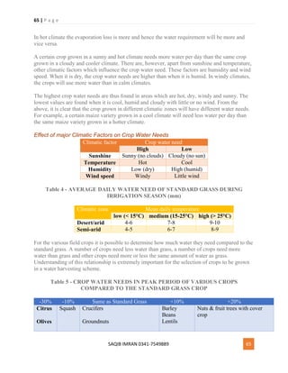
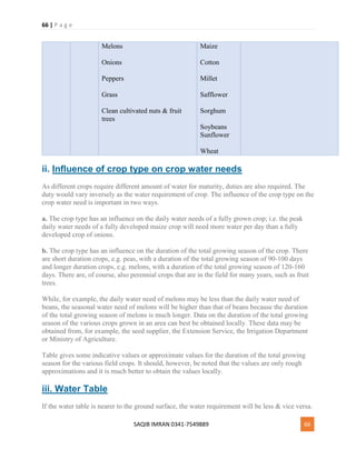
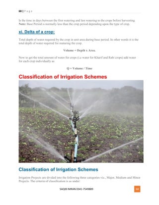
1 | P a g e
SAQIB IMRAN 0341-7549889 1
Assala mu alykum My Name is saqib imran and I am the
student of b.tech (civil) in sarhad univeristy of
science and technology peshawer.
I have written this notes by different websites and
some by self and prepare it for the student and also
for engineer who work on field to get some knowledge
from it.
I hope you all students may like it.
Remember me in your pray, allah bless me and all of
you friends.
If u have any confusion in this notes contact me on my
gmail id: Saqibimran43@gmail.com
or text me on 0341-7549889.
Saqib imran.
2 | P a g e
SAQIB IMRAN 0341-7549889 2
Water Resources and Irrigation Engineering
Lectures & Notes for Civil Engineers
Water Resource Engineering is a specific kind of civil engineering that involves the
design of new systems and equipment that help manage human water resources. Some
of the areas Water Resource Engineers touch on are water treatment facilities,
underground wells, and natural springs. Water Resources Engineering focuses on the
use and management of land and water resources in rural and urban watersheds.
Definition:
Irrigation is the controlled application of water to croplands. Its primary objective is to
create an optimal soil moisture regime for maximizing crop production and quality while
at the same time minimizing the environmental degradation inherent in irrigation of
agricultural lands. OR Irrigation is the application of water to the soil to supplement
natural precipitation and provide an environment that is optimum for crop production.
Well Irrigated crops produce more food.
Introduction & History of Irrigation Engineering
History of Irrigation Engineering
1. Ancient civilizations rose over irrigated areas
2. Egypt claims having the world's oldest dam, 108m long, 12m high, built 5,000 years ago
3 | P a g e
SAQIB IMRAN 0341-7549889 3
3. 6,000 years ago, Mesopotamia supported as many as 25 million people.
4. The same land today with similar population depends on imported wheat for food
Introduction to Irrigation Engineering
Irrigation is the controlled application of water to croplands. Its primary objective is to create an
optimal soil moisture regime for maximizing crop production and quality while at the same time
minimizing the environmental degradation inherent in irrigation of agricultural lands. Irrigation is
thus critical for food security in semi-arid and arid areas.
Irrigation has two primary objectives:
1. To supply the essential moisture for plant growth; &
2. To leach or dilute salts from the soil.
Irrigation water management deals with the frequency of irrigation, depth of water to be applied,
and measures to increase the uniformity of applications. Irrigation management should be a set of
practices designed to maximize efficiencies and minimize the labor and capital requirements of a
particular irrigation system.
Role of Civil Engineers in Irrigation Engineering
Irrigation is a cross cutting sector that involves civil engineers, hydrologists, environmental
experts, land surveyors, agricultural scientists and others, civil and irrigation engineers were
important for successful irrigation schemes
 The supply of water at farm turnout
 Water storage in Dams
 Water conveyance
 Flood control
 Supplying water WHEN needed and by the QUANTITY needed – irrigation scheduling
e.g in Weirs, Barrages
 Hydraulic Structures - Headworks, Cross Drainage works
Types of Canal Lining
4 | P a g e
SAQIB IMRAN 0341-7549889 4
There are varieties of linings that are available today but we will be discussing the following three:
1. Plain Cement Concrete Lining
2. Reinforced Cement Concrete Lining
3. Brick Lining
1. Plain Cement Concrete Lining
This lining is recommended for the canal in full banking. The cement concrete lining is widely
accepted. It can resist the effect of scouring and erosion very efficiently. The velocity of flow may
be kept above 2.5 m/s. It can eliminate completely growth of weeds. The lining is done by the
following steps:
(a) Preparation of sub-grade
The sub grade is prepared by ramming the surface properly with a layer of sand (about 15 cm).
Then slurry of cement and sand (1:3) is spread uniformly over the prepared bed.
(b) Laying of concrete
The cement concrete of grade M15 is spread uniformly according to the desired thickness,
(generally the thickness varies from 100mm to 150 mm). After laying, the concrete is tapped gently
until the slurry comes on the top. The curing is done for two weeks. As the concrete is liable to get
damaged by the change of temperature, the expansion joints are provided at appropriate places.
2. Brick Lining
This lining is prepared by the double layer brick flat soling laid with cement mortar (1:6) over the
compacted sub-grade. The first class bricks should be recommended for the work. The surface of
the lining is finished with cement plaster (1:3). The curing should be done perfectly.
This lining is always preferred for the following reasons:
 This lining is economical.
 Work can be done very quickly.
 Expansion joints are not required.
 Repair works can be done easily.
Bricks can be manufactured from the excavated earth near the site. However this lining has certain
disadvantages:
 It is not completely impervious.
 It has low resistance against erosion.
 It is not so much durable.
5 | P a g e
SAQIB IMRAN 0341-7549889 5
3. Reinforced Cement Concrete Lining
Sometimes reinforcement is required to increase the resistance against cracks and shrinkage
cracks. The reduction in the cracks results in less seepage losses. However this reinforcement does
not increase the structural strength of the lining. This reinforcement adds 10 to 15 percent to the
cost and for this reason steel reinforcement is usually omitted except for very particular situations.
Irrigation Efficiency - Definition and Its Types
Definition
The ratio of the amount of water available (output) to the amount of water supplied (input) is
known as Irrigation Efficiency. It is expressed in percentage.
Types of Irrigation Efficiency
The following are the various types of irrigation efficiencies:
(a) Water Conveyance Efficiency (ηc):
It is the ratio of the amount of water applied, to the land to the amount of water supplied from the
reservoir. It is obtained by the expression,
ηc = Wl Wr × 100 Where, ηc = Water conveyance efficiency Wl = Amount of water applied to
land Wr = Amount of water supplied from reservoir
(b) Water Application Efficiency (ηa):
It is the ratio of the water stored in root zone of plants to the water applied to the land. It is obtained
by the expression,
ηa = Wz Wl × 100 Where, ηa = Water application efficiency Wz = Amount of water stored in root
zone Wl = Amount of water applied to land
(c) Water Use Efficiency (ηu):
It is the ratio of the amount of water used to the amount of water applied. It is obtained by the
expression,
ηu = Wu Wl × 100 Where, ηu = Water use efficiency Wu = Amount of water used Wl = Amount
of water applied to land
6 | P a g e
SAQIB IMRAN 0341-7549889 6
(d) Consumptive use Efficiency (ηcu):
It is the ration of the consumptive use of water to the amount of water depleted from the root zone.
It is obtained by the expression, ηcu = Cu Wp × 100 Where,
ηcu = Consumptive use efficiency Cu = Consumptive use of water Wp = Amount of water depleted
from root zone
Methods of Improving and Factors Affecting
Duty of Water
Factors Affecting Duty of Water
The Factors Affecting Duty of Water in Irrigation are described below:
1. Soil Characteristics:
If the soil of the canal bed is porous and coarse grained, it leads to more seepage loss and
consequently low duty. If it consists of alluvial soil, the percolation loss will be less and the soil
retains the moisture for longer period and consequently the duty will be high.
7 | P a g e
SAQIB IMRAN 0341-7549889 7
2. Climatic Condition:
When the temperature of the command area is high the evaporation loss is more and the duty
becomes low and vice versa.
3. Rainfall:
If rainfall is sufficient during the crop period, the duty will be more and vice versa.
4. Base Period:
When the base period is longer, the water requirement will be more and the duty will be low and
vice versa.
5. Type of Crop:
The water requirement for various crops is different. So the duty varies from crop to crop.
6. Topography of Agricultural Land:
If the land is uneven the duty will be low. As the ground slope increases the duty decreases because
there is wastage of water.
7. Method of Ploughing:
Proper deep ploughing which is done by tractors requires overall less quantity of water and hence
the duty is high.
8. Methods of Irrigation:
The duty of water is high in case of perennial irrigation system as compared to that in inundation
irrigation system.
9. Water Tax:
If some tax is imposed the farmer will use the water economically thus increasing the duty.
Methods of Improving Duty:
Various methods of improving duty are:
(1) Proper Ploughing:
Ploughing should be done properly and deeply so that the moisture retaining capacity of soil is
increased.
8 | P a g e
SAQIB IMRAN 0341-7549889 8
(2) Methods of supplying water:
The method of supplying water to the agriculture land should be decided according to the field and
soil conditions. For example,
 Furrow method For crops sown ion rows
 Contour method For hilly areas
 Basin For orchards
 Flooding For plain lands
(3) Canal Lining:
It is provided to reduce percolation loss and evaporation loss due to high velocity.
(4) Minimum idle length of irrigation Canals:
The canal should be nearest to the command area so that idle length of the canal is minimum and
hence reduced transmission losses.
(5) Quality of water:
Good quality of water should be used for irrigation. Pollution en route the canal should be avoided.
(6) Crop rotation:
The principle of crop rotation should be adopted to increase the moisture retaining capacity and
fertility of the soil.
(7) Method of Assessment of water:
Particularly, the volumetric assessment would encourage the farmer to use the water carefully.
(8) Implementation of Tax:
The water tax should be imposed on the basis of volume of water consumption.
9 | P a g e
SAQIB IMRAN 0341-7549889 9
Advantages and Disadvantages of Canal Lining
Advantages of Canal Lining
1. It reduces the loss of water due to seepage and hence the duty is enhanced.
2. It controls the water logging and hence the bad effects of water-logging are eliminated.
3. It provides smooth surface and hence the velocity of flow can be increased.
4. Due to the increased velocity the discharge capacity of a canal is also increased.
5. Due to the increased velocity, the evaporation loss also can be reduced.
6. It eliminates the effect of scouring in the canal bed
7. The increased velocity eliminates the possibility of silting in the canal bed.
8. It controls the growth of weeds along the canal sides and bed.
9. It provides the stable section of the canal.
10. It reduces the requirements of land width for the canal, because smaller section of the canal
can be used to produce greater discharge.
11. It prevents the sub-soil salt to come in contact with the canal water. 12. It reduces the
maintenance cost for the canals.
Disadvantages of Canal Lining
1. The initial cost of the canal lining is very high. So, it makes the project very expensive with
respect to the output.
2. It involves many difficulties for repairing the damaged section of lining.
3. It takes too much time to complete the project work.
10 | P a g e
SAQIB IMRAN 0341-7549889 10
4. It becomes difficult, if the outlets are required to be shifted or new outlets are required to
be provided, because the dismantling of the lined section is difficult.
Sources of Irrigation Water - Ground Water &
Surface Water
The main source of irrigation water are:
Surface water:
It is found on the surface of the land. These include spring water, River water, lake water, etc. This
can be supplied to the field by weir (check dam) by gravity or by using pump. Check dam /wier/
system is used only when the source of water is from river, or spring water that starts from up
stream.
Where the slop of the source of water is greater than the slop of the field to be irrigated. Pumps
are used where the source of water for the field is at down stream (at lower altitude.) Here mostly
centrifugal type pumps are used.
Ground water:
Where these is shortage of surface water ground water is used for irrigation. This is supplied only
by using pumps.
11 | P a g e
SAQIB IMRAN 0341-7549889 11
Definition, Types & Comparison of Open & Pipe
Flow
Definition:
It is usually the flow in an Open Channels
Surface Flow:
The flow which is above the ground level is called surface flow.
Ground Flow:
The flow which is below the surface of the earth is called ground flow.
Hydraulics:
Deals with the study of surface water only
Ground Flow:
Deals with the surface as well as ground water water.
12 | P a g e
SAQIB IMRAN 0341-7549889 12
Differences between open and pipe flow
1. Open channel flow has a free water surface
2. Open channel flow is subjected to atmospheric pressure while pipe flow is not (when pipe
is full).
3. Open channel flow is not completely enclosed by boundaries, unlike pipe flow.
4. Open channel is always under the action of gravity, while pipe can be under gravity or may
flow due to some external pressure.
Partially filled pipes flow:partially filled pipes have flow which is not enclosed on all sides and
air is present above it so is under atmospheric pressure.
Open Channel flow (Free Gravity flow):
Open Chanel flow is that type of flow which is neither completely enclosed by the boundaries
nor is under any external pressure but gravity. It is subjected to atmospheric pressure. e.g. Rivers,
natural and artificial canals, streams, channels etc. Partially filled pipes flow is also an example
of open channel flow.
Types of open channel flow
Steady Flow:
For open channel, the flow is steady if the depth of flow does not change with respect to time at a
particular location or section.
Unsteady flow:
For open channel, the flow is unsteady if the depth of flow changes with respect to time at a
particular location or section.
Uniform flow:
For open channel flow, the flow is uniform if the depth of flow remains constant along a certain
length of the channel.
Non Uniform flow:
For open channel flow, the flow is non uniform if the depth of flow does not remains constant
along a certain length of the channel.
13 | P a g e
SAQIB IMRAN 0341-7549889 13
Gradually Varied flow:
If the depth of flow changes over a relatively long distance along the length of a channel, then
the flow is called gradually varied flow.
Rapidly Varied flow:
If the depth of flow changes over a relatively short distance along the length of a channel, then
the flow is called rapidly varied flow.
Why to study open channel flow: For construction of successful hydraulic
structures.
Open channel flow is difficult to deal with because:
 Difficult to secure reliable experimental data
 Are of different and irregular X-sections and shapes
Friction co-efficient is choiced by great uncertainty
Shapes, Types & Properties of Open Channels
14 | P a g e
SAQIB IMRAN 0341-7549889 14
Open channel can be said to be as the deep hollow surface having usually the top surface open to
atmosphere. Open channel flow can be said to be as the flow of fluid (water) over the deep
hollow surface (channel) with the cover of atmosphere on the top. Examples of open channels
flow are river, streams, flumes, sewers, ditches and lakes etc. we can be said to be as open
channel is a way for flow of fluid having pressure equal to the atmospheric pressure. While on
the other hand flow under pressure is said to be as pipe flow e.g. flow of fluid through the sewer
pipes.
Open-channel flow is usually categorized on the basis of steadiness. Flow is said to be steady
when the velocity at any point of observation does not change with time; if it changes from time
to time, flow is said to be unsteady. At every instant, if the velocity is the same at all points along
the channel, flow is said to be uniform; if it is not the same, flow is said to be non-uniform. Non-
uniform flow which is also steady is called as varied flow; non-uniform flow which is unsteady
is called as variable flow. Flow occurs from a higher to a lower concentration by aid of gravity.
Shapes of open channels
Usually the man made and artificial open channels don't have rectangular cross section. The most
common shapes of open channels are circular and trapezoidal.
Types of open channel
Open Channels are classified as:
1. Rigid boundary open channels
2. Loose boundary open channels
3. Prismatic open channels
Rigid boundary open channels can be said to be as the open channels with the non-changeable
boundaries. While on the other hand if open channel has the boundaries which changes due to
scouring action or deposition of sediments, such channels are said to be as loose boundary open
channels. The open channels in which shape, size of cross section and slope of the bed remain
constant are said to be as the prismatic channels. Opposite o these channels are non-prismatic
channels. Natural channels are the example of non-prismatic channels while man made open
channels are the example of prismatic channels.
Properties of Open Channels:
15 | P a g e
SAQIB IMRAN 0341-7549889 15
In open channels flow usually occur due to the slope of channel bottom and the slope of liquid
surface. The main difference in the open channel flow and pipe flow is that in pipe flow usually
the cross section of channel is fixed and confined while on the other hand open channel flow is
unconfined. Open channels flow is difficult to analyze than the pipe flow. That's why in open
channel flow measurement empirical approach is adopted. The velocity of flow in open channel
can be computed by help of Manning's formula:
V = 1/n x R0.66 x S0.5
In pipe flow the conduit (pipe for movement of fluid) usually completely fills with water for the
development of pipe pressure, while in the conduit which is partially filled can have open
channel flow. There is no restriction for the conduit in case of open channel flow to be
completely filled.
Factors influencing the flow in open channels:
1. Channel shape
2. Fluid depth
3. Fluid velocity
4. Slope of channel
Flow measurement in open channel
The most common method which is used for the measurement of flow in open channel is to
measure the height of the liquid as it passes over an obstruction (a flume or weir) in the open
channel. This is usually done by constructing hydraulic structures like weirs, notches and flumes
etc Manning approach can be used for flow measurement in open channels.
16 | P a g e
SAQIB IMRAN 0341-7549889 16
Management of Water Logging & Salinity in
Pakistan
Water logging and Salinity:
The irrigation system in Pakistan has brought great benefits to many people. Dependence on the
natural hydrological system has been minimized and new settlements in canal irrigated areas have
been established. However, the canal system has been accompanied by problems, which are
increasingly difficult to overcome.
Water logging and salinity are two of the outcomes of canal irrigation in Pakistan. When only
inundation canals were used, water for crops was only available during the summer season. A
balance was maintained between the precipitation and evapo-transpiration that kept the water-table
low. With the introduction of perennial canals, water was available throughout the year resulting
in a rise of the water-table. Salts in the soil also rise to the surface with the water-table.
The water on reaching the surface evaporates and the salts are deposited on the surface, rendering
the land unsuitable for farming. The rise of the water-table to the surface level is called water
logging and the appearance of salty patches is called salinity.
Management of Water Resources:
17 | P a g e
SAQIB IMRAN 0341-7549889 17
Ther is a scarce resource in Pakistan. Its storage, ibution and use have to be carefully managed in
order me Water Accord was not followed resulting in disputes between the provinces and a
decrease in the agricultural output. As Pakistan is predominancy an agricultural country, the
scarcity of water resources may affect Pakistan's economy negatively. order to conserve the scarce
water resources, the following steps should be taken; National priorities such as the maximisation
of agricultural production should be considered with regard to the distribution of water between
the provinces.
Sites for small dams should be developed to store surplus flow during the monsoon season. Small
dams are more cost effective and produce quick results compared with large dams because they
are constructed in a shorter period of time are cheaper to build and easy to maintain. In order to
avoid water loss from unlined canals, a crash program should be launched to line the canals with
cement. Fresh water sources like rivers and lakes should not be used as dumping sites of solid and
liquid waste. Natural fresh water lakes should be conserved to develop local water sources.
In Sindh, the Manchar, Kinjhar and Haleji lakes are the worst affected by pollution. Ground water
contamination should be prevented as far as possible by controlling the seepage of toxic waste into
the ground. A public education and information programme should be launched to influence the
attitudes of the people towards the need to conserve water because it is a diminishing natural
resource. The media, NGOs and educational institutions should take part in this programme.
Methods of Estimation of Consumptive Use of
Water
18 | P a g e
SAQIB IMRAN 0341-7549889 18
Consumptive water use is water removed from available supplies without return to a water
resource system (e.g., water used in manufacturing, agriculture, and food preparation that is not
returned to a stream, river, or water treatment plant).
To measure or estimation the consumptive use there are three main methods:
1. Direct Methods/Field Methods
2. Empirical Methods
3. Pan evaporation method
1. Direct Methods:
In this method field observations are made and physical model is used for this purpose. This
includes,
i. Vapour Transfer Method/Soil Moisture Studies
ii. Field Plot Method
iii. Tanks and Lysimeter
iv. Integration Method/Summation Method
v. Irrigation Method
vi. Inflow Outflow Method
1.1 Vapour Transfer Method:
In this method of estimation of water consumptive use, soil moisture measurements are taken
before and after each irrigation. The quantity of water extracted per day from soil is computed for
each period. A curve is drawn by plotting the rate of use against time and from this curve, the
seasonal use can be estimated. This method is suitable in those areas where soil is fairly uniform
and ground water is deep enough so that it does not affect the fluctuations in the soil moisture
within the root zone of the soil.
It is expressed in terms of volume i.e. Acre-feet or Hectare-meter
1.2 Field Plot Method:
We select a representative plot of area and the accuracy depends upon the representativeness of
plot (cropping intensity, exposure etc).It replicates the conditions of an actual sample field (field
plot). Less seepage should be there.
Inflow + Rain + Outflow = Evapotranspiration
The drawback in this method is that lateral movement of water takes place although more
representative to field condition. Also some correction has to be applied for deep percolation as it
cannot be ascertained in the field.
19 | P a g e
SAQIB IMRAN 0341-7549889 19
1.3 Tanks and Lysimeter:
In this method of measurement of consumptive use of water, a watertight tank of cylindrical shape
having diameter 2m and depth about 3m is placed vertically on the ground. The tank is filled with
sample of soil. The bottom of the tank consists of a sand layer and a pan for collecting the surplus
water. The plants grown in the Lysimeter should be the same as in the surrounding field. The
consumptive use of water is estimated by measuring the amount of water required for the
satisfactory growth of the plants within the tanks. Consumptive use of water is given by,
Cu = Wa - Wd
Where,
Cu = Consuptive use of water
Wa = Water Applied
Wd = Water drained off
Lysimeter studies are time consuming and expensive. Methods 1 and 2 are the more reliable
methods as compare to this method.
1.4 Integration Method:
In this method, it is necessary to know the division of total area, i.e. under irrigated crops, natural
native vegetation area, water surface area and bare land area. In this method, annual consumptive
use for the whole area is found in terms of volume. It is expressed in Acre feet or Hectare meter.
Mathematically,
Total Evapotranspiration = Total consumptive usex
Total Area Annual Consumptive Use = Total Evapotranspiration = A+B+C+D Where,
A = Unit consumptive use for each cropxits area
B = Unit consumptive use of native vegetation xits area
C = Water surface evaporationxits area
D = Bare land evaporationxits area
1.5 Irrigation Method:
In this method, unit consumption is multiplied by some factor. The multiplication values depend
upon the type of crops in certain area. This method requires an Engineer judgment as these factors
are to be investigated by the Engineers of certain area.
1.6 Inflow Outflow Method:
In this method annual consumptive use is found for large areas. If U is the valley consumptive use
its value is given by,
20 | P a g e
SAQIB IMRAN 0341-7549889 20
U = (I+P) + (Gs - Ge) - R
Where,
U = Valley consumptive use (in acre feet or hectare meter)
I = Total inflow during a year
P = Yearly precipitation on valley floor
Gs = Ground Storage at the beginning of the year
Ge = Ground Storage at the end of the year
R = Yearly Outflow
All the above volumes are measured in acre-feet or hectare-meter.
2. Empirical Methods:
Empirical equations are given for the estimation of water requirement. These are,
2.1 Lowry Johnson Method:
The equation for this method is,
U = 0.0015 H + 0.9 (Over specified)
U = Consumptive Use
H = Accumulated degree days during the growing season computed from maximum temperature
above 32 °F
2.2 Penman Equation:
According to this method,
U = ET = AH + 0.27 EaA - 0.27
ET = Evapotranspiration or consumptive use in mm Ea = Evaporation (mm/day)
H = Daily head budget at surface (mm/day)
H is a function of radiation, sunshine hours, wind speed, vapour pressure and other climatic
factors.
A = Slope of saturated vapour pressure curve of air at absolute temperature in °F
2.3 Hargreave’s Method:
It is a very simple method. According to this method,
Cu = KEp
21 | P a g e
SAQIB IMRAN 0341-7549889 21
Where,
Cu = Consumptive Use coefficient (varies from crop to crop)
Ep = Evapotranspiration K = Coefficient
Design of Precast Parabolic Channels in
Peshawar
Introduction to Project of Precast Parabolic Channels
 Canal irrigation system of Pakistan represents one of the largest system.
 Discrepancy feature is the conveyance losses (35 to 50%)
 Irrigation system of KPK (Province of Pakistan) is facing severe Operational problems
including water scarcity, water logging, and salinity.
 Reason was due to the traditional brick lining.
Steps to design Precast Parabolic Channels
The following steps are involved in the design of our selected water channel.
 Collection of field data.
 Using design software
 Obtaining the final design parameters
Site Selection
 Site selected was Syphon (Badabher, Peshawar, Pakistan)
 Selected channel was off taking from Warsak canal at RD 96+000 feet
22 | P a g e
SAQIB IMRAN 0341-7549889 22
 Name of channel Badabher Akkundi BalaKhel
 CCA 2000 Gareb (Full channel)
 Selected watercourse was earthen
 Wheat and maize were the prime crops of the area
Collection of field data
Instruments
 Common survey equipments
Methodology
 Measurement of Full supply level of the channel (FSL)
 Measurement of Bed level of channel
 Measurement of Full Supply Level at crest
 Measurement of Crest level of channel
 Measurement of FSL at RD 0+00
 Measurement of Bed level at 0+00
In addition to above following data was collected at each 30 meter interval of channel. FSL of
channel
 Bed level of channel
 Left bank (L/B) and Right bank (R/B) of channel
 Highest field elevation
 RD's of Nuccas recorded along the channel.
Using Design Software
 Super Calc 5
 DOS version
 Renowned software for designing channels
 INPUTS
 Bed reduced level
 HFL
 CCA
 Discharge (Q)
Conclusions
 Super Calc provides excellent graphical presentation
 MS Excel spreadsheet used for both Brick lining and PCPS
 PCPL much cheaper than brick lining
 9 drops provided
23 | P a g e
SAQIB IMRAN 0341-7549889 23
Construction of Open Wells
How to construct water wells?
24 | P a g e
SAQIB IMRAN 0341-7549889 24
A water well is a lot more than a drilled hole, but for many people, the above ground part of the
drilling process is the only part they see. A water well is a specially engineered hole in the ground;
For ground water monitoring, or for scientific research purposes, wells may be drilled in a way
that allows the specialists to closely examine the rock formations and take frequent water samples.
Augured wells and diamond core drilling are drilling techniques often used for scientific purposes.
Most home wells are drilled to 8 or 6 inches in diameter. Municipal or irrigation wells are likely
to be drilled at larger diameters, sometimes as much as 24 inches or more. The important tasks for
preparing a planning report of a water resources project would include the following:
1. Analysis of basic data like maps, remote sensing images, geological data, hydrologic
data, and requirement of water use data, etc.
2. Selection of alternative sites based on economic aspects generally, but keeping in mind
environmental degradation aspects.
o Studies for dam, reservoir, diversion structure, conveyance structure, etc.
o Selection of capacity.
o Selection of type of dam and spillway.
o Layout of structures.
o Analysis of foundation of structures.
o Development of construction plan.
o Cost estimates of structures, foundation strengthening measures, etc.
3. Studies for local protective works – levees, riverbank revetment, etc.
4. Formulation of optimal combination of structural and non-structural components (for
projects with flood control component).
5. Economic and financial analyses, taking into account environmental degradation, if any,
as a cost.
6. Environmental and sociological impact assessment.
25 | P a g e
SAQIB IMRAN 0341-7549889 25
What is Consumptive Use of Water and Factors
Affecting it
Definition:
It is the quantity of water used by the vegetation growth of a given area. It is the amount of water
required by a crop for its vegetated growth to evapotranspiration and building of plant tissues
plus evaporation from soils and intercepted precipitation. It is expressed in terms of depth of
water. Consumptive use varies with temperature, humidity, wind speed, topography, sunlight
hours, method of irrigation, moisture availability.
Mathematically,
Consumptive Use = Evapotranspiration = Evaporation + transpiration It is expressed in terms of
depth of water.
Factors Affecting the Consumptive Use of Water
26 | P a g e
SAQIB IMRAN 0341-7549889 26
Consumptive use of water varies with:
1. Evaporation which depends on humidity
2. Mean Monthly temperature
3. Growing season of crops and cropping pattern
4. Monthly precipitation in area
5. Wind velocity in locality
6. Soil and topography
7. Irrigation practices and method of irrigation
8. Sunlight hours
Types of Consumptive Water Use
Following are the types of consumptive use,
1. Optimum Consumptive Use
2. Potential Consumptive Use
3. Seasonal Consumptive Use
1. Optimum Consumptive Use:
It is the consumptive use which produces a maximum crop yield.
2. Potential Consumptive Use:
If sufficient moisture is always available to completely meet the needs of vegetation fully
covering the entire area then resulting evapotranspiration is known as Potential Consumptive
Use.
3. Seasonal Consumptive Use:
The total amount of water used in the evapo-transpiration by a cropped area during the entire
growing season.
27 | P a g e
SAQIB IMRAN 0341-7549889 27
Definition and Types of Cross Drainage Works
Definition:
A cross drainage work is a structure carrying the discharge from a natural stream across a canal
intercepting the stream. Canal comes across obstructions like rivers, natural drains and other
canals. The various types of structures that are built to carry the canal water across the above
mentioned obstructions or vice versa are called cross drainage works. It is generally a very costly
item and should be avoided by:
 Diverting one stream into another.
 Changing the alignment of the canal so that it crosses below the junction of two streams.
Types of cross drainage works
Depending upon levels and discharge, it may be of the following types:
Cross drainage works carrying canal across the drainage:
28 | P a g e
SAQIB IMRAN 0341-7549889 28
the structures that fall under this type are:
1. An Aqueduct
2. Siphon Aqueduct
Aqueduct:
When the HFL of the drain is sufficiently below the bottom of the canal such that the drainage
water flows freely under gravity, the structure is known as Aqueduct.
 In this, canal water is carried across the drainage in a trough supported on piers.
 Bridge carrying water
 Provided when sufficient level difference is available between the canal and natural and canal bed
is sufficiently higher than HFL.
29 | P a g e
SAQIB IMRAN 0341-7549889 29
Siphon Aqueduct:
In case of the siphon Aqueduct, the HFL of the drain is much higher above the canal bed, and
water runs under siphonic action through the Aqueduct barrels.
The drain bed is generally depressed and provided with pucci floors, on the upstream side, the
drainage bed may be joined to the pucca floor either by a vertical drop or by glacis of 3:1. The
downstream rising slope should not be steeper than 5:1. When the canal is passed over the drain,
the canal remains open for inspection throughout and the damage caused by flood is rare. However
during heavy floods, the foundations are susceptible to scour or the waterway of drain may get
choked due to debris, tress etc.
30 | P a g e
SAQIB IMRAN 0341-7549889 30
Cross drainage works carrying drainage over canal.
The structures that fall under this type are:
 Super passage
 Canal siphon or called syphon only
Super passage:
 The hydraulic structure in which the drainage is passing over the irrigation canal is known
as super passage. This structure is suitable when the bed level of drainage is above the
flood surface level of the canal. The water of the canal passes clearly below the drainage
 A super passage is similar to an aqueduct, except in this case the drain is over the canal.
 The FSL of the canal is lower than the underside of the trough carrying drainage water.
Thus, the canal water runs under the gravity.
 Reverse of an aqueduct
Canal Syphon:
 If two canals cross each other and one of the canals is siphoned under the other, then the
hydraulic structure at crossing is called “canal siphon”. For example, lower Jhelum canal
is siphoned under the Rasul-Qadirabad (Punjab, Pakistan) link canal and the crossing
structure is called “L.J.C siphon”
 In case of siphon the FSL of the canal is much above the bed level of the drainage trough,
so that the canal runs under the siphonic action.
 The canal bed is lowered and a ramp is provided at the exit so that the trouble of silting is
minimized.
 Reverse of an aqueduct siphon
 In the above two types, the inspection road cannot be provided along the canal and a
separate bridge is required for roadway. For economy, the canal may be flumed but the
drainage trough is never flumed.
31 | P a g e
SAQIB IMRAN 0341-7549889 31
Classification of aqueduct and
siphon aqueduct
Depending upon the nature of the sides of the aqueduct or siphon aqueduct it may be classified
under three headings:
Type I:
Sides of the aqueduct in earthen banks with complete earthen slopes. The length of culvert should
be sufficient to accommodate both, water section of canal, as well as earthen banks of canal with
aqueduct slope. Sides of the aqueduct in earthen banks, with other slopes supported by masonry
wall. In this case, canal continues in its earthen section over the drainage but the outer slopes of
the canal banks are replaced by retaining wall, reducing the length of drainage culvert.
Type II:
Sides of the aqueduct made of concrete or masonry. Its earthen section of the canal is discontinued
and canal water is carried in masonry or concrete trough, canal is generally flumed in this section.
32 | P a g e
SAQIB IMRAN 0341-7549889 32
Water Resources of Pakistan and Hydraulic
Structures in Pakistan
Water Budget of Pakistan
According to the United Nations' "UN World Water Development Report", the total actual
renewable water resources decreased from 2,961 m³ per capita in 2000 to 1,420 m³ per capita in
2005. A more recent study indicates an available supply of water of little more than 1,000 m³ per
person, which puts Pakistan in the category of a high stress country. In view of growing population,
urbanization and increased industrialization, the situation is likely to get worse.
In addition, increasing pollution and saltwater intrusion threaten the country's water resources.
About 36% of the groundwater is classified as highly saline.
In urban areas, most water is supplied from groundwater except for the cities of Karachi,
Hyderabad and a part of Islamabad, where mainly surface water is used. In most rural areas,
groundwater is used. In rural areas with saline groundwater, irrigation canals serve as the main
source of domestic water. Out of the 169,384 billion m³ of water which were withdrawn in 2000,
96% were used for agricultural purposes, leaving 2% for domestic and another 2% for industrial
use. This shows the significance of agriculture in the country. Pakistan still has the world's largest
33 | P a g e
SAQIB IMRAN 0341-7549889 33
interconnected & Continous irrigation system. In 1999-2000, the total irrigated area in Pakistan
was 181,000 km². Pakistan has one of the world’s largest gravity-flow irrigation systems, with:
1. Three reservoirs
2. 19 barrages
3. 12 river interlinking canals and
4. 59,200 kilometers of distribution canals.
More than 160,000 watercourses comprise the distribution network that takes water directly to the
farms. More than half of these watercourses are in Punjab—the largest of the country’s four
provinces and the biggest agricultural producer. The system commands a land area of 14.3 million
hectares, making it the backbone of Pakistan’s agriculture and contributes one-fourth of country’s
total gross domestic product (GDP). About 29% of water is generated through hydropower.
Major Barrages of Pakistan
Key facts
Barrage
Year of
Completion
Max. Design
Discharge
(cusecs)
No. of
Bays
Max. Flood
level from
floor(ft)
Total Design
Withdrawals for
Canal (cusecs)
Chashma 1971 1,100,000 52 37 26,700
Guddu 1962 1,200,000 64 26 -
Jinnah 1946 950,000 42 28 7,500
Kotri 1955 875,000 44 43.1 -
Sukkur 1932 1,500,000 54 30 47,530
Taunsa 1959 750,000 53 26 36,501
34 | P a g e
SAQIB IMRAN 0341-7549889 34
Crop Water Requirement in Irrigation and
Evaluation of Water Losses
It is defined as, "The quantity of water required by a crop in a given period of time for normal
growth under field conditions." It includes evaporation and other unavoidable wastes. Usually
water requirement for crop is expressed in water depth per unit area.
IRRIGATION WATER NEED = Crop water need — available rain fall
The first thing you need to consider when planning your garden is what growing zone you live in.
This is based on both the temperature range of your climate and the amount of precipitation. Take
a close look at the area in which you are going to plant your garden. If the ground tends to be very
moist, choose plants that can tolerate constantly wet soil, and even standing water.
If you live in an area that suffers from frequent droughts, however, select plants that can tolerate
going long periods without water, especially in light of the frequent watering restrictions imposed
on such areas. If you are lucky enough to live in an area that has a balanced climate, you have a
wider range of choices for your plants.
Low Water Requirement Plants
Plants that require low levels of water are often called drought tolerant. Drought-tolerant plants
can thrive in hot, dry conditions with very little water. They include both perennials and annuals.
Most drought-tolerant plants only have to be hand-watered when they are planted and while they
are establishing themselves. After that, they can be left to the natural cycle of the elements. Popular
35 | P a g e
SAQIB IMRAN 0341-7549889 35
drought tolerant trees include the red cedar. live oak, crape myrtle, and the windmill and saw
palmetto palm trees. All citrus trees are also drought tolerant. Many homeowners in areas prone to
drought, such as parts of the southern United States, use shrubs and ground covering vines as part
of their landscaping. These include Texas sage, orange jasmine and Chinese fountain grass. There
are not many perennial drought-tolerant plants, but amaryllis is one that is very popular, along with
the African iris. Popular drought-tolerant annuals include marigold, cosmos and the Dahlberg
daisy.
Mid-Level Water Requirement Crops
Most plants land in this range when it comes to water requirements. These plants do not need to
be watered every day, but they need to be watered when the soil has been dry for over a week or
two. Sometimes these plants are classified as plants lying in the "occasional water zone". These
include popular plants such as geraniums, most roses, wisteria, clematis and other vine plants,
sunflowers, spring flowering bulbs, and most flowering perennial shrubs. Note that flowering
annuals planted in containers will need watering at least once or twice a week, while annuals
planted in the ground will need watering less often.
High Water Requirement Plants
Some plants require large amounts of water. These plants typically grow in marshy areas or bogs,
or along the banks of rivers, streams and lakes. The soil for these plants should always be kept
moist. Standing water is not a concern for these plants, so you don't have to worry about root rot.
Perennials are especially good for wet areas because they don't have to be replanted year after year,
which can be difficult in marshy areas. Popular perennials for wet soil include iris plants, cannas,
bee balms, ferns, and bog salvia. Aquatic mint is a pleasant ground cover that likes wet soil. The
red osier dogwood does very well in wet conditions. Most annual flowering plants also do well in
constantly moist soil.
36 | P a g e
SAQIB IMRAN 0341-7549889 36
Water Requirement of Different Crops
Amount of water required by a crop in its whole production period is called water requirement.
The amount of water taken by crops vary considerably. What crops use more water and which
ones less.......
Crop Water Requirement
(mm)
Rice 900-2500
Wheat 450-650
Sorghum 450-650
Maize 500-800
Sugarcane 1500-2500
Groundnut 500-700
Cotton 700-1300
Soybean 450-700
Tobacco 400-600
Tomato 600-800
Potato 500-700
Onion 350-550
Chillies 500
Sunflower 350-500
Castor 500
Bean 300-500
Cabbage 380-500
Pea 350-500
Banana 1200-2200
Citrus 900-1200
Pineapple 700-1000
Gingelly 350-400
Ragi 400-450
Grape 500-1200
Irrigation Crop Water Requirement
This case study shows how to calculate the total water requirement for a command area (irrigation
blocks) under various crops, soil textures and conveyance loss conditions. In order to evaluate the
required irrigation gift for the entire command area a simple water balance has to be set-up. The
total water demand for each irrigation block and the crops in each block are calculated by summing
the following components:
 infiltration (percolation loss) through the soil (I)
 seepage (conveyance loss) through the channel (S)
 maximum evapo-transpiration of the crop (ETm)
37 | P a g e
SAQIB IMRAN 0341-7549889 37
In this exercise, the irrigation water requirement is calculated for a 10-day period during the harvest
stage.
Evaluation of Percolation loss (I)
The command area is divided in irrigation blocks. First, these irrigation blocks are crossed with
the soil texture map to determine the area of each soil texture class in each block. Percolation
losses differ per soil texture class so a table with the following percolation data is created:
Texture Percolation loss (mm/day)
Clay 4
Loam 12
Sandy clay 14
Clay loam 7
The percolation table is joined with the cross table to get the percolation for each soil texture class
in each block. The amount of water loss for each soil texture class per block is calculated with
a tabcalc statement. In order to get the total percolation loss per block the results of the previous
operation are aggregated.
Evaluation of Conveyance loss (S)
Conveyance losses are calculated in about the same way as the percolation losses. First, the map
with the irrigation blocks is crossedwith the channel distribution map. The conveyance loss per
meter channel length differs per channel type and is 0.2 m³ per day for clay channels and 0.01 m³
per day for concrete channels. A new table indicating water loss per channel type is created
and joined to the cross table. The amount of water loss for each type of channel per block is
calculated with a simple tabcalc formula. Finally the results are aggregated to evaluate the total
conveyance loss per irrigation block.
Evaluation of maximum evapo-transpiration (ETm)
Crop water requirements are normally expressed by the rate of evapotranspiration (ET). The
evaporative demand can be expressed as the reference crop evapotranspiration (ETo) which
predicts the effect of climate on the level of crop evapotranspiration. In this case study the ETo is
8 mm/day. Empirically-determined crop coefficients (kc) can be used to relate ETo to maximum
crop evapotranspiration (ETm) when water supply fully meets the water requirement of the crop.
The value of kc varies with crop and development stage. The kc values for each crop and
development stage are available in a table.
For a given climate, crop and crop development stage, the maximum evapotranspiration (ETm) in
mm/day of the period considered is:
ETm = kc * ETo
38 | P a g e
SAQIB IMRAN 0341-7549889 38
Maximum evapo-transpiration refers to conditions when water is adequate for unrestricted growth
and development under optimum agronomic and irrigation management. Maximum
evapotranspiration is calculated in this case study by crossing the irrigation block map with the
map that shows the different crop types in the command area, joining the cross table with the kc
table and by applying the maximum evapotranspiration formula with a tabcalc statement.
Water balance calculation (S+I+ETm)
The required irrigation gift for the entire command area is equal to the sum of water losses due to
infiltration through the soil (I), seepage through the channel (S) and maximum evapotranspiration
(ETm) for each block. The total amount of water requirement in harvest period for each block
is reclassified in irrigation classes using the following table:
Upper boundary Irrigation class
4000 1
6000 2
8000 3
10000 4
12000 5
14000 6
Finally, you will create a script to automate the calculation procedure. With the script, you can
easily calculate the water requirements for other growing stages.
39 | P a g e
SAQIB IMRAN 0341-7549889 39
Importance of Irrigation Engineering - Purposes,
Objectives and Benefits
 In the next 35-45- years, world food production will need to double to meet the demands
of increased population.
 90% of this increased food production will have to come from existing lands.
 70% of this increased food production will have to come from irrigated land
Purposes of Irrigation
 Providing insurance against short duration droughts
 Reducing the hazard of frost (increase the temperature of the plant)
 Reducing the temperature during hot spells
 Washing or diluting salts in the soil Softening tillage pans and clods
 Delaying bud formation by evaporative cooling
 Promoting the function of some micro organisms
Objectives of irrigation
 To Supply Water Partially or Totally for Crop Need
40 | P a g e
SAQIB IMRAN 0341-7549889 40
 To Cool both the Soil and the Plant
 To Leach Excess Salts
 To improve Groundwater storage
 To Facilitate continuous cropping
 To Enhance Fertilizer Application- Fertigation
Benefits of Irrigation
1. Increase in Crop Yield
2. Protection from famine
3. Cultivation of superior crops
4. Elimination of mixed cropping:
5. Economic development
6. Hydro power generation
7. Domestic and industrial water supply:
41 | P a g e
SAQIB IMRAN 0341-7549889 41
Evapotranspiration Measurement by Blaney
Criddle & Hargreaves
Blaney-Criddle Formula
The estimation of potential evapotranspiration is achieved by adopting empirical approaches,
such as the Thornthwaite equation, the Blaney-Criddle formula and the Hargreaves method, all
having as a requirement the availability of temperature data. The data set is made up of temperature
time series, obtained from gauging stations.
The potential evapotranspiration estimated for each station using the above-mentioned methods is
spatially integrated, in order to obtain the areal potential evapo-transpiration. The methods adopted
for the spatial integration of the point estimates are the Kriging method, the method of Inverse
Distance Weighting, the Spline method and the Thiessen method, using applications in a
Geographic Information System (GIS) with a spatial resolution of 200x200m2
.
u k (k ) (t x p) / 100
TR = kc kt) u = monthly consumptive use (inches)
42 | P a g e
SAQIB IMRAN 0341-7549889 42
kt = climatic coefficient
= 0.173 * t - 0.314
kc = crop growth stage coefficient
t = mean monthly air temperature (°F)
p = monthly percentage of annual daylight hours
Hargreaves Method of measurement of
Evapotranspiration
Originally developed in 1975
 solar radiation and temperature data inputs
 Updated in 1982 and 1985
 solar radiation estimated from extraterrestrial radiation, RA
 Grass reference ET
 May be used to compute daily estimates, but more accurate over longer time steps: 10-
days, monthly
ETo ? 0.0023(Tmax ? Tmin T ?17.8) R
ETo = grass reference ET (mm/day)
Tmax = maximum daily air temperature (°C)
Tmin = minimum daily air temperature (°C)
Tmean = mean daily air temperature = (Tmax + Tmin) / 2
Ra = extraterrestrial radiation (mm/day)
Ra (mm/day) = Ra (MJ/m2/day) / 2.45
 Simple, easy to use
 Data required—maximum and minimum air temperature
 Better predictive accuracy in arid climates than modified Blaney-Criddle
 Max-min temperature difference
 Extra-terrestrial radiation
 Underpredictal in windy or high advection conditions—requires local calibration
43 | P a g e
SAQIB IMRAN 0341-7549889 43
Methods & Techniques of Irrigation
There are three broad classes of irrigation systems:
1. Pressurized distribution
2. Gravity flow distribution
3. Drainage flow distribution.
1. Pressurized Distribution
The pressurized systems include sprinkler, trickle, and the array of similar systems in which water
is conveyed to and distributed over the farmland through pressurized pipe networks. There are
many individual system configurations identified by unique features (centre-pivot sprinkler
systems).
2. Gravity Flow Irrigation System
Gravity flow systems convey and distribute water at the field level by a free surface, overland flow
regime. These surface irrigation methods are also subdivided according to configuration and
operational characteristics.
44 | P a g e
SAQIB IMRAN 0341-7549889 44
3. Control of drainage flow irrigation System
Irrigation by control of the drainage system, sub-irrigation, is not common but is interesting
conceptually. Relatively large volumes of applied irrigation water percolate through the root zone
and become a drainage or groundwater flow. By controlling the flow at critical points, it is possible
to raise the level of the groundwater to within reach of the crop roots. These individual irrigation
systems have a variety of advantages and particular applications.
Irrigation systems are often designed to maximize efficiencies and minimize labour and capital
requirements. The most effective management practices are dependent on the type of irrigation
system and its design. For example, management can be influenced by the use of automation, the
control of or the capture and reuse of runoff, field soil and topographical variations and the
existence and location of flow measurement and water control structures.
Questions that are common to all irrigation systems are when to irrigate, how much to apply, and
can the efficiency be improved. A large number of considerations must be taken into account in
the selection of an irrigation system. These will vary from location to location, crop to crop, year
to year, and farmer to farmer.
Compatibility of the irrigation systems:
The irrigation system for a field or a farm must be compatible with the other existing farm
operations, such as land preparation, cultivation, and harvest.
 Level of Mechanization
 Size of Fields
 Cultivation
 Pest Control
 Topographic Limitations.
45 | P a g e
SAQIB IMRAN 0341-7549889 45
Restrictions on irrigation system selection due to topography include:
1. groundwater levels
2. the location and relative elevation of the water source,
3. field boundaries,
4. acreage in each field,
5. the location of roads
6. power and water lines and other obstructions,
7. the shape and slope of the field
Methods of Irrigation
Under gravity irrigation, water is distributed by means of open canals and conducts with out
pressure. Gravity irrigation methods are less expensive, but requires more skill and experience to
achieve re-scannable efficiency. This method also requires that the land to be irrigated should
have a flatter slope, other wise the cost of land leveling and preparation at times be come very
high. Gravity irrigation method. Includes furrow, boarder, basin, wild- flooding and corrugation.
1. Furrow irrigation
In this method of surface irrigation, water is applied to the field by furrow which are small canals
having a continuous our nearly uniform slope in the direction of irrigation. Water flowing in the
furrow into the soil spreads laterally to irrigate the area between furrows. The rate of lateral spread
of water in the soil depends on soil type.i.e. For a given time, water will infiltrate more vertically
and less laterally in relatively sandy soils than in clay soil.
Where the land grade is less than 1% in the direction of furrow, striate graded furrows may be
adapted. The grade can be as much as 2 to 3% depending on the soil type and the rainfall intensity,
which affects erosion. When field sloped is too steep to align the furrows down the slope, control
furrows which run along curved routed may be used. Spacing of furrows depends on the crop type
and the type of machinery used for cultivation and planting. Length of furrows depends largely on
permeability of the soil, the available labor and skill, and experiences of the irrigation. Flow
rates are related to the infiltration to the rate of the soil.
Longitudinal slope of furrow depends up on the soil type, especially its errodability and the
velocity of flow. Slope may be related to discharge as follows.
slope % 0.25 0.5 0.75 1.0 1.5 2.0
Qmax (m3/hr) 9.0 4.5 3.0 2.2 1.5 1.1
46 | P a g e
SAQIB IMRAN 0341-7549889 46
2. Boarder - strip Irrigation
The farms are divided into number of strips of 5 to 20 meters wide and 100 to 400 meters long.
Parallel earth bunds or levees are provided in order to guide the advancing sheet of water.
Recommended safe limits of longitudinal slope also depends on the soil texture:
Sandy loam to sandy soils 0.25 - 0.6%
Medium loam soils 0.2 - 0.4%
Clay to clay loam soils 0.05 - 0.2%
3. Basin irrigation
Large stream of water is applied to almost level and smaller unit of fields which are surrounded
by levees or bunds. The applied water is retained in the basin until it filtrates. Soil type, stream
size and irrigation depth are the important factors in determining the basin area.
Method of irrigation Type of Crop suited
Border strip method Wheat, Leafy vegetables, Fodders
Furrow method Cotton, Sugarcane, Potatoes
Basin method Orchard trees
4. Wild flooding
Water is applied all over the field especially, before plowing for soil that can't be plowed when
dry. Under closed conduit- there are two types of irrigation
1. Sprinkler
2. Drip irrigation
47 | P a g e
SAQIB IMRAN 0341-7549889 47
1. Sprinkler irrigation:
It is mostly used for young growth, to humid the atmosphere, for soil compaction( specially for
sandy loam soils before planting, for land having up and down slope and used to wash out plant
leaves especially in dusty area.
Sprinkler irrigation offers a means of irrigating areas which are so irregular that they prevent use
of any surface irrigation methods. By using a low supply rate, deep percolation or surface runoff
and erosion can be minimized. Offsetting these advantages is the relatively high cost of the
sprinkling equipment and the permanent installations necessary to supply water to the sprinkler
lines. Very low delivery rates may also result in fairly high evaporation from the spray and the
wetted vegetation. It is impossible to get completely uniform distribution of water around a
sprinkler head and spacing of the heads must be planned to overlap spray areas so that distribution
is essentially uniform
Advantages
 Economical to labour & uniform distribution.
2. Drip irrigation
This is used especially where there is shortage of water and salt problem. The drip method of
irrigation, also called trickle irrigation. The method is one of the most recent developments in
irrigation. It involves slow and frequent application of water to the plant root zone and enables the
application of water and fertilizer at optimum rates to the root system.
It minimizes the loss of water by deep percolation below the root zone or by evaporation from the
soil surface. Drip irrigation is not only economical in water use but also gives higher yields with
poor quality water.
Advantages
 No loss. of water because all water drops at root zone.
 No water logging and rise of water table at result salinity problems caused by this
irrigation type is almost nil.
 Uniform distribution of water.
 Good water management.
 Economical use of labour.
Choice and Selection of Irrigation Methods
Following are some reasons and factors which affect the selection of an irrigation system for a
specific area:
1. Compatibility of the irrigation system
2. Topographical characteristics of area
3. Economics and cost of the irrigation method
4. Soils
48 | P a g e
SAQIB IMRAN 0341-7549889 48
5. Water supply
6. Crops to be irrigated
7. Social influences on the selection of irrigation method
8. External influences
1. Compatibility of the irrigation system
The irrigation system for a field or a farm must be compatible with the other existing farm
operations, such as land preparation, cultivation, and harvest.
 Level of Mechanization
 Size of Fields
 Cultivation
 Pest Control
The use of the large mechanized equipment requires longer and wider fields. The irrigation systems
must not interfere with these operations and may need to be portable or function primarily outside
the crop boundaries (i.e. surface irrigation systems). Smaller equipment or animal-powered
cultivating equipment is more suitable for small fields and more permanent irrigation facilities.
2. Topographical characteristics of area
Topography is a major factor affecting irrigation, particularly surface irrigation. Of general
concern are the location and elevation of the water supply relative to the field boundaries, the area
and configuration of the fields, and access by roads, utility lines (gas, electricity, water, etc.), and
migrating herds whether wild or domestic
.
Field slope and its uniformity are two of the most important topographical factors. Surface
systems, for instance, require uniform grades in the 0-5 percent range.
Restrictions on irrigation system selection due to topography include:
 Groundwater levels
 the location and relative elevation of the water source
 field boundaries
 acreage in each field
 the location of roads
49 | P a g e
SAQIB IMRAN 0341-7549889 49
 power and water lines and other obstructions
 the shape and slope of the field
3. Economics and cost of the irrigation method
The type of irrigation system selected is an important economic decision. Some types of
pressurized systems have high capital and operating costs but may utilize minimal labour and
conserve water. Their use tends toward high value cropping patterns. Other systems are relatively
less expensive to construct and operate but have high labour requirements. Some systems are
limited by the type of soil or the topography found on a field. The costs of maintenance and
expected life of the rehabilitation along with an array of annual costs like energy, water,
depreciation, land preparation, maintenance, labour and taxes should be included in the selection
of an irrigation system.
Main costs include:
 Energy
 Water
 Land Preparation
 Maintenance
 Labor
 taxes
4. Soils
The soil's moisture-holding capacity, intake rate and depth are the principal criteria affecting the
type of system selected. Sandy soils typically have high intake rates and low soil moisture storage
capacities and may require an entirely different irrigation strategy than the deep clay soil with low
infiltration rates but high moisture-storage capacities. Sandy soil requires more frequent, smaller
applications of water whereas clay soils can be irrigated less frequently and to a larger depth. Other
important soil properties influence the type of irrigation system to use.
The physical, biological and chemical interactions of soil and water influence the hydraulic
characteristics and filth. The mix of silt in a soil influences crusting and erodibility and should be
considered in each design. The soil influences crusting and erodibility and should be considered
50 | P a g e
SAQIB IMRAN 0341-7549889 50
in each design. The distribution of soils may vary widely over a field and may be an important
limitation on some methods of applying irrigation water.
The soil type usually defines:
 Soil moisture-holding capacity
 The intake rate
 Effective soil depth
5. Water supply
The quality and quantity of the source of water can have a significant impact on the irrigation
practices. Crop water demands are continuous during the growing season. The soil moisture
reservoir transforms this continuous demand into a periodic one which the irrigation system can
service. A water supply with a relatively small discharge is best utilized in an irrigation system
which incorporates frequent applications. The depths applied per irrigation would tend to be
smaller under these systems than under systems having a large discharge which is available less
frequently. The quality of water affects decisions similarly. Salinity is generally the most
significant problem but other elements like boron or selenium can be important. A poor quality
water supply must be utilized more frequently and in larger amounts than one of good quality.
6. Crops to be irrigated
The yields of many crops may be as much affected by how water is applied as the quantity
delivered. Irrigation systems create different environmental conditions such as humidity,
temperature, and soil aeration. They affect the plant differently by wetting different parts of the
plant thereby introducing various undesirable consequences like leaf burn, fruit spotting and
deformation, crown rot, etc. Rice, on the other hand, thrives under ponded conditions.
Some crops have high economic value and allow the application of more capital-intensive
practices, these are called "cash crops" or Cash crop farming. Deep-rooted crops are more
amenable to low-frequency, high-application rate systems than shallow-rooted crops.
Cash Crop Water Requirement
Crop characteristics that influence the choice of irrigation system are:
51 | P a g e
SAQIB IMRAN 0341-7549889 51
 The tolerance of the crop during germination, development and maturation to soil salinity,
aeration, and various substances, such as boron
 The magnitude and temporal distribution of water needs for maximum production
 The economic value of the crop
7. Social influences on the selection of irrigation
method
Beyond the confines of the individual field, irrigation is a community enterprise. Individuals,
groups of individuals, and often the state must join together to construct, operate and maintain the
irrigation system as a whole. Within a typical irrigation system there are three levels of community
organization. There is the individual or small informal group of individuals participating in the
system at the field and tertiary level of conveyance and distribution. There are the farmer
collectives which form in structures as simple as informal organizations or as complex as irrigation
districts. These assume, in addition to operation and maintenance, responsibility for allocation and
conflict resolution. And then there is the state organization responsible for the water distribution
and use at the project level.
Irrigation system designers should be aware that perhaps the most important goal of the irrigation
community at all levels is the assurance of equity among its members. Thus the operation, if not
always the structure, of the irrigation system will tend to mirror the community view of sharing
and allocation.
Irrigation often means a technological intervention in the agricultural system even if irrigation has
been practiced locally for generations. New technologies mean new operation and maintenance
practices. If the community is not sufficiently adaptable to change, some irrigation systems will
not succeed.
8. External influences
Conditions outside the sphere of agriculture affect and even dictate the type of system selected.
For example, national policies regarding foreign exchange, strengthening specific sectors of the
local economy, or sufficiency in particular industries may lead to specific irrigation systems being
utilized. Key components in the manufacture or importation of system elements may not be
available or cannot be efficiently serviced. Since many irrigation projects are financed by outside
donors and lenders, specific system configurations may be precluded because of international
policies and attitudes.
52 | P a g e
SAQIB IMRAN 0341-7549889 52
Types of Tube Wells and Design of Strainer for
Tube Wells
1. Strainer type
2. Cavity type
3. Slotted type
Design of strainer or well screen for Tube Wells
In design, find its length, slot size, opening area, diameter and material requirements
a. Corrosion resistant
b. Strong enough to prevent collapse
c. Prevent excessive movement of sand into well
d. Minimum resistance to flow of water into the well
Materials used for Tube Well Construction
1. Zinc free brass
53 | P a g e
SAQIB IMRAN 0341-7549889 53
2. Stainless steel
3. Low carbon steel
4. High copper alloy
Advantages and Disadvantages of Surface
Irrigation Methods
Definition:
Surface irrigation is the introduction and distribution of water in a field by the gravity flow of
water over the soil surface. The soil acts as the growing medium in which water is stored and the
conveyance medium over which water flows as it spreads and infiltrates. Common surface
irrigation systems used are rill irrigation, furrow or border irrigation.
The term 'surface irrigation' refers to a broad class of irrigation methods in which water is
distributed over the field by overland flow. A flow is introduced at one edge of the field and covers
the field gradually.
The rate of coverage (advancement) is dependent on:
 the differences between the discharge onto the field and the accumulating infiltration into the soil.
Secondary factors include
54 | P a g e
SAQIB IMRAN 0341-7549889 54
1. field slope
2. surface roughness
3. geometry or shape of the flow cross-section.
The practice of surface irrigation is thousands of years old. It represents about 95 % of common
irrigation activity today. The first water supplies were developed from stream or river flows onto
the adjacent flood plain through simple check-dams and a canal to distribute water to various
locations. The low-lying soils served by these diversions were typically high in clay and silt content
(alluvium) and tended to be most fertile. With the advent of modern equipment for moving earth
and pumping water, surface irrigation systems were extended to upland areas and lands quite
separate from the flood plain of local rivers and streams.
Advantages of Surface Irrigation Methods
Surface irrigation offers a number of important advantages at both the farm and project level. The
gravity flow system is a highly flexible, relatively easily-managed method of irrigation.
1. Because it is so widely utilized, local irrigators generally have at least minimal
understanding of how to operate and maintain the system.
2. In addition, surface systems are often more acceptable to agriculturalists who appreciate
the effects of water shortage on crop yields since it appears easier to apply the depths
required to refill the root zone.
3. The second advantage of surface irrigation is that these systems can be developed at the
farm level with minimal capital investment. The control and regulation structures are
simple, durable and easily constructed with inexpensive and readily-available materials
like wood, concrete, brick and mortar, etc.
4. Further, the essential structural elements are located at the edges of the fields which
facilitates operation and maintenance activities.
5. Energy requirements for surface irrigation systems come from gravity. This is a significant
advantage in today's economy.
6. They are less affected by climatic and water quality characteristics. Like sediments & other
debris reduce the effectiveness of trickle systems and wind affects the sprinkler systems.
7. Salinity is less of a problem under surface irrigation than either of these pressurized
systems.
8. Surface systems are better able to utilize water supplies that are available less frequently,
more uncertain, and more variable in rate and duration.
Disadvantages of Surface Irrigation Methods
There is one disadvantage of surface irrigation that confronts every designer and irrigator. The soil
which must be used to convey the water over the field has properties that are highly varied both
spatially and temporally. They become almost undefinable except immediately preceding the
watering or during it. This creates an engineering problem in which at least two of the primary
design variables, discharge and time of application, must be estimated not only at the field layout
stage but also judged by the irrigator prior to the initiation of every surface irrigation event. Thus
while it is possible for the new generation of surface irrigation methods to be attractive alternatives
55 | P a g e
SAQIB IMRAN 0341-7549889 55
to sprinkler and trickle systems, their associated design and management practices are much more
difficult to define and implement.
Although they need not be, surface irrigation systems are typically less efficient in applying water
than either sprinkler or trickle systems. Many are situated on lower lands with heavier soils and,
therefore, tend to be more affected by water logging and soil salinity if adequate drainage is not
provided. The need to use the field surface as a conveyance and distribution facility requires that
fields be well graded if possible. Land levelling costs can be high so the surface irrigation practice
tends to be limited to land already having small, even slopes.
Surface systems tend to be labour-intensive. This labour need not be overly skilled. But to achieve
high efficiencies the irrigation practices imposed by the irrigator must be carefully implemented.
The progress of the water over the field must be monitored in larger fields and good judgement is
required to terminate the inflow at the appropriate time. A consequence of poor judgement or
design is poor efficiency.
One sometimes important disadvantage of surface irrigation methods is the difficulty in applying
light, frequent irrigation early and late in the growing season of several crops. For example, in
heavy calcareous soils where crust formation after the first irrigation and prior to the germination
of crops, a light irrigation to soften the crust would improve yields substantially. Under surface
irrigation systems this may be unfeasible or impractical as either the supply to the field is not
readily available or the minimum depths applied would be too great.
Construction of Water Wells
How to construct water wells?
A water well is a lot more than a drilled hole, but for many people, the above ground part
of the drilling process is the only part they see. A water well is a specially engineered hole
in the ground; For ground water monitoring, or for scientific research purposes, wells may
be drilled in a way that allows the specialists to closely examine the rock formations and
take frequent water samples. Augured wells and diamond core drilling are drilling
techniques often used for scientific purposes. Most home wells are drilled to 8 or 6 inches
in diameter. Municipal or irrigation wells are likely to be drilled at larger diameters,
sometimes as much as 24 inches or more.
Types of well drilling methods
Three methods typically used for drilling water wells are rotary, air hammer and cable
tool:
1. Rotary Method of drilling wells
2. Air Hammer Method
3. Cable tool Method
56 | P a g e
SAQIB IMRAN 0341-7549889 56
1. Rotary:
In rotary drilling, a drill bit is attached to a length of connected drill pipe. The drill bit will
be made of tough metals such as tungsten, and as the drill is rotated, the bit acts to grind
up the rock. The broken pieces (cuttings) are flushed upward and out of the hole by
circulating a drilling fluid (sometime called drilling mud) down through the drill pipe and
back to the surface. This drilling fluid also serves to cool and lubricate the drill bit, and by
stabilizing the wall of the hole, it can prevent possible cavein of unstable sands or crumbly
rock before the well casing or well screen is installed.
As the drill intersects water bearing rock formations water will flow into the hole. Most
drillers carefully monitor the depth of water "strikes" and keep a note of the formations in
which they occur.
2. Air Hammer:
In areas of hard rocks many drillers prefer to use a well drilling technique that uses
compressed air to operate a down-hole air hammer on the end of the drill string that helps
to break up the hard rocks. The compressed air also blows the crushed rock fragments
out of the hole to the surface along with any water that flows in the well during drilling.
3. Cable Tool Method:
Another drilling technique uses a "pounder" machine, usually referred to as cable tool
drilling. With this method, a heavy bit is attached to the end of a wire cable and is raised
and dropped repeatedly, pounding its way downward. Periodically, cuttings are bailed out
of the hole. The method is slow and in most places has been replaced by rotary drilling.
However the cable tool method is responsible for millions of successful wells around the
world.
Type 1
Well with impervious lining Resting on impervious layer
1. Pit is excavated
2. Masonry lining is built up on a kerb upto few meters above ground level
3. Kerb - ring (R.C.C) having cutting edge at bottom
4. Kerb is descended by loading sand bags
1. Masonry sinks down, it is further built at top
2. Vertical alignment is done through plumbob
3. When w.t is reached, further sinking is done by pumping water
4. A JHAM self closing bucket which is operated by pulley and rope
5. The soil is retained and water oozes out
6. The sinking continues till impervious layer is reached.
7. Then bore hole (small dia) is made through impervious layer which is protected
by timber lining
57 | P a g e
SAQIB IMRAN 0341-7549889 57
Type 2
Wells with pervious lining such as brick stone and fed through pores Sides are lined with
bricks or stones without mortar
 Water enters through sides
 Ffor stability concrete plug (1m depth) is installed
 Pervious lining is surrounded by gravel filter
Type 3
No lining at all in kacha wells or unlined wells
 Temporary wells in hard soils
 When water table is high (4m high)
 Cheap and useful but collapse
Cross section of centrifugal pump for tube well
Discharge of open wells 3-6 l/sec
Discharge of tube well 40-45 l/sec
 Tube well is an assembly of pipes and strainers
 It is bored deep into ground intercepting one or more bearing strata (aquifers)
 A centrifugal pump is connected to main pipe of tube well
Considerations / Precautions in drilling wells
1. Great skill is needed to guide and control a water well drill as it penetrates sand,
gravel, clay and solid rock formations deep underground.
2. The drill rods can weigh several tons; if the drill pushes too hard or turns too fast,
the drill bit will wear out; if it does not push hard enough, it won't penetrate the
rocks.
3. There are often several rock layers in a single well; each may need different drilling
pressures. Once water is encountered, the driller will need to keep a close watch
on the drilling process.
4. No matter which method of drilling is used, the top part of the well is usually lined
with steel or plastic well casing.
5. The diameter of the drilled hole is usually an inch or two wider than the diameter
of the casing.
6. The space between the drilled hole and the casing (the annulus) has to be filled to
prevent the chance of polluted surface water from migrating downward along the
outside of the casing where it might contaminate the aquifer. This filling is called
"grout"
58 | P a g e
SAQIB IMRAN 0341-7549889 58
Types of Strainers in Wells
Following are the types of strainers used in water wells:
1. Cook strainer
2. Browlie
3. Ashford
4. Leggett
5. Phoenix
6. Layne and brownlie
1. Cook strainer
 American patent and costly strainer
 It is made up of brass tube on which slots are made with cutting machine
 Slots 0.15 to 0.4 mm
2. Brownlie strainer
 Made of a polygonal convoluted steel plate having holes
 Surrounded by wire mesh consisting of copper wires
3. Ashford strainers
 Delicate strainer
 Consists of perforated tube with a wire around it
 A wire mesh is soldered over it
 It is protected by a wire net
4. Leggett strainer
 Expensive
 Provided with cleaning device
 Shape of a cutter which can be turned into slits and controlled from ground source
5. Phoenix strainer
Mild steel tube consists of openings coated with cadmium to keep away from choking caused by
corrosion.
59 | P a g e
SAQIB IMRAN 0341-7549889 59
Design Of Non Erodible Channels
The Initial dimensions of a channel are determined by uniform flow or manning formula. But
final dimensions are determined on the basis of
1. Hydraulic efficiency
2. Empirical rule of the best section.
3. Practicability And Economy
Factors Considered In The Design:
1. Kind of material to find.
2. Minimum Velocity (2-3ft/s)
3. Maximum velocity.
4. Bed slopes.
5. Side slopes
6. Free board.
7. Kind of material is important to find the roughness coefficient of channel.
8. Minimum Velocity is 2-3 ft/sec -> non silting velocity to prevent aquatic growth.
9. Maximum velocity is upto 8 ft/sec more than the above value, the lining blocks, are
pulled away by moving water.
10. Bed slope is dependent upon topography and energy required for flow of water.
11. Side Slope: It Depends upon the material forming the chemical section e.g earth with
lime stone h1 : 1v
earth with concrete h1/2 : 1v
12. Free Board: Distance between top of channel to max water surface it should prevent
waves it should be 5-13 % of depth.
U.s B.r ---> F = underroot cy
F = Free Board In ft C=1.5 --->20ctt
Y = Depth in ft 2.5--->3000cft
Best section ---> Max Q for min p( wetted perimeter)
Best Section Of Half Hydrogens, Trapezoid (formula) Underroot 3y power 2, 2underroot 3y , y/2
4/3 2y 3/2y 3/5
Rectangular 2y power 2 4y y/2 2y 2y 2.5
Designing Steps For Non Erodible Channel:
1. Collect All information And estimate n and s.
60 | P a g e
SAQIB IMRAN 0341-7549889 60
2. Computer section factory AR2/3 = nq/1.486 s 1/2.
3. Substitute The values of a and r from
A = (b+zy) y
p = b+2y underroot 1+z power 2
R = (b+zy)y/b+2y underroot1+z power 2
Causes, Importance And Prediction of Flood
Flood is a natural even which has always been an integral part of geological history of
earth. It occurs along rivers, streams and lacks.
Importance of flood:
1. Most of the hydraulic are designed on flood record.
2. Small hydraulic structures are based on a minimum of 25 years flood records e.g
all structure constructed in the canal, soil conservation practices etc.
3. Medium type structures are mainly based on 50 years flood records e.g culverts,
drainage structures and waterway structures.
4. Large irrigation projects are based on 100 years of flood record e.g Dams,
reservoirs, headwork’s, barrages.
Causes of floods:
61 | P a g e
SAQIB IMRAN 0341-7549889 61
Intensive rainfall and high melting of snow are two main causes of flood.
Factors affecting flood
Meteorological factors
Physiological factors
 These factors are given as fallows
o Main made activity:
o Aforestation and deforestation
 Intensive rainfall:
o High flood occurs due to intensive rainfall.
 Slop of Catchment.
 Magnitude of Catchment
 Soil type.
 Catchment shape.
 Improve drainage system/poor drainage system.
 Climatic changes.
 Form of precipitation.
 Water logging
Control of flood:
 Check on deforestation and well planed watershed management project
 Check dams and reservoirs
 Distribution of water at various streams
 Empowering drainage system
 Decrease water logging
 Construction of levees and improvement of steams
Prediction and flood estimation:
 No method is available for knowing the exact amount and intensity of rainfall by
which flood can be determined
 Similarly rainfall and flood prediction cannot be performed but with certain
precision
 The expected flood and its consequent damage can only be judged and appointed
and hence while designing flood protection and judgment of design engineer is of
utmost importance
 Various methods have been used for flood estimation
 Some methods are based on basic characteristics and others are based on the
theory of probability by using previous flood data and some others are based on
the study of rainfall and runoff data
62 | P a g e
SAQIB IMRAN 0341-7549889 62
 From marks of height flood on rivers bank, the area of flow the Wetted parameter
and slope can be found
Peak discharge can be calculated from Mannig eq. Q = 1/n R2/3 S ½ A .
Uses & Effects of Canal Irrigation
 Cheap labour and availability of cement reduces the cost of canal construction
 Huge quantities of water from Monsoon rainfall & melting of snow can be stored in
reservoirs during summer season.
 Irregular supply of water in the rivers is then regulated by construction of dams & barrages.
Canal system irrigates a vast area. Even the deserts have been made productive.
Causes:
 Abundance of silt eroded from the Karakoram, Hindu Kush and Himalayan mountains.
 Deforestation - ruthless cutting of trees for fuel and timber. Rivers form narrow and deep
valleys in the mountainous areas. Most of the eroded material is washed down into the
plains and piles up in reservoirs of the dams.
Effects:
 Blockage of canals because silt accumulates.
 Weakens the foundation of dams.
63 | P a g e
SAQIB IMRAN 0341-7549889 63
 Reduced capacity of reservoir and less flow of water affects the generation of hydro-
electric power. It also results in availability of less water for irrigation purposes.
 Flow of floodwater is hampered which may cause heavy damage to the dam because of
mounds of silt which block the flow of water.
 Large-scale afforestation especially on the foothills of Himalayas.
 Cemented embankment of canals. .
 Installation of silt trap before the water flows to the dams.
 Structural measures such as operating the reservoir at lower level during flood and
allowing free flow during low flow season for sluicing sediments from the reservoir.
Uses of Irrigation:
1. Soft soil and level land of the Indus Plain makes digging of canals easier than in the
rugged lands of Balochistan.
2. By canal irrigation millions of gallons of water are utilized that would flow into the
Arabian Sea.
3. Cheap labor and availability of cement reduces the cost of canal construction
4. Canal system irrigates a vast area. Even the deserts have been made productive.
5. Irregular supply of water in the rivers is then regulated by construction of dams &
barrages.
6. Huge quantities of water from Monsoon rainfall & melting of snow can be stored in
reservoirs during summer season.
7. Southward slope of the rivers makes construction of canals easier, because water flows
southwards naturally.
64 | P a g e
SAQIB IMRAN 0341-7549889 64
Factors Affecting Crop Water Requirements
The following are the factors which affect on the water requirements of the crops,
1. Climate
2. Type of Crop
3. Water table
4. Ground Slope
5. Intensity of Irrigation
6. Conveyance Losses
a. Type of soil
b. Subsoil water
c. Age of canal
d. Position of FSL w.r.t to NSL
e. Amount of Silt carried by canal
f. Wetted perimeter
7. Method of Application of water
8. Method of Ploughing
9. Crop Period
10. Base Period
11. Delta of a Crop
i. Influence of Climate
65 | P a g e
SAQIB IMRAN 0341-7549889 65
In hot climate the evaporation loss is more and hence the water requirement will be more and
vice versa.
A certain crop grown in a sunny and hot climate needs more water per day than the same crop
grown in a cloudy and cooler climate. There are, however, apart from sunshine and temperature,
other climatic factors which influence the crop water need. These factors are humidity and wind
speed. When it is dry, the crop water needs are higher than when it is humid. In windy climates,
the crops will use more water than in calm climates.
The highest crop water needs are thus found in areas which are hot, dry, windy and sunny. The
lowest values are found when it is cool, humid and cloudy with little or no wind. From the
above, it is clear that the crop grown in different climatic zones will have different water needs.
For example, a certain maize variety grown in a cool climate will need less water per day than
the same maize variety grown in a hotter climate.
Effect of major Climatic Factors on Crop Water Needs
Climatic factor Crop water need
High Low
Sunshine Sunny (no clouds) Cloudy (no sun)
Temperature Hot Cool
Humidity Low (dry) High (humid)
Wind speed Windy Little wind
Table 4 - AVERAGE DAILY WATER NEED OF STANDARD GRASS DURING
IRRIGATION SEASON (mm)
Climatic zone Mean daily temperature
low (< 15°C) medium (15-25°C) high (> 25°C)
Desert/arid 4-6 7-8 9-10
Semi-arid 4-5 6-7 8-9
For the various field crops it is possible to determine how much water they need compared to the
standard grass. A number of crops need less water than grass, a number of crops need more
water than grass and other crops need more or less the same amount of water as grass.
Understanding of this relationship is extremely important for the selection of crops to be grown
in a water harvesting scheme.
Table 5 - CROP WATER NEEDS IN PEAK PERIOD OF VARIOUS CROPS
COMPARED TO THE STANDARD GRASS CROP
-30% -10% Same as Standard Grass +10% +20%
Citrus
Olives
Squash Crucifers
Groundnuts
Barley
Beans
Lentils
Nuts & fruit trees with cover
crop
66 | P a g e
SAQIB IMRAN 0341-7549889 66
Melons
Onions
Peppers
Grass
Clean cultivated nuts & fruit
trees
Maize
Cotton
Millet
Safflower
Sorghum
Soybeans
Sunflower
Wheat
ii. Influence of crop type on crop water needs
As different crops require different amount of water for maturity, duties are also required. The
duty would vary inversely as the water requirement of crop. The influence of the crop type on the
crop water need is important in two ways.
a. The crop type has an influence on the daily water needs of a fully grown crop; i.e. the peak
daily water needs of a fully developed maize crop will need more water per day than a fully
developed crop of onions.
b. The crop type has an influence on the duration of the total growing season of the crop. There
are short duration crops, e.g. peas, with a duration of the total growing season of 90-100 days
and longer duration crops, e.g. melons, with a duration of the total growing season of 120-160
days. There are, of course, also perennial crops that are in the field for many years, such as fruit
trees.
While, for example, the daily water need of melons may be less than the daily water need of
beans, the seasonal water need of melons will be higher than that of beans because the duration
of the total growing season of melons is much longer. Data on the duration of the total growing
season of the various crops grown in an area can best be obtained locally. These data may be
obtained from, for example, the seed supplier, the Extension Service, the Irrigation Department
or Ministry of Agriculture.
Table gives some indicative values or approximate values for the duration of the total growing
season for the various field crops. It should, however, be noted that the values are only rough
approximations and it is much better to obtain the values locally.
iii. Water Table
If the water table is nearer to the ground surface, the water requirement will be less & vice versa.
67 | P a g e
SAQIB IMRAN 0341-7549889 67
iv. Ground Slope:
If the slope of the ground is steep the water requirement will be more due to less absorption time
for the soil.
v. Intensity of Irrigation:
It is directly related to water requirement, the more the intensity greater will be the water
required for a particular crop.
vi. Conveyance Losses:
Take place from barrage to the field (outlet). So design should be according to requirement of
water plus losses. Major loss of water in an irrigation channel is due to absorption, seepage or
percolation and evaporation. In earthen channels losses due to seepage are much more than the
losses due to evaporation. The absorption losses depend upon following:
1. Type of soil
In sandy soil water percolates easily so water required is more. While in clayey soils water
requirement is less.
2. Subsoil water
3. Age of canal
4. Position of FSL with respect to NSL
5. Amount of Silt carried by canal
6. Wetted perimeter
vii. Method of Application of water:
In sprinkler method less water is required as it just moist the soil like rainwater whereas in flood
more water is required.
viii. Method of Ploughing:
In deep ploughing less water is required and vice versa.
ix. Crop Period:
It is the time normally in days that a crop takes from the instance of its sowing to harvesting.
x. Base Period:
68 | P a g e
SAQIB IMRAN 0341-7549889 68
Is the time in days between the first watering and last watering to the crops before harvesting.
Note: Base Period is normally less than the crop period depending upon the type of crop.
xi. Delta of a crop:
Total depth of water required by the crop in unit area during base period. In other words it is the
total depth of water required for maturing the crop.
Volume = Depth x Area.
Now to get the total amount of water for crops (i.e water for Kharif and Rabi crops) add water
for each crop individually as
Q = Volume / Time
Classification of Irrigation Schemes
Irrigation Projects are divided into the following three categories viz., Major, Medium and Minor
Projects. The criteria of classification is as under:
69 | P a g e
SAQIB IMRAN 0341-7549889 69
 Projects having CCA more than 10,000 ha. are classified as Major Projects
 Projects having CCA more than 2,000 ha. to 10000 ha. are classified as Medium Projects
 Projects having CCA less than 2,000 ha. are classified as Minor Projects
Irrigation Projects include storage dams, diversion works, barrages, lift irrigation schemes and tube
wells.
Classification of Irrigation Water Quality
All irrigation waters contain some dissolved salts. Dissolved salts are present because some
chemical elements have a strong attraction for water and a relatively weak attraction for other
elements. Two such chemical elements, for example, are sodium and chloride. The amounts of
these elements contained in water must be very high before sodium will combine with chloride to
form the solid material sodium chloride, common table salt.
The total amount and kinds of salts determine the suitability of the water for irrigation use. Water
from some sources may contain so much salt that it is unsuitable for irrigation because of potential
danger to the soil or crops.
Irrigation water quality can best be determined by chemical laboratory analysis.
1. Storage governed
2. Hydraulically-governed
3. Inertia-governed
4. Controlled/regulated
5. Pressurised command
70 | P a g e
SAQIB IMRAN 0341-7549889 70
Mathematical Relation Between Duty, Delta and
Base Period
Definitions
Base Period:
It is the period from the first to the last watering of the crop just before its maturity. It is denoted
by “B” and expressed in number of days.
Delta:
It is the total depth of water required by a crop during entire base period. It is also
called consumptive use. It lies in base period. It is expressed in terms of depth and denoted by
“Δ’.
Duty:
The duty of water is defined as number of hectares that can be irrigated by constant supply of water
at the rate of one cumec throughout the base period. It is expressed in hectares/cumec and is
denoted by “D”. For example if 3 cumecs of water is required for the crop sown in, an area 5100
hectares, the duty of the irrigation will be 51003 = 1700 hectares/cumecs and the discharge of 3
cumecs is required throughout the base period.
The Mathematical Relation Between Duty, Delta and Base Period in both systems is explained as
follows:
71 | P a g e
SAQIB IMRAN 0341-7549889 71
Mathematical Relation Between Duty, Delta and Base
Period In M.K.S System
Let,
Duty = D (hectares/cumecs)
Delta = A meters Base period = B days By definition,
One cumec of water flowing continuously for “B” days gives a depth of water “A” over an area
of “D” hectares.
Volume of water @ 1m3
sec in one day = 1x24*60*60 = 86400 m3
Volume of water @ 1m3
sec in "B" days = 1x24*60*60 = 86400B m3
= 86400 m2
m — (i)
As, 1 Hectare = 10000 m2
1 m2
= 1104 H
Then, equation (i) becomes,
Volume of water @ 1 m3
sec in "B" days = 86400B m3
= 86400B*1104 H-m Volume of water @
1 m3
sec in "B" days = 8.64 x B H-m — (ii)
Depth of water required by crop, A = Volume Area A = 8.64xB H-mD H A = 8.64*B D m
In F.P.S System:
Let,
Duty = D (Acres/cusecs)
Delta = A feet Base period = B days By definition,
One cusec of water flowing continuously for “B” days gives a depth of water “A” over an area of
“D” acres.
Volume of water @ 1 ft3
sec in one day = 1x24*60*60 = 86400 3
Volume of water @ 1 ft3
sec in "B" days = 1x24*60*60 = 86400B ft 3
= 86400 ft2
ft —(i)
As, 1 Acre = 43560 ft2
1 ft2
= 143560 Acre Then, equation i becomes,
72 | P a g e
SAQIB IMRAN 0341-7549889 72
Volume of water @ 1 ft3
sec in "B" days = 86400B ft3
= 86400B*143560 Acre-ft Volume of
water @ 1 ft3
sec in "B" days = 1.983*B Acre-ft —(ii)
Depth of water required by crop,A = Volume Area A = 1.983 B Acre-ftD Acre A = 1.983xB D ft
Types And Location of Canal Headworks
Definition:
Any hydraulic structure which supplies water to the off taking canal. Diversion head-work
provides an obstruction across a river, so that the water level is raised and water is diverted to the
channel at required level. The increase water level helps the flow of water by gravity and results
in increasing the commanded area and reducing the water fluctuations in the river.
Diversion head-work may serve as silt regulator into the channel. Due to the obstruction, the
velocity of the river decreases and silt settles at the bed. Clear water with permissible percentage
of silt is allowed to flow through the regulator into the channel.
To prevent the direct transfer of flood water into the channel.
73 | P a g e
SAQIB IMRAN 0341-7549889 73
Functions of a Headwork
A headwork serves the following purposes
 A headwork raises the water level in the river
 It regulates the intake of water into the canal
 It also controls the entry of silt into the canal
 A head work can also store water for small periods of time.
 Reduces fluctuations in the level of supply in river
Types of Canal Headworks
1. Storage headwork
2. Diversion headwork
Storage Headworks
When dam is constructed across a river to form a storage reservoir, it is known as storage head
work. It stores water during the period of excess supplies in the river and releases it when demand
overtakes the available supplies.
Diversion Headworks
When a weir or barrage is constructed across a river to raise the water level and to divert the water
to the canal, then it is known as diversion head work. The flow in the canal is controlled by canal
head regulator.
Functions of Diversion Headworks
 It raises the water level in the river so that the command area can be increased.
 It regulates the intake of water into the canal.
 It controls the silt entry into the canal.
 It reduces fluctuations in the level of supply in the river.
 It stores water for tiding over small periods of short supplies.
A diversion headwork can further be sub-divided into two principal classes:
1. Temporary spurs or bunds
2. Permanent weirs and barrages
Temporary spurs or bunds
Temporary spurs or bunds are those which are temporary and are constructed every year after
floods, however, for important works, weirs or barrages are constructed since they are of
permanent nature if properly designed.
Weirs:
74 | P a g e
SAQIB IMRAN 0341-7549889 74
The weir is a solid obstruction put across the river to raise its water level and divert the water into
the canal. If a weir also stores water for tiding over small periods of short supplies, it is called as
‘storage weir’. The main difference between the storage weir and dam is only in height and
duration for which the supply is stored. A dam stores the supply for a comparatively longer
duration.
Barrage:
The function of barrage is similar to that of weir; but the heading up of water is affected by the
gates alone. No solid obstruction is put across the river. The crest level in the barrage is kept at a
low level. During the floods, the gates are raised to clear off the high flood level, enabling the high
flood to pass downstream to mix afflux. When the flood recedes, the gates are lowered and the
flow is obstructed, thus raising the water level to upstream of the barrage. Due to this, there is less
silting and better control over the levels. However, barrages are much more costly than weirs.
Component parts of Diversion Headwork
1. Weir or Barrage
2. Divide Wall
3. Fish Ladder
4. Approach Canal
5. Silt prevention device
6. Canal head regulator
7. River training works
Location of Headworks
1. Rocky Stage
2. Sub mountainous or boulder stage: boulder or gravel
3. Alluvial plan
Rocky stage:
River steep slope, high velocity
Advantages:
1. Good foundation at shallow depth
2. Comparatively silt free water for turbines
3. High head for hydro-electric work
Disadvantages:
1. Long ---- length of canal. In reach soil is good for agriculture.
2. More cross damage works
3. More falls (ground steep gradient - lined to permit high velocity)
4. Costly head regulator excluding shingle
5. Frequent repairs of the weirs.
75 | P a g e
SAQIB IMRAN 0341-7549889 75
Sub mountainous or boulder stage: boulder or gravel
Advantages:
1. Less training works
2. Suitable soil for irrigation available
3. Availability of construction material locally.
4. Falls can be utilized for power generation
Disadvantages:
1. It has a strong sub-soil flow as a result
2. Reduce in storage and damage floor downstream
3. More percolation loss from canal
4. More x-drainage works
5. Less demand of water at head reaches (more idle length of canal)
Alluvial plan:
1. x- section of river alluvial sand silt
2. Bed slope small, velocity gentle
3. No idle length of canal
4. less x- drainage works
5. Comparatively less sub soil flow
Disadvantages:
1. Cost of head-work is more due to poor foundation
2. More river training works
3. Problem of silt in canal
Water Resources & Irrigation Engineering
Irrigation | Lift irrigation | Flow irrigation
Irrigation:
is the Process of providing water to the soil for crops growth.It is a science of designing
economical and efficient water resource system.
It is necessary in areas which lack rainfall and plenty of water is required for crops.
Irrigation water is harmful if it consists of
 Poisonous chemicals
 Reaction of chemical with soils
 Bacteria in water
Types :
Lift irrigation:
76 | P a g e
SAQIB IMRAN 0341-7549889 76
The type in which crops are supplied water by pumping water from lower level to higher
level is known as lift irrigation.
Flow or surface irrigation:
The type in which water is supplied directly to soil through channel is known as flow or
surface irrigation.
Weirs or Barrages | Causes of failure of weirs |
Classification of weirs
Weirs or barrages:
A structure which is built across river to increase water level is known as weir. It is also
known as barrage.
Barrage:
The different water levels are increased with respect to time then weir is raised and
barrages are constructed.
Gates: are constructed to increase the water level. When it is required to increase the
water level the gates are closed and vice versa.
Causes of failure of barrage or weir:
 Damage of floor
 Deterioration of floor due to standing waves
 Scour on upstream and downwards
Classification of weir
Weirs are determined by the types of material.
 Vertical drop weir:
It is made up of masonry which is laid over floor.
77 | P a g e
SAQIB IMRAN 0341-7549889 77
 Dry stone slope weir:
It is also known as rock fill weir. It is made up of masonry wall.
 Concrete slope weir:
Such a type of weir which is made up of reinforced cement concrete is known as concrete
slope weir.
Bligh’s creep theory | Creep length | Percolation
co-efficient
Bligh’s creep theory:
According to Bligh’s theory, water creeps along the bottom contour of the structure. The
length of the path of water is called the length of creep and the loss of head is
proportional to the length. If HL is the total head loss between upstream and
downstream and L is the length, then the loss of head per unit of creep length (i.e. H L
/L) is called the hydraulic gradient. Bligh’s theory makes no discrimination between
horizontal and vertical creeps.
Percolation co-efficient:
Due to creep effect loss of head takes place. The loss of head per unit length is known
as percolation co-efficient. It is also known as hydraulic co-efficient.
Bligh’s creep co-efficient:
If we take inverse of percolation co-efficient, it is known as Bligh’s co-efficient.
Limitations of Bligh’s theory:
 The parallel and perpendicular creeps are same. There is no distinction between them.
 There is no importance of escaping gradient.
 There is no head loss.
 Pressure is not linear.
 It is followed by sine curve.
78 | P a g e
SAQIB IMRAN 0341-7549889 78
Drawback:
Creep effect is a big problem in all civil engineering projects. There should be complete
study of this process because it greatly affects efficiency of projects. Civil engineer must
have proper treatment of this problem because it’s harmful. Bligh’s made an effort and
put forward this theory of creep effects.
Definition of irrigation | Why there is a need for
irrigation
Irrigation
The process of artificial application of water to the soil for the growth of agricultural
crops is known as irrigation.
Or
Irrigation is the art of applying water to the land by artificial means to fulfill water
requirements of the crops in the areas where rainfall is not sufficient.
Why there is a need for irrigation
There are three essential requirements of plant growth.
1. Heat
2. Light
3. Moisture
In different countries, these essential requirements are different. For example, in England,
water is available due to sufficient rainfall.
In Pakistan, Heat and light are in sufficient quantity. But moisture is required due to
insufficient rainfall. Hence irrigation is required in place of rainfall, when rainfall is either
deficient or comes irregularly.
The knowledge of controlled application of water to the soil to overcome moisture
deficiency, is known as Irrigation.
Irrigation engineering
79 | P a g e
SAQIB IMRAN 0341-7549889 79
It is the knowledge which helps to bring irrigation water from source of supply to any
agricultural land.
It is the science that tells us about the ways and means adopted by the irrigation
engineers.
This includes :
 Planning and designing on efficient and low cost irrigation system.
 Controlling the various natural sources of water by the construction of dams and
reservoirs, canals and head-works and finally distributing the water ti the
agricultural land.
 Drainage of water-logged areas and generation of hydroelectric power.
Benefits and Phases of Irrigation Engineering
Benefits of Irrigation engineering
1. Planning and designing of efficient and low cost irrigation system.
2. Controlling the various natural resources of the water by constructing dams, reservoirs,
canals, head works. Then distribute this water to the agricultural fields.
3. The drainage of the water logged areas.
4. Water logging is the rise in water table. The water from the water logging areas is drained
out with the help of tube wells which are used to suck water and are called as Scarfs.
Phases of irrigation engineering
Irrigation engineering consists of four phases.
1. Storage through reservoirs or dams or diversion through barrages.
2. Conveyance of irrigation water with the help of canals.
3. Distribution of water through water courses. Application of water through different
methods such as furrow, flooding and sprinkling.
4. Drainage of excessive water through drains.
Definition of Arid Semi arid and Humid Zone
Arid zone
This may be defined as
The zone for which mean annual rainfall is less than 15 inches is called as arid zone.
80 | P a g e
SAQIB IMRAN 0341-7549889 80
Or
The zone which is excessively dry and having insufficient rainfall to support agriculture.
Semi arid zone
This zone may be defined as
The zone in which the mean annual rainfall is in the range of 15-30 inches is called as
semi arid zone.
Humid zone
Humid zone may be defined as
The zone in which the mean annual rainfall is more than 30 inches is known as humid
zone.
Or
The zone which is characterized by appreciable moisture is known as humid zone.
Why irrigation is required | Factors governing
necessity of irrigation
Why irrigation is required ?
Water requirements for crops vary from place to place depending upon nature of crops
and site. In some areas there is no need of irrigation because the conditions are fulfilled
by natural resouce i.e rainfall.
Because the population is increasing day by day and demand of more food, irrigation has
become necessary. If the area is in arid zone and do not have evenly distributed rainfall,
then this large area can be brought under cultivation because of irrigation by means of
artificial application of water.
Irrigation is required for the following purposes.
1. Irrigation is required for normal growth and yield of the plants and crops.
81 | P a g e
SAQIB IMRAN 0341-7549889 81
2. For metabolic processes of the plant.
3. To reduce the soil temperature.
4. For easy germination of seed from the soil.
5. Irrigation water acts as a medium for the transport of nutrients and photosynthesis
in the plant system.
6. To provide insurance against short duration drought.
7. To wash out and dilute the salts in the soil.
8. To reduce the hazard of soil piping.
9. To soften tillage pans.
Factors governing necessity of irrigation
Following are the factors for determining the need for irrigation.
1. Insufficient rainfall.
2. Un-even distribution of rainfall.
3. Improvement of perennial crops.
4. Development of agriculture in desert area.
Merits and Demerits of Irrigation
Following are the important benefits of irrigation.
Merits of irrigation
1. During the period of low rainfall or drought, yield of crops may increased or remains
same, due to irrigation system.
2. The food production of a country can be improved by ensuring the growth of crops.
This helps a country to prevent famine situation.
3. Securing increased agricultural production and thus improving the nutrition of the
population.
4. Irrigation helps to improve the cultivation of cash crops like vegetables, fruits,
tobaccos, sugar cane.
5. In some river valley projects, multi purpose reservoirs are formed by constructing
high dams. At these river valleys, hydro electric power may be generated.
6. Retention of water in reservoirs and possible multi purpose use thereof.
7. Irrigation canal may be the source of water supply for domestic and industrial
purposes.
8. The reservoirs and canals can be utilized for the development of the fisher project.
9. Culturing the area, increasing the social and cultural level of the population.
10.Recreation facilities in irrigation canals and reservoirs.
11.Increases employment by providing jobs to people.
12.Improvement of the micro climate. Possibility provided for waste water use and
disposal.
82 | P a g e
SAQIB IMRAN 0341-7549889 82
13.Improvement of water regime of the irrigated soils.
DeMerits of irrigation
1. Danger of water logging and salination of soils.
2. It may change properties of water in reservoirs due to waste water use and disposal.
3. Deforestation of area is to be done which is to be irrigated. With it, change of water
regime in the area.
4. Possible spread of diseases from certain types of surface irrigation.
5. Danger of pollution of water resources by return run off from irrigation.
6. New diseases caused by retention of waste water in large reservoirs.
7. Due to excessive irrigation, climate becomes damp and cold. Thus humidity
increases, which is not good for health.
8. Careless irrigatio may lead to retention of water and create places for breeding of
mosquitos.
9. Excess of irrigation may result in raising the sub soil water table and lead to water
logging of the area
Resources of irrigation | Rainfall | Surface and
Ground water
There are three Resources of irrigation.
Resources of irrigation
1. Rainfall.
2. Surface water.
3. Ground water.
Rainfall
Rainfall is normall inadequate to sustain a very low level of agriculture production
particularly in semi arid areas. Rainfall can directly help irrigation or indirectly by adding
its runoff to the rivers. This runoff is then stored by weir, barrage or dam downstream.
This runoff may replenish as an underground reservoir.
Direct rainfall
If direct rainfall occurs at a required time, it is very helpful for the plant and crop growth.
But it is not a valid source. Because there is fluctuation in quantity of rainfall through out
the year. It may vary from year to year and season to season.
83 | P a g e
SAQIB IMRAN 0341-7549889 83
Heavy rainfall
In Pakistan, heavy rainfall occurs in summer season. As the temperature is high so
evaporation rate is high, but still rainfall is a great boaster for agriculture. Availability of
water in canal system also depends upon the rainfall and snow. In Pakistan mean annual
rainfall ranges 4-30 inches in the lower indus region to the northern foot hills. Only a
small portion of this rainfall makes any direct or useful combination to irrigation water
supplies. According to world bank consultant report this figure ranges from 1 to 17 inches.
The rest is converted to direct runoff or becomes a part of the ground water. According to
estimation the present direct contribution to the crops is 6 Million acre feet per year.
Surface water
Surface water includes water diverted from the streams and stored into dams and
barrages. This water is then supplied to the land through canals or pumped from rivers,
lakes and canals. In dry months, when snow melts, it adds a great amount of water to the
river. Snow on ground provides greater storage than any man made reservoir. 1 square
foot snow holds 1-4 inches of water. Snowfall occurs over many square miles on the
mountaineous terrain. This snowfall then released in the summer months. The important
thing for an engineer is to know when this vast quantity will be released. In Pakistan,
rivers carry the melting snow and raind from the northern hills.
Ground water
In rainy season, water seeps into the ground and becomes the part of ground water. This
water rises the water table. Water is pumped out with the help of tube wells for irrigation.
The areas where there is no access to the canal, we get water from under ground water
resources. Ground water can cause water logging due to rise in water table. So water is
pumped out from the ground using pumps and tube wells. In underground water, there
are less chances of impurities. Underground water does not contain salts which are
important for crop production. These salts act as a fertilizing agent. In Pakistan, all three
resources are used. But as ground water does not contain salts, so it is mixed with surface
water. So that Combined salts of both the water may not cause any damage to the crops.
Types of irrigation | Gravity flow irrigation | Tank
& Lift irrigation
Types of irrigation
There are three types of irrigation.
1. Gravity flow or surface water flow.
84 | P a g e
SAQIB IMRAN 0341-7549889 84
2. Tank or reservoir.
3. Lift irrigation.
Gravity flow or surface irrigation
The irrigation in which the water flows under gravity from the source to the field is
known as gravity flow irrigation.
Due to gravity water flows from higher areas to the lower areas. After which it is distributed
in the fields. Silt in the canal water has a fertilizing agent. The whole canal irrigation in our
country is gravity irrigation. The gravity flow irrigation is cheaper and quality of water is
also good due to presence of soil content.
Tank irrigation
If the runoff is more than the required amount then headwork and barrages are
constructed to store the water.
A headwork consists of a weir, canal head regulator, gate structure (barrage) .
So a headwork is a complete system of structures. Whereas barrage is a part of
headwork.
Barrage is constructed in a path of river to block water.
The flow of a river is a seasonal flow. Sometimes more water is required and the source
is limited. Sometimes less water is required and the source is high. So in order to regulate
flow, the reservoirs are constructed. The function of reservoirs are
1. To fulfil the irrigation requirements.
2. To generate the hydraulic power.
3. Regulate the river flow so as to avoid flood.
In some areas, small dams instead of canals are constructed for the irrigation purposes.
Lift irrigation
When the main source is at the lower level than the supply level. Then water is supplied
through some mechanical means. This is known as lift irrigation.
This can be done by the following methods.
85 | P a g e
SAQIB IMRAN 0341-7549889 85
1. Lift from canals.
2. Open wells.
3. Tube wells.
Lift from canals (Rivers)
Pumps are used to lift the water from canals or rivers at lower level to the area at higher
level for irrigation purpose.
Open wells
In villages there are some open holes whose depth intercepts the water table. So the
water is taken out from lower level to the surface for irrigation purpose by adopting
different mechanical means.
Tube wells
It is the lifting of water by pumping from underground reservoir. Extensive surface
irrigation results in an increase in the ground water level due to percolation and seepage
which causes water logging in large areas. Irrigation by this method will reduce the yield.
Tube well offers a remedial measure by providing sub surface drainage.
Tube well irrigation can be obtained more quickly than from surface water project. Large
costs involve in making canals for the construction of headworks, whereas less cost is
involved in constructing tubewells.
Definition of canal | Uses of canals
Definition of canal
It is an artificial channel constructed on the ground to carry water to the field either from
a reservoir, tank or river.
There are three main sources from which we take water:
1. Reservoir.
2. Tank.
3. River.
Or
Canal is a channel usually trapezoidal in section. It is constructed to carry water over
long distances from the source of water.
86 | P a g e
SAQIB IMRAN 0341-7549889 86
Or
An artificial waterway used for the navigation or for draining purpose or for irrigating
land.
Uses of canals
The water in canal is used for the following purposes:
1. To power house for power generation.
2. To tanks for water supply.
3. To field for irrigation.
Classification of canals on the source of supply
& Inundation canal
Classification of canals based on the nature of source of
supply & Inundation canal
Based on the nature of supply, there are following types of canals.
1. Perennial canal/Permanent canal.
2. Non-perennial canal.
3. Inundation canal/rainy canal.
Perennial canal/Permanent canal
These are the canals which get continuous supplies by permanent source of supply like
a river or reservoir.
These irrigate the field throughout the year with equitable rate of flow.
Non-Perennial canals
These are the canals which irrigate the field for only one part of the year. They irrigate
usually during summer season or at the beginning and the end of winter season.
These canals take-off water from the rivers which do not assured supply throughout the
year.
87 | P a g e
SAQIB IMRAN 0341-7549889 87
Inundation canal/rainy canal
These are the earliest form of water conveyance channels. They take off water directly
from the river. They are not provided with permanent head works, like a weir or barrage
across the river. These canals work only when water in the river rises during high flow
season. When water become less, these canals become inoperative. Similarly, if river
changes its course, the canal would stop drawing water and ultimately dry up. Therefore,
unlike a barrage controlled perennial canal, an inundation canal suffers from
the unpredictable behavior of the river.
Most of the inundation canals located in South Asian sub-continent were constructed in
the 17th century AD, the Mughal era. Some of the canals are functioning till now.
However, most of them cease to function. They have been converted into barrage
controlled perennial canals. These canals are generally excavated parallel to the river
course. Some of the inundation canals had a very large capacity of 300 cumecs. There
were also small inundation canals drawing few hundred cumecs.
Classification of canals based on the function of
canal
Classification of canals based on the function of canal
Classification of canals on the basis of their functions are given below:
1. Irrigation canal.
2. Navigation canal.
3. Power canal.
4. Carrier canal.
5. Link canal.
6. Feeder canal.
Irrigation canals
These are the canals which carry water to the fields. The canals having outlets are called
irrigation canals.
For example
1. Distributory canals.
2. Minor canals.
88 | P a g e
SAQIB IMRAN 0341-7549889 88
These canals carry water to the fields. In these canals, the velocity of flow is kept high so
that the water may carry silt in suspension.
Navigation canal
These are the canals which are used to provide transport and voyage facility from one
city to the other or from one country to the other.
Main canal is navigation canal.
Power canal
The canals which are constructed to supply water with very high force to the hydro electric
power station for the purpose of moving turbine to generate electric power is known as
power canal.
Main canal is also used as power canal.
Link canal
The canal that is from river to river is known as link canal.
For example
1. Sidhnai Malsi link canal in Pakistan.
2. Taunsa Panjand link canal in Pakistan.
These are the canals which are constructed to transfer water to the other conveyance
structure which contains in-sufficient quantity of water. These transfer water from river to
river system.
Carrier canal
Carrier canal is a canal which besides doing irrigation carries water for another canal. It
is a canal that is link canal and has outlet.
 Upper chenab canal in west Punjab in Pakistan is an example of carrier canal.
These canals not only serve for irrigation but also provide the link between two channels
and serve to provide water to other conveyance structure. The total flow through carrier
89 | P a g e
SAQIB IMRAN 0341-7549889 89
canals is more than the flow required for input to the other conveyance structure. The
excessive water is used to serve irrigation purposes.
Feeder canal
A feeder canal is constructed with the idea of feeding two or more canals. When main
canal is divided into two canals then it is called as feeder canal.
Example
1. Lower chenab canal feeder.
2. Rajistan feeder canal and sidhnai canal.
These are constructed to provide water to other conveyance structures and is not used
for irrigation. These canals feed two or more canals.
All of the above are classification of canals based on their functions.
Classification of Canals based on discharge of
canal
Classification of Canals based on discharge of canal
Classification of canals on the basis of discharge are as follows:
1. Main canal.
2. Branch canal.
3. Distributory canal.
4. Minor canal.
5. Water courses/Feeder channels.
Main Canal
Canals having discharge greater than 10 cumecs are called as main canals.
1. A main canal carries discharge directly from river.
2. It carries large amount of water and cannot be used for direct irrigation.
3. Main canal supplies water to the branch canals.
Branch canal
90 | P a g e
SAQIB IMRAN 0341-7549889 90
Canals having discharge in the range of 5-10 cumecs are called as branch canals.
1. These are the branches of main canal in either direction at regular intervals.
2. Branch canals also do not carry out direct irrigation but sometimes direct outlets are
provided.
3. Branch canals are actually the feeders for major and minor distributories.
Distributory canal
Canals having discharge 0.25-3 cumecs are called Distributory canal.
They are further divided into two types:
1. Major Distributory.
2. Minor Distributory.
Major distributory
These take off water from branch canals. Sometimes they may get supply from main
canal but their discharge is less than branch canal. These are irrigation channels because
they supply water to the field directly through outlets.
Minor distributories
Canals in which discharge varies from 0.25-3 cumecs are called as minor distributories.
1. These take off from major distributory or sometimes may get supply from branch canal.
2. They also provided water to the courses through outlets provided along with them.
3. The discharge in major distributory is less than in the major distributories.
Field channels ( water courses )
These are the small channels which ultimately feed water to the irrigation fields.
1. The discharge in water courses is less than 0.25 cumecs.
2. Depending upon the extent of irrigation, a field channel may take off from a major
distributory or minor.
3. Sometimes, it may even take off water from the branch canal for the field situated very near
to the branch canal.
All of the above are classification of canals based on discharge of canals.
91 | P a g e
SAQIB IMRAN 0341-7549889 91
Definition of Canal fall structure | Why these are
required ?
Canal fall structure may be defined as :
Canal fall structure
A vertical drop which is provided to step down the canal bed and then it is continued with
permissible slope is called canal fall structure or simply canal fall.
Or
The structure built to safe guard the drop is called canal fall structure. This structure is an
integral part of an irrigation system.
Why canal fall structures are required ?
The longitudinal slopes of canals are fixed as per sediment transport capacity, i.e, for non
silting and non scouring velocity. It may happen that the ground on which the canal is to
be laid is steeper than the designed bed slope. This results in excessive filling. This
excessive filling will increase the cost of construction.
If there is a difference between ground water table and the water level in the canal, then
it may causes excessive seepage which results in water logging. To avoid this, the bed
of canal is given a sudden drop or fall at a suitable place, so that it may run partly in
excavation and partly in filling, depending upon the command areas.
92 | P a g e
SAQIB IMRAN 0341-7549889 92
When the slope of the ground is more or less uniform and the slope is greater than the
permissible slope of the canal. Then canal falls are necessary.
Selection of suitable site for the canal falls
1. For main and branch canals, which do not directly irrigate the fields, the site is
determined on the basis of economy in earth works. The excavated earth is used to
make banks. This depth of excavation is known as balancing depth of
excavation. Suitable site for canal falls will be where the depth of excavation
becomes less than the balancing depth.
2. For the Distributory and minor canals, falls may be located downstream of the
outlets as this help in increasing the command area, and in improving the efficiency
of outlets.
3. Site should be selected keeping in mind the requirements for a road crossing, as a
bridge combined with a fall offers an economical structure.
4. A regulator may be combined with a fall downstream of the off-taking channel. It
has been done in Bombanwala head works on upper chenab canal. At this site,
BRBD canal and Rayya branch canal take off in Punjab Pakistan.
Definition of irrigation outlet or Mogha or Turn
out & its Essential requirements
Definition of irrigation outlet or Mogha or Turn out
An irrigation outlet or Mogha in Pakistan or turn out in USA or other countries, is a
hydraulic structure conveying irrigation water from a state-owned distributory or a minor
to a privately owned water course.
Basically it is the last hydraulic structure of the irrigation network. There should be
equitable distribution of water to the cultivators irrespective to their location with respect
to distributory. Proper distribution is the test of the properly designed irrigation system.
This distribution is carried out by irrigation outlets also called Mogha in Pakistan and turn
out in USA and other countries. The outlets are large in number as compared to the other
irrigation structures. Therefore the proper design of an outlet is of great importance to an
irrigation engineer.
Essential requirements of an outlet
1. An outlet must be strong enough and be without moveable parts to minimize
tampering.
93 | P a g e
SAQIB IMRAN 0341-7549889 93
2. Tampering by cultivators should be readily detectable.
3. If so then such farmers are imposed panelty known as Tawan.
4. The outlet must carry its fair share of silt from the parent channel.
5. It should be able to work with a small working head. With high working heads the
water level required in the parent channel will be higher. This will increase the cost
of the system. High heads will also increase the risk of water logging.
6. The total cost of installation and maintenance should be as low as possible.
Definition of waterlogging
When the water table rises to such heights that the soil pores in the root zone become
saturated, thus displacing the air, the land is said to be water logged.
Waterlogging is happened when the soil is so filled or soaked with water that caused the
roots of the plant to rot.
Waterlogging is 100% when water table rises to the surface. However the process of
waterlogging starts even when the water table is quite below the surface. In this case
there exists a capillary fringe. For example presence of water due to capillary action above
the saturation line. Capillary fringe depth depends upon the type of soil. If the soil is coarse
and sandy, then its depth is low. Depth of capillary fringe is large for fine grained soil. The
other important factor is the depth of root-zone which varies from crops to crops. In case
of wheat, the depth of root zone is about 2 feet, and if there is a height of capillary fringe
is 4ft. Then water logging process will start if the water table is at 6 meter from the surface.
Definition of salinity
When the water table is close to the surface, and the water rises to or very close to the
ground surface, evaporates leaving behind dissolved salts in the soil pores and
ultimately on the surface. This phenomenon is known as salinity.
1. Water may rise to the ground surface by the capillary action.
2. Whitish sals appearing on the surface usually is sodium chloride.
3. But other salts present in ground water are also found.
4. This makes the soil unfit for agricultural purposes.
94 | P a g e
SAQIB IMRAN 0341-7549889 94
Harmful effects of water logging and salinity
Harmful effects of waterlogging and salinity are caused by unthoughtful planning of
irrigation system.
With respect to water logging and salinity, there are following harmful effects:
1. Waterlogged soil provides excellent breeding grounds for misquitoes, and cause
malaria.
2. It causes loss in crop yield.
3. When waterlogged soil are fully saturated, plant roots can not absorb water.
Therefore, they are deprived of aeration. Due to absence of aeration, anaerobic
conditions exist killing the aerobic bacteria present in the root-zone of the plant. This
aerobic bacteria helps to make food for the plant. This aerobic bacteria transform
chemical compounds into nitrogen and phosphorus and provides food to the plant.
Due to waterlogging, killing of this bacteria occured and ultimately causes the death
of the plant.
4. In rainfall or irrigation, water after saturating the root-zone travels downward
washing down excess salts. When the unsaturated conditions begin, plant start
taking up water. In waterlogged soil, water moves upwards due to capillary. It bring
up salts more and more in the root-zone. Thus making soil solution excessively
saline. The plant then faces hindrences in taking up moisture. This results in
permanent wilting of the plant.
5. Where land is totally waterlogged, salinity causes destruction of vegetation and
crops. Waterlogging causes depostion of salts in the root zone. If the salts are
alkaline, then soil pH increases. If the soil pH increases to 8.5, it effects the plant
and if increases to 11.0 then plant becomes infertile. If the salts are acidic, then its
lower the pH. For acidic salts with pH low than 4, plants cannot absorb nutrients
and die.
6. Destruction of roads occured due to reduced bearing capacity of waterlogged soil.
7. Rise of water through capillary in the buildings, causes dampness and therefore
causes diseases. This also causes peeling off plasters and appearance of salt
patched on the walls of the buildings.
8. Certain weeds grow very fast in the waterlogged area and normal crops cannot
compete with them. Thus suppressing the useful crops to grow.
9. Due to reduced bearing capacity, agricultural machinery cannot operate well in the
fields.
10.Saline soil being unfit for agriculture is used for making bricks. The salts from these
bricks appear on the surface whenever they get dry.
95 | P a g e
SAQIB IMRAN 0341-7549889 95
Comparison between canals and drains
Following are the points of comparison between canal and drains.
Drain Canal
Nature Drain is naturally made. It is an artificial made structure.
Alignment Its alignment varies with the
passage of time.
Mostly it keeps its alignment.
Approach Meandering and braided in
most cases.
Canals are almost straight
except on designed curves.
Bed slope Bed slope varies section to
section and is normally 0.01% to
0.05%.
Designed on a specific bed slope
for a reach. Bed slope varies
from 1/10,000 to 1/20,000.
Construction cost Normally no construction cost
but training works involve a
huge sum of money.
High construction cost but low
maintenance cost.
96 | P a g e
SAQIB IMRAN 0341-7549889 96
Discharge Higher discharge than that of
canal.
Lower than drain.
Free board No proper free boards so water
over flowing from banks during
floods.
A certain free board is provided
to keep the water within it.
Usually free board > 2′.
Losses Mostly there are seepage and
evaporational losses.
Evaporational losses are low but
there are seepage losses in
unlined canals.
Side slopes No definite side slopes. Side slope is 1:1 to 2:1 in cutting
and upto 3:1 in filling.
Supply of water Drains supply water to the
barrages.
Canals supply water to the
branch canals and to
distributories/minor canals.
Source of water Glaciers, springs, rains,
catchment areas are the source
of water to the drains.
Canals get water from a
barrage.
97 | P a g e
SAQIB IMRAN 0341-7549889 97
Level of water The level of water in the drain is
called high flood level.
The level of water in canal is
called full supply level.
Warabandi system of water management
MEANING OF WARABANDI
WARABANDI is a rotational method for equitable distribution of the available water in
an irrigation system by turns fixed according to a predetermined schedule specifying year,
day, time and duration of supply to each irrigator in proportion to the size of his
landholding in the outlet command.
The term WARABANDI means turns (Wahr) which are fixed (bandi).
The cycle begins at the head and proceeds to the tail of the water course, and during
each turn, the farmer has the right to use all of the water flowing in the water course. A
central irrigation agency manages the primary main canal system and its secondary level
distributary and minor canals and delivers water at the head of the tertiary level water
course through an outlet popularly known as a mogha which is designed to provide a
quantity of water proportional to the Culturable Command Area of the water course.
FUNCTIONS AND CHARACTERISTICS
The warabandi system in Pakistan includes the following functions and characteristics
among other things:
 The main canal distributing points operate at supply levels that would allow distributory
canals to operate at no less than 75 percent of full supply level.
 Only authorized outlets draw their allotted share of water from the distributary at the same
time.
 Outlets are ungated and deliver a flow of water proportional to the area command.
KACHCHA WARABANDI
Today, two types of warabandi are frequently mentioned in Pakistan.
98 | P a g e
SAQIB IMRAN 0341-7549889 98
The warabandi which has been decided by the farmers solely on their mutual
agreement, without formal involvement of any government agency is known as kachcha
( ordinary or unregulated) warabandi.
PUCCA WARABANDI
The warabandi decided after field investigation and public inquiry by the irrigation
department when disputes occurred and issued in officially recognized warabandi
schedules, is called pucca warabandi.
OBJECTIVES OF WARABANDI
As an integrated water management system, warabandi is expected to achieve two main
objectives,
 High efficiency
 Equity in water use
PROBLEMS RELATED WITH WARABANDI
 —Since independence, the system has been deteriorating due to the lack of maintenance,
corruption and mismanagement.
 Majority of the budget devoted to water management system goes to the huge
administrative structure while only a small portion is used to maintain and repair it.
 As a result the system is unable to hold the needs of today’s irrigation needs for a fast
growing population.
Drip irrigation or Trickle irrigation or Micro
Irrigation
Drip irrigation
Drip irrigation is the delivery of water to the roots of the plant at low flow rates through
various types of water applicators by a distribution system located on the soil surface,
beneath the surface, or suspended above the ground.
 This dripping may be done either on to the soil surface or directly on the root zone through
the network of valves, pipes, tubing and emitters.
 This is dont through narrow tubes which supply water to the base of the plant.
 Water is applied as drops, tiny streams, or spray, through emitters, sprayers, or porous
tubing.
99 | P a g e
SAQIB IMRAN 0341-7549889 99
Drip irrigation is a method irrigation in which water is supplied to the roots of plants via
dripping.
ADVANTAGES
 High application efficiency.
 High yield/quality.
 Decreased energy requirements.
 Reduced salinity hazard.
 Adaptable for chemigation.
 Reduced weed growth and disease problems.
 Can be highly automated.
DISADVANTAGES
 High initial cost.
 Maintenance requirements (emitter clogging, etc.)
 Restricted plant root development.
 Salt accumulation near plants (along the edges of the wetted zone).
Definition of Kor watering | Kor Period | Kor
Depth
Kor watering
The first watering is done when the crop has grown to about three centimeters. This
watering is known as Kor watering.
Kor Period
The period during which kor watering is done is known as kor Period.
Kor depth
100 | P a g e
SAQIB IMRAN 0341-7549889
10
0
The depth of water applied for the kor watering is called Kor depth.
Canal Alignment
How Canal Alignment should be done ?
Canal Alignment should be done in such a way that
1. It should serve the entire area proposed to be irrigated.
2. Cost of construction including cross drainage works should be minimized.
3. A shorter length of canal ensures less loss of head due to friction and smaller loss
of discharge due to seepage and evaporation, so that additional area may be
brought under cultivation.
4. A canal may be aligned as a contour canal, a side slope canal or a ridge canal
according to the type of terrain and culturable area.
5. A contour canal irrigate areas only on one side of the canal.
6. Where canal crosses valleys, different types of cross drainage works are required.
7. A side slope canal is aligned at 90 degree to the contours of the region.
8. A watershed or ridge canal irrigate areas on both sides.
9. Cross drainage works are eliminated in case of ridge and side slope.
10.Main canal is generally carried on a contour alignment.
11.Branch and distributories take off from a canal from or near the points where the
canal crosses the watershed.
12.There should be Consideration of economy in alignment of contour canals.
13.All possible alignments should be studied and the best suited alignment should be
selected.
14.Number of rinks and acute curves should be minimized.
15.They should be aligned as far as possible in partial cutting partial filling.
16.Deep cutting should be avoided by comparing the overall cost of alternative
alignments.
17.A canal section is economical if there is equal amount of cut and fill.
Water Resources Engineering, Irrigation & Hydrology
Canal Head Works : The structures provided at the take off a canal to take
care of irregularities in river flow condition are called canal head works.
The different parts of canal head works are :-
1. Weir or an anicut or barrage
2. Divide wall
3. Under sluices or scouring sluices
101 | P a g e
SAQIB IMRAN 0341-7549889
10
1
4. Fish ladder
5. Head regulator for a canal
6. Silt exclusion device
7. River training works
Consumption of water as per Indian conditions :-
Distribution System :
The main components of a flow irrigation system are the following :-
1. Storage works
2. Diversion works
3. River training works
4. Distribution system
Parts of distribution works are
1. River training works
2. Weir
3. Regulator
4. Canal network
Depending upon the size of the canal and the function performed canals can
be classified as below :
Effect of Population on Demand
The demand varies according to the population as given in the following table
:-
102 | P a g e
SAQIB IMRAN 0341-7549889
10
2
Fire Demand
The quantity of water for fire demand is determined by following
formula :-
(1) National Board for fire underwriters formula
Infections from Water-related Sources
Common modes of transmission of infection other than through drinking water are
:-
1. Through watercess, or shellfish from or storedin sewage polluted water (typhoid,
paratyphoid, bacillary, dysentery and infections hepatitis).
2. Through vegetables and fruits contaminated by faeces, sewage or sewage sludge
(typhoid, paretyphoid, the dysenteries, parasitic worms, and infectious hepatitis).
3. Through exposure to soil contaminated by human dung (hook worm).
103 | P a g e
SAQIB IMRAN 0341-7549889
10
3
4. Through all manner of food contaminated by flies and other vermin that feed also
on human faecel matter (typhoid, paratyphoid and infectious hepatitis).
5. Through milk and milk products.
6. Through bathing and other exposure to polluted waters (heptospirosis and
schistosomiasis).
Processes of Water Purification :-
1. Screening
2. Plain sedimentation
3. Sedimentation aided with coagulation
4. Filtration and
5. Disinfection
Sources of Water
Rainfall and snowfall are the primary sources of water. The secondary
sources of water are :
(1) Rivers
(2) Streams
(3) Springs
(4) Lakes
(5) Reservoirs
(6) Open wells
(7) Tube wells
(8) Infiltration gallery
Storage and Distribution
Distribution system can be classified as :-
1. Gravity system
2. Pumping system
3. Pumping and storage system
The layout of distribution system are :-
1. Dead end system
2. Grid iron system
3. Ring system and
4. Radial system
Demand of water depends upon number of people in a town or city. For
forecasting of population various methods are used. They are :-
1. Arithmetical increase method
2. Geometrical increase method
3. Incremental increase method
4. Decreasing, rate of growth method
5. Logistic curve method
104 | P a g e
SAQIB IMRAN 0341-7549889
10
4
The water requirements for an average Indian town may be taken as
follow :-
The domestic demand is about 50% of the total consumption.
Water resources / supply terms
Climate is the general aggregate of the weather closely related to
meteorology and geography. It is a composite of weather conditions over a
long period of time truly portrayed.
Weather is the state of atmosphere at any given time and place. Weather
generally defines states of sun shine, temperature, pressure, winds and
moisture of short duration like a day, a week etc.
Precipitation is the total supply of water of all forms of falling moisture
expressed as depth of liquid water on a horizontal surface.
Effective rainfall is the total net rainfall which is volumetrically equal to
total direct surface runoff. It is also called rainfall excess.
Rainfall excess = Total rainfall - abstractions
Isohyet A line joining points on a map where the amount of precipitation,
recorded in a given period is the same is called an isohyet.
Rain shadow area is a region situated on the ice side of a mountain or
mountain range where the rainfall is much less than on the windward side.
Unit storm is defined as a rain of such duration that the period of surface
runoff is not appreciably less for any rain of shorter duration.
Interception is portion of the rainfall absorbed or intercepted by leaves,
branches, trunks of dry trees and vegetation.
Transpiration is that portion of water which after circulation through plant
structure goes to atmosphere in the form of vapor from the surfaces of
leaves, branches etc.
105 | P a g e
SAQIB IMRAN 0341-7549889
10
5
Inter-flow is the part of infiltrated water which reappears in the streams
on the surface of the earth.
Evaporation Owing to heat energy of the sun, water is constantly changing
its form to vapor from soil and water surfaces. This vapor goes to
atmosphere as evaporation.
Canal lining
An irrigation canal is said to be lined when the bed and sides of a canal are
protected by means of an impervious or fairly impervious material of
sufficient strength. The necessity for lining a canal is felt when any one of
the following requirements has to be met :-
1. Canal lining controls seepage
2. Canal lining increases capacity of canals
3. Canal lining is an important anti-water logging measure.
4. Canal lining increases commanded area for irrigation.
5. Canal lining increases available head for power generation.
6. Canal lining makes canal section stable.
Disinfection of Water
Disinfection of Water is the process of killing ineffective bacteria from the
water and making it safe for use. It does not mean total destruction of living
things in water which is known as sterilization. Disinfection of water may be
done by any of the following processes :-
1. Boiling of water
2. Exposure to ultra-violet rays
3. Treatment with iodine and bromine
4. Ozone treatment
5. Treatment with lime
6. Treatment with potassium permanganate
7. Chlorination
Duty and Delta :
1. Irrigation : It is application of water to crops to meet water deficiency in crop
production.
2. Infiltration : It is the process in which wales enters the surface strata of the soil
mass and moves downwards to joinground water reservoir.
3. Permeability : It is that property of the soil which allows the water to move
through the soil mass.
4. Wilting point : The drooping down of plant leaves due to shortage of water is
known as wilting point.
5. Field capacity : It is the capacity of soil mass to hold the water as soil moisture
at a specified time after watering.
6. Gross commanded area : It is the area enclosed between the imaginary
boundary line upto which certain irrigation channel is capable of supplying water for
106 | P a g e
SAQIB IMRAN 0341-7549889
10
6
irrigation purposes.
7. Culturable commanded area (C.C.A.) : It is the area of land on which crops
can be grown satisfactorily.
8. Intensity of irrigation : It is a ratio between cultivated land at a time in one
crop season to culturable commanded area.
9. Duty : It is a relationship between the amount of water and the area over which
this amount of water is applied to the crop.
10. Base period : It is the time elapsed from first watering at the time of sowing
to the last watering when the crop matures.
Effect of water-logging
The water logging affects the land in various ways. The various effects are
the following :-
1. Creation of anaerobic condition in the crop root-zone.
2. Growth of water loving wild plants
3. Impossibility of tillage operations
4. Accumulation of harmful salts
5. Reduction in time of maturity of crops
Impurities in Water
Various substances present in water are in minerals, gases, organic matter
and living organisms. These remain present in water :-
1. Suspended impurity such as clay, silt, sand etc.
2. Colloidal impurity such as oxides of iron, aluminium, clay, silica etc. and
3. Dissolved impurities such as
a. Positive ions H+, NH4+, Mn++, Ca+
b. Negative ions CI ,NO3-,OH-,H2BO3
c. Non-ions NH3, H2CO3
Content of impurities in water is determined from the following tests :-
1. Physical test for turbidity, color, temperature, taste, odor.
2. Chemical tests for hardness, total solid content, chlorine, chloride, pH
value, dissolved gases, metal contents, etc.
3.Biological tests for bacteria, algae, protozoa.
Explain Methods of Irrigation
The irrigation water may be applied to the crops by three basic methods :-
(a) Surface irrigation : In this method water is supplied on ground surface. There
are number of ways for this purpose. They are :
1. Free flooding : In this water is supplied till it fills the field.
2. Border strip method : In this field is divided into strips 10m to 20m vide and 100
m to 300 m long.
3. Basin method : In this one basin or rectangular check is constructed for each
tree or plant. This method is useful for irrigating orchards.
107 | P a g e
SAQIB IMRAN 0341-7549889
10
7
4. Furrow irrigation: In this method only half to one fourth of the land is wetted.
(b) Sprinkler irrigation : Where irrigation water is costly, water is supplied in the
form of spray through perforated pipes which may be either fixed or revolving.
(c) Sub-surface irrigation : In this water is supplied to sub-surface through pipe
system. The purpose is to minimize evaporation losses and to effect maximum
economy in water use.
Sluices are the outlets provided in the dams to supply the water from the
reservoir to the area below the dam.
The different types of Sluices are (or various types of outlets are) :-
1. Belgaum type outlet
2. Head wall type outlet
3. Dharwar type outlet
4. Pipe outlet
Spillway is a structure provided in a dam to relieve the dam from excess
storage of water either due to flood or due to any other reason.
The different types of spillways are :-
1. Solid gravity spillway
2. Chute or trough spillway
3. Saddle spillway
4. Siphon spillway
5. Side channel spillway
6. Emergency spillway
7. Shaft or Glory hole spillway
Water Born Diseases are :-
1. Bacterial infections : Typhoid fever and cholera. Paratyphoid and bacillary
dysentery and hemorrhagic jaundice.
2. Leptospirosis : This is known as hemorrhagic jaundice. Rats and dogs are their
carriers.
3. Worm infections : The eggs and larvae of intestinal worms may reach water
courses from human and animal carries either directly or in washings from the soil.
4. Viral infections : Virus of infections hapatitis, a number of half a dozen virus
groups constituting over 100 different strains are known to be present in the faeces
of infected persons.
Water Requirement for Crop
it is the total amount of water required at the field head to mature a crop
without regard to the source of water. Obviously it includes the amount of
water needed to meet :
1. Losses through evaporation
2. Losses through transpiration
3. Plant through transpiration
4. Application losses
5. Special needs
108 | P a g e
SAQIB IMRAN 0341-7549889
10
8
It however does not include transit losses. Water requirement of crops can
be expressed mathematically as :-
WR = CU + Application losses + Special needs
or WR = TR + ER + S
where WR = Water requirement of a crop
CU = Consumptive use of water
IR = Irrigation requirement of a crop at field head
ER = Effective rainfall
S = Soil moisture contribution
Water Resources Planning
Lakes, ponds, streams, previous soil mass and the water bearing, rock
formation are the best examples of natural water storages. In dry periods
the natural storages release water to reduce the severity of the situation.
The absence of the natural storages of adequate capacities necessitates
construction of some artificial storage works.
Storage works may be designed and constructed to serve single purpose or
multipurpose. The various purposes for which storage works are required as
:-
1. Irrigation
2. Hydroelectric power generation
3. Control of destructive floods
4. Low water regulation for navigation
5. Domestic and industrial water supply
6. Recreation
7. Preservation and breeding of useful aquative life
Types of Reservoirs
1. Conservation reservoirs
2. Flood control reservoirs
3. Multipurpose reservoirs

Water resources and irrigation engineering pdf

  • 1.
    1 | Pa g e SAQIB IMRAN 0341-7549889 1 Assala mu alykum My Name is saqib imran and I am the student of b.tech (civil) in sarhad univeristy of science and technology peshawer. I have written this notes by different websites and some by self and prepare it for the student and also for engineer who work on field to get some knowledge from it. I hope you all students may like it. Remember me in your pray, allah bless me and all of you friends. If u have any confusion in this notes contact me on my gmail id: Saqibimran43@gmail.com or text me on 0341-7549889. Saqib imran.
  • 2.
    2 | Pa g e SAQIB IMRAN 0341-7549889 2 Water Resources and Irrigation Engineering Lectures & Notes for Civil Engineers Water Resource Engineering is a specific kind of civil engineering that involves the design of new systems and equipment that help manage human water resources. Some of the areas Water Resource Engineers touch on are water treatment facilities, underground wells, and natural springs. Water Resources Engineering focuses on the use and management of land and water resources in rural and urban watersheds. Definition: Irrigation is the controlled application of water to croplands. Its primary objective is to create an optimal soil moisture regime for maximizing crop production and quality while at the same time minimizing the environmental degradation inherent in irrigation of agricultural lands. OR Irrigation is the application of water to the soil to supplement natural precipitation and provide an environment that is optimum for crop production. Well Irrigated crops produce more food. Introduction & History of Irrigation Engineering History of Irrigation Engineering 1. Ancient civilizations rose over irrigated areas 2. Egypt claims having the world's oldest dam, 108m long, 12m high, built 5,000 years ago
  • 3.
    3 | Pa g e SAQIB IMRAN 0341-7549889 3 3. 6,000 years ago, Mesopotamia supported as many as 25 million people. 4. The same land today with similar population depends on imported wheat for food Introduction to Irrigation Engineering Irrigation is the controlled application of water to croplands. Its primary objective is to create an optimal soil moisture regime for maximizing crop production and quality while at the same time minimizing the environmental degradation inherent in irrigation of agricultural lands. Irrigation is thus critical for food security in semi-arid and arid areas. Irrigation has two primary objectives: 1. To supply the essential moisture for plant growth; & 2. To leach or dilute salts from the soil. Irrigation water management deals with the frequency of irrigation, depth of water to be applied, and measures to increase the uniformity of applications. Irrigation management should be a set of practices designed to maximize efficiencies and minimize the labor and capital requirements of a particular irrigation system. Role of Civil Engineers in Irrigation Engineering Irrigation is a cross cutting sector that involves civil engineers, hydrologists, environmental experts, land surveyors, agricultural scientists and others, civil and irrigation engineers were important for successful irrigation schemes  The supply of water at farm turnout  Water storage in Dams  Water conveyance  Flood control  Supplying water WHEN needed and by the QUANTITY needed – irrigation scheduling e.g in Weirs, Barrages  Hydraulic Structures - Headworks, Cross Drainage works Types of Canal Lining
  • 4.
    4 | Pa g e SAQIB IMRAN 0341-7549889 4 There are varieties of linings that are available today but we will be discussing the following three: 1. Plain Cement Concrete Lining 2. Reinforced Cement Concrete Lining 3. Brick Lining 1. Plain Cement Concrete Lining This lining is recommended for the canal in full banking. The cement concrete lining is widely accepted. It can resist the effect of scouring and erosion very efficiently. The velocity of flow may be kept above 2.5 m/s. It can eliminate completely growth of weeds. The lining is done by the following steps: (a) Preparation of sub-grade The sub grade is prepared by ramming the surface properly with a layer of sand (about 15 cm). Then slurry of cement and sand (1:3) is spread uniformly over the prepared bed. (b) Laying of concrete The cement concrete of grade M15 is spread uniformly according to the desired thickness, (generally the thickness varies from 100mm to 150 mm). After laying, the concrete is tapped gently until the slurry comes on the top. The curing is done for two weeks. As the concrete is liable to get damaged by the change of temperature, the expansion joints are provided at appropriate places. 2. Brick Lining This lining is prepared by the double layer brick flat soling laid with cement mortar (1:6) over the compacted sub-grade. The first class bricks should be recommended for the work. The surface of the lining is finished with cement plaster (1:3). The curing should be done perfectly. This lining is always preferred for the following reasons:  This lining is economical.  Work can be done very quickly.  Expansion joints are not required.  Repair works can be done easily. Bricks can be manufactured from the excavated earth near the site. However this lining has certain disadvantages:  It is not completely impervious.  It has low resistance against erosion.  It is not so much durable.
  • 5.
    5 | Pa g e SAQIB IMRAN 0341-7549889 5 3. Reinforced Cement Concrete Lining Sometimes reinforcement is required to increase the resistance against cracks and shrinkage cracks. The reduction in the cracks results in less seepage losses. However this reinforcement does not increase the structural strength of the lining. This reinforcement adds 10 to 15 percent to the cost and for this reason steel reinforcement is usually omitted except for very particular situations. Irrigation Efficiency - Definition and Its Types Definition The ratio of the amount of water available (output) to the amount of water supplied (input) is known as Irrigation Efficiency. It is expressed in percentage. Types of Irrigation Efficiency The following are the various types of irrigation efficiencies: (a) Water Conveyance Efficiency (ηc): It is the ratio of the amount of water applied, to the land to the amount of water supplied from the reservoir. It is obtained by the expression, ηc = Wl Wr × 100 Where, ηc = Water conveyance efficiency Wl = Amount of water applied to land Wr = Amount of water supplied from reservoir (b) Water Application Efficiency (ηa): It is the ratio of the water stored in root zone of plants to the water applied to the land. It is obtained by the expression, ηa = Wz Wl × 100 Where, ηa = Water application efficiency Wz = Amount of water stored in root zone Wl = Amount of water applied to land (c) Water Use Efficiency (ηu): It is the ratio of the amount of water used to the amount of water applied. It is obtained by the expression, ηu = Wu Wl × 100 Where, ηu = Water use efficiency Wu = Amount of water used Wl = Amount of water applied to land
  • 6.
    6 | Pa g e SAQIB IMRAN 0341-7549889 6 (d) Consumptive use Efficiency (ηcu): It is the ration of the consumptive use of water to the amount of water depleted from the root zone. It is obtained by the expression, ηcu = Cu Wp × 100 Where, ηcu = Consumptive use efficiency Cu = Consumptive use of water Wp = Amount of water depleted from root zone Methods of Improving and Factors Affecting Duty of Water Factors Affecting Duty of Water The Factors Affecting Duty of Water in Irrigation are described below: 1. Soil Characteristics: If the soil of the canal bed is porous and coarse grained, it leads to more seepage loss and consequently low duty. If it consists of alluvial soil, the percolation loss will be less and the soil retains the moisture for longer period and consequently the duty will be high.
  • 7.
    7 | Pa g e SAQIB IMRAN 0341-7549889 7 2. Climatic Condition: When the temperature of the command area is high the evaporation loss is more and the duty becomes low and vice versa. 3. Rainfall: If rainfall is sufficient during the crop period, the duty will be more and vice versa. 4. Base Period: When the base period is longer, the water requirement will be more and the duty will be low and vice versa. 5. Type of Crop: The water requirement for various crops is different. So the duty varies from crop to crop. 6. Topography of Agricultural Land: If the land is uneven the duty will be low. As the ground slope increases the duty decreases because there is wastage of water. 7. Method of Ploughing: Proper deep ploughing which is done by tractors requires overall less quantity of water and hence the duty is high. 8. Methods of Irrigation: The duty of water is high in case of perennial irrigation system as compared to that in inundation irrigation system. 9. Water Tax: If some tax is imposed the farmer will use the water economically thus increasing the duty. Methods of Improving Duty: Various methods of improving duty are: (1) Proper Ploughing: Ploughing should be done properly and deeply so that the moisture retaining capacity of soil is increased.
  • 8.
    8 | Pa g e SAQIB IMRAN 0341-7549889 8 (2) Methods of supplying water: The method of supplying water to the agriculture land should be decided according to the field and soil conditions. For example,  Furrow method For crops sown ion rows  Contour method For hilly areas  Basin For orchards  Flooding For plain lands (3) Canal Lining: It is provided to reduce percolation loss and evaporation loss due to high velocity. (4) Minimum idle length of irrigation Canals: The canal should be nearest to the command area so that idle length of the canal is minimum and hence reduced transmission losses. (5) Quality of water: Good quality of water should be used for irrigation. Pollution en route the canal should be avoided. (6) Crop rotation: The principle of crop rotation should be adopted to increase the moisture retaining capacity and fertility of the soil. (7) Method of Assessment of water: Particularly, the volumetric assessment would encourage the farmer to use the water carefully. (8) Implementation of Tax: The water tax should be imposed on the basis of volume of water consumption.
  • 9.
    9 | Pa g e SAQIB IMRAN 0341-7549889 9 Advantages and Disadvantages of Canal Lining Advantages of Canal Lining 1. It reduces the loss of water due to seepage and hence the duty is enhanced. 2. It controls the water logging and hence the bad effects of water-logging are eliminated. 3. It provides smooth surface and hence the velocity of flow can be increased. 4. Due to the increased velocity the discharge capacity of a canal is also increased. 5. Due to the increased velocity, the evaporation loss also can be reduced. 6. It eliminates the effect of scouring in the canal bed 7. The increased velocity eliminates the possibility of silting in the canal bed. 8. It controls the growth of weeds along the canal sides and bed. 9. It provides the stable section of the canal. 10. It reduces the requirements of land width for the canal, because smaller section of the canal can be used to produce greater discharge. 11. It prevents the sub-soil salt to come in contact with the canal water. 12. It reduces the maintenance cost for the canals. Disadvantages of Canal Lining 1. The initial cost of the canal lining is very high. So, it makes the project very expensive with respect to the output. 2. It involves many difficulties for repairing the damaged section of lining. 3. It takes too much time to complete the project work.
  • 10.
    10 | Pa g e SAQIB IMRAN 0341-7549889 10 4. It becomes difficult, if the outlets are required to be shifted or new outlets are required to be provided, because the dismantling of the lined section is difficult. Sources of Irrigation Water - Ground Water & Surface Water The main source of irrigation water are: Surface water: It is found on the surface of the land. These include spring water, River water, lake water, etc. This can be supplied to the field by weir (check dam) by gravity or by using pump. Check dam /wier/ system is used only when the source of water is from river, or spring water that starts from up stream. Where the slop of the source of water is greater than the slop of the field to be irrigated. Pumps are used where the source of water for the field is at down stream (at lower altitude.) Here mostly centrifugal type pumps are used. Ground water: Where these is shortage of surface water ground water is used for irrigation. This is supplied only by using pumps.
  • 11.
    11 | Pa g e SAQIB IMRAN 0341-7549889 11 Definition, Types & Comparison of Open & Pipe Flow Definition: It is usually the flow in an Open Channels Surface Flow: The flow which is above the ground level is called surface flow. Ground Flow: The flow which is below the surface of the earth is called ground flow. Hydraulics: Deals with the study of surface water only Ground Flow: Deals with the surface as well as ground water water.
  • 12.
    12 | Pa g e SAQIB IMRAN 0341-7549889 12 Differences between open and pipe flow 1. Open channel flow has a free water surface 2. Open channel flow is subjected to atmospheric pressure while pipe flow is not (when pipe is full). 3. Open channel flow is not completely enclosed by boundaries, unlike pipe flow. 4. Open channel is always under the action of gravity, while pipe can be under gravity or may flow due to some external pressure. Partially filled pipes flow:partially filled pipes have flow which is not enclosed on all sides and air is present above it so is under atmospheric pressure. Open Channel flow (Free Gravity flow): Open Chanel flow is that type of flow which is neither completely enclosed by the boundaries nor is under any external pressure but gravity. It is subjected to atmospheric pressure. e.g. Rivers, natural and artificial canals, streams, channels etc. Partially filled pipes flow is also an example of open channel flow. Types of open channel flow Steady Flow: For open channel, the flow is steady if the depth of flow does not change with respect to time at a particular location or section. Unsteady flow: For open channel, the flow is unsteady if the depth of flow changes with respect to time at a particular location or section. Uniform flow: For open channel flow, the flow is uniform if the depth of flow remains constant along a certain length of the channel. Non Uniform flow: For open channel flow, the flow is non uniform if the depth of flow does not remains constant along a certain length of the channel.
  • 13.
    13 | Pa g e SAQIB IMRAN 0341-7549889 13 Gradually Varied flow: If the depth of flow changes over a relatively long distance along the length of a channel, then the flow is called gradually varied flow. Rapidly Varied flow: If the depth of flow changes over a relatively short distance along the length of a channel, then the flow is called rapidly varied flow. Why to study open channel flow: For construction of successful hydraulic structures. Open channel flow is difficult to deal with because:  Difficult to secure reliable experimental data  Are of different and irregular X-sections and shapes Friction co-efficient is choiced by great uncertainty Shapes, Types & Properties of Open Channels
  • 14.
    14 | Pa g e SAQIB IMRAN 0341-7549889 14 Open channel can be said to be as the deep hollow surface having usually the top surface open to atmosphere. Open channel flow can be said to be as the flow of fluid (water) over the deep hollow surface (channel) with the cover of atmosphere on the top. Examples of open channels flow are river, streams, flumes, sewers, ditches and lakes etc. we can be said to be as open channel is a way for flow of fluid having pressure equal to the atmospheric pressure. While on the other hand flow under pressure is said to be as pipe flow e.g. flow of fluid through the sewer pipes. Open-channel flow is usually categorized on the basis of steadiness. Flow is said to be steady when the velocity at any point of observation does not change with time; if it changes from time to time, flow is said to be unsteady. At every instant, if the velocity is the same at all points along the channel, flow is said to be uniform; if it is not the same, flow is said to be non-uniform. Non- uniform flow which is also steady is called as varied flow; non-uniform flow which is unsteady is called as variable flow. Flow occurs from a higher to a lower concentration by aid of gravity. Shapes of open channels Usually the man made and artificial open channels don't have rectangular cross section. The most common shapes of open channels are circular and trapezoidal. Types of open channel Open Channels are classified as: 1. Rigid boundary open channels 2. Loose boundary open channels 3. Prismatic open channels Rigid boundary open channels can be said to be as the open channels with the non-changeable boundaries. While on the other hand if open channel has the boundaries which changes due to scouring action or deposition of sediments, such channels are said to be as loose boundary open channels. The open channels in which shape, size of cross section and slope of the bed remain constant are said to be as the prismatic channels. Opposite o these channels are non-prismatic channels. Natural channels are the example of non-prismatic channels while man made open channels are the example of prismatic channels. Properties of Open Channels:
  • 15.
    15 | Pa g e SAQIB IMRAN 0341-7549889 15 In open channels flow usually occur due to the slope of channel bottom and the slope of liquid surface. The main difference in the open channel flow and pipe flow is that in pipe flow usually the cross section of channel is fixed and confined while on the other hand open channel flow is unconfined. Open channels flow is difficult to analyze than the pipe flow. That's why in open channel flow measurement empirical approach is adopted. The velocity of flow in open channel can be computed by help of Manning's formula: V = 1/n x R0.66 x S0.5 In pipe flow the conduit (pipe for movement of fluid) usually completely fills with water for the development of pipe pressure, while in the conduit which is partially filled can have open channel flow. There is no restriction for the conduit in case of open channel flow to be completely filled. Factors influencing the flow in open channels: 1. Channel shape 2. Fluid depth 3. Fluid velocity 4. Slope of channel Flow measurement in open channel The most common method which is used for the measurement of flow in open channel is to measure the height of the liquid as it passes over an obstruction (a flume or weir) in the open channel. This is usually done by constructing hydraulic structures like weirs, notches and flumes etc Manning approach can be used for flow measurement in open channels.
  • 16.
    16 | Pa g e SAQIB IMRAN 0341-7549889 16 Management of Water Logging & Salinity in Pakistan Water logging and Salinity: The irrigation system in Pakistan has brought great benefits to many people. Dependence on the natural hydrological system has been minimized and new settlements in canal irrigated areas have been established. However, the canal system has been accompanied by problems, which are increasingly difficult to overcome. Water logging and salinity are two of the outcomes of canal irrigation in Pakistan. When only inundation canals were used, water for crops was only available during the summer season. A balance was maintained between the precipitation and evapo-transpiration that kept the water-table low. With the introduction of perennial canals, water was available throughout the year resulting in a rise of the water-table. Salts in the soil also rise to the surface with the water-table. The water on reaching the surface evaporates and the salts are deposited on the surface, rendering the land unsuitable for farming. The rise of the water-table to the surface level is called water logging and the appearance of salty patches is called salinity. Management of Water Resources:
  • 17.
    17 | Pa g e SAQIB IMRAN 0341-7549889 17 Ther is a scarce resource in Pakistan. Its storage, ibution and use have to be carefully managed in order me Water Accord was not followed resulting in disputes between the provinces and a decrease in the agricultural output. As Pakistan is predominancy an agricultural country, the scarcity of water resources may affect Pakistan's economy negatively. order to conserve the scarce water resources, the following steps should be taken; National priorities such as the maximisation of agricultural production should be considered with regard to the distribution of water between the provinces. Sites for small dams should be developed to store surplus flow during the monsoon season. Small dams are more cost effective and produce quick results compared with large dams because they are constructed in a shorter period of time are cheaper to build and easy to maintain. In order to avoid water loss from unlined canals, a crash program should be launched to line the canals with cement. Fresh water sources like rivers and lakes should not be used as dumping sites of solid and liquid waste. Natural fresh water lakes should be conserved to develop local water sources. In Sindh, the Manchar, Kinjhar and Haleji lakes are the worst affected by pollution. Ground water contamination should be prevented as far as possible by controlling the seepage of toxic waste into the ground. A public education and information programme should be launched to influence the attitudes of the people towards the need to conserve water because it is a diminishing natural resource. The media, NGOs and educational institutions should take part in this programme. Methods of Estimation of Consumptive Use of Water
  • 18.
    18 | Pa g e SAQIB IMRAN 0341-7549889 18 Consumptive water use is water removed from available supplies without return to a water resource system (e.g., water used in manufacturing, agriculture, and food preparation that is not returned to a stream, river, or water treatment plant). To measure or estimation the consumptive use there are three main methods: 1. Direct Methods/Field Methods 2. Empirical Methods 3. Pan evaporation method 1. Direct Methods: In this method field observations are made and physical model is used for this purpose. This includes, i. Vapour Transfer Method/Soil Moisture Studies ii. Field Plot Method iii. Tanks and Lysimeter iv. Integration Method/Summation Method v. Irrigation Method vi. Inflow Outflow Method 1.1 Vapour Transfer Method: In this method of estimation of water consumptive use, soil moisture measurements are taken before and after each irrigation. The quantity of water extracted per day from soil is computed for each period. A curve is drawn by plotting the rate of use against time and from this curve, the seasonal use can be estimated. This method is suitable in those areas where soil is fairly uniform and ground water is deep enough so that it does not affect the fluctuations in the soil moisture within the root zone of the soil. It is expressed in terms of volume i.e. Acre-feet or Hectare-meter 1.2 Field Plot Method: We select a representative plot of area and the accuracy depends upon the representativeness of plot (cropping intensity, exposure etc).It replicates the conditions of an actual sample field (field plot). Less seepage should be there. Inflow + Rain + Outflow = Evapotranspiration The drawback in this method is that lateral movement of water takes place although more representative to field condition. Also some correction has to be applied for deep percolation as it cannot be ascertained in the field.
  • 19.
    19 | Pa g e SAQIB IMRAN 0341-7549889 19 1.3 Tanks and Lysimeter: In this method of measurement of consumptive use of water, a watertight tank of cylindrical shape having diameter 2m and depth about 3m is placed vertically on the ground. The tank is filled with sample of soil. The bottom of the tank consists of a sand layer and a pan for collecting the surplus water. The plants grown in the Lysimeter should be the same as in the surrounding field. The consumptive use of water is estimated by measuring the amount of water required for the satisfactory growth of the plants within the tanks. Consumptive use of water is given by, Cu = Wa - Wd Where, Cu = Consuptive use of water Wa = Water Applied Wd = Water drained off Lysimeter studies are time consuming and expensive. Methods 1 and 2 are the more reliable methods as compare to this method. 1.4 Integration Method: In this method, it is necessary to know the division of total area, i.e. under irrigated crops, natural native vegetation area, water surface area and bare land area. In this method, annual consumptive use for the whole area is found in terms of volume. It is expressed in Acre feet or Hectare meter. Mathematically, Total Evapotranspiration = Total consumptive usex Total Area Annual Consumptive Use = Total Evapotranspiration = A+B+C+D Where, A = Unit consumptive use for each cropxits area B = Unit consumptive use of native vegetation xits area C = Water surface evaporationxits area D = Bare land evaporationxits area 1.5 Irrigation Method: In this method, unit consumption is multiplied by some factor. The multiplication values depend upon the type of crops in certain area. This method requires an Engineer judgment as these factors are to be investigated by the Engineers of certain area. 1.6 Inflow Outflow Method: In this method annual consumptive use is found for large areas. If U is the valley consumptive use its value is given by,
  • 20.
    20 | Pa g e SAQIB IMRAN 0341-7549889 20 U = (I+P) + (Gs - Ge) - R Where, U = Valley consumptive use (in acre feet or hectare meter) I = Total inflow during a year P = Yearly precipitation on valley floor Gs = Ground Storage at the beginning of the year Ge = Ground Storage at the end of the year R = Yearly Outflow All the above volumes are measured in acre-feet or hectare-meter. 2. Empirical Methods: Empirical equations are given for the estimation of water requirement. These are, 2.1 Lowry Johnson Method: The equation for this method is, U = 0.0015 H + 0.9 (Over specified) U = Consumptive Use H = Accumulated degree days during the growing season computed from maximum temperature above 32 °F 2.2 Penman Equation: According to this method, U = ET = AH + 0.27 EaA - 0.27 ET = Evapotranspiration or consumptive use in mm Ea = Evaporation (mm/day) H = Daily head budget at surface (mm/day) H is a function of radiation, sunshine hours, wind speed, vapour pressure and other climatic factors. A = Slope of saturated vapour pressure curve of air at absolute temperature in °F 2.3 Hargreave’s Method: It is a very simple method. According to this method, Cu = KEp
  • 21.
    21 | Pa g e SAQIB IMRAN 0341-7549889 21 Where, Cu = Consumptive Use coefficient (varies from crop to crop) Ep = Evapotranspiration K = Coefficient Design of Precast Parabolic Channels in Peshawar Introduction to Project of Precast Parabolic Channels  Canal irrigation system of Pakistan represents one of the largest system.  Discrepancy feature is the conveyance losses (35 to 50%)  Irrigation system of KPK (Province of Pakistan) is facing severe Operational problems including water scarcity, water logging, and salinity.  Reason was due to the traditional brick lining. Steps to design Precast Parabolic Channels The following steps are involved in the design of our selected water channel.  Collection of field data.  Using design software  Obtaining the final design parameters Site Selection  Site selected was Syphon (Badabher, Peshawar, Pakistan)  Selected channel was off taking from Warsak canal at RD 96+000 feet
  • 22.
    22 | Pa g e SAQIB IMRAN 0341-7549889 22  Name of channel Badabher Akkundi BalaKhel  CCA 2000 Gareb (Full channel)  Selected watercourse was earthen  Wheat and maize were the prime crops of the area Collection of field data Instruments  Common survey equipments Methodology  Measurement of Full supply level of the channel (FSL)  Measurement of Bed level of channel  Measurement of Full Supply Level at crest  Measurement of Crest level of channel  Measurement of FSL at RD 0+00  Measurement of Bed level at 0+00 In addition to above following data was collected at each 30 meter interval of channel. FSL of channel  Bed level of channel  Left bank (L/B) and Right bank (R/B) of channel  Highest field elevation  RD's of Nuccas recorded along the channel. Using Design Software  Super Calc 5  DOS version  Renowned software for designing channels  INPUTS  Bed reduced level  HFL  CCA  Discharge (Q) Conclusions  Super Calc provides excellent graphical presentation  MS Excel spreadsheet used for both Brick lining and PCPS  PCPL much cheaper than brick lining  9 drops provided
  • 23.
    23 | Pa g e SAQIB IMRAN 0341-7549889 23 Construction of Open Wells How to construct water wells?
  • 24.
    24 | Pa g e SAQIB IMRAN 0341-7549889 24 A water well is a lot more than a drilled hole, but for many people, the above ground part of the drilling process is the only part they see. A water well is a specially engineered hole in the ground; For ground water monitoring, or for scientific research purposes, wells may be drilled in a way that allows the specialists to closely examine the rock formations and take frequent water samples. Augured wells and diamond core drilling are drilling techniques often used for scientific purposes. Most home wells are drilled to 8 or 6 inches in diameter. Municipal or irrigation wells are likely to be drilled at larger diameters, sometimes as much as 24 inches or more. The important tasks for preparing a planning report of a water resources project would include the following: 1. Analysis of basic data like maps, remote sensing images, geological data, hydrologic data, and requirement of water use data, etc. 2. Selection of alternative sites based on economic aspects generally, but keeping in mind environmental degradation aspects. o Studies for dam, reservoir, diversion structure, conveyance structure, etc. o Selection of capacity. o Selection of type of dam and spillway. o Layout of structures. o Analysis of foundation of structures. o Development of construction plan. o Cost estimates of structures, foundation strengthening measures, etc. 3. Studies for local protective works – levees, riverbank revetment, etc. 4. Formulation of optimal combination of structural and non-structural components (for projects with flood control component). 5. Economic and financial analyses, taking into account environmental degradation, if any, as a cost. 6. Environmental and sociological impact assessment.
  • 25.
    25 | Pa g e SAQIB IMRAN 0341-7549889 25 What is Consumptive Use of Water and Factors Affecting it Definition: It is the quantity of water used by the vegetation growth of a given area. It is the amount of water required by a crop for its vegetated growth to evapotranspiration and building of plant tissues plus evaporation from soils and intercepted precipitation. It is expressed in terms of depth of water. Consumptive use varies with temperature, humidity, wind speed, topography, sunlight hours, method of irrigation, moisture availability. Mathematically, Consumptive Use = Evapotranspiration = Evaporation + transpiration It is expressed in terms of depth of water. Factors Affecting the Consumptive Use of Water
  • 26.
    26 | Pa g e SAQIB IMRAN 0341-7549889 26 Consumptive use of water varies with: 1. Evaporation which depends on humidity 2. Mean Monthly temperature 3. Growing season of crops and cropping pattern 4. Monthly precipitation in area 5. Wind velocity in locality 6. Soil and topography 7. Irrigation practices and method of irrigation 8. Sunlight hours Types of Consumptive Water Use Following are the types of consumptive use, 1. Optimum Consumptive Use 2. Potential Consumptive Use 3. Seasonal Consumptive Use 1. Optimum Consumptive Use: It is the consumptive use which produces a maximum crop yield. 2. Potential Consumptive Use: If sufficient moisture is always available to completely meet the needs of vegetation fully covering the entire area then resulting evapotranspiration is known as Potential Consumptive Use. 3. Seasonal Consumptive Use: The total amount of water used in the evapo-transpiration by a cropped area during the entire growing season.
  • 27.
    27 | Pa g e SAQIB IMRAN 0341-7549889 27 Definition and Types of Cross Drainage Works Definition: A cross drainage work is a structure carrying the discharge from a natural stream across a canal intercepting the stream. Canal comes across obstructions like rivers, natural drains and other canals. The various types of structures that are built to carry the canal water across the above mentioned obstructions or vice versa are called cross drainage works. It is generally a very costly item and should be avoided by:  Diverting one stream into another.  Changing the alignment of the canal so that it crosses below the junction of two streams. Types of cross drainage works Depending upon levels and discharge, it may be of the following types: Cross drainage works carrying canal across the drainage:
  • 28.
    28 | Pa g e SAQIB IMRAN 0341-7549889 28 the structures that fall under this type are: 1. An Aqueduct 2. Siphon Aqueduct Aqueduct: When the HFL of the drain is sufficiently below the bottom of the canal such that the drainage water flows freely under gravity, the structure is known as Aqueduct.  In this, canal water is carried across the drainage in a trough supported on piers.  Bridge carrying water  Provided when sufficient level difference is available between the canal and natural and canal bed is sufficiently higher than HFL.
  • 29.
    29 | Pa g e SAQIB IMRAN 0341-7549889 29 Siphon Aqueduct: In case of the siphon Aqueduct, the HFL of the drain is much higher above the canal bed, and water runs under siphonic action through the Aqueduct barrels. The drain bed is generally depressed and provided with pucci floors, on the upstream side, the drainage bed may be joined to the pucca floor either by a vertical drop or by glacis of 3:1. The downstream rising slope should not be steeper than 5:1. When the canal is passed over the drain, the canal remains open for inspection throughout and the damage caused by flood is rare. However during heavy floods, the foundations are susceptible to scour or the waterway of drain may get choked due to debris, tress etc.
  • 30.
    30 | Pa g e SAQIB IMRAN 0341-7549889 30 Cross drainage works carrying drainage over canal. The structures that fall under this type are:  Super passage  Canal siphon or called syphon only Super passage:  The hydraulic structure in which the drainage is passing over the irrigation canal is known as super passage. This structure is suitable when the bed level of drainage is above the flood surface level of the canal. The water of the canal passes clearly below the drainage  A super passage is similar to an aqueduct, except in this case the drain is over the canal.  The FSL of the canal is lower than the underside of the trough carrying drainage water. Thus, the canal water runs under the gravity.  Reverse of an aqueduct Canal Syphon:  If two canals cross each other and one of the canals is siphoned under the other, then the hydraulic structure at crossing is called “canal siphon”. For example, lower Jhelum canal is siphoned under the Rasul-Qadirabad (Punjab, Pakistan) link canal and the crossing structure is called “L.J.C siphon”  In case of siphon the FSL of the canal is much above the bed level of the drainage trough, so that the canal runs under the siphonic action.  The canal bed is lowered and a ramp is provided at the exit so that the trouble of silting is minimized.  Reverse of an aqueduct siphon  In the above two types, the inspection road cannot be provided along the canal and a separate bridge is required for roadway. For economy, the canal may be flumed but the drainage trough is never flumed.
  • 31.
    31 | Pa g e SAQIB IMRAN 0341-7549889 31 Classification of aqueduct and siphon aqueduct Depending upon the nature of the sides of the aqueduct or siphon aqueduct it may be classified under three headings: Type I: Sides of the aqueduct in earthen banks with complete earthen slopes. The length of culvert should be sufficient to accommodate both, water section of canal, as well as earthen banks of canal with aqueduct slope. Sides of the aqueduct in earthen banks, with other slopes supported by masonry wall. In this case, canal continues in its earthen section over the drainage but the outer slopes of the canal banks are replaced by retaining wall, reducing the length of drainage culvert. Type II: Sides of the aqueduct made of concrete or masonry. Its earthen section of the canal is discontinued and canal water is carried in masonry or concrete trough, canal is generally flumed in this section.
  • 32.
    32 | Pa g e SAQIB IMRAN 0341-7549889 32 Water Resources of Pakistan and Hydraulic Structures in Pakistan Water Budget of Pakistan According to the United Nations' "UN World Water Development Report", the total actual renewable water resources decreased from 2,961 m³ per capita in 2000 to 1,420 m³ per capita in 2005. A more recent study indicates an available supply of water of little more than 1,000 m³ per person, which puts Pakistan in the category of a high stress country. In view of growing population, urbanization and increased industrialization, the situation is likely to get worse. In addition, increasing pollution and saltwater intrusion threaten the country's water resources. About 36% of the groundwater is classified as highly saline. In urban areas, most water is supplied from groundwater except for the cities of Karachi, Hyderabad and a part of Islamabad, where mainly surface water is used. In most rural areas, groundwater is used. In rural areas with saline groundwater, irrigation canals serve as the main source of domestic water. Out of the 169,384 billion m³ of water which were withdrawn in 2000, 96% were used for agricultural purposes, leaving 2% for domestic and another 2% for industrial use. This shows the significance of agriculture in the country. Pakistan still has the world's largest
  • 33.
    33 | Pa g e SAQIB IMRAN 0341-7549889 33 interconnected & Continous irrigation system. In 1999-2000, the total irrigated area in Pakistan was 181,000 km². Pakistan has one of the world’s largest gravity-flow irrigation systems, with: 1. Three reservoirs 2. 19 barrages 3. 12 river interlinking canals and 4. 59,200 kilometers of distribution canals. More than 160,000 watercourses comprise the distribution network that takes water directly to the farms. More than half of these watercourses are in Punjab—the largest of the country’s four provinces and the biggest agricultural producer. The system commands a land area of 14.3 million hectares, making it the backbone of Pakistan’s agriculture and contributes one-fourth of country’s total gross domestic product (GDP). About 29% of water is generated through hydropower. Major Barrages of Pakistan Key facts Barrage Year of Completion Max. Design Discharge (cusecs) No. of Bays Max. Flood level from floor(ft) Total Design Withdrawals for Canal (cusecs) Chashma 1971 1,100,000 52 37 26,700 Guddu 1962 1,200,000 64 26 - Jinnah 1946 950,000 42 28 7,500 Kotri 1955 875,000 44 43.1 - Sukkur 1932 1,500,000 54 30 47,530 Taunsa 1959 750,000 53 26 36,501
  • 34.
    34 | Pa g e SAQIB IMRAN 0341-7549889 34 Crop Water Requirement in Irrigation and Evaluation of Water Losses It is defined as, "The quantity of water required by a crop in a given period of time for normal growth under field conditions." It includes evaporation and other unavoidable wastes. Usually water requirement for crop is expressed in water depth per unit area. IRRIGATION WATER NEED = Crop water need — available rain fall The first thing you need to consider when planning your garden is what growing zone you live in. This is based on both the temperature range of your climate and the amount of precipitation. Take a close look at the area in which you are going to plant your garden. If the ground tends to be very moist, choose plants that can tolerate constantly wet soil, and even standing water. If you live in an area that suffers from frequent droughts, however, select plants that can tolerate going long periods without water, especially in light of the frequent watering restrictions imposed on such areas. If you are lucky enough to live in an area that has a balanced climate, you have a wider range of choices for your plants. Low Water Requirement Plants Plants that require low levels of water are often called drought tolerant. Drought-tolerant plants can thrive in hot, dry conditions with very little water. They include both perennials and annuals. Most drought-tolerant plants only have to be hand-watered when they are planted and while they are establishing themselves. After that, they can be left to the natural cycle of the elements. Popular
  • 35.
    35 | Pa g e SAQIB IMRAN 0341-7549889 35 drought tolerant trees include the red cedar. live oak, crape myrtle, and the windmill and saw palmetto palm trees. All citrus trees are also drought tolerant. Many homeowners in areas prone to drought, such as parts of the southern United States, use shrubs and ground covering vines as part of their landscaping. These include Texas sage, orange jasmine and Chinese fountain grass. There are not many perennial drought-tolerant plants, but amaryllis is one that is very popular, along with the African iris. Popular drought-tolerant annuals include marigold, cosmos and the Dahlberg daisy. Mid-Level Water Requirement Crops Most plants land in this range when it comes to water requirements. These plants do not need to be watered every day, but they need to be watered when the soil has been dry for over a week or two. Sometimes these plants are classified as plants lying in the "occasional water zone". These include popular plants such as geraniums, most roses, wisteria, clematis and other vine plants, sunflowers, spring flowering bulbs, and most flowering perennial shrubs. Note that flowering annuals planted in containers will need watering at least once or twice a week, while annuals planted in the ground will need watering less often. High Water Requirement Plants Some plants require large amounts of water. These plants typically grow in marshy areas or bogs, or along the banks of rivers, streams and lakes. The soil for these plants should always be kept moist. Standing water is not a concern for these plants, so you don't have to worry about root rot. Perennials are especially good for wet areas because they don't have to be replanted year after year, which can be difficult in marshy areas. Popular perennials for wet soil include iris plants, cannas, bee balms, ferns, and bog salvia. Aquatic mint is a pleasant ground cover that likes wet soil. The red osier dogwood does very well in wet conditions. Most annual flowering plants also do well in constantly moist soil.
  • 36.
    36 | Pa g e SAQIB IMRAN 0341-7549889 36 Water Requirement of Different Crops Amount of water required by a crop in its whole production period is called water requirement. The amount of water taken by crops vary considerably. What crops use more water and which ones less....... Crop Water Requirement (mm) Rice 900-2500 Wheat 450-650 Sorghum 450-650 Maize 500-800 Sugarcane 1500-2500 Groundnut 500-700 Cotton 700-1300 Soybean 450-700 Tobacco 400-600 Tomato 600-800 Potato 500-700 Onion 350-550 Chillies 500 Sunflower 350-500 Castor 500 Bean 300-500 Cabbage 380-500 Pea 350-500 Banana 1200-2200 Citrus 900-1200 Pineapple 700-1000 Gingelly 350-400 Ragi 400-450 Grape 500-1200 Irrigation Crop Water Requirement This case study shows how to calculate the total water requirement for a command area (irrigation blocks) under various crops, soil textures and conveyance loss conditions. In order to evaluate the required irrigation gift for the entire command area a simple water balance has to be set-up. The total water demand for each irrigation block and the crops in each block are calculated by summing the following components:  infiltration (percolation loss) through the soil (I)  seepage (conveyance loss) through the channel (S)  maximum evapo-transpiration of the crop (ETm)
  • 37.
    37 | Pa g e SAQIB IMRAN 0341-7549889 37 In this exercise, the irrigation water requirement is calculated for a 10-day period during the harvest stage. Evaluation of Percolation loss (I) The command area is divided in irrigation blocks. First, these irrigation blocks are crossed with the soil texture map to determine the area of each soil texture class in each block. Percolation losses differ per soil texture class so a table with the following percolation data is created: Texture Percolation loss (mm/day) Clay 4 Loam 12 Sandy clay 14 Clay loam 7 The percolation table is joined with the cross table to get the percolation for each soil texture class in each block. The amount of water loss for each soil texture class per block is calculated with a tabcalc statement. In order to get the total percolation loss per block the results of the previous operation are aggregated. Evaluation of Conveyance loss (S) Conveyance losses are calculated in about the same way as the percolation losses. First, the map with the irrigation blocks is crossedwith the channel distribution map. The conveyance loss per meter channel length differs per channel type and is 0.2 m³ per day for clay channels and 0.01 m³ per day for concrete channels. A new table indicating water loss per channel type is created and joined to the cross table. The amount of water loss for each type of channel per block is calculated with a simple tabcalc formula. Finally the results are aggregated to evaluate the total conveyance loss per irrigation block. Evaluation of maximum evapo-transpiration (ETm) Crop water requirements are normally expressed by the rate of evapotranspiration (ET). The evaporative demand can be expressed as the reference crop evapotranspiration (ETo) which predicts the effect of climate on the level of crop evapotranspiration. In this case study the ETo is 8 mm/day. Empirically-determined crop coefficients (kc) can be used to relate ETo to maximum crop evapotranspiration (ETm) when water supply fully meets the water requirement of the crop. The value of kc varies with crop and development stage. The kc values for each crop and development stage are available in a table. For a given climate, crop and crop development stage, the maximum evapotranspiration (ETm) in mm/day of the period considered is: ETm = kc * ETo
  • 38.
    38 | Pa g e SAQIB IMRAN 0341-7549889 38 Maximum evapo-transpiration refers to conditions when water is adequate for unrestricted growth and development under optimum agronomic and irrigation management. Maximum evapotranspiration is calculated in this case study by crossing the irrigation block map with the map that shows the different crop types in the command area, joining the cross table with the kc table and by applying the maximum evapotranspiration formula with a tabcalc statement. Water balance calculation (S+I+ETm) The required irrigation gift for the entire command area is equal to the sum of water losses due to infiltration through the soil (I), seepage through the channel (S) and maximum evapotranspiration (ETm) for each block. The total amount of water requirement in harvest period for each block is reclassified in irrigation classes using the following table: Upper boundary Irrigation class 4000 1 6000 2 8000 3 10000 4 12000 5 14000 6 Finally, you will create a script to automate the calculation procedure. With the script, you can easily calculate the water requirements for other growing stages.
  • 39.
    39 | Pa g e SAQIB IMRAN 0341-7549889 39 Importance of Irrigation Engineering - Purposes, Objectives and Benefits  In the next 35-45- years, world food production will need to double to meet the demands of increased population.  90% of this increased food production will have to come from existing lands.  70% of this increased food production will have to come from irrigated land Purposes of Irrigation  Providing insurance against short duration droughts  Reducing the hazard of frost (increase the temperature of the plant)  Reducing the temperature during hot spells  Washing or diluting salts in the soil Softening tillage pans and clods  Delaying bud formation by evaporative cooling  Promoting the function of some micro organisms Objectives of irrigation  To Supply Water Partially or Totally for Crop Need
  • 40.
    40 | Pa g e SAQIB IMRAN 0341-7549889 40  To Cool both the Soil and the Plant  To Leach Excess Salts  To improve Groundwater storage  To Facilitate continuous cropping  To Enhance Fertilizer Application- Fertigation Benefits of Irrigation 1. Increase in Crop Yield 2. Protection from famine 3. Cultivation of superior crops 4. Elimination of mixed cropping: 5. Economic development 6. Hydro power generation 7. Domestic and industrial water supply:
  • 41.
    41 | Pa g e SAQIB IMRAN 0341-7549889 41 Evapotranspiration Measurement by Blaney Criddle & Hargreaves Blaney-Criddle Formula The estimation of potential evapotranspiration is achieved by adopting empirical approaches, such as the Thornthwaite equation, the Blaney-Criddle formula and the Hargreaves method, all having as a requirement the availability of temperature data. The data set is made up of temperature time series, obtained from gauging stations. The potential evapotranspiration estimated for each station using the above-mentioned methods is spatially integrated, in order to obtain the areal potential evapo-transpiration. The methods adopted for the spatial integration of the point estimates are the Kriging method, the method of Inverse Distance Weighting, the Spline method and the Thiessen method, using applications in a Geographic Information System (GIS) with a spatial resolution of 200x200m2 . u k (k ) (t x p) / 100 TR = kc kt) u = monthly consumptive use (inches)
  • 42.
    42 | Pa g e SAQIB IMRAN 0341-7549889 42 kt = climatic coefficient = 0.173 * t - 0.314 kc = crop growth stage coefficient t = mean monthly air temperature (°F) p = monthly percentage of annual daylight hours Hargreaves Method of measurement of Evapotranspiration Originally developed in 1975  solar radiation and temperature data inputs  Updated in 1982 and 1985  solar radiation estimated from extraterrestrial radiation, RA  Grass reference ET  May be used to compute daily estimates, but more accurate over longer time steps: 10- days, monthly ETo ? 0.0023(Tmax ? Tmin T ?17.8) R ETo = grass reference ET (mm/day) Tmax = maximum daily air temperature (°C) Tmin = minimum daily air temperature (°C) Tmean = mean daily air temperature = (Tmax + Tmin) / 2 Ra = extraterrestrial radiation (mm/day) Ra (mm/day) = Ra (MJ/m2/day) / 2.45  Simple, easy to use  Data required—maximum and minimum air temperature  Better predictive accuracy in arid climates than modified Blaney-Criddle  Max-min temperature difference  Extra-terrestrial radiation  Underpredictal in windy or high advection conditions—requires local calibration
  • 43.
    43 | Pa g e SAQIB IMRAN 0341-7549889 43 Methods & Techniques of Irrigation There are three broad classes of irrigation systems: 1. Pressurized distribution 2. Gravity flow distribution 3. Drainage flow distribution. 1. Pressurized Distribution The pressurized systems include sprinkler, trickle, and the array of similar systems in which water is conveyed to and distributed over the farmland through pressurized pipe networks. There are many individual system configurations identified by unique features (centre-pivot sprinkler systems). 2. Gravity Flow Irrigation System Gravity flow systems convey and distribute water at the field level by a free surface, overland flow regime. These surface irrigation methods are also subdivided according to configuration and operational characteristics.
  • 44.
    44 | Pa g e SAQIB IMRAN 0341-7549889 44 3. Control of drainage flow irrigation System Irrigation by control of the drainage system, sub-irrigation, is not common but is interesting conceptually. Relatively large volumes of applied irrigation water percolate through the root zone and become a drainage or groundwater flow. By controlling the flow at critical points, it is possible to raise the level of the groundwater to within reach of the crop roots. These individual irrigation systems have a variety of advantages and particular applications. Irrigation systems are often designed to maximize efficiencies and minimize labour and capital requirements. The most effective management practices are dependent on the type of irrigation system and its design. For example, management can be influenced by the use of automation, the control of or the capture and reuse of runoff, field soil and topographical variations and the existence and location of flow measurement and water control structures. Questions that are common to all irrigation systems are when to irrigate, how much to apply, and can the efficiency be improved. A large number of considerations must be taken into account in the selection of an irrigation system. These will vary from location to location, crop to crop, year to year, and farmer to farmer. Compatibility of the irrigation systems: The irrigation system for a field or a farm must be compatible with the other existing farm operations, such as land preparation, cultivation, and harvest.  Level of Mechanization  Size of Fields  Cultivation  Pest Control  Topographic Limitations.
  • 45.
    45 | Pa g e SAQIB IMRAN 0341-7549889 45 Restrictions on irrigation system selection due to topography include: 1. groundwater levels 2. the location and relative elevation of the water source, 3. field boundaries, 4. acreage in each field, 5. the location of roads 6. power and water lines and other obstructions, 7. the shape and slope of the field Methods of Irrigation Under gravity irrigation, water is distributed by means of open canals and conducts with out pressure. Gravity irrigation methods are less expensive, but requires more skill and experience to achieve re-scannable efficiency. This method also requires that the land to be irrigated should have a flatter slope, other wise the cost of land leveling and preparation at times be come very high. Gravity irrigation method. Includes furrow, boarder, basin, wild- flooding and corrugation. 1. Furrow irrigation In this method of surface irrigation, water is applied to the field by furrow which are small canals having a continuous our nearly uniform slope in the direction of irrigation. Water flowing in the furrow into the soil spreads laterally to irrigate the area between furrows. The rate of lateral spread of water in the soil depends on soil type.i.e. For a given time, water will infiltrate more vertically and less laterally in relatively sandy soils than in clay soil. Where the land grade is less than 1% in the direction of furrow, striate graded furrows may be adapted. The grade can be as much as 2 to 3% depending on the soil type and the rainfall intensity, which affects erosion. When field sloped is too steep to align the furrows down the slope, control furrows which run along curved routed may be used. Spacing of furrows depends on the crop type and the type of machinery used for cultivation and planting. Length of furrows depends largely on permeability of the soil, the available labor and skill, and experiences of the irrigation. Flow rates are related to the infiltration to the rate of the soil. Longitudinal slope of furrow depends up on the soil type, especially its errodability and the velocity of flow. Slope may be related to discharge as follows. slope % 0.25 0.5 0.75 1.0 1.5 2.0 Qmax (m3/hr) 9.0 4.5 3.0 2.2 1.5 1.1
  • 46.
    46 | Pa g e SAQIB IMRAN 0341-7549889 46 2. Boarder - strip Irrigation The farms are divided into number of strips of 5 to 20 meters wide and 100 to 400 meters long. Parallel earth bunds or levees are provided in order to guide the advancing sheet of water. Recommended safe limits of longitudinal slope also depends on the soil texture: Sandy loam to sandy soils 0.25 - 0.6% Medium loam soils 0.2 - 0.4% Clay to clay loam soils 0.05 - 0.2% 3. Basin irrigation Large stream of water is applied to almost level and smaller unit of fields which are surrounded by levees or bunds. The applied water is retained in the basin until it filtrates. Soil type, stream size and irrigation depth are the important factors in determining the basin area. Method of irrigation Type of Crop suited Border strip method Wheat, Leafy vegetables, Fodders Furrow method Cotton, Sugarcane, Potatoes Basin method Orchard trees 4. Wild flooding Water is applied all over the field especially, before plowing for soil that can't be plowed when dry. Under closed conduit- there are two types of irrigation 1. Sprinkler 2. Drip irrigation
  • 47.
    47 | Pa g e SAQIB IMRAN 0341-7549889 47 1. Sprinkler irrigation: It is mostly used for young growth, to humid the atmosphere, for soil compaction( specially for sandy loam soils before planting, for land having up and down slope and used to wash out plant leaves especially in dusty area. Sprinkler irrigation offers a means of irrigating areas which are so irregular that they prevent use of any surface irrigation methods. By using a low supply rate, deep percolation or surface runoff and erosion can be minimized. Offsetting these advantages is the relatively high cost of the sprinkling equipment and the permanent installations necessary to supply water to the sprinkler lines. Very low delivery rates may also result in fairly high evaporation from the spray and the wetted vegetation. It is impossible to get completely uniform distribution of water around a sprinkler head and spacing of the heads must be planned to overlap spray areas so that distribution is essentially uniform Advantages  Economical to labour & uniform distribution. 2. Drip irrigation This is used especially where there is shortage of water and salt problem. The drip method of irrigation, also called trickle irrigation. The method is one of the most recent developments in irrigation. It involves slow and frequent application of water to the plant root zone and enables the application of water and fertilizer at optimum rates to the root system. It minimizes the loss of water by deep percolation below the root zone or by evaporation from the soil surface. Drip irrigation is not only economical in water use but also gives higher yields with poor quality water. Advantages  No loss. of water because all water drops at root zone.  No water logging and rise of water table at result salinity problems caused by this irrigation type is almost nil.  Uniform distribution of water.  Good water management.  Economical use of labour. Choice and Selection of Irrigation Methods Following are some reasons and factors which affect the selection of an irrigation system for a specific area: 1. Compatibility of the irrigation system 2. Topographical characteristics of area 3. Economics and cost of the irrigation method 4. Soils
  • 48.
    48 | Pa g e SAQIB IMRAN 0341-7549889 48 5. Water supply 6. Crops to be irrigated 7. Social influences on the selection of irrigation method 8. External influences 1. Compatibility of the irrigation system The irrigation system for a field or a farm must be compatible with the other existing farm operations, such as land preparation, cultivation, and harvest.  Level of Mechanization  Size of Fields  Cultivation  Pest Control The use of the large mechanized equipment requires longer and wider fields. The irrigation systems must not interfere with these operations and may need to be portable or function primarily outside the crop boundaries (i.e. surface irrigation systems). Smaller equipment or animal-powered cultivating equipment is more suitable for small fields and more permanent irrigation facilities. 2. Topographical characteristics of area Topography is a major factor affecting irrigation, particularly surface irrigation. Of general concern are the location and elevation of the water supply relative to the field boundaries, the area and configuration of the fields, and access by roads, utility lines (gas, electricity, water, etc.), and migrating herds whether wild or domestic . Field slope and its uniformity are two of the most important topographical factors. Surface systems, for instance, require uniform grades in the 0-5 percent range. Restrictions on irrigation system selection due to topography include:  Groundwater levels  the location and relative elevation of the water source  field boundaries  acreage in each field  the location of roads
  • 49.
    49 | Pa g e SAQIB IMRAN 0341-7549889 49  power and water lines and other obstructions  the shape and slope of the field 3. Economics and cost of the irrigation method The type of irrigation system selected is an important economic decision. Some types of pressurized systems have high capital and operating costs but may utilize minimal labour and conserve water. Their use tends toward high value cropping patterns. Other systems are relatively less expensive to construct and operate but have high labour requirements. Some systems are limited by the type of soil or the topography found on a field. The costs of maintenance and expected life of the rehabilitation along with an array of annual costs like energy, water, depreciation, land preparation, maintenance, labour and taxes should be included in the selection of an irrigation system. Main costs include:  Energy  Water  Land Preparation  Maintenance  Labor  taxes 4. Soils The soil's moisture-holding capacity, intake rate and depth are the principal criteria affecting the type of system selected. Sandy soils typically have high intake rates and low soil moisture storage capacities and may require an entirely different irrigation strategy than the deep clay soil with low infiltration rates but high moisture-storage capacities. Sandy soil requires more frequent, smaller applications of water whereas clay soils can be irrigated less frequently and to a larger depth. Other important soil properties influence the type of irrigation system to use. The physical, biological and chemical interactions of soil and water influence the hydraulic characteristics and filth. The mix of silt in a soil influences crusting and erodibility and should be considered in each design. The soil influences crusting and erodibility and should be considered
  • 50.
    50 | Pa g e SAQIB IMRAN 0341-7549889 50 in each design. The distribution of soils may vary widely over a field and may be an important limitation on some methods of applying irrigation water. The soil type usually defines:  Soil moisture-holding capacity  The intake rate  Effective soil depth 5. Water supply The quality and quantity of the source of water can have a significant impact on the irrigation practices. Crop water demands are continuous during the growing season. The soil moisture reservoir transforms this continuous demand into a periodic one which the irrigation system can service. A water supply with a relatively small discharge is best utilized in an irrigation system which incorporates frequent applications. The depths applied per irrigation would tend to be smaller under these systems than under systems having a large discharge which is available less frequently. The quality of water affects decisions similarly. Salinity is generally the most significant problem but other elements like boron or selenium can be important. A poor quality water supply must be utilized more frequently and in larger amounts than one of good quality. 6. Crops to be irrigated The yields of many crops may be as much affected by how water is applied as the quantity delivered. Irrigation systems create different environmental conditions such as humidity, temperature, and soil aeration. They affect the plant differently by wetting different parts of the plant thereby introducing various undesirable consequences like leaf burn, fruit spotting and deformation, crown rot, etc. Rice, on the other hand, thrives under ponded conditions. Some crops have high economic value and allow the application of more capital-intensive practices, these are called "cash crops" or Cash crop farming. Deep-rooted crops are more amenable to low-frequency, high-application rate systems than shallow-rooted crops. Cash Crop Water Requirement Crop characteristics that influence the choice of irrigation system are:
  • 51.
    51 | Pa g e SAQIB IMRAN 0341-7549889 51  The tolerance of the crop during germination, development and maturation to soil salinity, aeration, and various substances, such as boron  The magnitude and temporal distribution of water needs for maximum production  The economic value of the crop 7. Social influences on the selection of irrigation method Beyond the confines of the individual field, irrigation is a community enterprise. Individuals, groups of individuals, and often the state must join together to construct, operate and maintain the irrigation system as a whole. Within a typical irrigation system there are three levels of community organization. There is the individual or small informal group of individuals participating in the system at the field and tertiary level of conveyance and distribution. There are the farmer collectives which form in structures as simple as informal organizations or as complex as irrigation districts. These assume, in addition to operation and maintenance, responsibility for allocation and conflict resolution. And then there is the state organization responsible for the water distribution and use at the project level. Irrigation system designers should be aware that perhaps the most important goal of the irrigation community at all levels is the assurance of equity among its members. Thus the operation, if not always the structure, of the irrigation system will tend to mirror the community view of sharing and allocation. Irrigation often means a technological intervention in the agricultural system even if irrigation has been practiced locally for generations. New technologies mean new operation and maintenance practices. If the community is not sufficiently adaptable to change, some irrigation systems will not succeed. 8. External influences Conditions outside the sphere of agriculture affect and even dictate the type of system selected. For example, national policies regarding foreign exchange, strengthening specific sectors of the local economy, or sufficiency in particular industries may lead to specific irrigation systems being utilized. Key components in the manufacture or importation of system elements may not be available or cannot be efficiently serviced. Since many irrigation projects are financed by outside donors and lenders, specific system configurations may be precluded because of international policies and attitudes.
  • 52.
    52 | Pa g e SAQIB IMRAN 0341-7549889 52 Types of Tube Wells and Design of Strainer for Tube Wells 1. Strainer type 2. Cavity type 3. Slotted type Design of strainer or well screen for Tube Wells In design, find its length, slot size, opening area, diameter and material requirements a. Corrosion resistant b. Strong enough to prevent collapse c. Prevent excessive movement of sand into well d. Minimum resistance to flow of water into the well Materials used for Tube Well Construction 1. Zinc free brass
  • 53.
    53 | Pa g e SAQIB IMRAN 0341-7549889 53 2. Stainless steel 3. Low carbon steel 4. High copper alloy Advantages and Disadvantages of Surface Irrigation Methods Definition: Surface irrigation is the introduction and distribution of water in a field by the gravity flow of water over the soil surface. The soil acts as the growing medium in which water is stored and the conveyance medium over which water flows as it spreads and infiltrates. Common surface irrigation systems used are rill irrigation, furrow or border irrigation. The term 'surface irrigation' refers to a broad class of irrigation methods in which water is distributed over the field by overland flow. A flow is introduced at one edge of the field and covers the field gradually. The rate of coverage (advancement) is dependent on:  the differences between the discharge onto the field and the accumulating infiltration into the soil. Secondary factors include
  • 54.
    54 | Pa g e SAQIB IMRAN 0341-7549889 54 1. field slope 2. surface roughness 3. geometry or shape of the flow cross-section. The practice of surface irrigation is thousands of years old. It represents about 95 % of common irrigation activity today. The first water supplies were developed from stream or river flows onto the adjacent flood plain through simple check-dams and a canal to distribute water to various locations. The low-lying soils served by these diversions were typically high in clay and silt content (alluvium) and tended to be most fertile. With the advent of modern equipment for moving earth and pumping water, surface irrigation systems were extended to upland areas and lands quite separate from the flood plain of local rivers and streams. Advantages of Surface Irrigation Methods Surface irrigation offers a number of important advantages at both the farm and project level. The gravity flow system is a highly flexible, relatively easily-managed method of irrigation. 1. Because it is so widely utilized, local irrigators generally have at least minimal understanding of how to operate and maintain the system. 2. In addition, surface systems are often more acceptable to agriculturalists who appreciate the effects of water shortage on crop yields since it appears easier to apply the depths required to refill the root zone. 3. The second advantage of surface irrigation is that these systems can be developed at the farm level with minimal capital investment. The control and regulation structures are simple, durable and easily constructed with inexpensive and readily-available materials like wood, concrete, brick and mortar, etc. 4. Further, the essential structural elements are located at the edges of the fields which facilitates operation and maintenance activities. 5. Energy requirements for surface irrigation systems come from gravity. This is a significant advantage in today's economy. 6. They are less affected by climatic and water quality characteristics. Like sediments & other debris reduce the effectiveness of trickle systems and wind affects the sprinkler systems. 7. Salinity is less of a problem under surface irrigation than either of these pressurized systems. 8. Surface systems are better able to utilize water supplies that are available less frequently, more uncertain, and more variable in rate and duration. Disadvantages of Surface Irrigation Methods There is one disadvantage of surface irrigation that confronts every designer and irrigator. The soil which must be used to convey the water over the field has properties that are highly varied both spatially and temporally. They become almost undefinable except immediately preceding the watering or during it. This creates an engineering problem in which at least two of the primary design variables, discharge and time of application, must be estimated not only at the field layout stage but also judged by the irrigator prior to the initiation of every surface irrigation event. Thus while it is possible for the new generation of surface irrigation methods to be attractive alternatives
  • 55.
    55 | Pa g e SAQIB IMRAN 0341-7549889 55 to sprinkler and trickle systems, their associated design and management practices are much more difficult to define and implement. Although they need not be, surface irrigation systems are typically less efficient in applying water than either sprinkler or trickle systems. Many are situated on lower lands with heavier soils and, therefore, tend to be more affected by water logging and soil salinity if adequate drainage is not provided. The need to use the field surface as a conveyance and distribution facility requires that fields be well graded if possible. Land levelling costs can be high so the surface irrigation practice tends to be limited to land already having small, even slopes. Surface systems tend to be labour-intensive. This labour need not be overly skilled. But to achieve high efficiencies the irrigation practices imposed by the irrigator must be carefully implemented. The progress of the water over the field must be monitored in larger fields and good judgement is required to terminate the inflow at the appropriate time. A consequence of poor judgement or design is poor efficiency. One sometimes important disadvantage of surface irrigation methods is the difficulty in applying light, frequent irrigation early and late in the growing season of several crops. For example, in heavy calcareous soils where crust formation after the first irrigation and prior to the germination of crops, a light irrigation to soften the crust would improve yields substantially. Under surface irrigation systems this may be unfeasible or impractical as either the supply to the field is not readily available or the minimum depths applied would be too great. Construction of Water Wells How to construct water wells? A water well is a lot more than a drilled hole, but for many people, the above ground part of the drilling process is the only part they see. A water well is a specially engineered hole in the ground; For ground water monitoring, or for scientific research purposes, wells may be drilled in a way that allows the specialists to closely examine the rock formations and take frequent water samples. Augured wells and diamond core drilling are drilling techniques often used for scientific purposes. Most home wells are drilled to 8 or 6 inches in diameter. Municipal or irrigation wells are likely to be drilled at larger diameters, sometimes as much as 24 inches or more. Types of well drilling methods Three methods typically used for drilling water wells are rotary, air hammer and cable tool: 1. Rotary Method of drilling wells 2. Air Hammer Method 3. Cable tool Method
  • 56.
    56 | Pa g e SAQIB IMRAN 0341-7549889 56 1. Rotary: In rotary drilling, a drill bit is attached to a length of connected drill pipe. The drill bit will be made of tough metals such as tungsten, and as the drill is rotated, the bit acts to grind up the rock. The broken pieces (cuttings) are flushed upward and out of the hole by circulating a drilling fluid (sometime called drilling mud) down through the drill pipe and back to the surface. This drilling fluid also serves to cool and lubricate the drill bit, and by stabilizing the wall of the hole, it can prevent possible cavein of unstable sands or crumbly rock before the well casing or well screen is installed. As the drill intersects water bearing rock formations water will flow into the hole. Most drillers carefully monitor the depth of water "strikes" and keep a note of the formations in which they occur. 2. Air Hammer: In areas of hard rocks many drillers prefer to use a well drilling technique that uses compressed air to operate a down-hole air hammer on the end of the drill string that helps to break up the hard rocks. The compressed air also blows the crushed rock fragments out of the hole to the surface along with any water that flows in the well during drilling. 3. Cable Tool Method: Another drilling technique uses a "pounder" machine, usually referred to as cable tool drilling. With this method, a heavy bit is attached to the end of a wire cable and is raised and dropped repeatedly, pounding its way downward. Periodically, cuttings are bailed out of the hole. The method is slow and in most places has been replaced by rotary drilling. However the cable tool method is responsible for millions of successful wells around the world. Type 1 Well with impervious lining Resting on impervious layer 1. Pit is excavated 2. Masonry lining is built up on a kerb upto few meters above ground level 3. Kerb - ring (R.C.C) having cutting edge at bottom 4. Kerb is descended by loading sand bags 1. Masonry sinks down, it is further built at top 2. Vertical alignment is done through plumbob 3. When w.t is reached, further sinking is done by pumping water 4. A JHAM self closing bucket which is operated by pulley and rope 5. The soil is retained and water oozes out 6. The sinking continues till impervious layer is reached. 7. Then bore hole (small dia) is made through impervious layer which is protected by timber lining
  • 57.
    57 | Pa g e SAQIB IMRAN 0341-7549889 57 Type 2 Wells with pervious lining such as brick stone and fed through pores Sides are lined with bricks or stones without mortar  Water enters through sides  Ffor stability concrete plug (1m depth) is installed  Pervious lining is surrounded by gravel filter Type 3 No lining at all in kacha wells or unlined wells  Temporary wells in hard soils  When water table is high (4m high)  Cheap and useful but collapse Cross section of centrifugal pump for tube well Discharge of open wells 3-6 l/sec Discharge of tube well 40-45 l/sec  Tube well is an assembly of pipes and strainers  It is bored deep into ground intercepting one or more bearing strata (aquifers)  A centrifugal pump is connected to main pipe of tube well Considerations / Precautions in drilling wells 1. Great skill is needed to guide and control a water well drill as it penetrates sand, gravel, clay and solid rock formations deep underground. 2. The drill rods can weigh several tons; if the drill pushes too hard or turns too fast, the drill bit will wear out; if it does not push hard enough, it won't penetrate the rocks. 3. There are often several rock layers in a single well; each may need different drilling pressures. Once water is encountered, the driller will need to keep a close watch on the drilling process. 4. No matter which method of drilling is used, the top part of the well is usually lined with steel or plastic well casing. 5. The diameter of the drilled hole is usually an inch or two wider than the diameter of the casing. 6. The space between the drilled hole and the casing (the annulus) has to be filled to prevent the chance of polluted surface water from migrating downward along the outside of the casing where it might contaminate the aquifer. This filling is called "grout"
  • 58.
    58 | Pa g e SAQIB IMRAN 0341-7549889 58 Types of Strainers in Wells Following are the types of strainers used in water wells: 1. Cook strainer 2. Browlie 3. Ashford 4. Leggett 5. Phoenix 6. Layne and brownlie 1. Cook strainer  American patent and costly strainer  It is made up of brass tube on which slots are made with cutting machine  Slots 0.15 to 0.4 mm 2. Brownlie strainer  Made of a polygonal convoluted steel plate having holes  Surrounded by wire mesh consisting of copper wires 3. Ashford strainers  Delicate strainer  Consists of perforated tube with a wire around it  A wire mesh is soldered over it  It is protected by a wire net 4. Leggett strainer  Expensive  Provided with cleaning device  Shape of a cutter which can be turned into slits and controlled from ground source 5. Phoenix strainer Mild steel tube consists of openings coated with cadmium to keep away from choking caused by corrosion.
  • 59.
    59 | Pa g e SAQIB IMRAN 0341-7549889 59 Design Of Non Erodible Channels The Initial dimensions of a channel are determined by uniform flow or manning formula. But final dimensions are determined on the basis of 1. Hydraulic efficiency 2. Empirical rule of the best section. 3. Practicability And Economy Factors Considered In The Design: 1. Kind of material to find. 2. Minimum Velocity (2-3ft/s) 3. Maximum velocity. 4. Bed slopes. 5. Side slopes 6. Free board. 7. Kind of material is important to find the roughness coefficient of channel. 8. Minimum Velocity is 2-3 ft/sec -> non silting velocity to prevent aquatic growth. 9. Maximum velocity is upto 8 ft/sec more than the above value, the lining blocks, are pulled away by moving water. 10. Bed slope is dependent upon topography and energy required for flow of water. 11. Side Slope: It Depends upon the material forming the chemical section e.g earth with lime stone h1 : 1v earth with concrete h1/2 : 1v 12. Free Board: Distance between top of channel to max water surface it should prevent waves it should be 5-13 % of depth. U.s B.r ---> F = underroot cy F = Free Board In ft C=1.5 --->20ctt Y = Depth in ft 2.5--->3000cft Best section ---> Max Q for min p( wetted perimeter) Best Section Of Half Hydrogens, Trapezoid (formula) Underroot 3y power 2, 2underroot 3y , y/2 4/3 2y 3/2y 3/5 Rectangular 2y power 2 4y y/2 2y 2y 2.5 Designing Steps For Non Erodible Channel: 1. Collect All information And estimate n and s.
  • 60.
    60 | Pa g e SAQIB IMRAN 0341-7549889 60 2. Computer section factory AR2/3 = nq/1.486 s 1/2. 3. Substitute The values of a and r from A = (b+zy) y p = b+2y underroot 1+z power 2 R = (b+zy)y/b+2y underroot1+z power 2 Causes, Importance And Prediction of Flood Flood is a natural even which has always been an integral part of geological history of earth. It occurs along rivers, streams and lacks. Importance of flood: 1. Most of the hydraulic are designed on flood record. 2. Small hydraulic structures are based on a minimum of 25 years flood records e.g all structure constructed in the canal, soil conservation practices etc. 3. Medium type structures are mainly based on 50 years flood records e.g culverts, drainage structures and waterway structures. 4. Large irrigation projects are based on 100 years of flood record e.g Dams, reservoirs, headwork’s, barrages. Causes of floods:
  • 61.
    61 | Pa g e SAQIB IMRAN 0341-7549889 61 Intensive rainfall and high melting of snow are two main causes of flood. Factors affecting flood Meteorological factors Physiological factors  These factors are given as fallows o Main made activity: o Aforestation and deforestation  Intensive rainfall: o High flood occurs due to intensive rainfall.  Slop of Catchment.  Magnitude of Catchment  Soil type.  Catchment shape.  Improve drainage system/poor drainage system.  Climatic changes.  Form of precipitation.  Water logging Control of flood:  Check on deforestation and well planed watershed management project  Check dams and reservoirs  Distribution of water at various streams  Empowering drainage system  Decrease water logging  Construction of levees and improvement of steams Prediction and flood estimation:  No method is available for knowing the exact amount and intensity of rainfall by which flood can be determined  Similarly rainfall and flood prediction cannot be performed but with certain precision  The expected flood and its consequent damage can only be judged and appointed and hence while designing flood protection and judgment of design engineer is of utmost importance  Various methods have been used for flood estimation  Some methods are based on basic characteristics and others are based on the theory of probability by using previous flood data and some others are based on the study of rainfall and runoff data
  • 62.
    62 | Pa g e SAQIB IMRAN 0341-7549889 62  From marks of height flood on rivers bank, the area of flow the Wetted parameter and slope can be found Peak discharge can be calculated from Mannig eq. Q = 1/n R2/3 S ½ A . Uses & Effects of Canal Irrigation  Cheap labour and availability of cement reduces the cost of canal construction  Huge quantities of water from Monsoon rainfall & melting of snow can be stored in reservoirs during summer season.  Irregular supply of water in the rivers is then regulated by construction of dams & barrages. Canal system irrigates a vast area. Even the deserts have been made productive. Causes:  Abundance of silt eroded from the Karakoram, Hindu Kush and Himalayan mountains.  Deforestation - ruthless cutting of trees for fuel and timber. Rivers form narrow and deep valleys in the mountainous areas. Most of the eroded material is washed down into the plains and piles up in reservoirs of the dams. Effects:  Blockage of canals because silt accumulates.  Weakens the foundation of dams.
  • 63.
    63 | Pa g e SAQIB IMRAN 0341-7549889 63  Reduced capacity of reservoir and less flow of water affects the generation of hydro- electric power. It also results in availability of less water for irrigation purposes.  Flow of floodwater is hampered which may cause heavy damage to the dam because of mounds of silt which block the flow of water.  Large-scale afforestation especially on the foothills of Himalayas.  Cemented embankment of canals. .  Installation of silt trap before the water flows to the dams.  Structural measures such as operating the reservoir at lower level during flood and allowing free flow during low flow season for sluicing sediments from the reservoir. Uses of Irrigation: 1. Soft soil and level land of the Indus Plain makes digging of canals easier than in the rugged lands of Balochistan. 2. By canal irrigation millions of gallons of water are utilized that would flow into the Arabian Sea. 3. Cheap labor and availability of cement reduces the cost of canal construction 4. Canal system irrigates a vast area. Even the deserts have been made productive. 5. Irregular supply of water in the rivers is then regulated by construction of dams & barrages. 6. Huge quantities of water from Monsoon rainfall & melting of snow can be stored in reservoirs during summer season. 7. Southward slope of the rivers makes construction of canals easier, because water flows southwards naturally.
  • 64.
    64 | Pa g e SAQIB IMRAN 0341-7549889 64 Factors Affecting Crop Water Requirements The following are the factors which affect on the water requirements of the crops, 1. Climate 2. Type of Crop 3. Water table 4. Ground Slope 5. Intensity of Irrigation 6. Conveyance Losses a. Type of soil b. Subsoil water c. Age of canal d. Position of FSL w.r.t to NSL e. Amount of Silt carried by canal f. Wetted perimeter 7. Method of Application of water 8. Method of Ploughing 9. Crop Period 10. Base Period 11. Delta of a Crop i. Influence of Climate
  • 65.
    65 | Pa g e SAQIB IMRAN 0341-7549889 65 In hot climate the evaporation loss is more and hence the water requirement will be more and vice versa. A certain crop grown in a sunny and hot climate needs more water per day than the same crop grown in a cloudy and cooler climate. There are, however, apart from sunshine and temperature, other climatic factors which influence the crop water need. These factors are humidity and wind speed. When it is dry, the crop water needs are higher than when it is humid. In windy climates, the crops will use more water than in calm climates. The highest crop water needs are thus found in areas which are hot, dry, windy and sunny. The lowest values are found when it is cool, humid and cloudy with little or no wind. From the above, it is clear that the crop grown in different climatic zones will have different water needs. For example, a certain maize variety grown in a cool climate will need less water per day than the same maize variety grown in a hotter climate. Effect of major Climatic Factors on Crop Water Needs Climatic factor Crop water need High Low Sunshine Sunny (no clouds) Cloudy (no sun) Temperature Hot Cool Humidity Low (dry) High (humid) Wind speed Windy Little wind Table 4 - AVERAGE DAILY WATER NEED OF STANDARD GRASS DURING IRRIGATION SEASON (mm) Climatic zone Mean daily temperature low (< 15°C) medium (15-25°C) high (> 25°C) Desert/arid 4-6 7-8 9-10 Semi-arid 4-5 6-7 8-9 For the various field crops it is possible to determine how much water they need compared to the standard grass. A number of crops need less water than grass, a number of crops need more water than grass and other crops need more or less the same amount of water as grass. Understanding of this relationship is extremely important for the selection of crops to be grown in a water harvesting scheme. Table 5 - CROP WATER NEEDS IN PEAK PERIOD OF VARIOUS CROPS COMPARED TO THE STANDARD GRASS CROP -30% -10% Same as Standard Grass +10% +20% Citrus Olives Squash Crucifers Groundnuts Barley Beans Lentils Nuts & fruit trees with cover crop
  • 66.
    66 | Pa g e SAQIB IMRAN 0341-7549889 66 Melons Onions Peppers Grass Clean cultivated nuts & fruit trees Maize Cotton Millet Safflower Sorghum Soybeans Sunflower Wheat ii. Influence of crop type on crop water needs As different crops require different amount of water for maturity, duties are also required. The duty would vary inversely as the water requirement of crop. The influence of the crop type on the crop water need is important in two ways. a. The crop type has an influence on the daily water needs of a fully grown crop; i.e. the peak daily water needs of a fully developed maize crop will need more water per day than a fully developed crop of onions. b. The crop type has an influence on the duration of the total growing season of the crop. There are short duration crops, e.g. peas, with a duration of the total growing season of 90-100 days and longer duration crops, e.g. melons, with a duration of the total growing season of 120-160 days. There are, of course, also perennial crops that are in the field for many years, such as fruit trees. While, for example, the daily water need of melons may be less than the daily water need of beans, the seasonal water need of melons will be higher than that of beans because the duration of the total growing season of melons is much longer. Data on the duration of the total growing season of the various crops grown in an area can best be obtained locally. These data may be obtained from, for example, the seed supplier, the Extension Service, the Irrigation Department or Ministry of Agriculture. Table gives some indicative values or approximate values for the duration of the total growing season for the various field crops. It should, however, be noted that the values are only rough approximations and it is much better to obtain the values locally. iii. Water Table If the water table is nearer to the ground surface, the water requirement will be less & vice versa.
  • 67.
    67 | Pa g e SAQIB IMRAN 0341-7549889 67 iv. Ground Slope: If the slope of the ground is steep the water requirement will be more due to less absorption time for the soil. v. Intensity of Irrigation: It is directly related to water requirement, the more the intensity greater will be the water required for a particular crop. vi. Conveyance Losses: Take place from barrage to the field (outlet). So design should be according to requirement of water plus losses. Major loss of water in an irrigation channel is due to absorption, seepage or percolation and evaporation. In earthen channels losses due to seepage are much more than the losses due to evaporation. The absorption losses depend upon following: 1. Type of soil In sandy soil water percolates easily so water required is more. While in clayey soils water requirement is less. 2. Subsoil water 3. Age of canal 4. Position of FSL with respect to NSL 5. Amount of Silt carried by canal 6. Wetted perimeter vii. Method of Application of water: In sprinkler method less water is required as it just moist the soil like rainwater whereas in flood more water is required. viii. Method of Ploughing: In deep ploughing less water is required and vice versa. ix. Crop Period: It is the time normally in days that a crop takes from the instance of its sowing to harvesting. x. Base Period:
  • 68.
    68 | Pa g e SAQIB IMRAN 0341-7549889 68 Is the time in days between the first watering and last watering to the crops before harvesting. Note: Base Period is normally less than the crop period depending upon the type of crop. xi. Delta of a crop: Total depth of water required by the crop in unit area during base period. In other words it is the total depth of water required for maturing the crop. Volume = Depth x Area. Now to get the total amount of water for crops (i.e water for Kharif and Rabi crops) add water for each crop individually as Q = Volume / Time Classification of Irrigation Schemes Classification of Irrigation Schemes Irrigation Projects are divided into the following three categories viz., Major, Medium and Minor Projects. The criteria of classification is as under:
  • 69.
    69 | Pa g e SAQIB IMRAN 0341-7549889 69  Projects having CCA more than 10,000 ha. are classified as Major Projects  Projects having CCA more than 2,000 ha. to 10000 ha. are classified as Medium Projects  Projects having CCA less than 2,000 ha. are classified as Minor Projects Irrigation Projects include storage dams, diversion works, barrages, lift irrigation schemes and tube wells. Classification of Irrigation Water Quality All irrigation waters contain some dissolved salts. Dissolved salts are present because some chemical elements have a strong attraction for water and a relatively weak attraction for other elements. Two such chemical elements, for example, are sodium and chloride. The amounts of these elements contained in water must be very high before sodium will combine with chloride to form the solid material sodium chloride, common table salt. The total amount and kinds of salts determine the suitability of the water for irrigation use. Water from some sources may contain so much salt that it is unsuitable for irrigation because of potential danger to the soil or crops. Irrigation water quality can best be determined by chemical laboratory analysis. 1. Storage governed 2. Hydraulically-governed 3. Inertia-governed 4. Controlled/regulated 5. Pressurised command
  • 70.
    70 | Pa g e SAQIB IMRAN 0341-7549889 70 Mathematical Relation Between Duty, Delta and Base Period Definitions Base Period: It is the period from the first to the last watering of the crop just before its maturity. It is denoted by “B” and expressed in number of days. Delta: It is the total depth of water required by a crop during entire base period. It is also called consumptive use. It lies in base period. It is expressed in terms of depth and denoted by “Δ’. Duty: The duty of water is defined as number of hectares that can be irrigated by constant supply of water at the rate of one cumec throughout the base period. It is expressed in hectares/cumec and is denoted by “D”. For example if 3 cumecs of water is required for the crop sown in, an area 5100 hectares, the duty of the irrigation will be 51003 = 1700 hectares/cumecs and the discharge of 3 cumecs is required throughout the base period. The Mathematical Relation Between Duty, Delta and Base Period in both systems is explained as follows:
  • 71.
    71 | Pa g e SAQIB IMRAN 0341-7549889 71 Mathematical Relation Between Duty, Delta and Base Period In M.K.S System Let, Duty = D (hectares/cumecs) Delta = A meters Base period = B days By definition, One cumec of water flowing continuously for “B” days gives a depth of water “A” over an area of “D” hectares. Volume of water @ 1m3 sec in one day = 1x24*60*60 = 86400 m3 Volume of water @ 1m3 sec in "B" days = 1x24*60*60 = 86400B m3 = 86400 m2 m — (i) As, 1 Hectare = 10000 m2 1 m2 = 1104 H Then, equation (i) becomes, Volume of water @ 1 m3 sec in "B" days = 86400B m3 = 86400B*1104 H-m Volume of water @ 1 m3 sec in "B" days = 8.64 x B H-m — (ii) Depth of water required by crop, A = Volume Area A = 8.64xB H-mD H A = 8.64*B D m In F.P.S System: Let, Duty = D (Acres/cusecs) Delta = A feet Base period = B days By definition, One cusec of water flowing continuously for “B” days gives a depth of water “A” over an area of “D” acres. Volume of water @ 1 ft3 sec in one day = 1x24*60*60 = 86400 3 Volume of water @ 1 ft3 sec in "B" days = 1x24*60*60 = 86400B ft 3 = 86400 ft2 ft —(i) As, 1 Acre = 43560 ft2 1 ft2 = 143560 Acre Then, equation i becomes,
  • 72.
    72 | Pa g e SAQIB IMRAN 0341-7549889 72 Volume of water @ 1 ft3 sec in "B" days = 86400B ft3 = 86400B*143560 Acre-ft Volume of water @ 1 ft3 sec in "B" days = 1.983*B Acre-ft —(ii) Depth of water required by crop,A = Volume Area A = 1.983 B Acre-ftD Acre A = 1.983xB D ft Types And Location of Canal Headworks Definition: Any hydraulic structure which supplies water to the off taking canal. Diversion head-work provides an obstruction across a river, so that the water level is raised and water is diverted to the channel at required level. The increase water level helps the flow of water by gravity and results in increasing the commanded area and reducing the water fluctuations in the river. Diversion head-work may serve as silt regulator into the channel. Due to the obstruction, the velocity of the river decreases and silt settles at the bed. Clear water with permissible percentage of silt is allowed to flow through the regulator into the channel. To prevent the direct transfer of flood water into the channel.
  • 73.
    73 | Pa g e SAQIB IMRAN 0341-7549889 73 Functions of a Headwork A headwork serves the following purposes  A headwork raises the water level in the river  It regulates the intake of water into the canal  It also controls the entry of silt into the canal  A head work can also store water for small periods of time.  Reduces fluctuations in the level of supply in river Types of Canal Headworks 1. Storage headwork 2. Diversion headwork Storage Headworks When dam is constructed across a river to form a storage reservoir, it is known as storage head work. It stores water during the period of excess supplies in the river and releases it when demand overtakes the available supplies. Diversion Headworks When a weir or barrage is constructed across a river to raise the water level and to divert the water to the canal, then it is known as diversion head work. The flow in the canal is controlled by canal head regulator. Functions of Diversion Headworks  It raises the water level in the river so that the command area can be increased.  It regulates the intake of water into the canal.  It controls the silt entry into the canal.  It reduces fluctuations in the level of supply in the river.  It stores water for tiding over small periods of short supplies. A diversion headwork can further be sub-divided into two principal classes: 1. Temporary spurs or bunds 2. Permanent weirs and barrages Temporary spurs or bunds Temporary spurs or bunds are those which are temporary and are constructed every year after floods, however, for important works, weirs or barrages are constructed since they are of permanent nature if properly designed. Weirs:
  • 74.
    74 | Pa g e SAQIB IMRAN 0341-7549889 74 The weir is a solid obstruction put across the river to raise its water level and divert the water into the canal. If a weir also stores water for tiding over small periods of short supplies, it is called as ‘storage weir’. The main difference between the storage weir and dam is only in height and duration for which the supply is stored. A dam stores the supply for a comparatively longer duration. Barrage: The function of barrage is similar to that of weir; but the heading up of water is affected by the gates alone. No solid obstruction is put across the river. The crest level in the barrage is kept at a low level. During the floods, the gates are raised to clear off the high flood level, enabling the high flood to pass downstream to mix afflux. When the flood recedes, the gates are lowered and the flow is obstructed, thus raising the water level to upstream of the barrage. Due to this, there is less silting and better control over the levels. However, barrages are much more costly than weirs. Component parts of Diversion Headwork 1. Weir or Barrage 2. Divide Wall 3. Fish Ladder 4. Approach Canal 5. Silt prevention device 6. Canal head regulator 7. River training works Location of Headworks 1. Rocky Stage 2. Sub mountainous or boulder stage: boulder or gravel 3. Alluvial plan Rocky stage: River steep slope, high velocity Advantages: 1. Good foundation at shallow depth 2. Comparatively silt free water for turbines 3. High head for hydro-electric work Disadvantages: 1. Long ---- length of canal. In reach soil is good for agriculture. 2. More cross damage works 3. More falls (ground steep gradient - lined to permit high velocity) 4. Costly head regulator excluding shingle 5. Frequent repairs of the weirs.
  • 75.
    75 | Pa g e SAQIB IMRAN 0341-7549889 75 Sub mountainous or boulder stage: boulder or gravel Advantages: 1. Less training works 2. Suitable soil for irrigation available 3. Availability of construction material locally. 4. Falls can be utilized for power generation Disadvantages: 1. It has a strong sub-soil flow as a result 2. Reduce in storage and damage floor downstream 3. More percolation loss from canal 4. More x-drainage works 5. Less demand of water at head reaches (more idle length of canal) Alluvial plan: 1. x- section of river alluvial sand silt 2. Bed slope small, velocity gentle 3. No idle length of canal 4. less x- drainage works 5. Comparatively less sub soil flow Disadvantages: 1. Cost of head-work is more due to poor foundation 2. More river training works 3. Problem of silt in canal Water Resources & Irrigation Engineering Irrigation | Lift irrigation | Flow irrigation Irrigation: is the Process of providing water to the soil for crops growth.It is a science of designing economical and efficient water resource system. It is necessary in areas which lack rainfall and plenty of water is required for crops. Irrigation water is harmful if it consists of  Poisonous chemicals  Reaction of chemical with soils  Bacteria in water Types : Lift irrigation:
  • 76.
    76 | Pa g e SAQIB IMRAN 0341-7549889 76 The type in which crops are supplied water by pumping water from lower level to higher level is known as lift irrigation. Flow or surface irrigation: The type in which water is supplied directly to soil through channel is known as flow or surface irrigation. Weirs or Barrages | Causes of failure of weirs | Classification of weirs Weirs or barrages: A structure which is built across river to increase water level is known as weir. It is also known as barrage. Barrage: The different water levels are increased with respect to time then weir is raised and barrages are constructed. Gates: are constructed to increase the water level. When it is required to increase the water level the gates are closed and vice versa. Causes of failure of barrage or weir:  Damage of floor  Deterioration of floor due to standing waves  Scour on upstream and downwards Classification of weir Weirs are determined by the types of material.  Vertical drop weir: It is made up of masonry which is laid over floor.
  • 77.
    77 | Pa g e SAQIB IMRAN 0341-7549889 77  Dry stone slope weir: It is also known as rock fill weir. It is made up of masonry wall.  Concrete slope weir: Such a type of weir which is made up of reinforced cement concrete is known as concrete slope weir. Bligh’s creep theory | Creep length | Percolation co-efficient Bligh’s creep theory: According to Bligh’s theory, water creeps along the bottom contour of the structure. The length of the path of water is called the length of creep and the loss of head is proportional to the length. If HL is the total head loss between upstream and downstream and L is the length, then the loss of head per unit of creep length (i.e. H L /L) is called the hydraulic gradient. Bligh’s theory makes no discrimination between horizontal and vertical creeps. Percolation co-efficient: Due to creep effect loss of head takes place. The loss of head per unit length is known as percolation co-efficient. It is also known as hydraulic co-efficient. Bligh’s creep co-efficient: If we take inverse of percolation co-efficient, it is known as Bligh’s co-efficient. Limitations of Bligh’s theory:  The parallel and perpendicular creeps are same. There is no distinction between them.  There is no importance of escaping gradient.  There is no head loss.  Pressure is not linear.  It is followed by sine curve.
  • 78.
    78 | Pa g e SAQIB IMRAN 0341-7549889 78 Drawback: Creep effect is a big problem in all civil engineering projects. There should be complete study of this process because it greatly affects efficiency of projects. Civil engineer must have proper treatment of this problem because it’s harmful. Bligh’s made an effort and put forward this theory of creep effects. Definition of irrigation | Why there is a need for irrigation Irrigation The process of artificial application of water to the soil for the growth of agricultural crops is known as irrigation. Or Irrigation is the art of applying water to the land by artificial means to fulfill water requirements of the crops in the areas where rainfall is not sufficient. Why there is a need for irrigation There are three essential requirements of plant growth. 1. Heat 2. Light 3. Moisture In different countries, these essential requirements are different. For example, in England, water is available due to sufficient rainfall. In Pakistan, Heat and light are in sufficient quantity. But moisture is required due to insufficient rainfall. Hence irrigation is required in place of rainfall, when rainfall is either deficient or comes irregularly. The knowledge of controlled application of water to the soil to overcome moisture deficiency, is known as Irrigation. Irrigation engineering
  • 79.
    79 | Pa g e SAQIB IMRAN 0341-7549889 79 It is the knowledge which helps to bring irrigation water from source of supply to any agricultural land. It is the science that tells us about the ways and means adopted by the irrigation engineers. This includes :  Planning and designing on efficient and low cost irrigation system.  Controlling the various natural sources of water by the construction of dams and reservoirs, canals and head-works and finally distributing the water ti the agricultural land.  Drainage of water-logged areas and generation of hydroelectric power. Benefits and Phases of Irrigation Engineering Benefits of Irrigation engineering 1. Planning and designing of efficient and low cost irrigation system. 2. Controlling the various natural resources of the water by constructing dams, reservoirs, canals, head works. Then distribute this water to the agricultural fields. 3. The drainage of the water logged areas. 4. Water logging is the rise in water table. The water from the water logging areas is drained out with the help of tube wells which are used to suck water and are called as Scarfs. Phases of irrigation engineering Irrigation engineering consists of four phases. 1. Storage through reservoirs or dams or diversion through barrages. 2. Conveyance of irrigation water with the help of canals. 3. Distribution of water through water courses. Application of water through different methods such as furrow, flooding and sprinkling. 4. Drainage of excessive water through drains. Definition of Arid Semi arid and Humid Zone Arid zone This may be defined as The zone for which mean annual rainfall is less than 15 inches is called as arid zone.
  • 80.
    80 | Pa g e SAQIB IMRAN 0341-7549889 80 Or The zone which is excessively dry and having insufficient rainfall to support agriculture. Semi arid zone This zone may be defined as The zone in which the mean annual rainfall is in the range of 15-30 inches is called as semi arid zone. Humid zone Humid zone may be defined as The zone in which the mean annual rainfall is more than 30 inches is known as humid zone. Or The zone which is characterized by appreciable moisture is known as humid zone. Why irrigation is required | Factors governing necessity of irrigation Why irrigation is required ? Water requirements for crops vary from place to place depending upon nature of crops and site. In some areas there is no need of irrigation because the conditions are fulfilled by natural resouce i.e rainfall. Because the population is increasing day by day and demand of more food, irrigation has become necessary. If the area is in arid zone and do not have evenly distributed rainfall, then this large area can be brought under cultivation because of irrigation by means of artificial application of water. Irrigation is required for the following purposes. 1. Irrigation is required for normal growth and yield of the plants and crops.
  • 81.
    81 | Pa g e SAQIB IMRAN 0341-7549889 81 2. For metabolic processes of the plant. 3. To reduce the soil temperature. 4. For easy germination of seed from the soil. 5. Irrigation water acts as a medium for the transport of nutrients and photosynthesis in the plant system. 6. To provide insurance against short duration drought. 7. To wash out and dilute the salts in the soil. 8. To reduce the hazard of soil piping. 9. To soften tillage pans. Factors governing necessity of irrigation Following are the factors for determining the need for irrigation. 1. Insufficient rainfall. 2. Un-even distribution of rainfall. 3. Improvement of perennial crops. 4. Development of agriculture in desert area. Merits and Demerits of Irrigation Following are the important benefits of irrigation. Merits of irrigation 1. During the period of low rainfall or drought, yield of crops may increased or remains same, due to irrigation system. 2. The food production of a country can be improved by ensuring the growth of crops. This helps a country to prevent famine situation. 3. Securing increased agricultural production and thus improving the nutrition of the population. 4. Irrigation helps to improve the cultivation of cash crops like vegetables, fruits, tobaccos, sugar cane. 5. In some river valley projects, multi purpose reservoirs are formed by constructing high dams. At these river valleys, hydro electric power may be generated. 6. Retention of water in reservoirs and possible multi purpose use thereof. 7. Irrigation canal may be the source of water supply for domestic and industrial purposes. 8. The reservoirs and canals can be utilized for the development of the fisher project. 9. Culturing the area, increasing the social and cultural level of the population. 10.Recreation facilities in irrigation canals and reservoirs. 11.Increases employment by providing jobs to people. 12.Improvement of the micro climate. Possibility provided for waste water use and disposal.
  • 82.
    82 | Pa g e SAQIB IMRAN 0341-7549889 82 13.Improvement of water regime of the irrigated soils. DeMerits of irrigation 1. Danger of water logging and salination of soils. 2. It may change properties of water in reservoirs due to waste water use and disposal. 3. Deforestation of area is to be done which is to be irrigated. With it, change of water regime in the area. 4. Possible spread of diseases from certain types of surface irrigation. 5. Danger of pollution of water resources by return run off from irrigation. 6. New diseases caused by retention of waste water in large reservoirs. 7. Due to excessive irrigation, climate becomes damp and cold. Thus humidity increases, which is not good for health. 8. Careless irrigatio may lead to retention of water and create places for breeding of mosquitos. 9. Excess of irrigation may result in raising the sub soil water table and lead to water logging of the area Resources of irrigation | Rainfall | Surface and Ground water There are three Resources of irrigation. Resources of irrigation 1. Rainfall. 2. Surface water. 3. Ground water. Rainfall Rainfall is normall inadequate to sustain a very low level of agriculture production particularly in semi arid areas. Rainfall can directly help irrigation or indirectly by adding its runoff to the rivers. This runoff is then stored by weir, barrage or dam downstream. This runoff may replenish as an underground reservoir. Direct rainfall If direct rainfall occurs at a required time, it is very helpful for the plant and crop growth. But it is not a valid source. Because there is fluctuation in quantity of rainfall through out the year. It may vary from year to year and season to season.
  • 83.
    83 | Pa g e SAQIB IMRAN 0341-7549889 83 Heavy rainfall In Pakistan, heavy rainfall occurs in summer season. As the temperature is high so evaporation rate is high, but still rainfall is a great boaster for agriculture. Availability of water in canal system also depends upon the rainfall and snow. In Pakistan mean annual rainfall ranges 4-30 inches in the lower indus region to the northern foot hills. Only a small portion of this rainfall makes any direct or useful combination to irrigation water supplies. According to world bank consultant report this figure ranges from 1 to 17 inches. The rest is converted to direct runoff or becomes a part of the ground water. According to estimation the present direct contribution to the crops is 6 Million acre feet per year. Surface water Surface water includes water diverted from the streams and stored into dams and barrages. This water is then supplied to the land through canals or pumped from rivers, lakes and canals. In dry months, when snow melts, it adds a great amount of water to the river. Snow on ground provides greater storage than any man made reservoir. 1 square foot snow holds 1-4 inches of water. Snowfall occurs over many square miles on the mountaineous terrain. This snowfall then released in the summer months. The important thing for an engineer is to know when this vast quantity will be released. In Pakistan, rivers carry the melting snow and raind from the northern hills. Ground water In rainy season, water seeps into the ground and becomes the part of ground water. This water rises the water table. Water is pumped out with the help of tube wells for irrigation. The areas where there is no access to the canal, we get water from under ground water resources. Ground water can cause water logging due to rise in water table. So water is pumped out from the ground using pumps and tube wells. In underground water, there are less chances of impurities. Underground water does not contain salts which are important for crop production. These salts act as a fertilizing agent. In Pakistan, all three resources are used. But as ground water does not contain salts, so it is mixed with surface water. So that Combined salts of both the water may not cause any damage to the crops. Types of irrigation | Gravity flow irrigation | Tank & Lift irrigation Types of irrigation There are three types of irrigation. 1. Gravity flow or surface water flow.
  • 84.
    84 | Pa g e SAQIB IMRAN 0341-7549889 84 2. Tank or reservoir. 3. Lift irrigation. Gravity flow or surface irrigation The irrigation in which the water flows under gravity from the source to the field is known as gravity flow irrigation. Due to gravity water flows from higher areas to the lower areas. After which it is distributed in the fields. Silt in the canal water has a fertilizing agent. The whole canal irrigation in our country is gravity irrigation. The gravity flow irrigation is cheaper and quality of water is also good due to presence of soil content. Tank irrigation If the runoff is more than the required amount then headwork and barrages are constructed to store the water. A headwork consists of a weir, canal head regulator, gate structure (barrage) . So a headwork is a complete system of structures. Whereas barrage is a part of headwork. Barrage is constructed in a path of river to block water. The flow of a river is a seasonal flow. Sometimes more water is required and the source is limited. Sometimes less water is required and the source is high. So in order to regulate flow, the reservoirs are constructed. The function of reservoirs are 1. To fulfil the irrigation requirements. 2. To generate the hydraulic power. 3. Regulate the river flow so as to avoid flood. In some areas, small dams instead of canals are constructed for the irrigation purposes. Lift irrigation When the main source is at the lower level than the supply level. Then water is supplied through some mechanical means. This is known as lift irrigation. This can be done by the following methods.
  • 85.
    85 | Pa g e SAQIB IMRAN 0341-7549889 85 1. Lift from canals. 2. Open wells. 3. Tube wells. Lift from canals (Rivers) Pumps are used to lift the water from canals or rivers at lower level to the area at higher level for irrigation purpose. Open wells In villages there are some open holes whose depth intercepts the water table. So the water is taken out from lower level to the surface for irrigation purpose by adopting different mechanical means. Tube wells It is the lifting of water by pumping from underground reservoir. Extensive surface irrigation results in an increase in the ground water level due to percolation and seepage which causes water logging in large areas. Irrigation by this method will reduce the yield. Tube well offers a remedial measure by providing sub surface drainage. Tube well irrigation can be obtained more quickly than from surface water project. Large costs involve in making canals for the construction of headworks, whereas less cost is involved in constructing tubewells. Definition of canal | Uses of canals Definition of canal It is an artificial channel constructed on the ground to carry water to the field either from a reservoir, tank or river. There are three main sources from which we take water: 1. Reservoir. 2. Tank. 3. River. Or Canal is a channel usually trapezoidal in section. It is constructed to carry water over long distances from the source of water.
  • 86.
    86 | Pa g e SAQIB IMRAN 0341-7549889 86 Or An artificial waterway used for the navigation or for draining purpose or for irrigating land. Uses of canals The water in canal is used for the following purposes: 1. To power house for power generation. 2. To tanks for water supply. 3. To field for irrigation. Classification of canals on the source of supply & Inundation canal Classification of canals based on the nature of source of supply & Inundation canal Based on the nature of supply, there are following types of canals. 1. Perennial canal/Permanent canal. 2. Non-perennial canal. 3. Inundation canal/rainy canal. Perennial canal/Permanent canal These are the canals which get continuous supplies by permanent source of supply like a river or reservoir. These irrigate the field throughout the year with equitable rate of flow. Non-Perennial canals These are the canals which irrigate the field for only one part of the year. They irrigate usually during summer season or at the beginning and the end of winter season. These canals take-off water from the rivers which do not assured supply throughout the year.
  • 87.
    87 | Pa g e SAQIB IMRAN 0341-7549889 87 Inundation canal/rainy canal These are the earliest form of water conveyance channels. They take off water directly from the river. They are not provided with permanent head works, like a weir or barrage across the river. These canals work only when water in the river rises during high flow season. When water become less, these canals become inoperative. Similarly, if river changes its course, the canal would stop drawing water and ultimately dry up. Therefore, unlike a barrage controlled perennial canal, an inundation canal suffers from the unpredictable behavior of the river. Most of the inundation canals located in South Asian sub-continent were constructed in the 17th century AD, the Mughal era. Some of the canals are functioning till now. However, most of them cease to function. They have been converted into barrage controlled perennial canals. These canals are generally excavated parallel to the river course. Some of the inundation canals had a very large capacity of 300 cumecs. There were also small inundation canals drawing few hundred cumecs. Classification of canals based on the function of canal Classification of canals based on the function of canal Classification of canals on the basis of their functions are given below: 1. Irrigation canal. 2. Navigation canal. 3. Power canal. 4. Carrier canal. 5. Link canal. 6. Feeder canal. Irrigation canals These are the canals which carry water to the fields. The canals having outlets are called irrigation canals. For example 1. Distributory canals. 2. Minor canals.
  • 88.
    88 | Pa g e SAQIB IMRAN 0341-7549889 88 These canals carry water to the fields. In these canals, the velocity of flow is kept high so that the water may carry silt in suspension. Navigation canal These are the canals which are used to provide transport and voyage facility from one city to the other or from one country to the other. Main canal is navigation canal. Power canal The canals which are constructed to supply water with very high force to the hydro electric power station for the purpose of moving turbine to generate electric power is known as power canal. Main canal is also used as power canal. Link canal The canal that is from river to river is known as link canal. For example 1. Sidhnai Malsi link canal in Pakistan. 2. Taunsa Panjand link canal in Pakistan. These are the canals which are constructed to transfer water to the other conveyance structure which contains in-sufficient quantity of water. These transfer water from river to river system. Carrier canal Carrier canal is a canal which besides doing irrigation carries water for another canal. It is a canal that is link canal and has outlet.  Upper chenab canal in west Punjab in Pakistan is an example of carrier canal. These canals not only serve for irrigation but also provide the link between two channels and serve to provide water to other conveyance structure. The total flow through carrier
  • 89.
    89 | Pa g e SAQIB IMRAN 0341-7549889 89 canals is more than the flow required for input to the other conveyance structure. The excessive water is used to serve irrigation purposes. Feeder canal A feeder canal is constructed with the idea of feeding two or more canals. When main canal is divided into two canals then it is called as feeder canal. Example 1. Lower chenab canal feeder. 2. Rajistan feeder canal and sidhnai canal. These are constructed to provide water to other conveyance structures and is not used for irrigation. These canals feed two or more canals. All of the above are classification of canals based on their functions. Classification of Canals based on discharge of canal Classification of Canals based on discharge of canal Classification of canals on the basis of discharge are as follows: 1. Main canal. 2. Branch canal. 3. Distributory canal. 4. Minor canal. 5. Water courses/Feeder channels. Main Canal Canals having discharge greater than 10 cumecs are called as main canals. 1. A main canal carries discharge directly from river. 2. It carries large amount of water and cannot be used for direct irrigation. 3. Main canal supplies water to the branch canals. Branch canal
  • 90.
    90 | Pa g e SAQIB IMRAN 0341-7549889 90 Canals having discharge in the range of 5-10 cumecs are called as branch canals. 1. These are the branches of main canal in either direction at regular intervals. 2. Branch canals also do not carry out direct irrigation but sometimes direct outlets are provided. 3. Branch canals are actually the feeders for major and minor distributories. Distributory canal Canals having discharge 0.25-3 cumecs are called Distributory canal. They are further divided into two types: 1. Major Distributory. 2. Minor Distributory. Major distributory These take off water from branch canals. Sometimes they may get supply from main canal but their discharge is less than branch canal. These are irrigation channels because they supply water to the field directly through outlets. Minor distributories Canals in which discharge varies from 0.25-3 cumecs are called as minor distributories. 1. These take off from major distributory or sometimes may get supply from branch canal. 2. They also provided water to the courses through outlets provided along with them. 3. The discharge in major distributory is less than in the major distributories. Field channels ( water courses ) These are the small channels which ultimately feed water to the irrigation fields. 1. The discharge in water courses is less than 0.25 cumecs. 2. Depending upon the extent of irrigation, a field channel may take off from a major distributory or minor. 3. Sometimes, it may even take off water from the branch canal for the field situated very near to the branch canal. All of the above are classification of canals based on discharge of canals.
  • 91.
    91 | Pa g e SAQIB IMRAN 0341-7549889 91 Definition of Canal fall structure | Why these are required ? Canal fall structure may be defined as : Canal fall structure A vertical drop which is provided to step down the canal bed and then it is continued with permissible slope is called canal fall structure or simply canal fall. Or The structure built to safe guard the drop is called canal fall structure. This structure is an integral part of an irrigation system. Why canal fall structures are required ? The longitudinal slopes of canals are fixed as per sediment transport capacity, i.e, for non silting and non scouring velocity. It may happen that the ground on which the canal is to be laid is steeper than the designed bed slope. This results in excessive filling. This excessive filling will increase the cost of construction. If there is a difference between ground water table and the water level in the canal, then it may causes excessive seepage which results in water logging. To avoid this, the bed of canal is given a sudden drop or fall at a suitable place, so that it may run partly in excavation and partly in filling, depending upon the command areas.
  • 92.
    92 | Pa g e SAQIB IMRAN 0341-7549889 92 When the slope of the ground is more or less uniform and the slope is greater than the permissible slope of the canal. Then canal falls are necessary. Selection of suitable site for the canal falls Selection of suitable site for the canal falls 1. For main and branch canals, which do not directly irrigate the fields, the site is determined on the basis of economy in earth works. The excavated earth is used to make banks. This depth of excavation is known as balancing depth of excavation. Suitable site for canal falls will be where the depth of excavation becomes less than the balancing depth. 2. For the Distributory and minor canals, falls may be located downstream of the outlets as this help in increasing the command area, and in improving the efficiency of outlets. 3. Site should be selected keeping in mind the requirements for a road crossing, as a bridge combined with a fall offers an economical structure. 4. A regulator may be combined with a fall downstream of the off-taking channel. It has been done in Bombanwala head works on upper chenab canal. At this site, BRBD canal and Rayya branch canal take off in Punjab Pakistan. Definition of irrigation outlet or Mogha or Turn out & its Essential requirements Definition of irrigation outlet or Mogha or Turn out An irrigation outlet or Mogha in Pakistan or turn out in USA or other countries, is a hydraulic structure conveying irrigation water from a state-owned distributory or a minor to a privately owned water course. Basically it is the last hydraulic structure of the irrigation network. There should be equitable distribution of water to the cultivators irrespective to their location with respect to distributory. Proper distribution is the test of the properly designed irrigation system. This distribution is carried out by irrigation outlets also called Mogha in Pakistan and turn out in USA and other countries. The outlets are large in number as compared to the other irrigation structures. Therefore the proper design of an outlet is of great importance to an irrigation engineer. Essential requirements of an outlet 1. An outlet must be strong enough and be without moveable parts to minimize tampering.
  • 93.
    93 | Pa g e SAQIB IMRAN 0341-7549889 93 2. Tampering by cultivators should be readily detectable. 3. If so then such farmers are imposed panelty known as Tawan. 4. The outlet must carry its fair share of silt from the parent channel. 5. It should be able to work with a small working head. With high working heads the water level required in the parent channel will be higher. This will increase the cost of the system. High heads will also increase the risk of water logging. 6. The total cost of installation and maintenance should be as low as possible. Definition of waterlogging Definition of waterlogging When the water table rises to such heights that the soil pores in the root zone become saturated, thus displacing the air, the land is said to be water logged. Waterlogging is happened when the soil is so filled or soaked with water that caused the roots of the plant to rot. Waterlogging is 100% when water table rises to the surface. However the process of waterlogging starts even when the water table is quite below the surface. In this case there exists a capillary fringe. For example presence of water due to capillary action above the saturation line. Capillary fringe depth depends upon the type of soil. If the soil is coarse and sandy, then its depth is low. Depth of capillary fringe is large for fine grained soil. The other important factor is the depth of root-zone which varies from crops to crops. In case of wheat, the depth of root zone is about 2 feet, and if there is a height of capillary fringe is 4ft. Then water logging process will start if the water table is at 6 meter from the surface. Definition of salinity Definition of salinity When the water table is close to the surface, and the water rises to or very close to the ground surface, evaporates leaving behind dissolved salts in the soil pores and ultimately on the surface. This phenomenon is known as salinity. 1. Water may rise to the ground surface by the capillary action. 2. Whitish sals appearing on the surface usually is sodium chloride. 3. But other salts present in ground water are also found. 4. This makes the soil unfit for agricultural purposes.
  • 94.
    94 | Pa g e SAQIB IMRAN 0341-7549889 94 Harmful effects of water logging and salinity Harmful effects of water logging and salinity Harmful effects of waterlogging and salinity are caused by unthoughtful planning of irrigation system. With respect to water logging and salinity, there are following harmful effects: 1. Waterlogged soil provides excellent breeding grounds for misquitoes, and cause malaria. 2. It causes loss in crop yield. 3. When waterlogged soil are fully saturated, plant roots can not absorb water. Therefore, they are deprived of aeration. Due to absence of aeration, anaerobic conditions exist killing the aerobic bacteria present in the root-zone of the plant. This aerobic bacteria helps to make food for the plant. This aerobic bacteria transform chemical compounds into nitrogen and phosphorus and provides food to the plant. Due to waterlogging, killing of this bacteria occured and ultimately causes the death of the plant. 4. In rainfall or irrigation, water after saturating the root-zone travels downward washing down excess salts. When the unsaturated conditions begin, plant start taking up water. In waterlogged soil, water moves upwards due to capillary. It bring up salts more and more in the root-zone. Thus making soil solution excessively saline. The plant then faces hindrences in taking up moisture. This results in permanent wilting of the plant. 5. Where land is totally waterlogged, salinity causes destruction of vegetation and crops. Waterlogging causes depostion of salts in the root zone. If the salts are alkaline, then soil pH increases. If the soil pH increases to 8.5, it effects the plant and if increases to 11.0 then plant becomes infertile. If the salts are acidic, then its lower the pH. For acidic salts with pH low than 4, plants cannot absorb nutrients and die. 6. Destruction of roads occured due to reduced bearing capacity of waterlogged soil. 7. Rise of water through capillary in the buildings, causes dampness and therefore causes diseases. This also causes peeling off plasters and appearance of salt patched on the walls of the buildings. 8. Certain weeds grow very fast in the waterlogged area and normal crops cannot compete with them. Thus suppressing the useful crops to grow. 9. Due to reduced bearing capacity, agricultural machinery cannot operate well in the fields. 10.Saline soil being unfit for agriculture is used for making bricks. The salts from these bricks appear on the surface whenever they get dry.
  • 95.
    95 | Pa g e SAQIB IMRAN 0341-7549889 95 Comparison between canals and drains Comparison between canals and drains Following are the points of comparison between canal and drains. Drain Canal Nature Drain is naturally made. It is an artificial made structure. Alignment Its alignment varies with the passage of time. Mostly it keeps its alignment. Approach Meandering and braided in most cases. Canals are almost straight except on designed curves. Bed slope Bed slope varies section to section and is normally 0.01% to 0.05%. Designed on a specific bed slope for a reach. Bed slope varies from 1/10,000 to 1/20,000. Construction cost Normally no construction cost but training works involve a huge sum of money. High construction cost but low maintenance cost.
  • 96.
    96 | Pa g e SAQIB IMRAN 0341-7549889 96 Discharge Higher discharge than that of canal. Lower than drain. Free board No proper free boards so water over flowing from banks during floods. A certain free board is provided to keep the water within it. Usually free board > 2′. Losses Mostly there are seepage and evaporational losses. Evaporational losses are low but there are seepage losses in unlined canals. Side slopes No definite side slopes. Side slope is 1:1 to 2:1 in cutting and upto 3:1 in filling. Supply of water Drains supply water to the barrages. Canals supply water to the branch canals and to distributories/minor canals. Source of water Glaciers, springs, rains, catchment areas are the source of water to the drains. Canals get water from a barrage.
  • 97.
    97 | Pa g e SAQIB IMRAN 0341-7549889 97 Level of water The level of water in the drain is called high flood level. The level of water in canal is called full supply level. Warabandi system of water management Warabandi system of water management MEANING OF WARABANDI WARABANDI is a rotational method for equitable distribution of the available water in an irrigation system by turns fixed according to a predetermined schedule specifying year, day, time and duration of supply to each irrigator in proportion to the size of his landholding in the outlet command. The term WARABANDI means turns (Wahr) which are fixed (bandi). The cycle begins at the head and proceeds to the tail of the water course, and during each turn, the farmer has the right to use all of the water flowing in the water course. A central irrigation agency manages the primary main canal system and its secondary level distributary and minor canals and delivers water at the head of the tertiary level water course through an outlet popularly known as a mogha which is designed to provide a quantity of water proportional to the Culturable Command Area of the water course. FUNCTIONS AND CHARACTERISTICS The warabandi system in Pakistan includes the following functions and characteristics among other things:  The main canal distributing points operate at supply levels that would allow distributory canals to operate at no less than 75 percent of full supply level.  Only authorized outlets draw their allotted share of water from the distributary at the same time.  Outlets are ungated and deliver a flow of water proportional to the area command. KACHCHA WARABANDI Today, two types of warabandi are frequently mentioned in Pakistan.
  • 98.
    98 | Pa g e SAQIB IMRAN 0341-7549889 98 The warabandi which has been decided by the farmers solely on their mutual agreement, without formal involvement of any government agency is known as kachcha ( ordinary or unregulated) warabandi. PUCCA WARABANDI The warabandi decided after field investigation and public inquiry by the irrigation department when disputes occurred and issued in officially recognized warabandi schedules, is called pucca warabandi. OBJECTIVES OF WARABANDI As an integrated water management system, warabandi is expected to achieve two main objectives,  High efficiency  Equity in water use PROBLEMS RELATED WITH WARABANDI  —Since independence, the system has been deteriorating due to the lack of maintenance, corruption and mismanagement.  Majority of the budget devoted to water management system goes to the huge administrative structure while only a small portion is used to maintain and repair it.  As a result the system is unable to hold the needs of today’s irrigation needs for a fast growing population. Drip irrigation or Trickle irrigation or Micro Irrigation Drip irrigation Drip irrigation is the delivery of water to the roots of the plant at low flow rates through various types of water applicators by a distribution system located on the soil surface, beneath the surface, or suspended above the ground.  This dripping may be done either on to the soil surface or directly on the root zone through the network of valves, pipes, tubing and emitters.  This is dont through narrow tubes which supply water to the base of the plant.  Water is applied as drops, tiny streams, or spray, through emitters, sprayers, or porous tubing.
  • 99.
    99 | Pa g e SAQIB IMRAN 0341-7549889 99 Drip irrigation is a method irrigation in which water is supplied to the roots of plants via dripping. ADVANTAGES  High application efficiency.  High yield/quality.  Decreased energy requirements.  Reduced salinity hazard.  Adaptable for chemigation.  Reduced weed growth and disease problems.  Can be highly automated. DISADVANTAGES  High initial cost.  Maintenance requirements (emitter clogging, etc.)  Restricted plant root development.  Salt accumulation near plants (along the edges of the wetted zone). Definition of Kor watering | Kor Period | Kor Depth Kor watering The first watering is done when the crop has grown to about three centimeters. This watering is known as Kor watering. Kor Period The period during which kor watering is done is known as kor Period. Kor depth
  • 100.
    100 | Pa g e SAQIB IMRAN 0341-7549889 10 0 The depth of water applied for the kor watering is called Kor depth. Canal Alignment How Canal Alignment should be done ? Canal Alignment should be done in such a way that 1. It should serve the entire area proposed to be irrigated. 2. Cost of construction including cross drainage works should be minimized. 3. A shorter length of canal ensures less loss of head due to friction and smaller loss of discharge due to seepage and evaporation, so that additional area may be brought under cultivation. 4. A canal may be aligned as a contour canal, a side slope canal or a ridge canal according to the type of terrain and culturable area. 5. A contour canal irrigate areas only on one side of the canal. 6. Where canal crosses valleys, different types of cross drainage works are required. 7. A side slope canal is aligned at 90 degree to the contours of the region. 8. A watershed or ridge canal irrigate areas on both sides. 9. Cross drainage works are eliminated in case of ridge and side slope. 10.Main canal is generally carried on a contour alignment. 11.Branch and distributories take off from a canal from or near the points where the canal crosses the watershed. 12.There should be Consideration of economy in alignment of contour canals. 13.All possible alignments should be studied and the best suited alignment should be selected. 14.Number of rinks and acute curves should be minimized. 15.They should be aligned as far as possible in partial cutting partial filling. 16.Deep cutting should be avoided by comparing the overall cost of alternative alignments. 17.A canal section is economical if there is equal amount of cut and fill. Water Resources Engineering, Irrigation & Hydrology Canal Head Works : The structures provided at the take off a canal to take care of irregularities in river flow condition are called canal head works. The different parts of canal head works are :- 1. Weir or an anicut or barrage 2. Divide wall 3. Under sluices or scouring sluices
  • 101.
    101 | Pa g e SAQIB IMRAN 0341-7549889 10 1 4. Fish ladder 5. Head regulator for a canal 6. Silt exclusion device 7. River training works Consumption of water as per Indian conditions :- Distribution System : The main components of a flow irrigation system are the following :- 1. Storage works 2. Diversion works 3. River training works 4. Distribution system Parts of distribution works are 1. River training works 2. Weir 3. Regulator 4. Canal network Depending upon the size of the canal and the function performed canals can be classified as below : Effect of Population on Demand The demand varies according to the population as given in the following table :-
  • 102.
    102 | Pa g e SAQIB IMRAN 0341-7549889 10 2 Fire Demand The quantity of water for fire demand is determined by following formula :- (1) National Board for fire underwriters formula Infections from Water-related Sources Common modes of transmission of infection other than through drinking water are :- 1. Through watercess, or shellfish from or storedin sewage polluted water (typhoid, paratyphoid, bacillary, dysentery and infections hepatitis). 2. Through vegetables and fruits contaminated by faeces, sewage or sewage sludge (typhoid, paretyphoid, the dysenteries, parasitic worms, and infectious hepatitis). 3. Through exposure to soil contaminated by human dung (hook worm).
  • 103.
    103 | Pa g e SAQIB IMRAN 0341-7549889 10 3 4. Through all manner of food contaminated by flies and other vermin that feed also on human faecel matter (typhoid, paratyphoid and infectious hepatitis). 5. Through milk and milk products. 6. Through bathing and other exposure to polluted waters (heptospirosis and schistosomiasis). Processes of Water Purification :- 1. Screening 2. Plain sedimentation 3. Sedimentation aided with coagulation 4. Filtration and 5. Disinfection Sources of Water Rainfall and snowfall are the primary sources of water. The secondary sources of water are : (1) Rivers (2) Streams (3) Springs (4) Lakes (5) Reservoirs (6) Open wells (7) Tube wells (8) Infiltration gallery Storage and Distribution Distribution system can be classified as :- 1. Gravity system 2. Pumping system 3. Pumping and storage system The layout of distribution system are :- 1. Dead end system 2. Grid iron system 3. Ring system and 4. Radial system Demand of water depends upon number of people in a town or city. For forecasting of population various methods are used. They are :- 1. Arithmetical increase method 2. Geometrical increase method 3. Incremental increase method 4. Decreasing, rate of growth method 5. Logistic curve method
  • 104.
    104 | Pa g e SAQIB IMRAN 0341-7549889 10 4 The water requirements for an average Indian town may be taken as follow :- The domestic demand is about 50% of the total consumption. Water resources / supply terms Climate is the general aggregate of the weather closely related to meteorology and geography. It is a composite of weather conditions over a long period of time truly portrayed. Weather is the state of atmosphere at any given time and place. Weather generally defines states of sun shine, temperature, pressure, winds and moisture of short duration like a day, a week etc. Precipitation is the total supply of water of all forms of falling moisture expressed as depth of liquid water on a horizontal surface. Effective rainfall is the total net rainfall which is volumetrically equal to total direct surface runoff. It is also called rainfall excess. Rainfall excess = Total rainfall - abstractions Isohyet A line joining points on a map where the amount of precipitation, recorded in a given period is the same is called an isohyet. Rain shadow area is a region situated on the ice side of a mountain or mountain range where the rainfall is much less than on the windward side. Unit storm is defined as a rain of such duration that the period of surface runoff is not appreciably less for any rain of shorter duration. Interception is portion of the rainfall absorbed or intercepted by leaves, branches, trunks of dry trees and vegetation. Transpiration is that portion of water which after circulation through plant structure goes to atmosphere in the form of vapor from the surfaces of leaves, branches etc.
  • 105.
    105 | Pa g e SAQIB IMRAN 0341-7549889 10 5 Inter-flow is the part of infiltrated water which reappears in the streams on the surface of the earth. Evaporation Owing to heat energy of the sun, water is constantly changing its form to vapor from soil and water surfaces. This vapor goes to atmosphere as evaporation. Canal lining An irrigation canal is said to be lined when the bed and sides of a canal are protected by means of an impervious or fairly impervious material of sufficient strength. The necessity for lining a canal is felt when any one of the following requirements has to be met :- 1. Canal lining controls seepage 2. Canal lining increases capacity of canals 3. Canal lining is an important anti-water logging measure. 4. Canal lining increases commanded area for irrigation. 5. Canal lining increases available head for power generation. 6. Canal lining makes canal section stable. Disinfection of Water Disinfection of Water is the process of killing ineffective bacteria from the water and making it safe for use. It does not mean total destruction of living things in water which is known as sterilization. Disinfection of water may be done by any of the following processes :- 1. Boiling of water 2. Exposure to ultra-violet rays 3. Treatment with iodine and bromine 4. Ozone treatment 5. Treatment with lime 6. Treatment with potassium permanganate 7. Chlorination Duty and Delta : 1. Irrigation : It is application of water to crops to meet water deficiency in crop production. 2. Infiltration : It is the process in which wales enters the surface strata of the soil mass and moves downwards to joinground water reservoir. 3. Permeability : It is that property of the soil which allows the water to move through the soil mass. 4. Wilting point : The drooping down of plant leaves due to shortage of water is known as wilting point. 5. Field capacity : It is the capacity of soil mass to hold the water as soil moisture at a specified time after watering. 6. Gross commanded area : It is the area enclosed between the imaginary boundary line upto which certain irrigation channel is capable of supplying water for
  • 106.
    106 | Pa g e SAQIB IMRAN 0341-7549889 10 6 irrigation purposes. 7. Culturable commanded area (C.C.A.) : It is the area of land on which crops can be grown satisfactorily. 8. Intensity of irrigation : It is a ratio between cultivated land at a time in one crop season to culturable commanded area. 9. Duty : It is a relationship between the amount of water and the area over which this amount of water is applied to the crop. 10. Base period : It is the time elapsed from first watering at the time of sowing to the last watering when the crop matures. Effect of water-logging The water logging affects the land in various ways. The various effects are the following :- 1. Creation of anaerobic condition in the crop root-zone. 2. Growth of water loving wild plants 3. Impossibility of tillage operations 4. Accumulation of harmful salts 5. Reduction in time of maturity of crops Impurities in Water Various substances present in water are in minerals, gases, organic matter and living organisms. These remain present in water :- 1. Suspended impurity such as clay, silt, sand etc. 2. Colloidal impurity such as oxides of iron, aluminium, clay, silica etc. and 3. Dissolved impurities such as a. Positive ions H+, NH4+, Mn++, Ca+ b. Negative ions CI ,NO3-,OH-,H2BO3 c. Non-ions NH3, H2CO3 Content of impurities in water is determined from the following tests :- 1. Physical test for turbidity, color, temperature, taste, odor. 2. Chemical tests for hardness, total solid content, chlorine, chloride, pH value, dissolved gases, metal contents, etc. 3.Biological tests for bacteria, algae, protozoa. Explain Methods of Irrigation The irrigation water may be applied to the crops by three basic methods :- (a) Surface irrigation : In this method water is supplied on ground surface. There are number of ways for this purpose. They are : 1. Free flooding : In this water is supplied till it fills the field. 2. Border strip method : In this field is divided into strips 10m to 20m vide and 100 m to 300 m long. 3. Basin method : In this one basin or rectangular check is constructed for each tree or plant. This method is useful for irrigating orchards.
  • 107.
    107 | Pa g e SAQIB IMRAN 0341-7549889 10 7 4. Furrow irrigation: In this method only half to one fourth of the land is wetted. (b) Sprinkler irrigation : Where irrigation water is costly, water is supplied in the form of spray through perforated pipes which may be either fixed or revolving. (c) Sub-surface irrigation : In this water is supplied to sub-surface through pipe system. The purpose is to minimize evaporation losses and to effect maximum economy in water use. Sluices are the outlets provided in the dams to supply the water from the reservoir to the area below the dam. The different types of Sluices are (or various types of outlets are) :- 1. Belgaum type outlet 2. Head wall type outlet 3. Dharwar type outlet 4. Pipe outlet Spillway is a structure provided in a dam to relieve the dam from excess storage of water either due to flood or due to any other reason. The different types of spillways are :- 1. Solid gravity spillway 2. Chute or trough spillway 3. Saddle spillway 4. Siphon spillway 5. Side channel spillway 6. Emergency spillway 7. Shaft or Glory hole spillway Water Born Diseases are :- 1. Bacterial infections : Typhoid fever and cholera. Paratyphoid and bacillary dysentery and hemorrhagic jaundice. 2. Leptospirosis : This is known as hemorrhagic jaundice. Rats and dogs are their carriers. 3. Worm infections : The eggs and larvae of intestinal worms may reach water courses from human and animal carries either directly or in washings from the soil. 4. Viral infections : Virus of infections hapatitis, a number of half a dozen virus groups constituting over 100 different strains are known to be present in the faeces of infected persons. Water Requirement for Crop it is the total amount of water required at the field head to mature a crop without regard to the source of water. Obviously it includes the amount of water needed to meet : 1. Losses through evaporation 2. Losses through transpiration 3. Plant through transpiration 4. Application losses 5. Special needs
  • 108.
    108 | Pa g e SAQIB IMRAN 0341-7549889 10 8 It however does not include transit losses. Water requirement of crops can be expressed mathematically as :- WR = CU + Application losses + Special needs or WR = TR + ER + S where WR = Water requirement of a crop CU = Consumptive use of water IR = Irrigation requirement of a crop at field head ER = Effective rainfall S = Soil moisture contribution Water Resources Planning Lakes, ponds, streams, previous soil mass and the water bearing, rock formation are the best examples of natural water storages. In dry periods the natural storages release water to reduce the severity of the situation. The absence of the natural storages of adequate capacities necessitates construction of some artificial storage works. Storage works may be designed and constructed to serve single purpose or multipurpose. The various purposes for which storage works are required as :- 1. Irrigation 2. Hydroelectric power generation 3. Control of destructive floods 4. Low water regulation for navigation 5. Domestic and industrial water supply 6. Recreation 7. Preservation and breeding of useful aquative life Types of Reservoirs 1. Conservation reservoirs 2. Flood control reservoirs 3. Multipurpose reservoirs