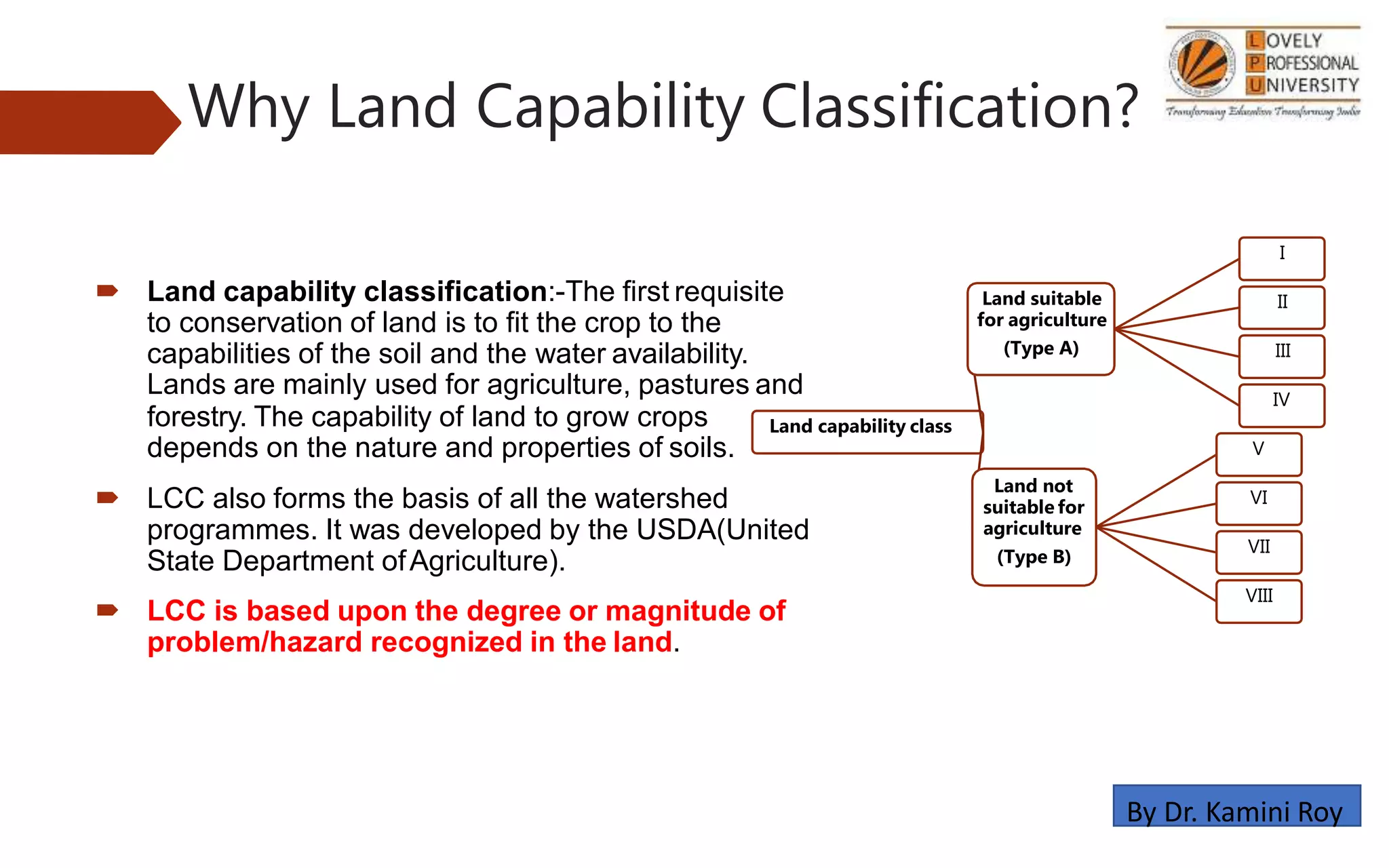
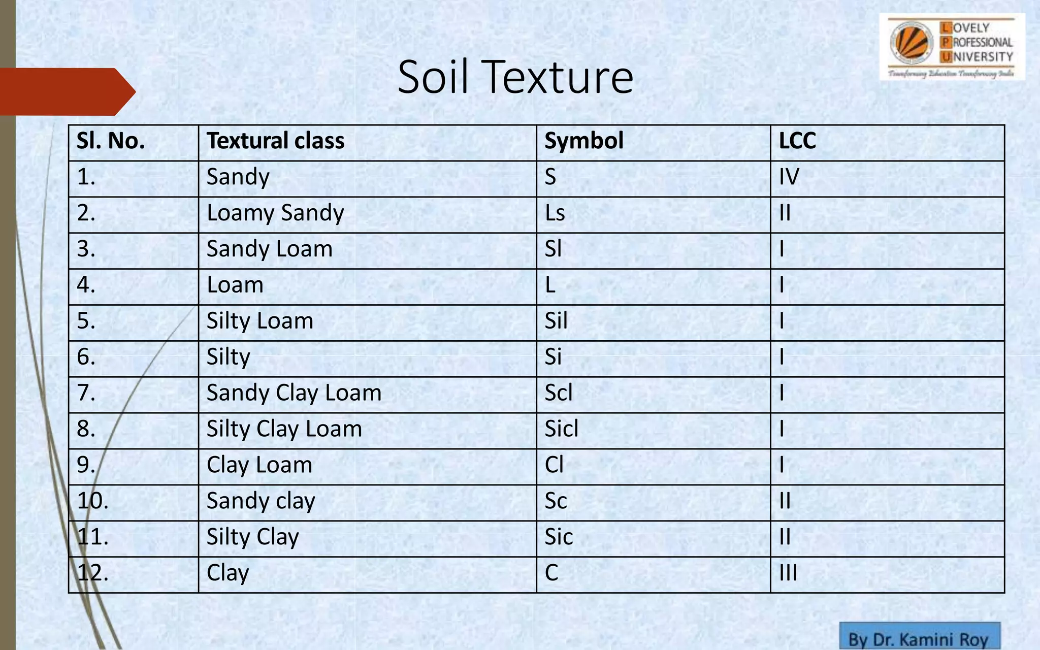
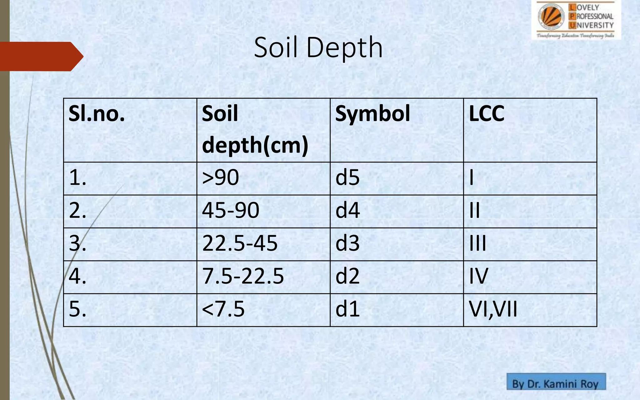
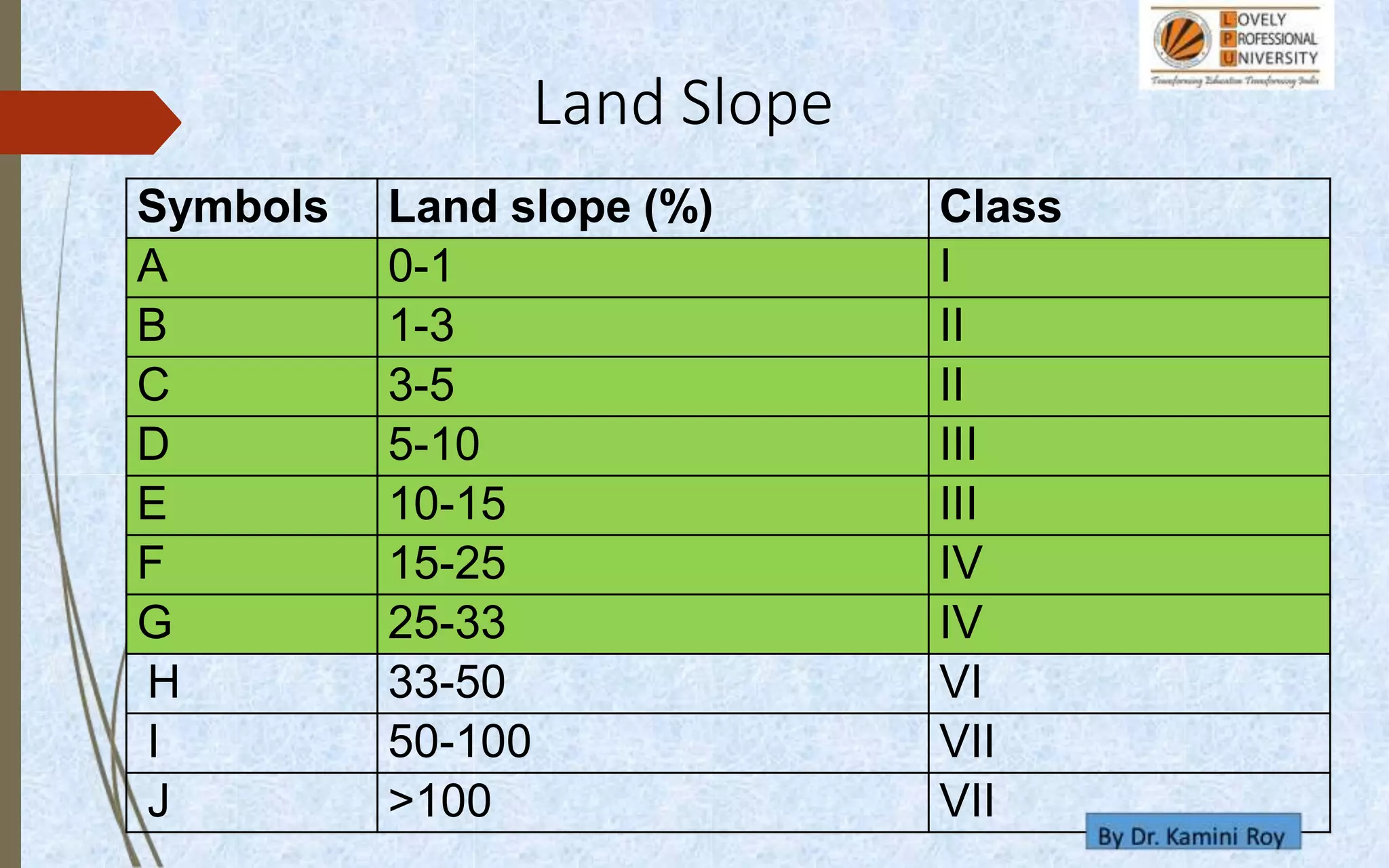
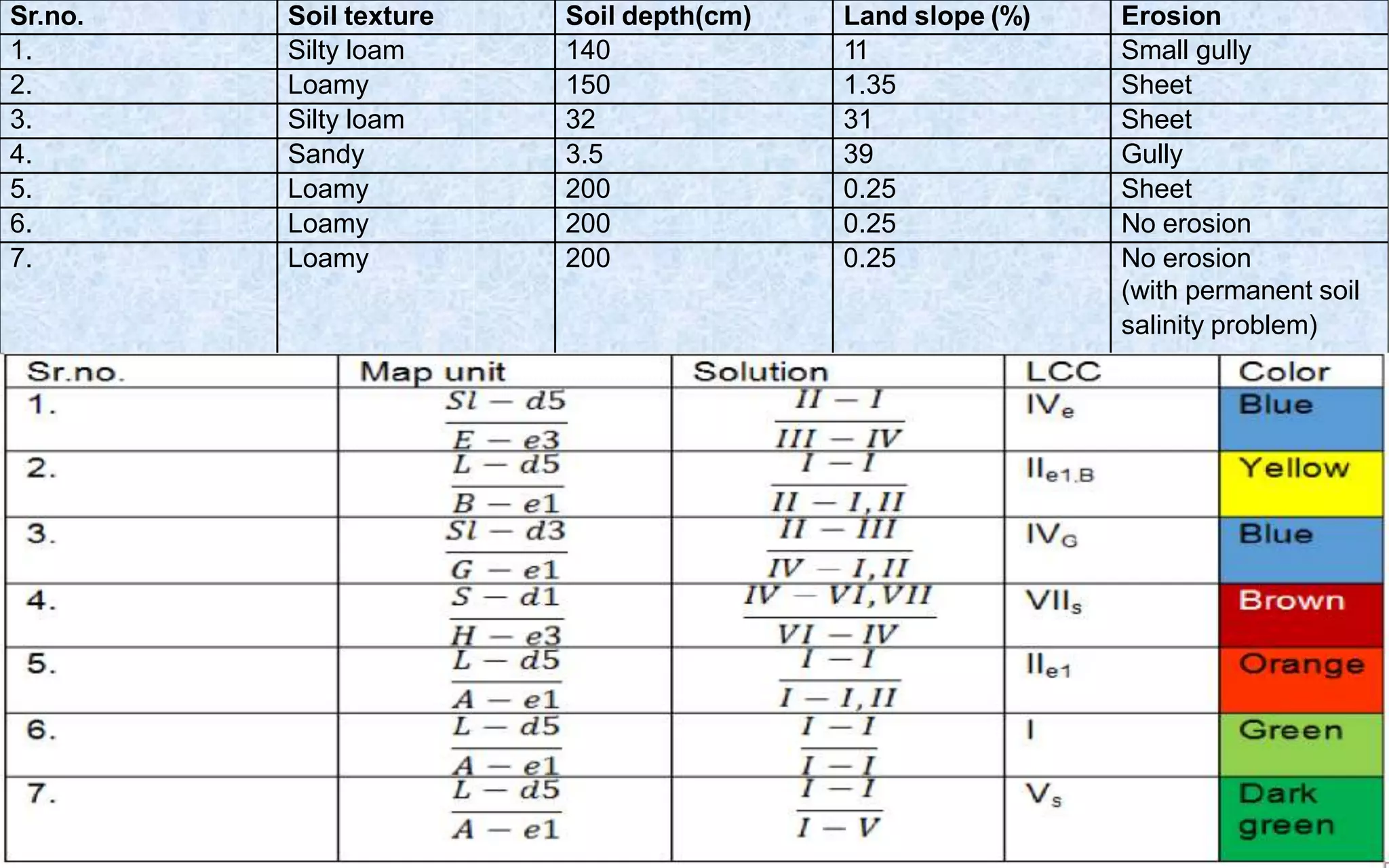
land capability
and
classification
• By- Dr. Kamini Roy
• Associate Professor, Agricultural Chemistry and
soil science,
• Lovely Professional University, Phagwara
• (First ICAR Accredited University)
By Dr. Kamini Roy
Introduction
Soil:-Soil is porous, powdery and unconsolidated
outer layer of the earth’s crust which is formed by
weathering of minerals and decomposition of
organic substances. Soil is dynamic, three
dimensional (having length, breadth and depth)
piece of landscape with a three phase (solid, liquid
and gaseous) system.
By Dr. Kamini Roy
• WHICH STATEMENT IS CORRECT
• A. Soil is porous
• B. Soil is powdery
• C, Soil is unconsolidated outer layer of the earth’s crust
• D. All of these
By Dr. Kamini Roy
Why Land Capability Classification?
 Land capability classification:-The first requisite
to conservation of land is to fit the crop to the
capabilities of the soil and the water availability.
Lands are mainly used for agriculture, pastures and
forestry. The capability of land to grow crops
depends on the nature and properties of soils.
 LCC also forms the basis of all the watershed
programmes. It was developed by the USDA(United
State Department ofAgriculture).
 LCC is based upon the degree or magnitude of
problem/hazard recognized in the land.
Land capability class
Land suitable
for agriculture
(Type A)
I
II
III
IV
Land not
suitable for
agriculture
(Type B)
V
VI
VII
VIII
By Dr. Kamini Roy
Factors influencing the land
capability classification
 Soil profile characteristics:-Soil texture, effective soil
depth, permeability and internal drainage, availability of
nutrients, soil salinity, soil alkalinity, and soil toxicity.
 External feature of the land: -Water logging, slope
and erosion are the factors that determine land
capability and limit the land for particular use only.
 Climate factors: -Rainfall, temperature and wind
velocity are important components that determine land
capability class.
Arable land
•  Class I:-
 Best suitable for all agricultural crops and free from hazards.
 Deep soil depth and high fertility.
 Not affected by any appreciable erosion, wetness , salinity etc.
• Which statement is wrong about Class I capability
classification of land:-
 A. Best suitable for all agricultural crops and free
from hazards.
 B. Deep soil depth and high fertility.
 C. Not affected by any appreciable erosion, wetness
, salinity etc.
 D. None of these
 CLASS II
 These lands have moderate soil depth, light or heavy texture, gentle
slope and moderate soil fertility etc.
 Suitable for permanent cultivation with some soil and water conservation
practices.
 Class III:-
 Various conservation measures like contour bunding, graded
bunding,etc are recommended.
 These lands are suitable for plants, provided that the plant
cover should be maintained.
 Class IV:-
 Suitable only for occasional or limited cultivation because of
unfavourable soil characteristics, slope, erosion, depth,
drainage, adverse climate etc.
 Engineering measures are recommended here.
NON-ARABLE LAND
 Class V:-
 These lands have the potential to become class I, but due to particular
problem/hazard, they can’t fulfil the characteristics of class I.
 Class VI:-
 These lands are suitable for horticultural crops like mango,
coffee, guava, cashew nut, etc.
 Grazing should be regulated to preserve the plant cover.
 Class VII:-
 These lands have severe limitations to use for grazing or forestry.
 Generally lands are droughty and swampy, having very steep slope, rough,
stony or very severely eroded, infested with gullies.
 Class VIII:-
 Lands are very rough, not suitable for wood land or grazing.
ASPECTS OF LCC
Sl. No. Textural class Symbol LCC
1. Sandy S IV
2. Loamy Sandy Ls II
3. Sandy Loam Sl I
4. Loam L I
5. Silty Loam Sil I
6. Silty Si I
7. Sandy Clay Loam Scl I
8. Silty Clay Loam Sicl I
9. Clay Loam Cl I
10. Sandy clay Sc II
11. Silty Clay Sic II
12. Clay C III
Soil Texture
• Soil texture Loamy Sandy comes under which class of LCC
• A. IV
• B. II
• C. I
• D. V
Sl.no. Soil
depth(cm)
Symbol LCC
1. >90 d5 I
2. 45-90 d4 II
3. 22.5-45 d3 III
4. 7.5-22.5 d2 IV
5. <7.5 d1 VI,VII
Soil Depth
Symbols Land slope (%) Class
A 0-1 I
B 1-3 II
C 3-5 II
D 5-10 III
E 10-15 III
F 15-25 IV
G 25-33 IV
H 33-50 VI
I 50-100 VII
J >100 VII
Land Slope
• 0-1% land slope considered in which class
A. Class 1
B. Class 2
C. Class 3
D. Class 4
Sl.no. Symbol Erosion
status
Class
1. e1 Sheet erosion I & II
2. e2 Rill erosion III
3. e3 Small erosion IV
4. e4 Big gully VI & VII
Erosion Status
• Erosion status of land having Rill erosion comes under which class
• A. I & II
• B. III
• C. IV
• D. VI & VII
Class Color Class Color
I Green V Dark green
II Yellow VI Orange
III Red VII Brown
IV Blue VIII Purple
Soil Color
The basis of sub class is to recognize the type
of problem/hazard.
The four types of hazards are
•E (erosion)
•W (water logging)
•S (soil related hazard, shallowness, stony)
•C (climate related hazards, too dry, too cold)
LCC sub class
Map Unit
Map unit for LCC is given by
Sr.no. Soil texture Soil depth(cm) Land slope (%) Erosion
1. Silty loam 140 11 Small gully
2. Loamy 150 1.35 Sheet
3. Silty loam 32 31 Sheet
4. Sandy 3.5 39 Gully
5. Loamy 200 0.25 Sheet
6. Loamy 200 0.25 No erosion
7. Loamy 200 0.25 No erosion
(with permanent soil
salinity problem)
Acknowledge and Thanks
Author is immensely thankful to all the
websites and books whom I contacted to make
these slides more informative and attractive
By Dr. Kamini Roy
WE SHALL OVERCOME
Stay healthy
By Dr. Kamini Roy

Unit 6 land capability classification sol220 8 april

  • 1.
    land capability and classification • By-Dr. Kamini Roy • Associate Professor, Agricultural Chemistry and soil science, • Lovely Professional University, Phagwara • (First ICAR Accredited University) By Dr. Kamini Roy
  • 2.
    Introduction Soil:-Soil is porous,powdery and unconsolidated outer layer of the earth’s crust which is formed by weathering of minerals and decomposition of organic substances. Soil is dynamic, three dimensional (having length, breadth and depth) piece of landscape with a three phase (solid, liquid and gaseous) system. By Dr. Kamini Roy
  • 3.
    • WHICH STATEMENTIS CORRECT • A. Soil is porous • B. Soil is powdery • C, Soil is unconsolidated outer layer of the earth’s crust • D. All of these By Dr. Kamini Roy
  • 4.
    Why Land CapabilityClassification?  Land capability classification:-The first requisite to conservation of land is to fit the crop to the capabilities of the soil and the water availability. Lands are mainly used for agriculture, pastures and forestry. The capability of land to grow crops depends on the nature and properties of soils.  LCC also forms the basis of all the watershed programmes. It was developed by the USDA(United State Department ofAgriculture).  LCC is based upon the degree or magnitude of problem/hazard recognized in the land. Land capability class Land suitable for agriculture (Type A) I II III IV Land not suitable for agriculture (Type B) V VI VII VIII By Dr. Kamini Roy
  • 5.
    Factors influencing theland capability classification  Soil profile characteristics:-Soil texture, effective soil depth, permeability and internal drainage, availability of nutrients, soil salinity, soil alkalinity, and soil toxicity.  External feature of the land: -Water logging, slope and erosion are the factors that determine land capability and limit the land for particular use only.  Climate factors: -Rainfall, temperature and wind velocity are important components that determine land capability class.
  • 6.
    Arable land • Class I:-  Best suitable for all agricultural crops and free from hazards.  Deep soil depth and high fertility.  Not affected by any appreciable erosion, wetness , salinity etc.
  • 7.
    • Which statementis wrong about Class I capability classification of land:-  A. Best suitable for all agricultural crops and free from hazards.  B. Deep soil depth and high fertility.  C. Not affected by any appreciable erosion, wetness , salinity etc.  D. None of these
  • 8.
     CLASS II These lands have moderate soil depth, light or heavy texture, gentle slope and moderate soil fertility etc.  Suitable for permanent cultivation with some soil and water conservation practices.
  • 9.
     Class III:- Various conservation measures like contour bunding, graded bunding,etc are recommended.  These lands are suitable for plants, provided that the plant cover should be maintained.
  • 10.
     Class IV:- Suitable only for occasional or limited cultivation because of unfavourable soil characteristics, slope, erosion, depth, drainage, adverse climate etc.  Engineering measures are recommended here.
  • 11.
    NON-ARABLE LAND  ClassV:-  These lands have the potential to become class I, but due to particular problem/hazard, they can’t fulfil the characteristics of class I.
  • 12.
     Class VI:- These lands are suitable for horticultural crops like mango, coffee, guava, cashew nut, etc.  Grazing should be regulated to preserve the plant cover.
  • 13.
     Class VII:- These lands have severe limitations to use for grazing or forestry.  Generally lands are droughty and swampy, having very steep slope, rough, stony or very severely eroded, infested with gullies.
  • 14.
     Class VIII:- Lands are very rough, not suitable for wood land or grazing.
  • 15.
  • 16.
    Sl. No. Texturalclass Symbol LCC 1. Sandy S IV 2. Loamy Sandy Ls II 3. Sandy Loam Sl I 4. Loam L I 5. Silty Loam Sil I 6. Silty Si I 7. Sandy Clay Loam Scl I 8. Silty Clay Loam Sicl I 9. Clay Loam Cl I 10. Sandy clay Sc II 11. Silty Clay Sic II 12. Clay C III Soil Texture
  • 17.
    • Soil textureLoamy Sandy comes under which class of LCC • A. IV • B. II • C. I • D. V
  • 19.
    Sl.no. Soil depth(cm) Symbol LCC 1.>90 d5 I 2. 45-90 d4 II 3. 22.5-45 d3 III 4. 7.5-22.5 d2 IV 5. <7.5 d1 VI,VII Soil Depth
  • 20.
    Symbols Land slope(%) Class A 0-1 I B 1-3 II C 3-5 II D 5-10 III E 10-15 III F 15-25 IV G 25-33 IV H 33-50 VI I 50-100 VII J >100 VII Land Slope
  • 21.
    • 0-1% landslope considered in which class A. Class 1 B. Class 2 C. Class 3 D. Class 4
  • 22.
    Sl.no. Symbol Erosion status Class 1.e1 Sheet erosion I & II 2. e2 Rill erosion III 3. e3 Small erosion IV 4. e4 Big gully VI & VII Erosion Status
  • 23.
    • Erosion statusof land having Rill erosion comes under which class • A. I & II • B. III • C. IV • D. VI & VII
  • 24.
    Class Color ClassColor I Green V Dark green II Yellow VI Orange III Red VII Brown IV Blue VIII Purple Soil Color
  • 25.
    The basis ofsub class is to recognize the type of problem/hazard. The four types of hazards are •E (erosion) •W (water logging) •S (soil related hazard, shallowness, stony) •C (climate related hazards, too dry, too cold) LCC sub class
  • 26.
    Map Unit Map unitfor LCC is given by
  • 27.
    Sr.no. Soil textureSoil depth(cm) Land slope (%) Erosion 1. Silty loam 140 11 Small gully 2. Loamy 150 1.35 Sheet 3. Silty loam 32 31 Sheet 4. Sandy 3.5 39 Gully 5. Loamy 200 0.25 Sheet 6. Loamy 200 0.25 No erosion 7. Loamy 200 0.25 No erosion (with permanent soil salinity problem)
  • 28.
    Acknowledge and Thanks Authoris immensely thankful to all the websites and books whom I contacted to make these slides more informative and attractive By Dr. Kamini Roy
  • 29.
    WE SHALL OVERCOME Stayhealthy By Dr. Kamini Roy