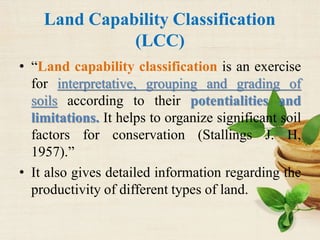
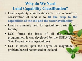
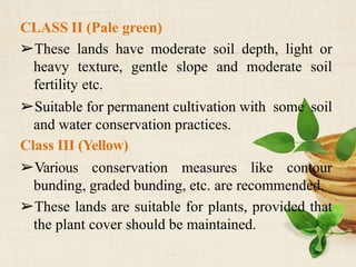
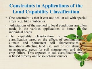
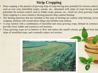
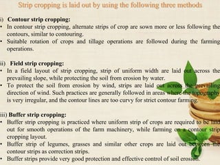
Land Capability Classification
and
Constraints in Application
Er. Piyush R Kowe
Asst. Prof. Agricultural Engineering
SSWP COA Kesalwada, Lakhni.
INDEX
• Introduction
• Why do we use LCC
• When to use LCC
• Criteria of LCC
• Land capability classification
• Constraints in Applications of the Land
Capability Classification
• Conclusion
Introduction
 Soil-Soil is porous, powdery and unconsolidated outer layer of the earth’s crust which is
formed by weathering of minerals and decomposition of organic substances. Soil is
dynamic, three dimensional (having length, breadth and depth) piece of landscape with a
three phase (solid, liquid and gaseous) system.
 Land-Land is two dimensional body. Land is the solid part of the earth's surface. Our
land is home to many unique plants and animals. The term 'land' includes all physical
elements in the wealth of a nation bestowed by nature; such as climate, environment,
fields, forests, minerals, mountains, lakes, streams, seas, and animals. To use our land
wisely we have to understand soil.
 The solid surface of Earth that is not permanently covered by water.
 Landscape-Landscape is three dimensional structure.
 A landscape is the visible features of an area of land, its landforms, and how they
integrate with natural or man-made features. A landscape includes the physical elements
of geophysically defined landforms such as (ice-capped) mountains, hills, water
bodies such as rivers, lakes, ponds and the sea, living elements of land cover including
indigenous vegetation, human elements including different forms of land use, buildings,
and structures, and transitory elements such as lighting and weather conditions.
Combining both their physical origins and the cultural overlay of human presence, often
created over millennia, landscapes reflect a living synthesis of people and place that is
vital to local and national identity.
Capability Vs Suitability
Capability:- Capability is viewed by some as
the inherent capacity of land to perform at a
given level for a general use. and
Suitability:- Suitability as a statement of the
adaptability of a given area for a specific kind
of land use; others see capability as a
classification of land primarily in relation to
degradation hazards (FAO, 1976).
Land Capability Classification
(LCC)
• “Land capability classification is an exercise
for interpretative, grouping and grading of
soils according to their potentialities and
limitations. It helps to organize significant soil
factors for conservation (Stallings J. H,
1957).”
• It also gives detailed information regarding the
productivity of different types of land.
Why do We Need
Land Capability Classification?
• Land capability classification:-The first requisite to
conservation of land is to fit the crop to the
capabilities of the soil and the water availability.
• Lands are mainly used for agriculture, pastures and
forestry.
• LCC forms the basis of all the watershed
programmes. It was developed by the USDA(United
State Department ofAgriculture).
• LCC is based upon the degree or magnitude of
problem/hazard recognized in the land.
According to Kalmalkar, R. J. (1950)- Improper
selection of lands for agriculture uses and lack
of management measures in accordance with
its capabilities greatly deteriorate the soils.
When to Use Land Capability
Classification?
Identification of different groups of land
suitable to different types of production and,
Mapping of broad types of agricultural land
suitability.
Criteria
of
Land Capability Classification
Criteria/ Factors Influencing Land
Capability Classification
Soil profile
characteristics
External feature of
the land
Climate factors
 Soil texture  Water logging  Rainfall
 Effective soil  Slope and erosion  Temperature and
depth are the factors that  Wind velocity are
 Permeability and determine land important
internal drainage capability and limit components that
 Availability of the land for determine land
nutrients particular use only. capability class.
 Soil salinity
 Soil alkalinity, and
 Soil toxicity.
LCC Classification
a) Capability class,
b) Capability subclass and
c) Capability unit
Capability Class
Broadly, It is classified into two groups:
1)Arable land classes (Cultivable)
2)Non-arable land (Non Cultivable)
• In arable land frequent disturbance of soil
occur e.g. Crop field.
• Forest is the example of non- arable land.
Arable Land
Class I (Dark green)
➢Best suitable for all agricultural crops and
free from hazards.
➢ Deep soil depth and high fertility.
➢Not affected by any appreciable erosion,
wetness , salinity etc.
CLASS II (Pale green)
➢These lands have moderate soil depth, light or
heavy texture, gentle slope and moderate soil
fertility etc.
➢Suitable for permanent cultivation with some soil
and water conservation practices.
Class III (Yellow)
➢Various conservation measures like contour
bunding, graded bunding, etc. are recommended.
➢These lands are suitable for plants, provided that
the plant cover should be maintained.
Class IV (Pink)
➢ Suitable only for occasional or limited
cultivation because of unfavourable soil
characteristics, slope, erosion, depth, drainage,
adverse climate etc.
➢ Engineering measures are recommended here.
NON-ARABLE LAND
Class V (Blue)
➢These lands have the potential to become
class I, but due to particular problem/hazard,
they can’t fulfill the characteristics of class I.
Class VI (Orange)
➢These lands are suitable for horticultural crops
like mango, coffee, guava, cashew nut, etc.
➢Grazing should be regulated to preserve the
plant cover.
Class VII (Red)
➢These lands have severe limitations to use for
grazing or forestry.
➢Generally lands are droughty and swampy,
having very steep slope, rough, stony or very
severely eroded, infested with gullies.
Class VIII (Purple/ Violet)
➢Lands are very rough, not suitable for wood
land or grazing.
LCC Sub-class
The basis of sub class is to recognize the type of
problem/hazard.
The four types of hazards are:-
1. E (erosion)
2. W (water logging)
3. S (soil related hazard)
4. C (climate related hazard)
Capability Unit
 The capability unit is a subdivision of the capability
subclasses depending on the management practices.
For example, class IIIs (Soils have severe limitations
that reduce the choice of plants, require special
conservation practices, or both;
 Soil limitations within the rooting zone) could be due
to excess gravel in the root zone or excess salts, i.e.
the codes IIIs1 and IIIs2 could be assigned.
 The capability units are assigned for the individual
applications, but they generally correspond to phases
or soil groups in the national soil survey.
Constraints in Applications of the
Land Capability Classification
• One constraint is that it can not deal at all with special
crops, e.g. like cranberries.
• Adaptations of the method to local conditions are often
made in the various applications to better fit the
individual needs.
• The capability classification is an interpretive
classification based on the effects of combinations of
climate and permanent soil characteristics on:
limitations affecting land use, risk of soil damage if
mismanaged, needs for soil management and risk of
crop failure. This opposed to soil classification, which
is based directly on the soil characteristics.
• The criteria on the presence of water on the surface or
excess water in the soil, lack of water for adequate
crop production, presence of stones, presence of
soluble salts or exchangeable sodium, or both, or
hazard of overflow are not considered as permanent
limitations to use in the classification where the
removal of these limitations is feasible.
• Within a class there might be different soils but with
the same degree of limitations in soil use for
agricultural purposes or hazards to the soil, when it is
used. If the land unit consists of more than one
capability class the land unit is given the lowest class.
• There is no crop productivity rating, i.e. class IV (see
below) can be more productive than class I, but also
more fragile.
Continued…
• Profitability is not determined.
• A single moderately high level of management
is assumed.
• Factors such as distance to market, conditions
of roads and location of fields are not included.
Conclusion
• LCC makes easier to classify different types of
land into specific class based on their
potentialities.
• Suitable land utilization
Agronomical Measures for Erosion Control.
Contour Cropping:
• Contour Cropping is a conservation farming method that is used on slopes to control soil
losses due to water erosion.
• Contour cropping involves planting crops across the slope instead of up and down the slope.
• Use of contour cropping protects the valuable top soil by reducing the velocity of runoff
water and inducing more infiltration.
• On long and smooth slope, contour cropping is more effective as the velocity of flow is high
under such situation and contour cropping shortens the slope length to reduce the flow velocity.
• Contour cropping is most effective on slopes between 2 and 10 percent.
Strip Cropping
• Strip cropping is the practice of growing strip of crops having poor potential for erosion control,
such as root crop (intertilled crops), cereals, etc., alternated with strips of crops having good
potentials for erosion control, such as fodder crops, grasses, etc., which are close growing crops
Strip cropping is a more intensive farming practice than contour farming.
• The farming practices that are included in this type of farming are contour strip farming, cover
cropping, farming with conservation tillage and suitable crop rotation.
• A crop rotation with a combination of intertilled and close growing crops, farmed on contours,
provides food, fodder and conserves soil moisture.
• Close growing crops act as barriers to flow and reduce the runoff velocity generated from the
strips of intertilled crops, and eventually reduce soil erosion.
Strip cropping is laid out by using the following three methods
i) Contour strip cropping:
• In contour strip cropping, alternate strips of crop are sown more or less following the
contours, similar to contouring.
• Suitable rotation of crops and tillage operations are followed during the farming
operations.
ii) Field strip cropping:
• In a field layout of strip cropping, strip of uniform width are laid out across the
prevailing slope, while protecting the soil from erosion by water.
• To protect the soil from erosion by wind, strips are laid out across the prevailing
direction of wind. Such practices are generally followed in areas where the topography
is very irregular, and the contour lines are too curvy for strict contour farming.
iii) Buffer strip cropping:
• Buffer strip cropping is practiced where uniform strip of crops are required to be laid
out for smooth operations of the farm machinery, while farming on a contour strip
cropping layout.
• Buffer strip of legumes, grasses and similar other crops are laid out between the
contour strips as correction strips.
• Buffer strips provide very good protection and effective control of soil erosion.
Mulching
• Mulches are used to minimize rain splash, reduce evaporation, control
weeds, reduce temperature of soil in hot climates, and moderate the
temperature to a level conducive to microbial activity.
• Mulches help in breaking the energy of raindrops, prevent splash and
dissipation of soil structure, obstruct the flow of runoff to reduce their
velocity and prevent sheet and rill erosion.
• They also help in improving the infiltration capacity by maintaining a
conductive soil structure at the top surface of land.
To protect the land from erosion different types of materials are used Ex.
Cut Grasses, Straw materials, Wood chips, Saw dust, Papers, Stones,
Glass wools, Metal foils and Plastics.
Lecture 4. LCC.pptx
Lecture 4. LCC.pptx
Lecture 4. LCC.pptx
Lecture 4. LCC.pptx

Lecture 4. LCC.pptx

  • 1.
    Land Capability Classification and Constraintsin Application Er. Piyush R Kowe Asst. Prof. Agricultural Engineering SSWP COA Kesalwada, Lakhni.
  • 2.
    INDEX • Introduction • Whydo we use LCC • When to use LCC • Criteria of LCC • Land capability classification • Constraints in Applications of the Land Capability Classification • Conclusion
  • 3.
    Introduction  Soil-Soil isporous, powdery and unconsolidated outer layer of the earth’s crust which is formed by weathering of minerals and decomposition of organic substances. Soil is dynamic, three dimensional (having length, breadth and depth) piece of landscape with a three phase (solid, liquid and gaseous) system.  Land-Land is two dimensional body. Land is the solid part of the earth's surface. Our land is home to many unique plants and animals. The term 'land' includes all physical elements in the wealth of a nation bestowed by nature; such as climate, environment, fields, forests, minerals, mountains, lakes, streams, seas, and animals. To use our land wisely we have to understand soil.  The solid surface of Earth that is not permanently covered by water.  Landscape-Landscape is three dimensional structure.  A landscape is the visible features of an area of land, its landforms, and how they integrate with natural or man-made features. A landscape includes the physical elements of geophysically defined landforms such as (ice-capped) mountains, hills, water bodies such as rivers, lakes, ponds and the sea, living elements of land cover including indigenous vegetation, human elements including different forms of land use, buildings, and structures, and transitory elements such as lighting and weather conditions. Combining both their physical origins and the cultural overlay of human presence, often created over millennia, landscapes reflect a living synthesis of people and place that is vital to local and national identity.
  • 4.
    Capability Vs Suitability Capability:-Capability is viewed by some as the inherent capacity of land to perform at a given level for a general use. and Suitability:- Suitability as a statement of the adaptability of a given area for a specific kind of land use; others see capability as a classification of land primarily in relation to degradation hazards (FAO, 1976).
  • 5.
    Land Capability Classification (LCC) •“Land capability classification is an exercise for interpretative, grouping and grading of soils according to their potentialities and limitations. It helps to organize significant soil factors for conservation (Stallings J. H, 1957).” • It also gives detailed information regarding the productivity of different types of land.
  • 6.
    Why do WeNeed Land Capability Classification? • Land capability classification:-The first requisite to conservation of land is to fit the crop to the capabilities of the soil and the water availability. • Lands are mainly used for agriculture, pastures and forestry. • LCC forms the basis of all the watershed programmes. It was developed by the USDA(United State Department ofAgriculture). • LCC is based upon the degree or magnitude of problem/hazard recognized in the land.
  • 7.
    According to Kalmalkar,R. J. (1950)- Improper selection of lands for agriculture uses and lack of management measures in accordance with its capabilities greatly deteriorate the soils.
  • 8.
    When to UseLand Capability Classification? Identification of different groups of land suitable to different types of production and, Mapping of broad types of agricultural land suitability.
  • 9.
  • 10.
    Criteria/ Factors InfluencingLand Capability Classification Soil profile characteristics External feature of the land Climate factors  Soil texture  Water logging  Rainfall  Effective soil  Slope and erosion  Temperature and depth are the factors that  Wind velocity are  Permeability and determine land important internal drainage capability and limit components that  Availability of the land for determine land nutrients particular use only. capability class.  Soil salinity  Soil alkalinity, and  Soil toxicity.
  • 11.
    LCC Classification a) Capabilityclass, b) Capability subclass and c) Capability unit
  • 12.
    Capability Class Broadly, Itis classified into two groups: 1)Arable land classes (Cultivable) 2)Non-arable land (Non Cultivable) • In arable land frequent disturbance of soil occur e.g. Crop field. • Forest is the example of non- arable land.
  • 13.
    Arable Land Class I(Dark green) ➢Best suitable for all agricultural crops and free from hazards. ➢ Deep soil depth and high fertility. ➢Not affected by any appreciable erosion, wetness , salinity etc.
  • 14.
    CLASS II (Palegreen) ➢These lands have moderate soil depth, light or heavy texture, gentle slope and moderate soil fertility etc. ➢Suitable for permanent cultivation with some soil and water conservation practices. Class III (Yellow) ➢Various conservation measures like contour bunding, graded bunding, etc. are recommended. ➢These lands are suitable for plants, provided that the plant cover should be maintained.
  • 15.
    Class IV (Pink) ➢Suitable only for occasional or limited cultivation because of unfavourable soil characteristics, slope, erosion, depth, drainage, adverse climate etc. ➢ Engineering measures are recommended here.
  • 16.
    NON-ARABLE LAND Class V(Blue) ➢These lands have the potential to become class I, but due to particular problem/hazard, they can’t fulfill the characteristics of class I. Class VI (Orange) ➢These lands are suitable for horticultural crops like mango, coffee, guava, cashew nut, etc. ➢Grazing should be regulated to preserve the plant cover.
  • 17.
    Class VII (Red) ➢Theselands have severe limitations to use for grazing or forestry. ➢Generally lands are droughty and swampy, having very steep slope, rough, stony or very severely eroded, infested with gullies. Class VIII (Purple/ Violet) ➢Lands are very rough, not suitable for wood land or grazing.
  • 18.
    LCC Sub-class The basisof sub class is to recognize the type of problem/hazard. The four types of hazards are:- 1. E (erosion) 2. W (water logging) 3. S (soil related hazard) 4. C (climate related hazard)
  • 19.
    Capability Unit  Thecapability unit is a subdivision of the capability subclasses depending on the management practices. For example, class IIIs (Soils have severe limitations that reduce the choice of plants, require special conservation practices, or both;  Soil limitations within the rooting zone) could be due to excess gravel in the root zone or excess salts, i.e. the codes IIIs1 and IIIs2 could be assigned.  The capability units are assigned for the individual applications, but they generally correspond to phases or soil groups in the national soil survey.
  • 20.
    Constraints in Applicationsof the Land Capability Classification • One constraint is that it can not deal at all with special crops, e.g. like cranberries. • Adaptations of the method to local conditions are often made in the various applications to better fit the individual needs. • The capability classification is an interpretive classification based on the effects of combinations of climate and permanent soil characteristics on: limitations affecting land use, risk of soil damage if mismanaged, needs for soil management and risk of crop failure. This opposed to soil classification, which is based directly on the soil characteristics.
  • 21.
    • The criteriaon the presence of water on the surface or excess water in the soil, lack of water for adequate crop production, presence of stones, presence of soluble salts or exchangeable sodium, or both, or hazard of overflow are not considered as permanent limitations to use in the classification where the removal of these limitations is feasible. • Within a class there might be different soils but with the same degree of limitations in soil use for agricultural purposes or hazards to the soil, when it is used. If the land unit consists of more than one capability class the land unit is given the lowest class. • There is no crop productivity rating, i.e. class IV (see below) can be more productive than class I, but also more fragile.
  • 22.
    Continued… • Profitability isnot determined. • A single moderately high level of management is assumed. • Factors such as distance to market, conditions of roads and location of fields are not included.
  • 23.
    Conclusion • LCC makeseasier to classify different types of land into specific class based on their potentialities. • Suitable land utilization
  • 24.
    Agronomical Measures forErosion Control. Contour Cropping: • Contour Cropping is a conservation farming method that is used on slopes to control soil losses due to water erosion. • Contour cropping involves planting crops across the slope instead of up and down the slope. • Use of contour cropping protects the valuable top soil by reducing the velocity of runoff water and inducing more infiltration. • On long and smooth slope, contour cropping is more effective as the velocity of flow is high under such situation and contour cropping shortens the slope length to reduce the flow velocity. • Contour cropping is most effective on slopes between 2 and 10 percent.
  • 26.
    Strip Cropping • Stripcropping is the practice of growing strip of crops having poor potential for erosion control, such as root crop (intertilled crops), cereals, etc., alternated with strips of crops having good potentials for erosion control, such as fodder crops, grasses, etc., which are close growing crops Strip cropping is a more intensive farming practice than contour farming. • The farming practices that are included in this type of farming are contour strip farming, cover cropping, farming with conservation tillage and suitable crop rotation. • A crop rotation with a combination of intertilled and close growing crops, farmed on contours, provides food, fodder and conserves soil moisture. • Close growing crops act as barriers to flow and reduce the runoff velocity generated from the strips of intertilled crops, and eventually reduce soil erosion.
  • 28.
    Strip cropping islaid out by using the following three methods i) Contour strip cropping: • In contour strip cropping, alternate strips of crop are sown more or less following the contours, similar to contouring. • Suitable rotation of crops and tillage operations are followed during the farming operations. ii) Field strip cropping: • In a field layout of strip cropping, strip of uniform width are laid out across the prevailing slope, while protecting the soil from erosion by water. • To protect the soil from erosion by wind, strips are laid out across the prevailing direction of wind. Such practices are generally followed in areas where the topography is very irregular, and the contour lines are too curvy for strict contour farming. iii) Buffer strip cropping: • Buffer strip cropping is practiced where uniform strip of crops are required to be laid out for smooth operations of the farm machinery, while farming on a contour strip cropping layout. • Buffer strip of legumes, grasses and similar other crops are laid out between the contour strips as correction strips. • Buffer strips provide very good protection and effective control of soil erosion.
  • 29.
    Mulching • Mulches areused to minimize rain splash, reduce evaporation, control weeds, reduce temperature of soil in hot climates, and moderate the temperature to a level conducive to microbial activity. • Mulches help in breaking the energy of raindrops, prevent splash and dissipation of soil structure, obstruct the flow of runoff to reduce their velocity and prevent sheet and rill erosion. • They also help in improving the infiltration capacity by maintaining a conductive soil structure at the top surface of land. To protect the land from erosion different types of materials are used Ex. Cut Grasses, Straw materials, Wood chips, Saw dust, Papers, Stones, Glass wools, Metal foils and Plastics.