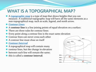
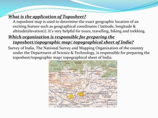
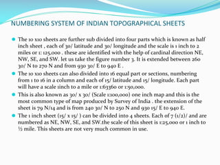
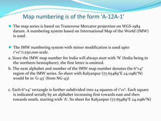
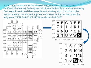
TOPOSHEET
SEM-I/CC2
CONTENT
Survey of India topographical maps:
Reference scheme of old and open series.
Information on the margin of maps.
SOMA MUKHOPADHYAY
RKSMVV
WHAT IS MAPS?
⚫ Map is a representation or a drawing of the earth’s surface or a part of it on a
flat surface according to a scale.
⚫ Types of Maps
⚫ Physical or Relief Maps
⚫ Political Maps
⚫ Thematic Maps
⚫ Sketch
⚫ Plan
⚫ Components of Maps
⚫ Distance
⚫ Direction
⚫ Symbols
WHAT IS A TOPOGRAPHICAL MAP?
⚫ A topographic map is a type of map that shows heights that you can
measure. A traditional topographic map will have all the same elements as a
non-topographical map, such as scale, legend, and north arrow.
⚫ Contour Lines
⚫ A contour line is a line joining points of equal elevation on a surface.
⚫ There are three rules for contour lines:
⚫ Every point along a contour line is the exact same elevation
⚫ Contour lines can never cross each other
⚫ A contour line must close on itself
⚫ Contour Interval
⚫ A topographical map will contain many
⚫ contour lines, but the change in elevation
⚫ between each line will remain the same;
⚫ this is called a contour interval.
What is the application of Toposheet?
A toposheet map is used to determine the exact geographic location of an
exciting feature such as geographical coordinates ( latitude, longitude &
altitude(elevation)). It’s very helpful for tours, travelling, hiking and trekking.
Which organization is responsible for preparing the
toposheet/topographic map/ topographical sheet of India?
Survey of India, The National Survey and Mapping Organization of the country
under the Department of Science & Technology, is responsible for preparing the
toposheet/topographic map/ topographical sheet of India.
SURVEY OF INDIA
⚫ The Survey of India (SOI), which is 232 years old, is responsible for all
topographical and developmental surveys.
⚫ Digital Cartographic Data Base on 1:2,50,000 scale has been initiated.
Geographical Information system (GIS) has also been adopted. Thus the SOI
has kept abreast of the things in all aspects of Cartography and surveying.
⚫ Map coverage
India, with an area of 32,87,263 Km2, is covered by both topographical maps
and geographical maps. The topographical maps are on sufficiently large scale
of 1:25,000, 1:50,000 which are ideally suited for the professional work of
geologists, geographers, foresters, engineers, planners, tourists, trekkers,
mountaineers and others.
⚫ India is covered by nearly 385 toposheets on 1:2,50,000 scale and these are also
called as Degree Sheets. Each Degree sheet has 16 top0osheets of 1:50,000 scale
and at present the whole of the country is covered by 1:50,000 rigorous metric
surveys in more than 5000 toposheets.
OLD SERIES MAP
⚫ A map series is a group of topographic or thematic charts or maps usually having
the same scale and cartographic specifications, and with each sheet appropriately
identified by its publisher as belonging to the same series.
⚫ In everyday use, individual maps and atlases are sometimes described as being part
of a "map series".
Features
⚫ Map series are divided into particular systems of single sheets named and
numbered according to common principles. Thus, the characteristics of a particular
sheet in a map series apply equally to all the other sheets of the map series. So, for
example, all sheets normally have the same cartographic projections, geodetic
datums, scale, and a uniform content and cartographic design.
⚫ Sheet network designs-Mercator Projection
⚫ Organization-they bear all of the common map series titles, have the same author
and copyright notices, use the same map legend and, with the exception of any
possible edge sheets, are usually printed on paper of a uniform size.
⚫ Nature of the sheet divisions-The sheets are divided from each other either
square to the map grid, or along the meridians and parallels. In the first case, the
sheets will all be the same size. In the second case, the sheet size will decrease
towards the north or the south.
Numbering and naming systems
⚫Consecutively in order of appearance
⚫Continuous row by row, or column by column
⚫According to zones and columns
⚫By longitude and latitude
⚫According to subdivisions
of the International Map of the World
40 5 8
32 15
36 37 38
42 43 44
1211 1212 1213
1231 1232 1233
3648 3748 3848
3647 3747 3847
M-35-V M-35-VI M-36-I
M-35-XI M-35-XII M-36-VII
Open Series Maps
⚫ Survey of India (SOI) brings out two series of maps through the National Map
Policy, 2005.
⚫ Defence Series Maps (DSMs) - These topographical maps (on Everest/WGS-84
Datum and Polyconic/UTM Projection) are on various scales (with heights,
contours and full content without dilution of accuracy). These maps mainly
cater for defence and national security requirements. This series of maps (in
analogue or digital forms) for the entire country are classified by the Ministry
of Defence.
⚫ Open Series Maps (OSMs) - OSMs are brought out exclusively by SOI,
primarily for supporting development activities in the country. OSMs bear
different map sheet numbers and are in UTM Projection on WGS-84 datum.
Each of these OSMs (in both hard copy and digital form) become
‘Unrestricted’.
NUMBERING SYSTEM OF INDIAN TOPOGRAPHICAL SHEETS
⚫ Geological Survey of India , a department under Ministry of science and
Technology of Government of India located at Dehradun is prepare topographic
maps. The maps are in 3 different scales: 1: 25,000, 1:50,000, and 1: 250,000. All
maps represents some particular area and these are prepared from the top of the
map towards north so that study of the map is easy. All the maps are numbered
and this system of sheet numbering by survey of india is called “India and Adjacent
Countries series.” Each series is numbered to help to locate the areas or places.
⚫ For example , sheet number 79 is consider for further discussion. Its extension is
from 240 N to 280 N and from 900 E to 940 E .
⚫ The million sheet has been sub divided into 16 sections(4 row and 4 column), each
of 10 latitude x 10 longitude and each part is numbered with block capital letter of
English alphabet A to P. the sections start from North West directions, run column
wise and end in South East direction.
⚫ As the extension of each section is 10 latitude and 10 longitude the scale of this
sheet is 1 inch to 4 miles or 1: 250,000. The numbering of one o the sheet is 79 N
and its extension is from 260 N to 270 N and from 930 E to 940 E.
NUMBERING SYSTEM OF INDIAN TOPOGRAPHICAL SHEETS
⚫ The 10 x10 sheets are further sub divided into four parts which is known as half
inch sheet , each of 30/ latitude and 30/ longitude and the scale is 1 inch to 2
miles or 1: 125,000 . these are identified with the help of cardinal direction NE,
NW, SE, and SW. let us take the figure number 3. It is extended between 260
30/ N to 270 N and from 930 30/ E to 940 E .
⚫ The 10 x10 sheets can also divided into 16 equal part or sections, numbering
from 1 to 16 in a column and each of 15/ latitude and 15/ longitude. Each part
will have a scale 1inch to a mile or 1:63360 or 1:50,000.
⚫ This is also known as 30/ x 30/ (Scale 1:100,000) one inch map and this is the
most common type of map produced by Survey of India . the extension of the
sheet is 79 N/14 and is from 240 30/ N to 250 N and 930 15/ E to 940 E.
⚫ The 1 inch sheet (15/ x 15/ ) can be divided into 4 sheets. Each of 7 (1/2)/ and are
numbered as NE, NW, SE, and SW.the scale of this sheet is 1:25,000 or 1 inch to
½ mile. This sheets are not very much common in use.
Map numbering is of the form 'A-12A-1'
⚫ The map series is based on Transverse Mercator projection on WGS-1984
datum. A numbering system based on International Map of the World (IMW)
is used.
⚫ The IMW numbering system with minor modification is used upto
1°×1°/1:250,000 scale.
a. Since the IMW map number for India will always start with 'N' (India being in
the northern hemisphere), the first letter is omitted.
b. The next alphabet and number of the IMW map number denotes the 6°×4°
region of the IMW series. So sheet with Kalyanpur (77.65489°E 24.11981°N)
would be in 'G-43' (from NG-43)
c. Each 6°×4° rectangle is further subdivided into 24 squares of 1°×1°. Each square
is indicated serially by an alphabet increasing first towards east and then
towards south, starting with 'A'. So sheet for Kalyanpur (77.65489°E 24.11981°N)
2. Each 1°×1° square is further divided into 16 squares of 15'×15' (15
minutes×15 minutes). Each square is indicated serially by a number increasing
first towards south and then towards east, starting with '1' (similar to the
system adopted in India and Adjacent Countries). So for the map sheet for
Kalyanpur (77°39.293'E 24°7.187'N) would be 'G-43X-12'
Uses of Topographic Map
⚫ It can have several uses which are mentioned below:
⚫ These maps can be used for any kind of geographic planning or
architecture purposes.
⚫ It can be used in matters of Earth Science and Geography.
⚫ It can be used in mining and other such purposes like the
construction of ponds etc.
⚫ It can be used for recreational purposes as well. For example,
hiking or mountaineering, etc.
⚫ It can be used to get any detailed description of any area or any
geographical feature. For example, drainage, landforms, forests,
communication or transportation routes, etc.
⚫ It can be used to get detailed information on any man-made
features as well.
⚫ It can be used in civil engineering as well.
⚫ It can be used by the government for planning or administrative
purposes or can be used by the private Industrial players as well.
References:-
⚫http://www.dspmuranchi.ac.in/pdf/Blog/Numbering
%20System%20of%20Indian%20SOI%20Topographic
al%20Sheets.pdf
⚫https://drr.ikcest.org/tutorial/k1045

Toposheet. toposheet Topo sheet topsheet

  • 1.
    TOPOSHEET SEM-I/CC2 CONTENT Survey of Indiatopographical maps: Reference scheme of old and open series. Information on the margin of maps. SOMA MUKHOPADHYAY RKSMVV
  • 2.
    WHAT IS MAPS? ⚫Map is a representation or a drawing of the earth’s surface or a part of it on a flat surface according to a scale. ⚫ Types of Maps ⚫ Physical or Relief Maps ⚫ Political Maps ⚫ Thematic Maps ⚫ Sketch ⚫ Plan ⚫ Components of Maps ⚫ Distance ⚫ Direction ⚫ Symbols
  • 3.
    WHAT IS ATOPOGRAPHICAL MAP? ⚫ A topographic map is a type of map that shows heights that you can measure. A traditional topographic map will have all the same elements as a non-topographical map, such as scale, legend, and north arrow. ⚫ Contour Lines ⚫ A contour line is a line joining points of equal elevation on a surface. ⚫ There are three rules for contour lines: ⚫ Every point along a contour line is the exact same elevation ⚫ Contour lines can never cross each other ⚫ A contour line must close on itself ⚫ Contour Interval ⚫ A topographical map will contain many ⚫ contour lines, but the change in elevation ⚫ between each line will remain the same; ⚫ this is called a contour interval.
  • 4.
    What is theapplication of Toposheet? A toposheet map is used to determine the exact geographic location of an exciting feature such as geographical coordinates ( latitude, longitude & altitude(elevation)). It’s very helpful for tours, travelling, hiking and trekking. Which organization is responsible for preparing the toposheet/topographic map/ topographical sheet of India? Survey of India, The National Survey and Mapping Organization of the country under the Department of Science & Technology, is responsible for preparing the toposheet/topographic map/ topographical sheet of India.
  • 5.
    SURVEY OF INDIA ⚫The Survey of India (SOI), which is 232 years old, is responsible for all topographical and developmental surveys. ⚫ Digital Cartographic Data Base on 1:2,50,000 scale has been initiated. Geographical Information system (GIS) has also been adopted. Thus the SOI has kept abreast of the things in all aspects of Cartography and surveying. ⚫ Map coverage India, with an area of 32,87,263 Km2, is covered by both topographical maps and geographical maps. The topographical maps are on sufficiently large scale of 1:25,000, 1:50,000 which are ideally suited for the professional work of geologists, geographers, foresters, engineers, planners, tourists, trekkers, mountaineers and others. ⚫ India is covered by nearly 385 toposheets on 1:2,50,000 scale and these are also called as Degree Sheets. Each Degree sheet has 16 top0osheets of 1:50,000 scale and at present the whole of the country is covered by 1:50,000 rigorous metric surveys in more than 5000 toposheets.
  • 6.
  • 7.
    ⚫ A mapseries is a group of topographic or thematic charts or maps usually having the same scale and cartographic specifications, and with each sheet appropriately identified by its publisher as belonging to the same series. ⚫ In everyday use, individual maps and atlases are sometimes described as being part of a "map series". Features ⚫ Map series are divided into particular systems of single sheets named and numbered according to common principles. Thus, the characteristics of a particular sheet in a map series apply equally to all the other sheets of the map series. So, for example, all sheets normally have the same cartographic projections, geodetic datums, scale, and a uniform content and cartographic design. ⚫ Sheet network designs-Mercator Projection ⚫ Organization-they bear all of the common map series titles, have the same author and copyright notices, use the same map legend and, with the exception of any possible edge sheets, are usually printed on paper of a uniform size. ⚫ Nature of the sheet divisions-The sheets are divided from each other either square to the map grid, or along the meridians and parallels. In the first case, the sheets will all be the same size. In the second case, the sheet size will decrease towards the north or the south.
  • 8.
    Numbering and namingsystems ⚫Consecutively in order of appearance ⚫Continuous row by row, or column by column ⚫According to zones and columns ⚫By longitude and latitude ⚫According to subdivisions of the International Map of the World 40 5 8 32 15 36 37 38 42 43 44 1211 1212 1213 1231 1232 1233 3648 3748 3848 3647 3747 3847 M-35-V M-35-VI M-36-I M-35-XI M-35-XII M-36-VII
  • 9.
    Open Series Maps ⚫Survey of India (SOI) brings out two series of maps through the National Map Policy, 2005. ⚫ Defence Series Maps (DSMs) - These topographical maps (on Everest/WGS-84 Datum and Polyconic/UTM Projection) are on various scales (with heights, contours and full content without dilution of accuracy). These maps mainly cater for defence and national security requirements. This series of maps (in analogue or digital forms) for the entire country are classified by the Ministry of Defence. ⚫ Open Series Maps (OSMs) - OSMs are brought out exclusively by SOI, primarily for supporting development activities in the country. OSMs bear different map sheet numbers and are in UTM Projection on WGS-84 datum. Each of these OSMs (in both hard copy and digital form) become ‘Unrestricted’.
  • 11.
    NUMBERING SYSTEM OFINDIAN TOPOGRAPHICAL SHEETS ⚫ Geological Survey of India , a department under Ministry of science and Technology of Government of India located at Dehradun is prepare topographic maps. The maps are in 3 different scales: 1: 25,000, 1:50,000, and 1: 250,000. All maps represents some particular area and these are prepared from the top of the map towards north so that study of the map is easy. All the maps are numbered and this system of sheet numbering by survey of india is called “India and Adjacent Countries series.” Each series is numbered to help to locate the areas or places. ⚫ For example , sheet number 79 is consider for further discussion. Its extension is from 240 N to 280 N and from 900 E to 940 E . ⚫ The million sheet has been sub divided into 16 sections(4 row and 4 column), each of 10 latitude x 10 longitude and each part is numbered with block capital letter of English alphabet A to P. the sections start from North West directions, run column wise and end in South East direction. ⚫ As the extension of each section is 10 latitude and 10 longitude the scale of this sheet is 1 inch to 4 miles or 1: 250,000. The numbering of one o the sheet is 79 N and its extension is from 260 N to 270 N and from 930 E to 940 E.
  • 12.
    NUMBERING SYSTEM OFINDIAN TOPOGRAPHICAL SHEETS ⚫ The 10 x10 sheets are further sub divided into four parts which is known as half inch sheet , each of 30/ latitude and 30/ longitude and the scale is 1 inch to 2 miles or 1: 125,000 . these are identified with the help of cardinal direction NE, NW, SE, and SW. let us take the figure number 3. It is extended between 260 30/ N to 270 N and from 930 30/ E to 940 E . ⚫ The 10 x10 sheets can also divided into 16 equal part or sections, numbering from 1 to 16 in a column and each of 15/ latitude and 15/ longitude. Each part will have a scale 1inch to a mile or 1:63360 or 1:50,000. ⚫ This is also known as 30/ x 30/ (Scale 1:100,000) one inch map and this is the most common type of map produced by Survey of India . the extension of the sheet is 79 N/14 and is from 240 30/ N to 250 N and 930 15/ E to 940 E. ⚫ The 1 inch sheet (15/ x 15/ ) can be divided into 4 sheets. Each of 7 (1/2)/ and are numbered as NE, NW, SE, and SW.the scale of this sheet is 1:25,000 or 1 inch to ½ mile. This sheets are not very much common in use.
  • 13.
    Map numbering isof the form 'A-12A-1' ⚫ The map series is based on Transverse Mercator projection on WGS-1984 datum. A numbering system based on International Map of the World (IMW) is used. ⚫ The IMW numbering system with minor modification is used upto 1°×1°/1:250,000 scale. a. Since the IMW map number for India will always start with 'N' (India being in the northern hemisphere), the first letter is omitted. b. The next alphabet and number of the IMW map number denotes the 6°×4° region of the IMW series. So sheet with Kalyanpur (77.65489°E 24.11981°N) would be in 'G-43' (from NG-43) c. Each 6°×4° rectangle is further subdivided into 24 squares of 1°×1°. Each square is indicated serially by an alphabet increasing first towards east and then towards south, starting with 'A'. So sheet for Kalyanpur (77.65489°E 24.11981°N)
  • 14.
    2. Each 1°×1°square is further divided into 16 squares of 15'×15' (15 minutes×15 minutes). Each square is indicated serially by a number increasing first towards south and then towards east, starting with '1' (similar to the system adopted in India and Adjacent Countries). So for the map sheet for Kalyanpur (77°39.293'E 24°7.187'N) would be 'G-43X-12'
  • 15.
    Uses of TopographicMap ⚫ It can have several uses which are mentioned below: ⚫ These maps can be used for any kind of geographic planning or architecture purposes. ⚫ It can be used in matters of Earth Science and Geography. ⚫ It can be used in mining and other such purposes like the construction of ponds etc. ⚫ It can be used for recreational purposes as well. For example, hiking or mountaineering, etc. ⚫ It can be used to get any detailed description of any area or any geographical feature. For example, drainage, landforms, forests, communication or transportation routes, etc. ⚫ It can be used to get detailed information on any man-made features as well. ⚫ It can be used in civil engineering as well. ⚫ It can be used by the government for planning or administrative purposes or can be used by the private Industrial players as well.
  • 16.