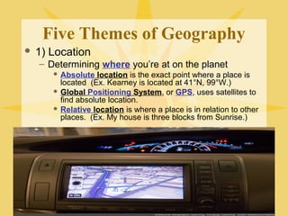
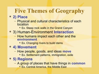
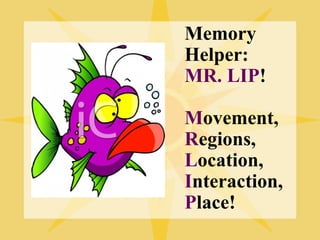
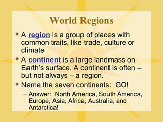
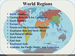
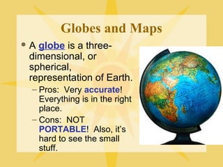
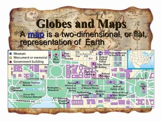
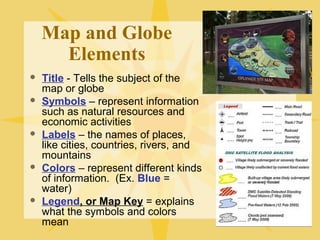
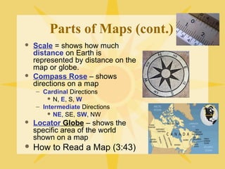
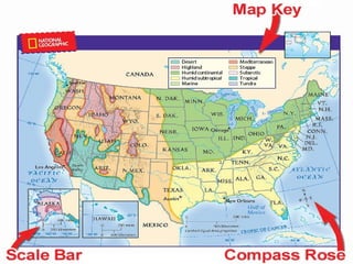
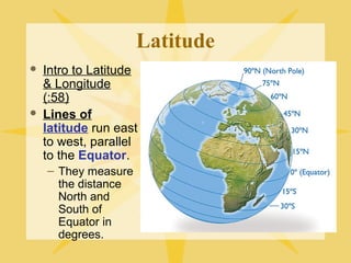
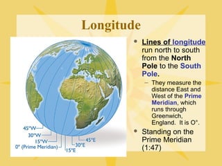
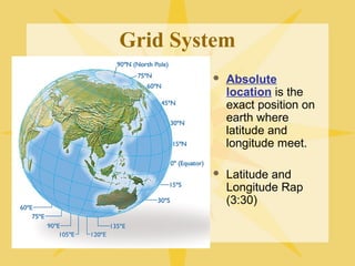
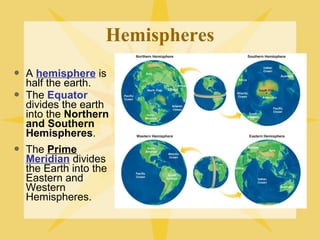
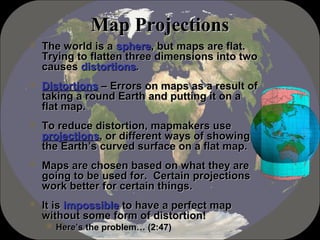
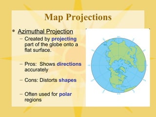
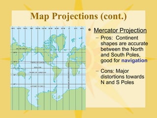
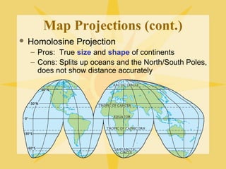
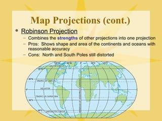
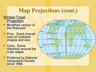
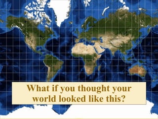
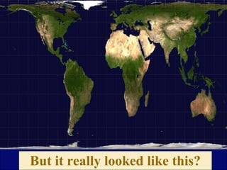
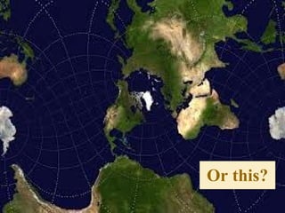
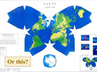
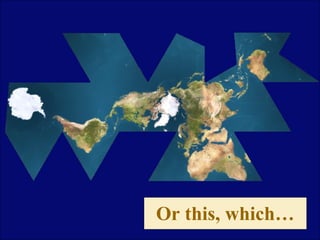
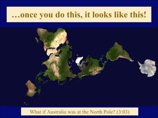
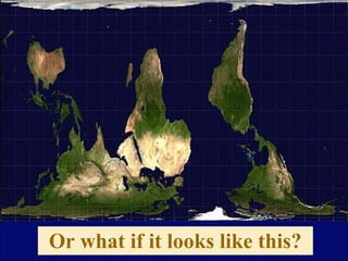
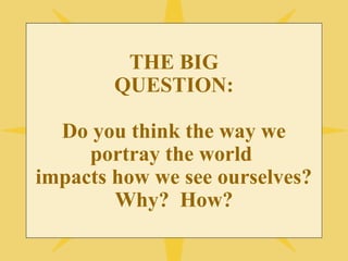
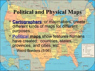
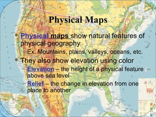
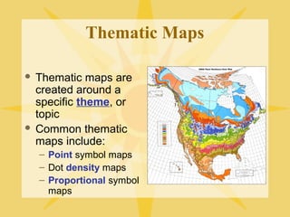
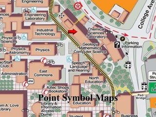
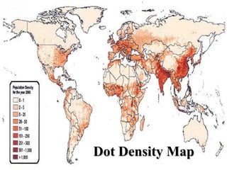
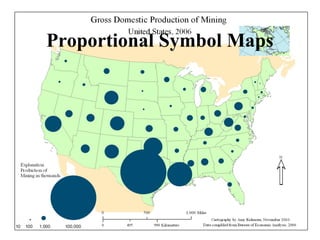
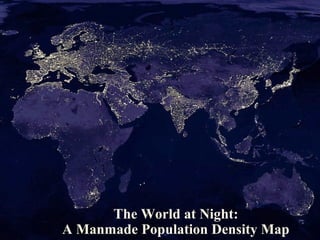
WWoorrlldd CCuullttuurreess && GGeeooggrraapphhyy:: 
TThhee GGeeooggrraapphheerr’’ss 
TToooollbbooxx
Section 1 Objectives 
 Understand spatial thinking and why it’s 
important to geographers 
 Know the five themes of geography and the 
six essential elements 
 Analyze the processes that shaped the 
geographic regions of the world
What IS geography? 
 GGeeooggrraapphhyy is the study of eeaarrtthh in all its 
variety 
– PPhhyyssiiccaall geography: Land, water, plants, 
and animals 
– HHuummaann geography: Society, culture, 
customs, religion, environment 
 Geography is both sscciieennccee and ssttoorryy. 
 Geographers do work that tells the story of all 
humankind! 
 Let the Adventure Begin! (4:00)
Ask Geographic Questions 
Geography is more than names of 
places on a map. It involves spatial 
thinking! 
– Spatial thinking involves thinking about 
the space of Earth’s surface, including 
where places are located, and why they 
are there! 
– Geographers look at places and ask, 
“Why is this location significant, or 
important?”
Study Geographic Patterns 
Geographic patterns are similarities 
among places. 
– Ex. Cities are often located near water. 
Why?
Study Geographic Patterns 
Many geographers 
use computer-based 
Geographic 
Information 
Systems, or GIS to 
create maps and 
analyze patterns with 
data 
 GPS and GIS Basics (4:07)
Five Themes of Geography 
 1) Location 
– Determining where you’re at on the planet 
 Absolute location is the exact point where a place is 
located (Ex. Kearney is located at 41°N, 99°W.) 
 Global Positioning System, or GPS, uses satellites to 
find absolute location. 
 Relative location is where a place is in relation to other 
places. (Ex. My house is three blocks from Sunrise.)
Five Themes of Geography 
 2) Place 
– Physical and cultural characteristics of each 
location 
 Ex. Steep rock walls in the Grand Canyon 
 3) Human-Environment Interaction 
– How humans impact each other and the 
environment 
 Ex. Changing rivers to build dams 
 4) Movement 
– How people, goods, and ideas move 
 Ex. Settlement patterns, immigration, exile 
 5) Regions 
– A group of places that have things in common 
 Ex. Central America, the Middle East
Memory 
Helper: 
MR. LIP! 
Movement, 
Regions, 
Location, 
Interaction, 
Place!
World Regions 
A region is a group of places with 
common traits, like trade, culture or 
climate 
A continent is a large landmass on 
Earth’s surface. A continent is often – 
but not always – a region. 
Name the seven continents: GO! 
– Answer: North America, South America, 
Europe, Asia, Africa, Australia, and 
Antarctica!
World Regions 
 North America 
 Central America & the Caribbean 
 South America 
 Europe 
 Russia and the Eurasian Republics 
 Southwest Asia and North Africa 
 Sub-Saharan Africa 
 South Asia 
 East Asia 
 Southeast Asia 
 Australia, the Pacific Realm, and Antarctica
Section 2 Objectives 
 Understand the essentials of maps and how 
they show geographic patterns 
 Utilize longitude and latitude coordinates to 
establish absolute locations 
 Compare political and physical maps 
 Understand map distortion, and analyze the 
pros and cons of various map projections 
 Identify various types of thematic maps and 
the information they provide
Globes and Maps 
A globe is a three-dimensional, 
or 
spherical, 
representation of Earth. 
– Pros: Very accurate! 
Everything is in the right 
place. 
– Cons: NOT 
PORTABLE! Also, it’s 
hard to see the small 
stuff.
GGlloobbeess aanndd MMaappss 
AA mmaapp iiss aa ttwwoo--ddiimmeennssiioonnaall,, oorr ffllaatt,, 
rreepprreesseennttaattiioonn ooff EEaarrtthh
Map and Globe 
Elements 
 Title - Tells the subject of the 
map or globe 
 Symbols – represent information 
such as natural resources and 
economic activities 
 Labels – the names of places, 
like cities, countries, rivers, and 
mountains 
 Colors – represent different kinds 
of information. (Ex. Blue = 
water) 
 Legend, or Map Key = explains 
what the symbols and colors 
mean
Parts of Maps (cont.) 
 Scale = shows how much 
distance on Earth is 
represented by distance on the 
map or globe. 
 Compass Rose – shows 
directions on a map 
– Cardinal Directions 
 N, E, S, W 
– Intermediate Directions 
 NE, SE, SW, NW 
 Locator Globe – shows the 
specific area of the world 
shown on a map 
 How to Read a Map (3:43)
Latitude 
 Intro to Latitude 
& Longitude 
(:58) 
 Lines of 
latitude run east 
to west, parallel 
to the Equator. 
– They measure 
the distance 
North and 
South of 
Equator in 
degrees.
Longitude 
 Lines of longitude 
run north to south 
from the North 
Pole to the South 
Pole. 
– They measure the 
distance East and 
West of the Prime 
Meridian, which 
runs through 
Greenwich, 
England. It is O°. 
 Standing on the 
Prime Meridian 
(1:47)
Grid System 
 Absolute 
location is the 
exact position on 
earth where 
latitude and 
longitude meet. 
 Latitude and 
Longitude Rap 
(3:30)
Hemispheres 
 A hemisphere is 
half the earth. 
 The Equator 
divides the earth 
into the Northern 
and Southern 
Hemispheres. 
 The Prime 
Meridian divides 
the Earth into the 
Eastern and 
Western 
Hemispheres.
MMaapp PPrroojjeeccttiioonnss 
 TThhee wwoorrlldd iiss aa sspphheerree,, bbuutt mmaappss aarree ffllaatt.. 
TTrryyiinngg ttoo ffllaatttteenn tthhrreeee ddiimmeennssiioonnss iinnttoo ttwwoo 
ccaauusseess ddiissttoorrttiioonnss.. 
 DDiissttoorrttiioonnss –– EErrrroorrss oonn mmaappss aass aa rreessuulltt ooff 
ttaakkiinngg aa rroouunndd EEaarrtthh aanndd ppuuttttiinngg iitt oonn aa 
ffllaatt mmaapp.. 
 TToo rreedduuccee ddiissttoorrttiioonn,, mmaappmmaakkeerrss uussee 
pprroojjeeccttiioonnss,, oorr ddiiffffeerreenntt wwaayyss ooff sshhoowwiinngg 
tthhee EEaarrtthh’’ss ccuurrvveedd ssuurrffaaccee oonn aa ffllaatt mmaapp.. 
 MMaappss aarree cchhoosseenn bbaasseedd oonn wwhhaatt tthheeyy aarree 
ggooiinngg ttoo bbee uusseedd ffoorr.. CCeerrttaaiinn pprroojjeeccttiioonnss 
wwoorrkk bbeetttteerr ffoorr cceerrttaaiinn tthhiinnggss.. 
 IItt iiss iimmppoossssiibbllee ttoo hhaavvee aa ppeerrffeecctt mmaapp 
wwiitthhoouutt ssoommee ffoorrmm ooff ddiissttoorrttiioonn!! 
HHeerree’’ss tthhee pprroobblleemm…… ((22::4477))
Map Projections 
 Azimuthal Projection 
– Created by projecting 
part of the globe onto a 
flat surface. 
– Pros: Shows directions 
accurately 
– Cons: Distorts shapes 
– Often used for polar 
regions
Map Projections (cont.) 
 Mercator Projection 
– Pros: Continent 
shapes are accurate 
between the North 
and South Poles, 
good for navigation 
– Cons: Major 
distortions towards 
N and S Poles
Map Projections (cont.) 
 Homolosine Projection 
– Pros: True size and shape of continents 
– Cons: Splits up oceans and the North/South Poles, 
does not show distance accurately
Map Projections (cont.) 
 Robinson Projection 
– Combines the strengths of other projections into one projection 
– Pros: Shows shape and area of the continents and oceans with 
reasonable accuracy 
– Cons: North and South Poles still distorted
Map Projections (cont.) 
Winkel-Tripel 
Projection 
 Modified version of 
the Robinson 
 Pros: Good overall 
view of continent 
shapes and size 
 Cons: Some 
distortion around the 
outer edges 
 Preferred by National 
Geographic Society 
since 1998.
So why 
does this 
matter? 
Here's one reason. Are we sending 
messages we don't intend to send?
What if you thought your 
world looked like this?
But it really looked like this?
Or this?
Or this?
Or this?
Or this, which…
…once you do this, it looks like this! 
What if Australia was at the North Pole? (3:03)
Or what if it looks like this?
THE BIG 
QUESTION: 
Do you think the way we 
portray the world 
impacts how we see ourselves? 
Why? How?
Political and Physical Maps 
CCaarrttooggrraapphheerrss, or mapmakers, create 
different kinds of maps for different 
purposes 
Political maps show features humans 
have created: countries, states, 
provinces, and cities, etc. 
– Weird Borders (5:06)
Physical Maps 
Physical maps show natural features of 
physical geography 
– Ex. Mountains, plains, valleys, oceans, etc. 
They also show elevation using color 
– Elevation – the height of a physical feature 
above sea level 
– Relief – the change in elevation from one 
place to another
Thematic Maps 
 Thematic maps are 
created around a 
specific theme, or 
topic 
 Common thematic 
maps include: 
– Point symbol maps 
– Dot density maps 
– Proportional symbol 
maps
PPooiinntt SSyymmbbooll MMaappss
DDoott DDeennssiittyy MMaapp
Proportional Symbol Maps
The World at Night: 
A Manmade Population Density Map
Any questions?

The Geographer's Toolbox

  • 1.
    WWoorrlldd CCuullttuurreess &&GGeeooggrraapphhyy:: TThhee GGeeooggrraapphheerr’’ss TToooollbbooxx
  • 2.
    Section 1 Objectives  Understand spatial thinking and why it’s important to geographers  Know the five themes of geography and the six essential elements  Analyze the processes that shaped the geographic regions of the world
  • 3.
    What IS geography?  GGeeooggrraapphhyy is the study of eeaarrtthh in all its variety – PPhhyyssiiccaall geography: Land, water, plants, and animals – HHuummaann geography: Society, culture, customs, religion, environment  Geography is both sscciieennccee and ssttoorryy.  Geographers do work that tells the story of all humankind!  Let the Adventure Begin! (4:00)
  • 4.
    Ask Geographic Questions Geography is more than names of places on a map. It involves spatial thinking! – Spatial thinking involves thinking about the space of Earth’s surface, including where places are located, and why they are there! – Geographers look at places and ask, “Why is this location significant, or important?”
  • 5.
    Study Geographic Patterns Geographic patterns are similarities among places. – Ex. Cities are often located near water. Why?
  • 6.
    Study Geographic Patterns Many geographers use computer-based Geographic Information Systems, or GIS to create maps and analyze patterns with data  GPS and GIS Basics (4:07)
  • 8.
    Five Themes ofGeography  1) Location – Determining where you’re at on the planet  Absolute location is the exact point where a place is located (Ex. Kearney is located at 41°N, 99°W.)  Global Positioning System, or GPS, uses satellites to find absolute location.  Relative location is where a place is in relation to other places. (Ex. My house is three blocks from Sunrise.)
  • 9.
    Five Themes ofGeography  2) Place – Physical and cultural characteristics of each location  Ex. Steep rock walls in the Grand Canyon  3) Human-Environment Interaction – How humans impact each other and the environment  Ex. Changing rivers to build dams  4) Movement – How people, goods, and ideas move  Ex. Settlement patterns, immigration, exile  5) Regions – A group of places that have things in common  Ex. Central America, the Middle East
  • 10.
    Memory Helper: MR.LIP! Movement, Regions, Location, Interaction, Place!
  • 11.
    World Regions Aregion is a group of places with common traits, like trade, culture or climate A continent is a large landmass on Earth’s surface. A continent is often – but not always – a region. Name the seven continents: GO! – Answer: North America, South America, Europe, Asia, Africa, Australia, and Antarctica!
  • 12.
    World Regions North America  Central America & the Caribbean  South America  Europe  Russia and the Eurasian Republics  Southwest Asia and North Africa  Sub-Saharan Africa  South Asia  East Asia  Southeast Asia  Australia, the Pacific Realm, and Antarctica
  • 13.
    Section 2 Objectives  Understand the essentials of maps and how they show geographic patterns  Utilize longitude and latitude coordinates to establish absolute locations  Compare political and physical maps  Understand map distortion, and analyze the pros and cons of various map projections  Identify various types of thematic maps and the information they provide
  • 14.
    Globes and Maps A globe is a three-dimensional, or spherical, representation of Earth. – Pros: Very accurate! Everything is in the right place. – Cons: NOT PORTABLE! Also, it’s hard to see the small stuff.
  • 15.
    GGlloobbeess aanndd MMaappss AA mmaapp iiss aa ttwwoo--ddiimmeennssiioonnaall,, oorr ffllaatt,, rreepprreesseennttaattiioonn ooff EEaarrtthh
  • 16.
    Map and Globe Elements  Title - Tells the subject of the map or globe  Symbols – represent information such as natural resources and economic activities  Labels – the names of places, like cities, countries, rivers, and mountains  Colors – represent different kinds of information. (Ex. Blue = water)  Legend, or Map Key = explains what the symbols and colors mean
  • 17.
    Parts of Maps(cont.)  Scale = shows how much distance on Earth is represented by distance on the map or globe.  Compass Rose – shows directions on a map – Cardinal Directions  N, E, S, W – Intermediate Directions  NE, SE, SW, NW  Locator Globe – shows the specific area of the world shown on a map  How to Read a Map (3:43)
  • 19.
    Latitude  Introto Latitude & Longitude (:58)  Lines of latitude run east to west, parallel to the Equator. – They measure the distance North and South of Equator in degrees.
  • 20.
    Longitude  Linesof longitude run north to south from the North Pole to the South Pole. – They measure the distance East and West of the Prime Meridian, which runs through Greenwich, England. It is O°.  Standing on the Prime Meridian (1:47)
  • 21.
    Grid System Absolute location is the exact position on earth where latitude and longitude meet.  Latitude and Longitude Rap (3:30)
  • 22.
    Hemispheres  Ahemisphere is half the earth.  The Equator divides the earth into the Northern and Southern Hemispheres.  The Prime Meridian divides the Earth into the Eastern and Western Hemispheres.
  • 23.
    MMaapp PPrroojjeeccttiioonnss TThhee wwoorrlldd iiss aa sspphheerree,, bbuutt mmaappss aarree ffllaatt.. TTrryyiinngg ttoo ffllaatttteenn tthhrreeee ddiimmeennssiioonnss iinnttoo ttwwoo ccaauusseess ddiissttoorrttiioonnss..  DDiissttoorrttiioonnss –– EErrrroorrss oonn mmaappss aass aa rreessuulltt ooff ttaakkiinngg aa rroouunndd EEaarrtthh aanndd ppuuttttiinngg iitt oonn aa ffllaatt mmaapp..  TToo rreedduuccee ddiissttoorrttiioonn,, mmaappmmaakkeerrss uussee pprroojjeeccttiioonnss,, oorr ddiiffffeerreenntt wwaayyss ooff sshhoowwiinngg tthhee EEaarrtthh’’ss ccuurrvveedd ssuurrffaaccee oonn aa ffllaatt mmaapp..  MMaappss aarree cchhoosseenn bbaasseedd oonn wwhhaatt tthheeyy aarree ggooiinngg ttoo bbee uusseedd ffoorr.. CCeerrttaaiinn pprroojjeeccttiioonnss wwoorrkk bbeetttteerr ffoorr cceerrttaaiinn tthhiinnggss..  IItt iiss iimmppoossssiibbllee ttoo hhaavvee aa ppeerrffeecctt mmaapp wwiitthhoouutt ssoommee ffoorrmm ooff ddiissttoorrttiioonn!! HHeerree’’ss tthhee pprroobblleemm…… ((22::4477))
  • 24.
    Map Projections Azimuthal Projection – Created by projecting part of the globe onto a flat surface. – Pros: Shows directions accurately – Cons: Distorts shapes – Often used for polar regions
  • 25.
    Map Projections (cont.)  Mercator Projection – Pros: Continent shapes are accurate between the North and South Poles, good for navigation – Cons: Major distortions towards N and S Poles
  • 26.
    Map Projections (cont.)  Homolosine Projection – Pros: True size and shape of continents – Cons: Splits up oceans and the North/South Poles, does not show distance accurately
  • 27.
    Map Projections (cont.)  Robinson Projection – Combines the strengths of other projections into one projection – Pros: Shows shape and area of the continents and oceans with reasonable accuracy – Cons: North and South Poles still distorted
  • 28.
    Map Projections (cont.) Winkel-Tripel Projection  Modified version of the Robinson  Pros: Good overall view of continent shapes and size  Cons: Some distortion around the outer edges  Preferred by National Geographic Society since 1998.
  • 29.
    So why doesthis matter? Here's one reason. Are we sending messages we don't intend to send?
  • 30.
    What if youthought your world looked like this?
  • 31.
    But it reallylooked like this?
  • 32.
  • 33.
  • 34.
  • 35.
  • 36.
    …once you dothis, it looks like this! What if Australia was at the North Pole? (3:03)
  • 37.
    Or what ifit looks like this?
  • 38.
    THE BIG QUESTION: Do you think the way we portray the world impacts how we see ourselves? Why? How?
  • 39.
    Political and PhysicalMaps CCaarrttooggrraapphheerrss, or mapmakers, create different kinds of maps for different purposes Political maps show features humans have created: countries, states, provinces, and cities, etc. – Weird Borders (5:06)
  • 40.
    Physical Maps Physicalmaps show natural features of physical geography – Ex. Mountains, plains, valleys, oceans, etc. They also show elevation using color – Elevation – the height of a physical feature above sea level – Relief – the change in elevation from one place to another
  • 41.
    Thematic Maps Thematic maps are created around a specific theme, or topic  Common thematic maps include: – Point symbol maps – Dot density maps – Proportional symbol maps
  • 42.
  • 43.
  • 44.
  • 45.
    The World atNight: A Manmade Population Density Map
  • 46.