Paper presented in the research methodology workshop. The error if any is regretted and suggestions most welcome. Good for students and researchers alike, enjoy.
Map is a drawn or printed representation of the physical features of the Earth.
It is the best tool to show, understand and analyse the features of an area. Cartography is the art and science of making maps. This module highlights many information on maps, types and their uses.
Topics:
1. Mapping Concepts
2. Analysis with paper based Maps
3. Limitations of Paper based Maps
4. Computer Aided Cartography History and Development
5. GIS Definition
6. Advantage of Digital Maps
1. Name _____________________________ Date ________________ Ntbk# _______
Study Guide — Map Skills
Match the word with its definition.
Write the letter of the definition on the
blank.
1. C Cartography
2. F Equator
3. E Hemisphere
4. B Compass Rose
5. A Map Key/Legend
6. D Scale
7. G Inset Map
8. H Physical Map
9. J Political Map
10. I Prime Meridian
A. Interprets the symbols on a map
B. Indicates cardinal and intermediate directions
on a map.
C. The art of mapmaking
D. Provides a tool for measuring the distance between
locations on a map
E. Half of the Earth
F. Located at 0° latitude, this imaginary line separates
the Earth into the Northern and Southern Hemi-spheres.
G. A smaller map that often provides more detail or
enlarges an area of the larger map.
H. A map that shows landforms, water features, and
topography of a location.
I. This Located at 0° longitude, this imaginary line sep-arates
the Earth into the Eastern and Western Hemi-spheres.
J. A map that shows borders, cities, roads, and other
man-made features of a location.
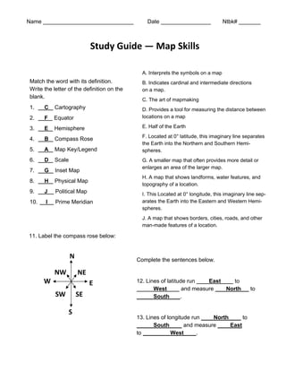
11. Label the compass rose below:
Complete the sentences below.
12. Lines of latitude run East to
West and measure North to
South .
13. Lines of longitude run North to
South and measure East
to West .
N
NE
NW
W E
SW SE
S