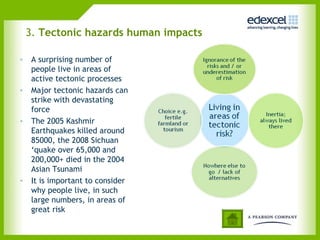
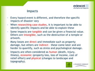
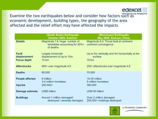
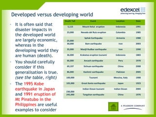
6GEO4 Unit 4 Tectonic Activity and Hazards
What is this option about?
• The Tectonic Activity and
Hazards option focuses on the
range of natural hazards
generated by plate tectonics
• In addition to understanding
why these hazards happen,
you will need to understand:
• The impact of tectonic
processes on the landscape
• The impact of tectonic hazards
on people
• The ways in which people
respond to, and try to manage,
natural hazards.
Primary hazards Secondary
hazards
Earthquakes Tsunami
Landslides
Liquefaction
Volcanoes Lahars
Landslides
Tsunami
1. Tectonic activity and causes
2. Tectonic hazards physical impacts
3. Tectonic hazards human impacts
4. Response to tectonic hazards
CONTENTS
Click on the information icon to jump to that section.
Click on the home button to return to this contents page
1. Tectonic activity and causes
• Tectonic activity can produce a
very large range of hazard events
• Not all of these events are
‘disasters’
• A natural hazard event becomes
a disaster when the event causes
a significant impact on a
vulnerable population.
• These impacts could be human
(death, injury) and / or economic
(property losses, loss of income).
• Definitions vary, but ‘significant’
losses usually means 10+ deaths /
100+ affected / $1 million losses.
The Dregg disaster model
Event profiles
• Not all tectonic hazards are the same
• Event profiles are a common way of comparing
different hazards
• In this example the 2004 Asian Tsunami and ongoing
eruption of Kilauea on Hawaii are compared
• Hazard profiles can be drawn for any event.
Earth’s heat engine
• Tectonic processes are
driven by radioactive
decay in the core
• This decay generates
heat inside the earth,
which drives vast
convection currents
• This convection is
largely responsible for
plate movement
Tectonic settings and plates
• Most tectonic hazards are concentrated at plate margins
(boundaries), although ‘hotspots’ are a notable exception.
• Different types of boundary generate very different tectonic
hazards.
The range of volcanic hazards
• Dangerous volcanic
hazards are found
along subduction
zones at destructive
plate margins
• The most dangerous
volcanoes are
themselves multiple
hazard areas.
• Volcanoes at
constructive plate
margins (Iceland) and
oceanic
hotspots(Hawaii) are
much less hazardous
and destructive.
Magma generation
Magma
type
Generation Tectonic setting Hazards
Basaltic
Low silica, low gas, low
viscosity.
Dry partial melting of
upper mantle
Oceanic Hot spot (Hawaii)
Constructive (Iceland)
Lava flow
Andesitic
Intermediate
Wet partial melting of
subducting plates
Destructive plate margin
(Andes)
Island arc margin
(Montserrat)
Lava flow, ash and tephra,
pyroclastic flow, lahar, gas
emission
Rhyolitic
High silica, high gas, high
viscosity.
In situ melting of
lower continental
crust
(very rare eruptions)
Continental Hot spot
(Yellowstone)
Continent collision zone
(Himalayas)
Cataclysmic explosion,
pyroclastic flow
• Magma, molten rock in the earth’s crust, has an important relationship
with volcanic explosivity and hazard level
• Andesitic magmas, formed by wet partial melting at subduction zones
produce highly explosive and destructive composite volcanoes
Measuring volcanic explosivity:
• The Volcanic
Explosivity Index (VEI)
is used to measure
volcanic power.
• VEI measures: Volume
of ejecta Height of the
eruption column
Duration of the
eruption.
• Modern humans have
never experienced a
VEI 7 or 8
Earthquakes
• Earthquakes are a very
common, sudden release of
energy that generate seismic
waves
• Most occur along faults (cracks
in the earth’s crust) which
become ‘locked’
• Opposing tectonic forces push
against the locked fault,
building up strain, which
eventually gives way releasing
stored energy
• This energy spreads out rapidly
from the earthquake origin (the
focus) reaching the surface at
the epicentre, and then
spreading horizontally.
Tsunami
• Tsunami are relatively rare events.
• They are generated by submarine earthquakes, volcanic collapse, and
coastal landslides, which suddenly displace huge volumes of water
• The 1993 Okushiri tsunami (Japan), 2004 Asian Tsunami and 2009 Samoa
events are all useful as case studies.
• Tsunami waves are radically different from normal wind generated ocean
waves.
• When a tsunami hits a coastline, the effect is more like a devastating
coastal flood than a single breaking waves
2. Tectonic hazards physical impacts
• Tectonic processes play a key
role in forming the landscape
around us
• Volcanic activity and the
movement of tectonic plates
create mountains, plateaux
and other landscape features
• These landscapes are then
modified by
geomorphological processes
(weathering, rivers, ice, wind
and slope processes)
Magma type and volcano morphology
• Volcanoes are extrusive igneous landforms. The form of volcanoes
is related to magma types, and therefore to different tectonic
settings:
• Basaltic – huge, low relief shield volcanoes plus small scoria cones
and fissure vents.
• Andesitic – steep sided strato-volcanoes; layers of lava, ash and
tephra.
• Rhyolitic – central craters with lava plugs / domes, due to high
viscosity of the lava. Calderas and collapse calderas.
Extrusive igneous activity
• Large scale outpourings of basaltic magma, called flood basalts,
have occurred at various times in the past.
• These produce distinctive lava plateaux and stepped or ‘trap’
topography
Intrusive igneous activity
• The injection (intrusion) of magma below the surface can
produce characteristic landforms
• Igneous rock normally resists weathering and erosion in
comparison to surrounding rocks, which produces positive relief
features.
• Large intrusions such as batholiths produce upland areas,
whereas minor intrusions produce smaller landscape features
Earthquakes and
faults
• Tectonic movements and movements along faults (which
generate earthquakes) also produce distinctive landforms and
relief:
Note: diagram not to scale
3. Tectonic hazards human impacts
• A surprising number of
people live in areas of
active tectonic processes
• Major tectonic hazards can
strike with devastating
force
• The 2005 Kashmir
Earthquakes killed around
85000, the 2008 Sichuan
‘quake over 65,000 and
200,000+ died in the 2004
Asian Tsunami
• It is important to consider
why people live, in such
large numbers, in areas of
great risk
Impacts
• Every hazard event is different, and therefore the specific
impacts of disaster vary
• When researching case studies, it is important to be able to
identify specific impacts and be able to explain these
• Some impacts are tangible and can be given a financial value.
Others are intangible, such as the destruction of a temple or
artwork.
• Many losses are direct and immediate such as property
damage, but others are indirect – these come later and are
harder to quantify, such as stress and psychological damage.
• Impacts are often considered as human (death, injury,
illness), economic (property loss, loss of income, cost of
relief effort) and physical (changes to landscape and
topography).
• Examine the two earthquakes below and consider how factors such as
economic development, building types, the geography of the area
affected and the relief effort may have affected the impacts
(South Asian) Earthquake
October 2005, Kashmir
(Wenchuan) Earthquake
May 2008, Sichuan, China
Details Magnitude 7.6. Huge number of
landslides accounting for 30%+
of deaths
Magnitude 8.0. Thrust fault at continent
continent convergence
Fault
displacement
Largely horizontal
displacement of up to 10m
Up to 5m vertically and 4m horizontally at the
surface
Focus depth 10 km 19 km
Aftershocks 900+ over magnitude 4.0 250+ aftershocks over magnitude 4.0
Deaths 80,000 70,000
People affected 8 million
3-4 million homeless
15-30 million
5 million homeless
Injuries 200,000+ 380,000
Damage estimate US$5 billion US$150 billion
Buildings Around 1 million damaged/
destroyed / severely damaged
Over 2 million damaged
200,000+ buildings destroyed
Developed versus developing world
• It is often said that
disaster impacts in
the developed world
are largely economic,
whereas in the
developing world they
are human (death).
• You should carefully
consider if this
generalisation is true.
(see the table, right)
• The 1995 Kobe
earthquake in Japan
and 1991 eruption of
Mt Pinatubo in the
Philippines are useful
examples to consider
Death Toll Event Location Date
5,115 Mount Kelut eruption Indonesia 1991
23,000 Nevado del Ruiz eruption Colombia 1985
25,000
Spitak Earthquake Armenia 1988
30,000 Bam earthquake Iran 2003
35,000 Manjil Rudbar earthquake Iran 1990
36,000 Krakatoa eruption tsunami Indonesia 1883
66,000 Ancash earthquake Peru 1970
69,197 Sichuan earthquake China 2008
86,000 Kashmir earthquake Pakistan 2005
100,000 Tsunami Messina, Italy 1908
105,000 Great Kanto earthquake Japan 1923
230,000
Indian Ocean tsunami Indian Ocean 2004
245,000 Tangshan earthquake China 1976
Impacts over time
• A simplified version of Park’s hazard response model is shown
below
• Different hazard events have different impacts, shown by the
speed of the drop in quality of life, the duration of the decline,
and the speed and nature of recovery.
• The differences in the 3 lines might be related to type of
hazard, degree of preparedness, speed of the relief effort and
the nature of recovery and rebuilding.
4. Response to tectonic hazards
• People cope with natural
hazards in very different ways
• The chosen ways are often
related to wealth and access
to technology
• Humans do have a capacity to
ignore or seriously
underestimate risk, even when
it seems obvious to others
• Often it may seem obvious that
people should move out of
harms way, but in reality this
may be impossible.
Hazard modification
• Several different approaches can be taken to reduce the impacts of
tectonic hazards:
Modify the
event
(hazard
mitigation)
Modify human
vulnerability
Modify the
loss
Tsunami Coastal defences
and engineering
•Warming and prediction systems
•Coastal zone management and
landuse planning
•Provision of emergency kits
Loss modification
involves immediate
rescue efforts,
followed by relief
efforts which focus
on food, shelter,
water and
sanitation.
Insurance can help
recovery.
Long term
reconstruction is
needed.
Earthquakes Not possible •Ground shaking and liquefaction
risk mapping
•Aseismic buildings
•Earthquake education and drills
•Prediction not possible
Volcanoes Lava diversion •Monitoring, prediction warning
and evacuation systems
•Hazard mapping e.g. lahar risk
•Education
•Shelters
The hazard management cycle
• Successful hazard
management involves a cycle
(see diagram) which focuses
on the 3 types of modification
from the previous slide.
• A focus on modifying loss only,
will not improve survival
chances when the next hazard
strikes
• Long before a natural hazard
event, there needs to be a
focus on mitigation and
prevention (if possible) as well
as human preparedness.

Tectonic-activity-and-hazards

  • 1.
    6GEO4 Unit 4Tectonic Activity and Hazards
  • 2.
    What is thisoption about? • The Tectonic Activity and Hazards option focuses on the range of natural hazards generated by plate tectonics • In addition to understanding why these hazards happen, you will need to understand: • The impact of tectonic processes on the landscape • The impact of tectonic hazards on people • The ways in which people respond to, and try to manage, natural hazards. Primary hazards Secondary hazards Earthquakes Tsunami Landslides Liquefaction Volcanoes Lahars Landslides Tsunami
  • 3.
    1. Tectonic activityand causes 2. Tectonic hazards physical impacts 3. Tectonic hazards human impacts 4. Response to tectonic hazards CONTENTS Click on the information icon to jump to that section. Click on the home button to return to this contents page
  • 4.
    1. Tectonic activityand causes • Tectonic activity can produce a very large range of hazard events • Not all of these events are ‘disasters’ • A natural hazard event becomes a disaster when the event causes a significant impact on a vulnerable population. • These impacts could be human (death, injury) and / or economic (property losses, loss of income). • Definitions vary, but ‘significant’ losses usually means 10+ deaths / 100+ affected / $1 million losses. The Dregg disaster model
  • 5.
    Event profiles • Notall tectonic hazards are the same • Event profiles are a common way of comparing different hazards • In this example the 2004 Asian Tsunami and ongoing eruption of Kilauea on Hawaii are compared • Hazard profiles can be drawn for any event.
  • 6.
    Earth’s heat engine •Tectonic processes are driven by radioactive decay in the core • This decay generates heat inside the earth, which drives vast convection currents • This convection is largely responsible for plate movement
  • 7.
    Tectonic settings andplates • Most tectonic hazards are concentrated at plate margins (boundaries), although ‘hotspots’ are a notable exception. • Different types of boundary generate very different tectonic hazards.
  • 8.
    The range ofvolcanic hazards • Dangerous volcanic hazards are found along subduction zones at destructive plate margins • The most dangerous volcanoes are themselves multiple hazard areas. • Volcanoes at constructive plate margins (Iceland) and oceanic hotspots(Hawaii) are much less hazardous and destructive.
  • 9.
    Magma generation Magma type Generation Tectonicsetting Hazards Basaltic Low silica, low gas, low viscosity. Dry partial melting of upper mantle Oceanic Hot spot (Hawaii) Constructive (Iceland) Lava flow Andesitic Intermediate Wet partial melting of subducting plates Destructive plate margin (Andes) Island arc margin (Montserrat) Lava flow, ash and tephra, pyroclastic flow, lahar, gas emission Rhyolitic High silica, high gas, high viscosity. In situ melting of lower continental crust (very rare eruptions) Continental Hot spot (Yellowstone) Continent collision zone (Himalayas) Cataclysmic explosion, pyroclastic flow • Magma, molten rock in the earth’s crust, has an important relationship with volcanic explosivity and hazard level • Andesitic magmas, formed by wet partial melting at subduction zones produce highly explosive and destructive composite volcanoes
  • 10.
    Measuring volcanic explosivity: •The Volcanic Explosivity Index (VEI) is used to measure volcanic power. • VEI measures: Volume of ejecta Height of the eruption column Duration of the eruption. • Modern humans have never experienced a VEI 7 or 8
  • 11.
    Earthquakes • Earthquakes area very common, sudden release of energy that generate seismic waves • Most occur along faults (cracks in the earth’s crust) which become ‘locked’ • Opposing tectonic forces push against the locked fault, building up strain, which eventually gives way releasing stored energy • This energy spreads out rapidly from the earthquake origin (the focus) reaching the surface at the epicentre, and then spreading horizontally.
  • 12.
    Tsunami • Tsunami arerelatively rare events. • They are generated by submarine earthquakes, volcanic collapse, and coastal landslides, which suddenly displace huge volumes of water • The 1993 Okushiri tsunami (Japan), 2004 Asian Tsunami and 2009 Samoa events are all useful as case studies. • Tsunami waves are radically different from normal wind generated ocean waves. • When a tsunami hits a coastline, the effect is more like a devastating coastal flood than a single breaking waves
  • 13.
    2. Tectonic hazardsphysical impacts • Tectonic processes play a key role in forming the landscape around us • Volcanic activity and the movement of tectonic plates create mountains, plateaux and other landscape features • These landscapes are then modified by geomorphological processes (weathering, rivers, ice, wind and slope processes)
  • 14.
    Magma type andvolcano morphology • Volcanoes are extrusive igneous landforms. The form of volcanoes is related to magma types, and therefore to different tectonic settings: • Basaltic – huge, low relief shield volcanoes plus small scoria cones and fissure vents. • Andesitic – steep sided strato-volcanoes; layers of lava, ash and tephra. • Rhyolitic – central craters with lava plugs / domes, due to high viscosity of the lava. Calderas and collapse calderas.
  • 15.
    Extrusive igneous activity •Large scale outpourings of basaltic magma, called flood basalts, have occurred at various times in the past. • These produce distinctive lava plateaux and stepped or ‘trap’ topography
  • 16.
    Intrusive igneous activity •The injection (intrusion) of magma below the surface can produce characteristic landforms • Igneous rock normally resists weathering and erosion in comparison to surrounding rocks, which produces positive relief features. • Large intrusions such as batholiths produce upland areas, whereas minor intrusions produce smaller landscape features
  • 17.
    Earthquakes and faults • Tectonicmovements and movements along faults (which generate earthquakes) also produce distinctive landforms and relief: Note: diagram not to scale
  • 18.
    3. Tectonic hazardshuman impacts • A surprising number of people live in areas of active tectonic processes • Major tectonic hazards can strike with devastating force • The 2005 Kashmir Earthquakes killed around 85000, the 2008 Sichuan ‘quake over 65,000 and 200,000+ died in the 2004 Asian Tsunami • It is important to consider why people live, in such large numbers, in areas of great risk
  • 19.
    Impacts • Every hazardevent is different, and therefore the specific impacts of disaster vary • When researching case studies, it is important to be able to identify specific impacts and be able to explain these • Some impacts are tangible and can be given a financial value. Others are intangible, such as the destruction of a temple or artwork. • Many losses are direct and immediate such as property damage, but others are indirect – these come later and are harder to quantify, such as stress and psychological damage. • Impacts are often considered as human (death, injury, illness), economic (property loss, loss of income, cost of relief effort) and physical (changes to landscape and topography).
  • 20.
    • Examine thetwo earthquakes below and consider how factors such as economic development, building types, the geography of the area affected and the relief effort may have affected the impacts (South Asian) Earthquake October 2005, Kashmir (Wenchuan) Earthquake May 2008, Sichuan, China Details Magnitude 7.6. Huge number of landslides accounting for 30%+ of deaths Magnitude 8.0. Thrust fault at continent continent convergence Fault displacement Largely horizontal displacement of up to 10m Up to 5m vertically and 4m horizontally at the surface Focus depth 10 km 19 km Aftershocks 900+ over magnitude 4.0 250+ aftershocks over magnitude 4.0 Deaths 80,000 70,000 People affected 8 million 3-4 million homeless 15-30 million 5 million homeless Injuries 200,000+ 380,000 Damage estimate US$5 billion US$150 billion Buildings Around 1 million damaged/ destroyed / severely damaged Over 2 million damaged 200,000+ buildings destroyed
  • 21.
    Developed versus developingworld • It is often said that disaster impacts in the developed world are largely economic, whereas in the developing world they are human (death). • You should carefully consider if this generalisation is true. (see the table, right) • The 1995 Kobe earthquake in Japan and 1991 eruption of Mt Pinatubo in the Philippines are useful examples to consider Death Toll Event Location Date 5,115 Mount Kelut eruption Indonesia 1991 23,000 Nevado del Ruiz eruption Colombia 1985 25,000 Spitak Earthquake Armenia 1988 30,000 Bam earthquake Iran 2003 35,000 Manjil Rudbar earthquake Iran 1990 36,000 Krakatoa eruption tsunami Indonesia 1883 66,000 Ancash earthquake Peru 1970 69,197 Sichuan earthquake China 2008 86,000 Kashmir earthquake Pakistan 2005 100,000 Tsunami Messina, Italy 1908 105,000 Great Kanto earthquake Japan 1923 230,000 Indian Ocean tsunami Indian Ocean 2004 245,000 Tangshan earthquake China 1976
  • 22.
    Impacts over time •A simplified version of Park’s hazard response model is shown below • Different hazard events have different impacts, shown by the speed of the drop in quality of life, the duration of the decline, and the speed and nature of recovery. • The differences in the 3 lines might be related to type of hazard, degree of preparedness, speed of the relief effort and the nature of recovery and rebuilding.
  • 23.
    4. Response totectonic hazards • People cope with natural hazards in very different ways • The chosen ways are often related to wealth and access to technology • Humans do have a capacity to ignore or seriously underestimate risk, even when it seems obvious to others • Often it may seem obvious that people should move out of harms way, but in reality this may be impossible.
  • 24.
    Hazard modification • Severaldifferent approaches can be taken to reduce the impacts of tectonic hazards: Modify the event (hazard mitigation) Modify human vulnerability Modify the loss Tsunami Coastal defences and engineering •Warming and prediction systems •Coastal zone management and landuse planning •Provision of emergency kits Loss modification involves immediate rescue efforts, followed by relief efforts which focus on food, shelter, water and sanitation. Insurance can help recovery. Long term reconstruction is needed. Earthquakes Not possible •Ground shaking and liquefaction risk mapping •Aseismic buildings •Earthquake education and drills •Prediction not possible Volcanoes Lava diversion •Monitoring, prediction warning and evacuation systems •Hazard mapping e.g. lahar risk •Education •Shelters
  • 25.
    The hazard managementcycle • Successful hazard management involves a cycle (see diagram) which focuses on the 3 types of modification from the previous slide. • A focus on modifying loss only, will not improve survival chances when the next hazard strikes • Long before a natural hazard event, there needs to be a focus on mitigation and prevention (if possible) as well as human preparedness.