Downloaded 19 times
![Streamflow simulation using radar-based precipitation data
applied to the Illinois River basin, USA
Alireza Safari and F. De Smedt
Department of Hydrology and Hydraulic Engineering,Vrije Universiteit Brussel
Pleinlaan 2, 1050 Brussels, Belgium
February 19, 2008
Abstract
This paper describes the application of a spatially distributed hydrological model WetSpa (Water
and Energy Transfer between Soil, Plants and Atmosphere) using radar-based rainfall data provide by
the United States Hydrology Laboratory of NOAA’s National Weather Service for a distributed model
intercomparison project. The model is applied to the Illinois river basin above Tahlequah hydrometry
station with 30-m spatial resolution and one hour time–step for a total simulation period of 6 years.
Rainfall inputs are derived from radar. The distributed model parameters are based on an extensive
database of watershed characteristics available for the region, including digital maps of DEM, soil type,
and land use. The model is calibrated and validated on part of the river flow records. The simulated
hydrograph shows a good correspondence with observation, indicating that the model is able to simulate
the relevant hydrologic processes in the basin accurately.
Keywords: WetSpa, Physically-based Distributed Hydrologic Model, DMIP, NEXRAD Stage III rainfall data, Stream-
flow Simulation, PEST, Illinois River basin.
1 Introduction
Rainfall–runoff models are used and developed by hydrologists to model rainfall–runoff processes. The
NOAA–sponsored Distributed Model Intercomparison Project (DMIP) provides a forum to explore the
applicability of distributed models using operational quality data in order to improve flow modeling and
prediction along the entire river system [Smith, 2002, Smith, 2004, Smith et al., 2004].
The US National Weather Service’s (NWS) Next Generation Weather Radar WSR-88D (NEXRAD) precip-
itation products are widely used in hydrometeorology and climatology for rainfall estimation [Ciach et al.,
1997, Seo et al., 1999, Krajewsk and Smith, 2002, Uijlenhoet et al., 2003], precipitation and weather fore-
casting [Johnson et al., 1998,Grecu and Krajewski, 2000] and flood forecasting [Johnson et al., 1999,Young
et al., 2000, Smith et al., 2005, Reed et al., 2007]. The most commonly NEXRAD product in hydrometeo-
rological applications is the NEXRAD Stage III data, since it involves the correction of radar rainfall rates
with multiple surface rain gauges and has a significant degree of meteorological quality control [R.A.Fulton
1](https://image.slidesharecdn.com/balwois2008-120507164456-phpapp01/75/Streamflow-simulation-using-radar-based-precipitation-applied-to-the-Illinois-River-basin-in-Oklahoma-USA-1-2048.jpg)
![BALWOIS 2008-Ohrid, Republic of Macedonia- 27, 31 May 2008 2
et al., 1998]. However, because the Stage III products consist of high-resolution spatial-temporal precipi-
tation data over large regions, it is difficult to use in conjunction with other geospatial products [Reed and
Maidment, 1995, Reed and Maidment, 1999]. The nominal size of an HRAP grid cell is 4 km by 4 km and
the temporal resolution of these grids is 1-hour. The grid data is provided in binary XMRG format [Office
of Hydrologic Development, 2006].
Distributed hydrological models are usually parameterized by deriving estimates of parameters from topog-
raphy and physical properties of the soils, aquifers and land use in the basin. In recent years, a number of
methods have been developed for the estimation of hydrologic model parameters. One frequently used and
relatively simple algorithm is the parameter estimation PEST method. This automatic calibration procedure
uses a nonlinear estimation technique known as the Gauss-Marquardt-Levenberg method. The strength of
this method lies in the fact that it can generally estimate parameter values using fewer model runs than
any other method. The program is able to run a model as many times as needed while adjusting parameter
values until the discrepancies between selected model outputs and a complementary set of field or labora-
tory measurements is reduced to a minimum in a weighted least-squares sense. Numerous examples of the
application of the PEST algorithm for the calibration of hydrologic models can be found in the literature
and PEST proves to be a time-saving tool compared to other model calibration techniques [Al-Abed and
Whiteley, 2002, Baginska et al., 2003, Zyvoloski et al., 2003, Doherty and Johnston, 2003, Wang and Me-
lesse, 2005, Liu et al., 2005, Bahremand and De Smedt, 2006, Bahremand and De Smedt, 2007, Goegebeur
and Pauwels, 2007, Nossent and Bauwens, 2007].
A few years ago, the United States Hydrology Laboratory (HL) (then the Hydrologic Research Laboratory)
of NWS began a major research effort called Distributed Model Intercomparison Project (DMIP) to address
the question: how can the NWS best utilize the NEXRAD data to improve its river forecasts? The result
suggested that spatial rainfall averages derived from the NEXRAD data can improve flood prediction in
mid/large basins as compared to gage-only averages [Bandaragoda et al., 2004, Reed et al., 2004, Smith
et al., 2004,Reed et al., 2007]. Previous studies on some of the DMIP basins have shown that calibration of
distributed hydrological models significantly improves simulation results [Ajami et al., 2004, Bandaragoda
et al., 2004, Carpenter and Georgakakos, 2004, Ivanov et al., 2004, Butts et al., 2005].
In this paper, a spatially distributed physically based hydrologic model, WetSpa, is applied to a subwater-
shed of the Illinois River basin which forms part of the DMIP basins [Smith, 2002]. The paper is organized
as follows. First, a brief description of the hydrologic model used in this study is given. Next, model per-
formance indicators are discussed. In section 3, the site and data used are described. Details of the model
calibrations and a comparison of the results are given in section 4. Finally, conclusions that can be drawn
from this work are presented.
2 Methodology
The WetSpa model is capable of predicting runoff and river flow at any gauged and ungauged location in a
watershed on hourly time scale [Wang et al., 1997,De Smedt et al., 2000,Liu et al., 2003,Bahremand et al.,
2006, Zeinivand et al., 2007]. Availability of spatially distributed data sets (digital elevation model, lan-
duse, soil and radar-based precipitation data) coupled with GIS technology enables the WetSpa to perform
spatially distributed calculations. The hydrological processes considered in the model are precipitation,
interception, depression storage, surface runoff, infiltration, evapotranspiration, percolation, interflow and](https://image.slidesharecdn.com/balwois2008-120507164456-phpapp01/75/Streamflow-simulation-using-radar-based-precipitation-applied-to-the-Illinois-River-basin-in-Oklahoma-USA-2-2048.jpg)
![BALWOIS 2008-Ohrid, Republic of Macedonia- 27, 31 May 2008 3
ground water drainage. The total water balance for each raster cell is composed of a separate water balance
for the vegetated, bare-soil, open water, and impervious part of each cell. A mixture of physical and em-
pirical relationships is used to describe the hydrological processes. The model predicts discharges in any
location of the channel network and the spatial distribution of hydrological characteristics. Hydrological
processes are set in a cascading way. Starting from precipitation, incident rainfall first encounters the plant
canopy, which intercepts all or part of the rainfall until the interception storage capacity is reached. Excess
water reaches the soil surface and can infiltrate the soil zone, enter depression storage, or is diverted as
surface runoff. The sum of interception and depression storage forms the initial loss at the beginning of
a storm, and does not contribute to the storm flow. A fraction of the infiltrated water percolates to the
groundwater storage and some is diverted as interflow. Soil water is also subjected to evapotranspiration
depending on the potential evapotranspiration rate and the available soil moisture. Groundwater discharges
to the nearest channel proportional to the groundwater storage and a recession coefficient. Possible evapo-
transpiration from groundwater storage is also accounted for. For each grid cell, the root zone water balance
is modeled continuously by equating inputs and outputs:
dθ
D = P−I−S −E−R−F (1)
dt
where D [L] is root depth, θ [L3 L−3 ] soil moisture, t [T] time, I [LT−1 ] interception loss, S [LT−1 ] surface
runoff, E [LT−1 ] evapotranspiration from the soil, R [LT−1 ] percolation out of the root zone, and F [LT−1 ]
interflow. The surface runoff is calculated using a moisture–related modified rational method with a runoff
coefficient depending on land cover, soil type, slope, magnitude of rainfall, and antecedent soil moisture:
α
θ
S = C(P − I) (2)
θs
where θ s [L3 L−3 ] is water content at saturation, C[−] potential runoff coefficient, and α[−] a parameter
reflecting the effect of rainfall intensity. The values of C are derived from a lookup table, linking values to
slope, soil type and landuse classes [Liu and De Smedt, 2004]. The value of α reflects the influence of the
soil wetness on runoff and needs to be set by the user or optimized by model calibration, within the interval
0 to 1.
Evapotranspiration from the soil and vegetation is calculated based on the relationship developed by Thorn-
thwaite and Mather [Thornthwaite and Mather, 1955], as a function of potential evapotranspiration, vege-
tation type, stage of growth and soil moisture content.
E=0 θ < θw
f or
θ − θw
E = (cv E p − Ei − Ed ) θw ≤ θ < θ f
(3)
f or
θ f − θw
E =c E −E −E
f or θ ≥ θf
v p i d
where cv [−] is a vegetation coefficient, which varies throughout the year depending on growing stage and
vegetation type, E p [LT−1 ] is the potential evapotranspiration, Ei [LT−1 ] and Ed [LT−1 ] are evaporation
from interception storage and depression storage respectively, θw [L3 L−3 ] is the moisture content at per-](https://image.slidesharecdn.com/balwois2008-120507164456-phpapp01/75/Streamflow-simulation-using-radar-based-precipitation-applied-to-the-Illinois-River-basin-in-Oklahoma-USA-3-2048.jpg)
![BALWOIS 2008-Ohrid, Republic of Macedonia- 27, 31 May 2008 4
manent wilting point, and θ f [L3 L−3 ] is the moisture content at field capacity. The rate of percolation R or
groundwater recharge is determined by Darcy’s law [Hillel, 1980] in function of the hydraulic conductivity
and the gradient of hydraulic potential. When the assumption is made that the pressure potential only varies
slightly in the soil, the percolation is controlled by gravity alone [Famiglietti and Wood, 1994]. Therefore,
the percolation out of root zone is simply the hydraulic conductivity corresponding to the moisture content
in the soil layer, which can be derived by the Brooks and Corey relationship [Eagleson, 1978]:
3+2/B
θ − θr
R = K (θ) = K s (4)
θ s − θr
where K(θ) [LT−1 ] is the unsaturated hydraulic conductivity, K s [LT−1 ] is the saturated hydraulic conduc-
tivity, θr [L3 L−3 ] is the residual soil moisture content, and B[−] is the soil pore size distribution index. The
vertical transport of water through the unsaturated soil matrix is slow. It generally takes days or months
before the percolating water reaches the saturated zone. Nevertheless, precipitation is followed by an al-
most immediate rise of the groundwater table in consequence of a rapid transfer of increased soil-water
pressure through the unsaturated zone [Myrobo, 1997]. In addition, macro pores in the subsurface layers
resulting from root and fauna activity may allow rapid bypassing of the unsaturated zone when the rate of
precipitation is high [Beven and Germann, 1982].
Interflow is assumed to become significant only when the soil moisture is higher than field capacity. Darcy’s
law and a kinematic wave approximation are used to determine the amount of interflow, in function of hy-
draulic conductivity, moisture content, slope angle, and root depth:
F = c f DS 0 K (θ) W (5)
where S 0 [LL−1 ] is the surface slope, W [L] is the cell width, and c f [-] is a scaling parameter depending
on land use, used to consider river density and the effects of organic matter on the horizontal hydraulic
conductivity in the top soil layer. Apparently, interflow will be generated in areas with high moisture and
steep slope.
The routing of overland flow and channel flow is implemented by the method of the diffusive wave approx-
imation of the St. Venant equation:
∂Q ∂Q ∂2 Q
+c −d 2 =0 (6)
∂t ∂x ∂t
where Q [L3 T−1 ] is the discharge, t [T] is the time, x [L] is the distance along the flow direction, c [LT−1 ]
is the kinematic wave celerity, interpreted as the velocity by which a disturbance travels along the flow
path, and d [L2 T−1 ] is the location dependent dispersion coefficient, which measures the tendency of the
disturbance to disperse longitudinally as it travels downstream. Assuming that the water level gradient
equals the bottom slope and the hydraulic radius approaches the average flow depth for overland flow, c and
d can be estimated by c = (5/3) v, and d = (vH) / (2S 0 ) [18], where v [LT−1 ] is the flow velocity calculated
by the Manning equation, and H[L] is the hydraulic radius or average flow depth. An approximate solution
to the diffusive wave equation in the form of a first passage time distribution is applied [Liu et al., 2003],
relating the discharge at the end of a flow path to the available runoff at the beginning:
1 (t − t0 )2
U (t) = exp − (7)
2σ2 t/t0
σ 2πt3 /t0
3](https://image.slidesharecdn.com/balwois2008-120507164456-phpapp01/75/Streamflow-simulation-using-radar-based-precipitation-applied-to-the-Illinois-River-basin-in-Oklahoma-USA-4-2048.jpg)
![BALWOIS 2008-Ohrid, Republic of Macedonia- 27, 31 May 2008 5
where U (t)[T−1 ] is the flow path unit response function, serving as an instantaneous unit hydrograph (IUH)
of the flow path, which makes it possible to route water surplus from any grid cell to the basin outlet or
any downstream convergent point, t0 [T] is the average flow time, and σ [T] is the standard deviation of the
flow time. The parameters t0 and σ are spatially distributed, and can be obtained by integration along the
topographic determined flow paths as a function of flow celerity and dispersion coefficient:
t0 = c−1 dx (8)
and
σ2 = 2dc−3 dx (9)
Hence, flow hydrographs at the basin outlet or any downstream convergent point are obtained by a convo-
lution integral of the flow response from all contributing cells:
t
Q (t) = S (τ) U (t − τ) dτdA (10)
A 0
where Q (t) [L3 T−1 ] is the direct flow hydrograph, S (τ) [LT−1 ] is the surface runoff generated in a grid cell,
τ [T] is the time delay, and A [L2 ] is the drainage area of the watershed.
Because, groundwater movement is much slower than the movement of water in the surface and near
surface water system, groundwater flow is simplified as a lumped linear reservoir on small GIS derived
subwatershed scale. Direct flow and groundwater flow are joined at the subwatershed outlet, and the total
flow is routed to the basin outlet by the channel response function derived from equation (7).
One advantage of WetSpa is that it allows spatially distributed hydrological parameters of the basin to
be used as inputs to the model simulated within a GIS framework. Inputs to the model include digital
elevation data, soil type, land use data, and climatological data. Stream discharge data is optional for
model calibration.
Efficiency criteria are defined as mathematical measures of how well a model simulation fits the available
observations [Beven, 2001]. The efficiency criteria used in this study are listed in Table 1. Criterion C1
is reflecting the ability of reproducing the water balance; C2 is a proposed index [McCuen and Snyder,
1975] which reflects differences both in hydrograph size and in hydrograph shape, C3 evaluates the ability
of reproducing the streamflow hydrograph [Nash and Sutcliffe, 1970], and finally C4 and C5 evaluate the
ability of reproducing low flows and high flows respectively. In all equations, Q s and Qo are the simulated
and observed streamflows at time step i, Qo is the mean observed streamflow over the simulation period, σo
¯
and σ s are the standard deviations of observed and simulated discharges respectively, r is the correlation
coefficient between observed and simulated hydrographs, and N is the number of observations. To evaluate
the goodness of the model performance during calibration and validation periods, the intervals listed in
Table 2 have been adopted [Andersen et al., 2001, Andersen et al., 2002, Henriksen et al., 2003]. These
criteria are not of the fail/pass type, but evaluate the performance in five categories from excellent to very
poor. The perfect value for C1 is 0 and for the other four criteria it is 1.](https://image.slidesharecdn.com/balwois2008-120507164456-phpapp01/75/Streamflow-simulation-using-radar-based-precipitation-applied-to-the-Illinois-River-basin-in-Oklahoma-USA-5-2048.jpg)
![BALWOIS 2008-Ohrid, Republic of Macedonia- 27, 31 May 2008 6
Table 1: Performance criteria for model assessment
Criterion Equation
N
i=1 (Q si −Qoi )
Model Bias C1 = N
i=1 Qoi
min{σo ,σ s }
Modified correlation index C2 = max{σo ,σ s } ×r
N 2
i=1 (Q si −Qoi )
Nash-Sutcliffe efficiency C3 = 1 − N ¯ 2
i=1 (
Qoi −Qo )
N 2
i=1 (ln Q si −ln Qoi )
Logarithmic version of Nash-Sutcliffe efficiency for low C4 = 1 − N ¯ 2
i=1 (
ln Qoi −ln Qo )
flow evaluation
N
(Qoi +Qo )(Qsi −Qoi )2
¯
Adapted version of Nash-Sutcliffe efficiency for high flow C5 = 1 − i=1
N
i=1 (Qoi +Qo )(Qoi −Qo )2
¯ ¯
evaluation
Table 2: Model performance categories to indicate the goodness of fit level
Category Model bias criterion: C1 Model efficiencies’ criteria: C2 , C3 , C4 and C5
Excellent <0.05 >0.85
Very good 0.05-0.10 0.65-0.85
Good 0.10-0.20 0.50-0.65
Poor 0.20-0.40 0.20-0.50
Very poor >0.40 <0.20
3 Study Area and Data
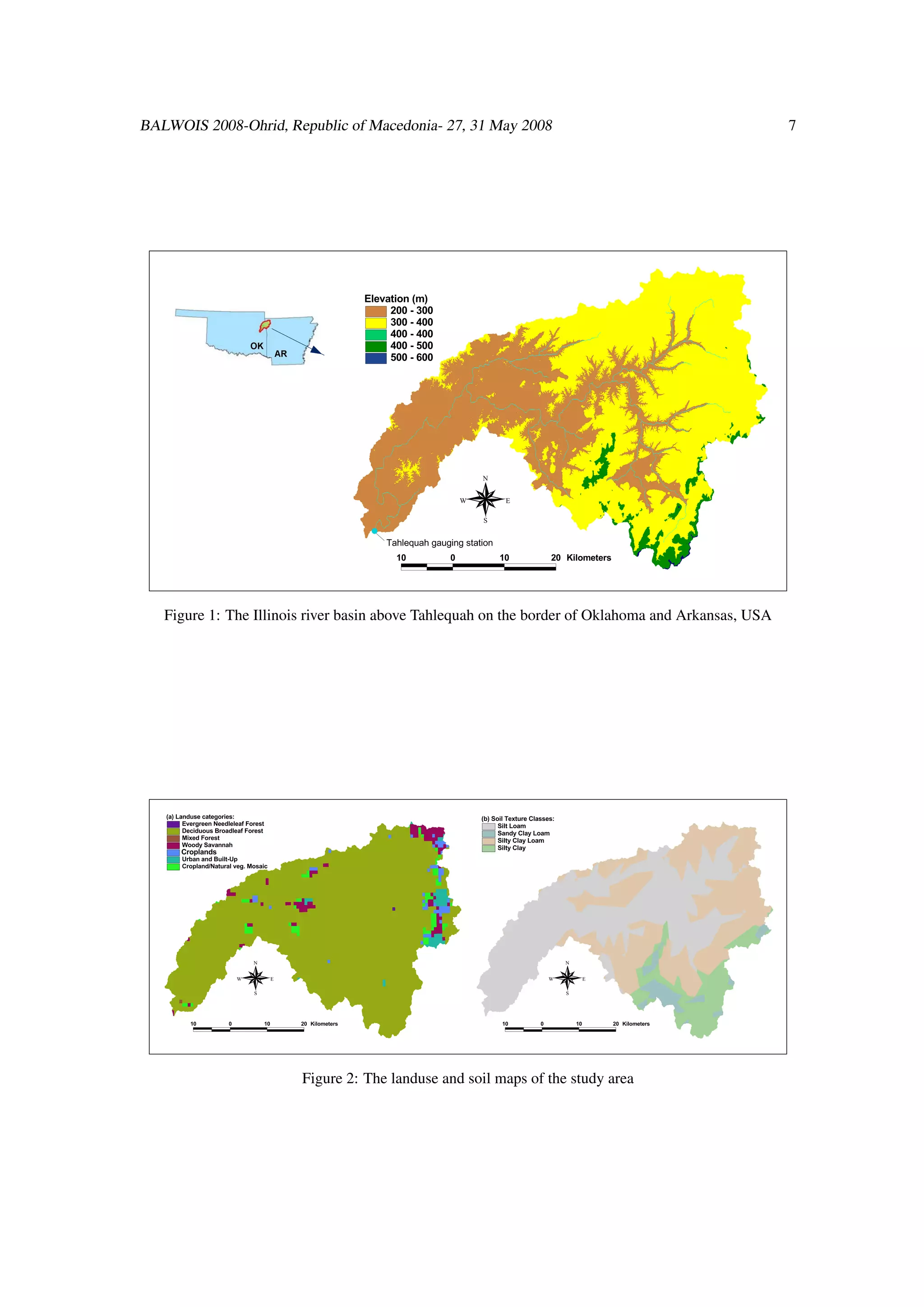
The Illinois river is located in eastern Oklahoma and western Arkansas. Streamflow data from Tahlequah
gauging station are used in this study. Figure 1 shows the location of this station and the corresponding
basin boundaries. The basin area is 2454 km2 . The average maximum and minimum air temperature in
the region are approximately 22 and 9◦C, respectively. Summer maximum temperatures can get as high as
38◦C. The annual average precipitation is 1200 mm, and the annual average potential evaporation is 1050
mm.
The topographic data was obtained from the DMIP web site in raster form with a resolution of 30 m. The
topography is gently rolling to hilly and the elevation ranges from 210 m to 600 m (Figure 1).
Landuse and soil types information are important inputs to the WetSpa model, as these influence hydrolog-
ical processes like evapotranspiration, interception, infiltration, runoff, etc. Soil types were derived from
Pennsylvania State University STATSGO data [Soil Survey Staff, 1994a, Soil Survey Staff, 1994b] and
landuse from satellite images processed through the NASA Land Data Assimilation Systems (LDAS) pro-
gram with an International Geosphere-Biosphere Program (IGBP) classification system [Eidenshink and
Faundeen, 1994]. The spatial resolution of the soil types and landuse maps is 1 km. Figure 2 shows the
land use and soil maps of the study area.
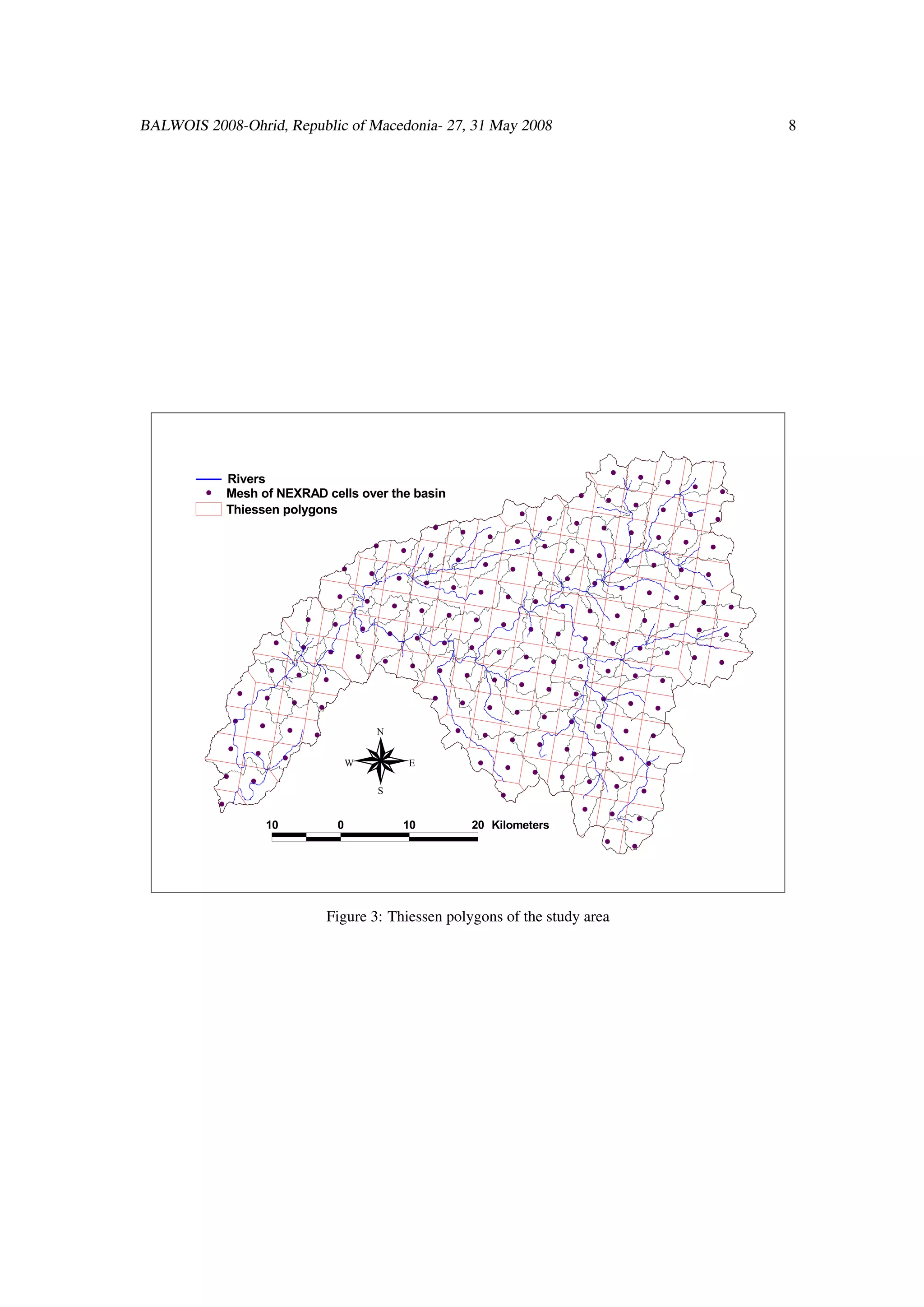
Hourly radar-based rainfall data was acquired from the DMIP database. The data sets have to be untarred,
uncompressed, transformed into ASCII format, and projected into a common coordinate system. The se-
lected mesh of NEXRAD (pseudo-station network) consisting of 150 radar points is shown in Figure 3
together with associated Thiessen polygons covering the study area.](https://image.slidesharecdn.com/balwois2008-120507164456-phpapp01/75/Streamflow-simulation-using-radar-based-precipitation-applied-to-the-Illinois-River-basin-in-Oklahoma-USA-6-2048.jpg)
![BALWOIS 2008-Ohrid, Republic of Macedonia- 27, 31 May 2008 9
Table 3: WetSpa global parameters and their calibrated values
Parameter Symbol Unit calibrated value
Interflow scaling factor Ki - 4.0
Groundwater flow recession coefficient Kg d−1 0.00125
Correction factor for potential evapotranspiration Kep - 0.875
Maximum groundwater storage gmax mm 300
Surface runoff exponent Krun - 10.0
Table 4: Simulation statistics for the calibration and validation periods
Criterion Calibration period Validation period
C1 0.145 0.043
C2 0.875 0.765
C3 0.785 0.854
C4 0.745 0.738
C5 0.886 0.906
4 Results and discussion
Theoretically the parameters of the physically based WetSpa model need not to be calibrated. However,
due to uncertainty of the model input and structure, a calibration of global model parameters (Table 3)
improves the model performance. Global model parameters are time invariant and are either adjustment
coefficients or empirical constants. These parameters and their calibration with PEST have been described
in other studies [Liu and De Smedt, 2004, Liu et al., 2005, Bahremand et al., 2006, Bahremand and De
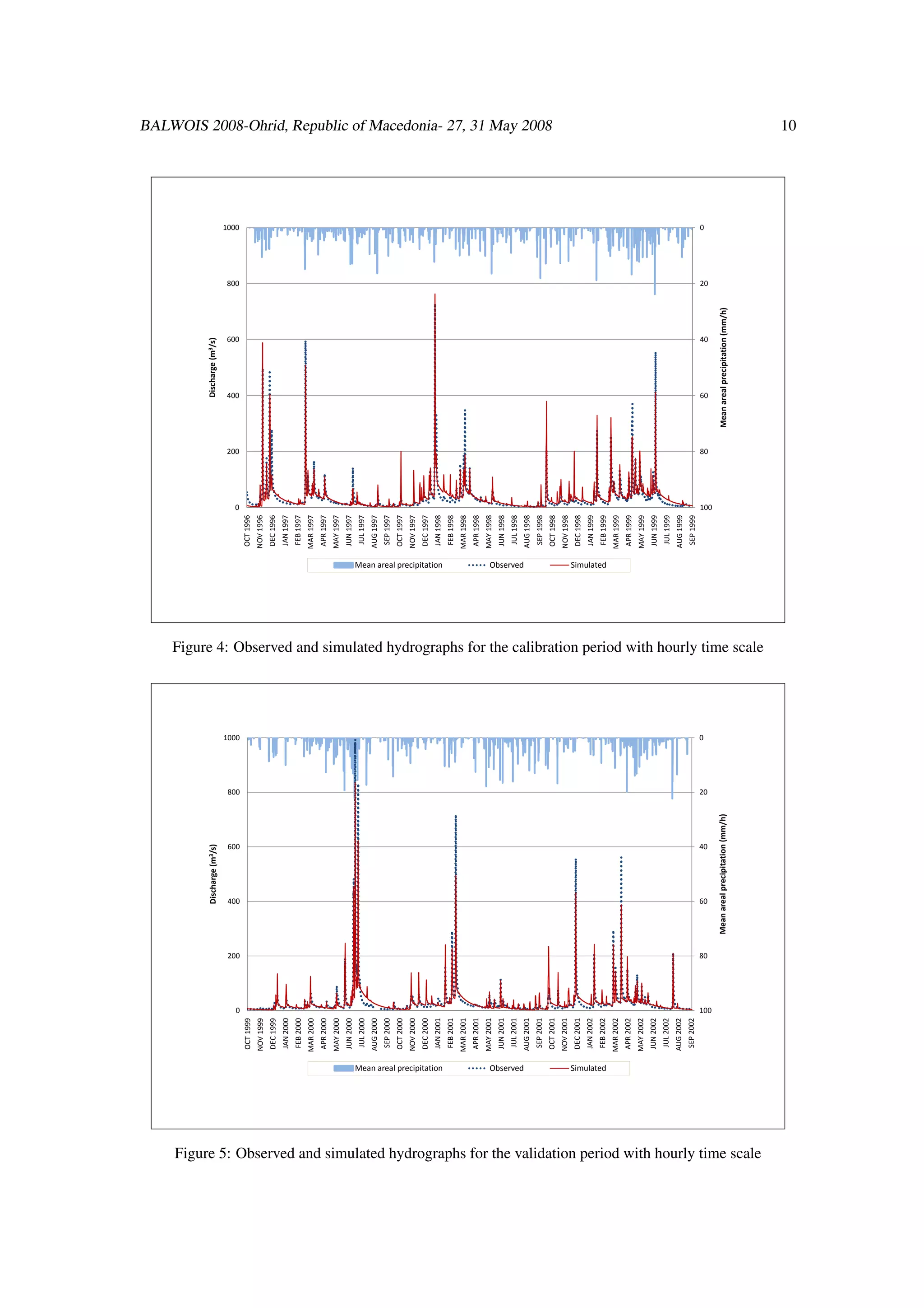
Smedt, 2007]. The historical discharge record was divided into two periods: one for calibration and one
for validation. The calibration period covers the period October 1996 to September 1999 and the validation
period the remainder until September 2002.
Figures 4 and 5 give a graphical comparison between observed and calculated hourly flows for the calibra-
tion and the validation periods, showing that the calibrated model simulates the timing and the magnitude
of the peak flows reasonably well. Table 4 presents summary statistics for the calibration and validation
periods. It is clear that the WetSpa model is performing well (Nash-Sutcliffe efficiency and modified cor-
relation index > 0.75). The results show in particular that the model is able to simulate high flows with
a very good accuracy (C5 > 0.85), while also performing well for the low base flows (C4 >0.7). The
lesser precision for low flows might be due to the simplified approach of modeling ground water storage
and drainage in WetSpa. The use of distributed and physically based predicting models could improve
base flow predictions. There is also significant uncertainty in precipitation estimates derived from weather
radar [Smith et al., 1996, Stellman et al., 2001, Carpenter and Georgakakos, 2004], which influence model
simulations significantly on all model output scales. Also, there is some uncertainty due to the inability of
the model to represent the heterogeneous nature of hydrological processes on basin scale.
5 Conclusions and recommendations
This paper presents an application of the physically based distributed hydrologic WetSpa model, forced
with radar-based precipitation data for a Distributed Model Intercomparison Project (DMIP) watershed.
Coupling to GIS makes WetSpa a powerful tool to capture local complexities of a watershed and temporal](https://image.slidesharecdn.com/balwois2008-120507164456-phpapp01/75/Streamflow-simulation-using-radar-based-precipitation-applied-to-the-Illinois-River-basin-in-Oklahoma-USA-9-2048.jpg)
![BALWOIS 2008-Ohrid, Republic of Macedonia- 27, 31 May 2008 11
variation of river flows, especially peak discharges. The model can predict not only the streamflow hydro-
graph at any controlling point of the basin, but also the spatially distributed hydrological processes, such
as surface runoff , infiltration, evapotranspiration and the like, at each time step during a simulation. All
model parameters can be obtained from DEM, land use and soil type data of the watershed or combinations
of these three fundamental maps.
Evaluation of flow simulations from WetSpa is presented in terms of summary statistics covering calibra-
tion and validation periods. The goodness of the model performance during calibration and validation
periods was evaluated and shows that the calibrated WetSpa reproduces water balance and especially high
streamflows accurately, while this is somewhat less for low flows, due to the simplified model description
of ground water flow processes. Hence, the model performance is satisfactory for both calibration and
validation periods. The model’s ability to reproduce observed hydrographs for the validation period shows
that the model can be used for prediction purposes, in particular for storm events that lead to flooding.
A potential future research is to validate the model in watersheds where snow accumulation and abla-
tion is significant (e.g. DMIP California Sierra Nevada watersheds). For these cases and especially in
mountainous terrain, uncertainty in estimated distributed precipitation is high as weather radar data can be
significantly biased (e.g. partial beam filling, ground clutter, etc.).
References
[Ajami et al., 2004] Ajami, N. K., Gupta, H., Wagener, T., and Sorooshian, S. (2004). Calibration of a
semi-distributed hydrologic model for streamflow estimation along a river system. Journal of Hydrology,
298:112–135.
[Al-Abed and Whiteley, 2002] Al-Abed, N. A. and Whiteley, H. R. (2002). Calibration of the Hydrolog-
ical Simulation Program Fortran (HSPF) model using automatic calibration and geographical informa-
tion systems. Hydrological Processes, 16:3169–3188.
[Andersen et al., 2002] Andersen, J., Dybkjaer, G., Jensen, K. H., Refsgaard, J. C., and Rasmussen, K.
(2002). Use of remotely sensed precipitation and leaf area index in a distributed hydrological model.
Journal of Hydrology, 264:34–50.
[Andersen et al., 2001] Andersen, J., Refsgaard, J., and K.H.Jensen (2001). Distributed hydrological mod-
elling of the senegal river basin–model construction and validation. Journal of Hydrology, 247:200–214.
[Baginska et al., 2003] Baginska, B., Milne-Home, W., and Cornish, P. (2003). Modelling nutrient trans-
port in Currency Creek, NSW with AnnAGNPS and PEST. Environmental Modelling & Software,
18:801–808.
[Bahremand and De Smedt, 2006] Bahremand, A. and De Smedt, F. (2006). Sensitivity and uncertainty
analysis of a GIS-based flood simulation model using PEST. Journal of WSEAS Transaction on Envi-
ronment and Development, 2(1):29–37.
[Bahremand and De Smedt, 2007] Bahremand, A. and De Smedt, F. (April , 2007). Distributed Hydro-
logical Modeling and Sensitivity Analysis in Torysa Watershed, Slovakia . Journal of Water Resources
Management, Published Online.](https://image.slidesharecdn.com/balwois2008-120507164456-phpapp01/75/Streamflow-simulation-using-radar-based-precipitation-applied-to-the-Illinois-River-basin-in-Oklahoma-USA-11-2048.jpg)
![BALWOIS 2008-Ohrid, Republic of Macedonia- 27, 31 May 2008 12
[Bahremand et al., 2006] Bahremand, A., De Smedt, F., Corluy, J., and Liu, Y. B. (2006). Application of
WetSpa model for assessing land use impacts on floods in the Margecany-Hornad watershed, Slovakia.
Journal of Water Science Technology, 53(10):37–45.
[Bandaragoda et al., 2004] Bandaragoda, C., Tarboton, D. G., and Woods, R. (2004). Application of TOP-
NET in the distributed model intercomparison project. Journal of Hydrology, 298:178–201.
[Beven, 2001] Beven, J. K., editor (2001). Rainfall-Runoff Modelling –The Primer. John Wiley & Sons
Ltd., Chichester.
[Beven and Germann, 1982] Beven, K. and Germann, P. (1982). Macropores and Water Flow in Soils.
Water Resources Research, 18, No 5:1311–1325.
[Butts et al., 2005] Butts, M., Overgaard, J., Viaene, P., Dubicki, A., Stronska, K., Szalinska, W.,
Lewandowski, A., Olszewski, T., and Kolerski, T. (2005). Flexible process-based hydrological mod-
elling framework for flood forecasting–MIKE SHE. In Proc. International conference on Innovation,
advances and implementation of flood forecasting technology, Troms, Norway.
[Carpenter and Georgakakos, 2004] Carpenter, T. M. and Georgakakos, K. P. (2004). Continuous stream-
flow simulation with the HRCDHM distributed hydrologic model. Journal of Hydrology, 298:61–79.
[Ciach et al., 1997] Ciach, G., Krajewski, W., Anagnostou, E., Baeck, M., Smith, J., McCollum, J., and
Kruger, A. (1997). Radar Rainfall Estimation for Ground Validation Studies of the Tropical Rainfall
Measuring Mission. Journal of Applied Meteorology, 36:735–747.
[De Smedt et al., 2000] De Smedt, F., Liu, Y., and Gebremeskel, S. (2000). Hydrological Modeling on a
watershed scale using GIS and remote sensed land use information. In C.A. Brebbia (ed), WTI press,
Boston.
[Doherty and Johnston, 2003] Doherty, J. and Johnston, J. M. (2003). Methodologies for calibration and
predictive analysis of a watershed model. Journal of the American Water Resources Association, Volume
39 Issue 2:251–265.
[Eagleson, 1978] Eagleson, P. (1978). Climate, soil, and vegetation, a simplified model of soil moisture
movement in liquid phase. Journal of Water Resources Research, 14 (5):722–730.
[Eidenshink and Faundeen, 1994] Eidenshink, J. and Faundeen, J. (1994). The 1-Km AVHRR global land
data set: first stages in implementation. International Journal of Remote Sensing, 15:3443–3462.
[Famiglietti and Wood, 1994] Famiglietti, J. and Wood, E. (1994). Multiscale modelling of spatially vari-
able water and energy balance processes. Water Resources Research, 30(11):3061–3078.
[Goegebeur and Pauwels, 2007] Goegebeur, M. and Pauwels, V. R. (2007). Improvement of the PEST
parameter estimation algorithm through Extended Kalman Filtering. Journal of Hydrology, 337:436–
451.
[Grecu and Krajewski, 2000] Grecu, M. and Krajewski, W. (2000). A large-sample investigation of statis-
tical procedures for radar-based short-term quantitative precipitation forecasting. Journal of Hydrology,
239:69–84.](https://image.slidesharecdn.com/balwois2008-120507164456-phpapp01/75/Streamflow-simulation-using-radar-based-precipitation-applied-to-the-Illinois-River-basin-in-Oklahoma-USA-12-2048.jpg)
![BALWOIS 2008-Ohrid, Republic of Macedonia- 27, 31 May 2008 13
[Henriksen et al., 2003] Henriksen, H. J., Troldborg, L., Nyegaard, P., Sonnenborg, T. O., Refsgaard, J. C.,
and Madsen, B. (2003). Methodology for construction, calibration and validation of a national hydro-
logical model for Denmark. Journal of Hydrology, 280:52–71.
[Hillel, 1980] Hillel, D. (1980). Application of Soil Physics. Academic Press, New York.
[Ivanov et al., 2004] Ivanov, V. Y., Vivoni, E. R., Bras, R. L., and Entekhabi, D. (2004). Preserving high-
resolution surface and rainfall data in operational-scale basin hydrology: a fully-distributed physically-
based approach. Journal of Hydrology, 298:80–111.
[Johnson et al., 1999] Johnson, D., Smith, M., Koren, V., and Finnerty, B. (1999). Comparing mean areal
precipitation estimates from NEXRAD and rain gauge networks. Journal of Hydrologic Engineering, 4
(2):117–124.
[Johnson et al., 1998] Johnson, J., MacKeen, P., Witt, A., Mitchell, E., G.J.Stumpf, Eilts, M., and Thomas,
K. (1998). The storm cell identification and tracking algorithm: an enhanced WSR-88D algorithm.
Journal of Weather and Forecasting, 13:263–276.
[Krajewsk and Smith, 2002] Krajewsk, W. and Smith, J. (2002). Radar hydrology: rainfall estimation.
Journal of Advances in Water Resources, 25:1387–1394.
[Liu and De Smedt, 2004] Liu, Y. and De Smedt, F. (2004). WetSpa extension, documentation and user
manual. Department of Hydrology and Hydraulic Engineering, Vrije Universiteit Brussel, Belgium.
[Liu et al., 2003] Liu, Y., Gebremeskel, S., De Smedt, F., Hoffmann, L., and Pfister, L. (2003). A diffusive
transport approach for flow routing in GIS-based flood modeling. Journal of Hydrology, 283:91–106.
[Liu et al., 2005] Liu, Y. B., Batelaan, O., De Smedt, F., Poorova, J., and Velcicka, L. (2005). Automated
calibration applied to a GIS-based flood simulation model using PEST. In van Alphen, J., van Beek, E.,
and Taal, M., editors, Floods, from Defence to Management, pages 317–326, London. Taylor-Francis
Group.
[McCuen and Snyder, 1975] McCuen, R. H. and Snyder, W. M. (December 1975). A Proposed Index for
Comparing Hydrographs. Water Resources Research, VOL. 11, NO. 6:1021–1024.
[Myrobo, 1997] Myrobo, S. (1997). Tempral and spatial scale of response area and groundwater variation
in till. Hydrologic Processes, 11:1861–1880.
[Nash and Sutcliffe, 1970] Nash, J. and Sutcliffe, J. (1970). River flow forecasting through conceptual
models, part 1. a discussion of principles. Journal of Hydrology, 10:282–290.
[Nossent and Bauwens, 2007] Nossent, J. and Bauwens, W. (2007). Comparing SWAT and WetSpa on
the River Grote Laak, Belgium. In The 4th International SWAT Conference, Delft, The Netherlands.
UNESCO-IHE.
[Office of Hydrologic Development, 2006] Office of Hydrologic Development, N. (2006). About the Mul-
tisensor (NEXRAD and gauge) data. Technical report, National Oceanic and Atmospheric Administra-
tion (NOAA), National Weather Service (NWS).](https://image.slidesharecdn.com/balwois2008-120507164456-phpapp01/75/Streamflow-simulation-using-radar-based-precipitation-applied-to-the-Illinois-River-basin-in-Oklahoma-USA-13-2048.jpg)
![BALWOIS 2008-Ohrid, Republic of Macedonia- 27, 31 May 2008 14
[R.A.Fulton et al., 1998] R.A.Fulton, Breidenbach, J., Seo, D., Miller, D., and OBannon, T. (1998). The
WSR-88D rainfall algorithm. Journal of Weather and Forecasting, 13:377–395.
[Reed et al., 2004] Reed, S., Koren, V., Smith, M. B., Zhang, Z., Moreda, F., Seo, D.-J., and DMIP Par-
ticipants (2004). Overall distributed model intercomparison project results. Journal of Hydrology,
298:27–60.
[Reed and Maidment, 1995] Reed, S. and Maidment, D. (1995). A GIS procedure for merging NEXRAD
precipitation data and digital elevation models to determine rainfall-runoff modeling parameters. Online
Report 95-3, Center for Research in Water Resources (CRWR), University of Texas at Austin.
[Reed and Maidment, 1999] Reed, S. and Maidment, D. (1999). Coordinate transformations for using
NEXRAD data in GIS-based hydrologic modeling. Journal of Hydrologic Engineering, 4:174–182.
[Reed et al., 2007] Reed, S., Schaake, J., and Zhang, Z. (2007). A distributed hydrologic model and thresh-
old frequency-based method for flash flood forecasting at ungauged locations. Journal of Hydrology,
337:402– 420.
[Seo et al., 1999] Seo, D., Breidenbach, J., and Johnson, E. (1999). Real-time estimation of mean field
bias in radar rainfall data. Journal of Hydrology, 223:131–147.
[Smith et al., 2005] Smith, J. A., Miller, A. J., Baeck, M. L., Nelson, P. A., Fisher, G. T., and Meierdiercks,
K. L. (2005). Extraordinary Flood Response of a Small Urban Watershed to Short-Duration Convective
Rainfall. Journal of Hydrometeorology, 6:599–617.
[Smith et al., 1996] Smith, J. A., Seo, D. J., Baeck, M. L., and Hudlow, M. D. (1996). An intercomparison
study of NEXRAD precipitation estimates. Water Resources Research, 32:2035–2046.
[Smith, 2002] Smith, M. B. (2002). Distributed model intercomparison project (DMIP). from the World
Wide Web: http://www.nws.noaa.gov/oh/hrl/dmip/.
[Smith, 2004] Smith, M. B. (2004). The distributed model intercomparison project (DMIP). Journal of
Hydrology, 298:1–3.
[Smith et al., 2004] Smith, M. B., Seo, D.-J., Koren, V. I., Reed, S. M., Zhang, Z., Duan, Q., Moreda, F.,
and Cong, S. (2004). The distributed model intercomparison project (DMIP): motivation and experiment
design. Journal of Hydrology, 298:4–26.
[Soil Survey Staff, 1994a] Soil Survey Staff (1994a). State Soil Geographic Database (STATSGO) Col-
lection for the Conterminous United States. CD-ROM, USDA-NRCS, National Soil Survey Center,
Lincoln, NE.
[Soil Survey Staff, 1994b] Soil Survey Staff (1994b). State Soil Geographic Database (STATSGO) Data
Users Guide Miscellaneous Publication 1492. Technical report, USDA Natural Resources Conservation
Service, US Government Printing Office, Washington.
[Stellman et al., 2001] Stellman, K., Fuelberg, H., Garza, R., and Mullusky, M. (2001). An examination
of radar and rain gauge–derived mean areal precipitation over georgia watersheds. Weather and Fore-
casting, 16:133–144.](https://image.slidesharecdn.com/balwois2008-120507164456-phpapp01/75/Streamflow-simulation-using-radar-based-precipitation-applied-to-the-Illinois-River-basin-in-Oklahoma-USA-14-2048.jpg)
![BALWOIS 2008-Ohrid, Republic of Macedonia- 27, 31 May 2008 15
[Thornthwaite and Mather, 1955] Thornthwaite, C. and Mather, J. (1955). The water balance. Technical
Report Publ. No. 8, Laboratory of Climatology, Centerton NJ.
[Uijlenhoet et al., 2003] Uijlenhoet, R., Steiner, M., and Smith, J. (2003). Variability of Raindrop Size
Distributions in a Squall Line and Implications for Radar Rainfall Estimation. Journal of Hydrometeo-
rology, 4:43–61.
[Wang and Melesse, 2005] Wang, X. and Melesse, A. M. (2005). Evaluation of the SWAT model’s
snowmelt hydrology in a northwestern Minnesota watershed. Journal of American Society of Agri-
cultural and Biological Engineers, 48(4):1359–1376.
[Wang et al., 1997] Wang, Z., Batellan, O., and De Smedt, F. (1997). A distributed model for Water and
Energy Transfer between Soil, Plants and Atmosphere (WetSpa). Journal of Physics and Chemistry of
the Earth, 21:189–193.
[Young et al., 2000] Young, C., Bradley, A. A., Krajewski, W., Kruger, A., and Morrissey, M. (2000).
Evaluating NEXRAD multisensor precipitation estimates for operational hydrologic forecasting. Jour-
nal of Hydrometeorology, 1:241–254.
[Zeinivand et al., 2007] Zeinivand, H., De Smedt, F., and Bahremand, A. (2007). Simulation of basin
runoff due to rainfall and snowmelt. In MODSIM 2007 International Congress on Modelling and
Simulation. Modelling and Simulation Society of Australia and New Zealand, pages 1796–1802,
Christchurch, New Zealand.
[Zyvoloski et al., 2003] Zyvoloski, G., Kwicklis, E., Eddebbarh, A. A., Arnold, B., Faunt, C., and Robin-
son, B. A. (2003). The site-scale saturated zone flow model for Yucca Mountain: calibration of different
conceptual models and their impact on flow paths. Journal of Contaminant Hydrology, 62–63:731–750.](https://image.slidesharecdn.com/balwois2008-120507164456-phpapp01/75/Streamflow-simulation-using-radar-based-precipitation-applied-to-the-Illinois-River-basin-in-Oklahoma-USA-15-2048.jpg)

The paper presents a study using the WetSpa hydrological model to simulate streamflow in the Illinois River Basin using radar-based precipitation data from NOAA. The model was calibrated using local watershed characteristics and demonstrated good accuracy in simulating streamflow, thereby highlighting the effectiveness of radar data for hydrological modeling. The research is part of the Distributed Model Intercomparison Project (DMIP), aimed at enhancing flood prediction through the integration of spatially distributed hydrological models.