Download as PDF, PPTX

![CHECKLIST FOR CP-39 WETLAND
Location: County:
Task Method for Completion Completed: Y/N
Sign CRP-2 worksheet Landowner must go to local FSA office
to coordinate signing of CRP-2.
Completed
Wetland Design Engineer is notified that landowner is
interested in a wetland and proceeds with
developing a wetland design.
Completed
Conservation Plan of
Operation (CPO)
NRCS will develop a Conservation Plan
of Operation and Detailed Map
explaining wetland pool/buffer location
and costs for wetland construction.
[Note: If canceling part of an existing
CRP contract (CP21 grass filter strip),
NRCS also makes any necessary
amendments to CPO and revises map of
remaining CP21 grass filter strip acres.]
Completed
Review of CPO, Detailed
Map, and Design
Landowner will be asked by local
NRCS/SWCD personnel to review CPO,
Detailed Map, and Wetland Design.
Completed
Sign CRP-1 Contract Landowner must go to local FSA office
to coordinate signing of CRP-1 contract.
Completed
Signing Incentive Payment
(SIP)
Once FSA County Committee (COC)
approves CRP-1, CPO and supporting
documents, FSA can issue the SIP
payment (currently $100/acre).
Completed
Implementation of CP-39
contract agreement
Landowner implements CP-39 contract
agreement including all seeding.
Seeding dates for late summer are
August 1 – September 10 and spring
period is Early Spring – May 15.
Completed](https://image.slidesharecdn.com/strategicwatershedscaleoutreach-140808105223-phpapp01/85/Strategic-watershed-scale-outreach-20-320.jpg)

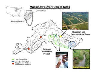
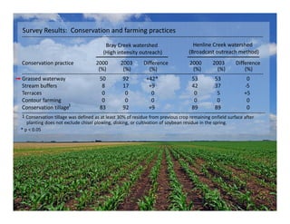
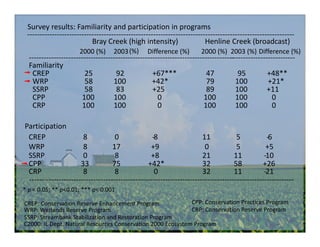
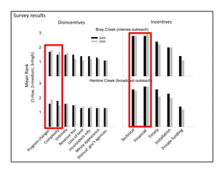
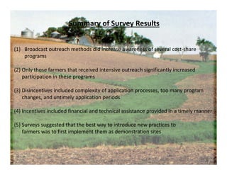
The document discusses the outreach efforts and their effectiveness in promoting conservation practices among farmers in the Mackinaw River watershed, Illinois. It highlights the comparison between high-intensity and broadcast outreach methods and their impact on awareness and participation in cost-share programs. Results indicate that intensive outreach significantly increased farmers' familiarity and effective practices, while also identifying key disincentives and incentives influencing participation.