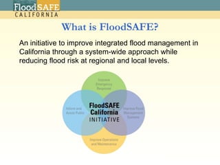
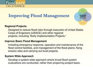
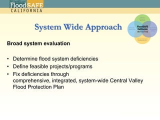
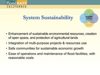
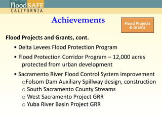
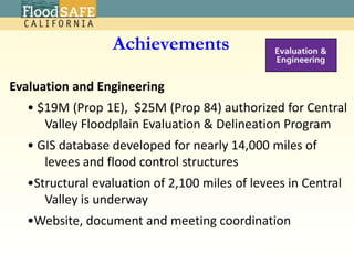
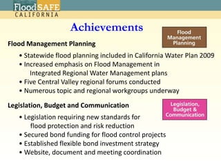
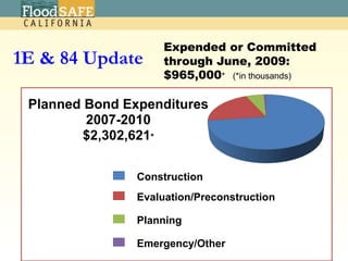
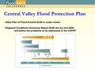
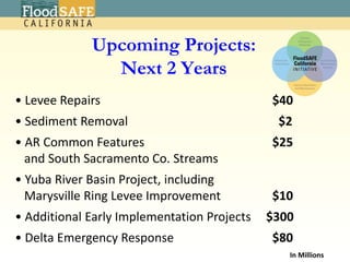
FloodSAFE CaliforniaSAME 2009 California Water ConferenceOctober 28, 2009Mark CowinDeputy Director, California Department of Water Resources2
What is FloodSAFE?An initiative to improve integrated flood management in California through a system-wide approach while reducing flood risk at regional and local levels.
Improving Flood ManagementRegional Projects	Designed to reduce flood risks through execution of United States Corps of Engineers (USACE) and other regional projects, including “Early Implementation Projects.” Improve Basic Flood Management Including emergency response, operation and maintenance of the flood control facilities, and management of the flood plains; fixing  erosion sites and carrying out local projects.System Wide Approach Develop a system-wide approach where broad flood system evaluations are conducted, rather than project-by-project basis.4
System Wide ApproachBroad system evaluation Determine flood system deficiencies Define feasible projects/programs Fix deficiencies through comprehensive, integrated, system-wide Central Valley Flood Protection Plan4
System SustainabilityEnhancement of sustainable environmental resources, creation of open space, and protection of agricultural lands
Integration of multi-purpose projects & resources use
Safe communities for sustainable economic growth
Ease of operations and maintenance of flood facilities, with reasonable costs2
FloodSAFE InitiativeFunctional Areas
FloodSAFE Initiative Functional Areas /USACE National Flood Risk Management Program
USACE – DWR PartnershipCost SharedCentral Valley Integrated Flood Management PlanSacramento River Flood Control System EvaluationCapital Construction Projects:Folsom Dam ModificationsFolsom Dam RaiseAmerican River Common FeaturesSouth Sacramento StreamsMid-Valley Area Levee ReconstructionMarysville Ring LeveeCalFed Levee StabilitySacramento River Bank ProtectionGeneral Reevaluation Reports	American River Common Features, West Sacramento, Yuba River BasinFeasibility Studies	Sutter Basin, Lower San Joaquin River, Delta Islands & Levees, 	Lower Cache Creek, West Stanislaus Delta Long-Term Management StrategyMaintenance of California Debris Commission facilities 2
USACE – DWR PartnershipDWR-Funded Programs Levee Evaluations for the Central ValleyCentral Valley Floodplain Evaluation and DelineationCentral Valley Hydrology StudySacramento & San Joaquin River Basins Hydrology Study – Climate Change Impacts Interagency Flood Management Collaborative ProgramCooperating Agency Delta Emergency PlanSystem ReoperationCoordinated Reservoir Operation, Forecast-Based Reservoir OperationsEncroachment permitting Project Modification approvals Emergency Assistance Recovery Mechanism (PL 84-99)Levee Maintenance in the State Plan of Flood Control; Vegetation Management Round TableShared vision planning for the California Water Plan 2
AchievementsEmergency Response Deployment of rock material in the Delta
 Levee inspection process and reporting modernization
 Completed San Joaquin River system erosion survey 	and mapping Enhanced capability of Incident Command Teams
 Web-cast weather/flood briefings to flood control agencies2
AchievementsOperations and Maintenance116 Critical levee repairs completed
 121 Proactive repairs completed
Removed 2.5 M cubic yards of sediment from Bypasses
 Resurfaced 50 miles of levee crown roads

Mark Cowin Same 10282009

  • 1.
    FloodSAFE CaliforniaSAME 2009California Water ConferenceOctober 28, 2009Mark CowinDeputy Director, California Department of Water Resources2
  • 2.
    What is FloodSAFE?Aninitiative to improve integrated flood management in California through a system-wide approach while reducing flood risk at regional and local levels.
  • 3.
    Improving Flood ManagementRegionalProjects Designed to reduce flood risks through execution of United States Corps of Engineers (USACE) and other regional projects, including “Early Implementation Projects.” Improve Basic Flood Management Including emergency response, operation and maintenance of the flood control facilities, and management of the flood plains; fixing erosion sites and carrying out local projects.System Wide Approach Develop a system-wide approach where broad flood system evaluations are conducted, rather than project-by-project basis.4
  • 4.
    System Wide ApproachBroadsystem evaluation Determine flood system deficiencies Define feasible projects/programs Fix deficiencies through comprehensive, integrated, system-wide Central Valley Flood Protection Plan4
  • 5.
    System SustainabilityEnhancement ofsustainable environmental resources, creation of open space, and protection of agricultural lands
  • 6.
    Integration of multi-purposeprojects & resources use
  • 7.
    Safe communities forsustainable economic growth
  • 8.
    Ease of operationsand maintenance of flood facilities, with reasonable costs2
  • 9.
  • 10.
    FloodSAFE Initiative FunctionalAreas /USACE National Flood Risk Management Program
  • 11.
    USACE – DWRPartnershipCost SharedCentral Valley Integrated Flood Management PlanSacramento River Flood Control System EvaluationCapital Construction Projects:Folsom Dam ModificationsFolsom Dam RaiseAmerican River Common FeaturesSouth Sacramento StreamsMid-Valley Area Levee ReconstructionMarysville Ring LeveeCalFed Levee StabilitySacramento River Bank ProtectionGeneral Reevaluation Reports American River Common Features, West Sacramento, Yuba River BasinFeasibility Studies Sutter Basin, Lower San Joaquin River, Delta Islands & Levees, Lower Cache Creek, West Stanislaus Delta Long-Term Management StrategyMaintenance of California Debris Commission facilities 2
  • 12.
    USACE – DWRPartnershipDWR-Funded Programs Levee Evaluations for the Central ValleyCentral Valley Floodplain Evaluation and DelineationCentral Valley Hydrology StudySacramento & San Joaquin River Basins Hydrology Study – Climate Change Impacts Interagency Flood Management Collaborative ProgramCooperating Agency Delta Emergency PlanSystem ReoperationCoordinated Reservoir Operation, Forecast-Based Reservoir OperationsEncroachment permitting Project Modification approvals Emergency Assistance Recovery Mechanism (PL 84-99)Levee Maintenance in the State Plan of Flood Control; Vegetation Management Round TableShared vision planning for the California Water Plan 2
  • 13.
    AchievementsEmergency Response Deploymentof rock material in the Delta
  • 14.
    Levee inspectionprocess and reporting modernization
  • 15.
    Completed SanJoaquin River system erosion survey and mapping Enhanced capability of Incident Command Teams
  • 16.
    Web-cast weather/floodbriefings to flood control agencies2
  • 17.
    AchievementsOperations and Maintenance116Critical levee repairs completed
  • 18.
    121 Proactiverepairs completed
  • 19.
    Removed 2.5 Mcubic yards of sediment from Bypasses
  • 20.
    Resurfaced 50miles of levee crown roads