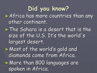
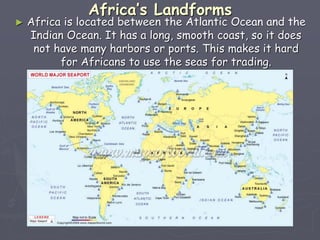
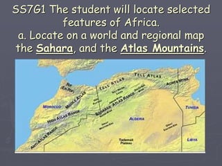
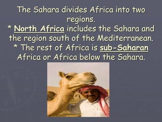
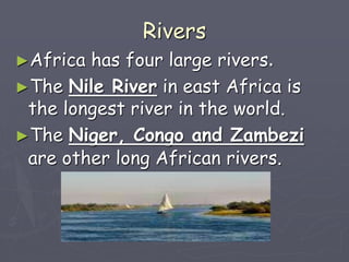
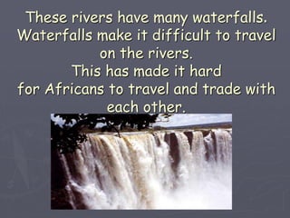
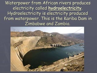
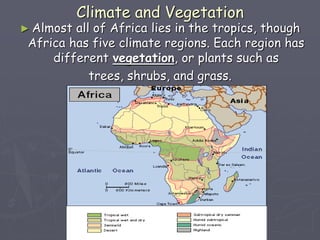
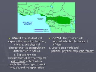
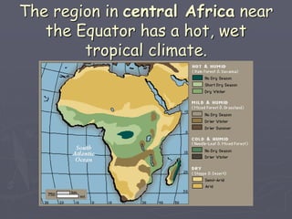
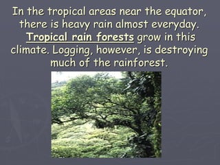
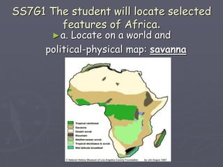
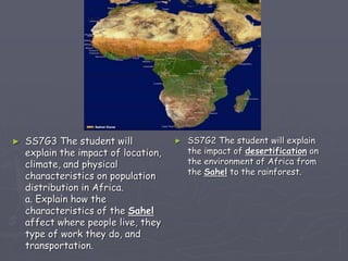
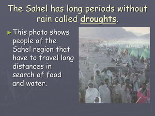
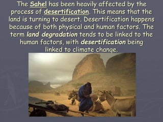
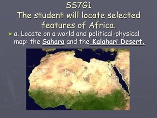
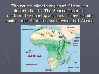
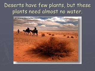
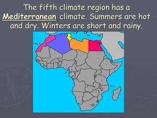
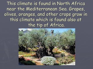
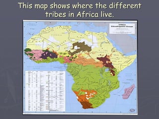
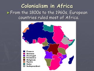
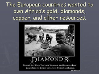
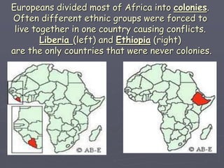
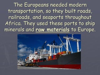
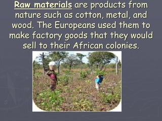
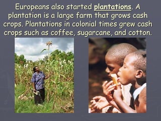
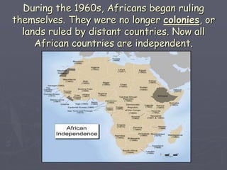
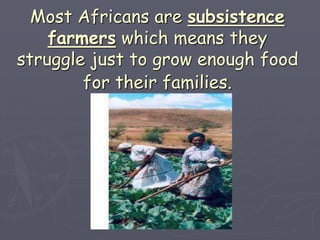
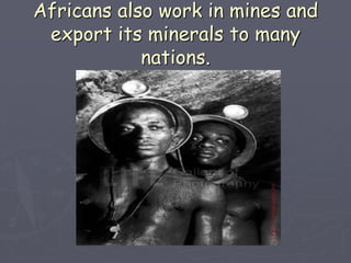
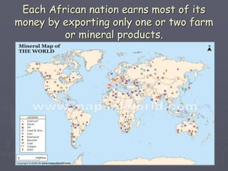
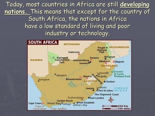
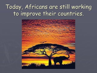
Introduction to
Africa
Did you know?
►Africa has more countries than any
other continent.
►The Sahara is a desert that is the
size of the U.S. It’s the world's
largest desert.
►Most of the world’s gold and
diamonds come from Africa.
►More than 800 languages are
spoken in Africa.
Africa’s Landforms
► Africa is located between the Atlantic Ocean and the
Indian Ocean. It has a long, smooth coast, so it does
not have many harbors or ports. This makes it hard
for Africans to use the seas for trading.
SS7G1 The student will locate selected
features of Africa.
a. Locate on a world and regional map
the Sahara, and the Atlas Mountains.
The Sahara, which is Arabic for
desert, stretches from the
Atlantic Ocean to the Red Sea.
It’s the world’s largest desert.
Years can pass without rain.
The Sahara divides Africa into two
regions.
* North Africa includes the Sahara and
the region south of the Mediterranean.
* The rest of Africa is sub-Saharan
Africa or Africa below the Sahara.
A huge plateau covers most of Africa. This is a
broad area of high, flat land. This makes it higher
in eastern and southern Africa than in other
parts. A plateau is one of the four basic
landforms. A narrow coastal plain surrounds
the plateau in Africa. This is the
Waterburg Plateau in Namibia.
The Atlas Mountains are in northwest Africa.
There are no mountain chains south
of the Sahara, but there are some
high mountains. The highest mountain in
Africa is Mount Kilimanjaro which is on the
border of Kenya and Tanzania.
There is always snow on top.
The Great Rift Valley is an important
landform in east Africa. It is made of
deep, wide cracks in the Earth’s
surface. Many lakes are in this valley.
This is a portion of the GRV in Kenya.
SS7G1 The student will locate
selected features of Africa.
►a. Locate on a world and
political-physical map: Congo River, Niger
River, Nile River.
Rivers
►Africa has four large rivers.
►The Nile River in east Africa is
the longest river in the world.
►The Niger, Congo and Zambezi
are other long African rivers.
These rivers have many waterfalls.
Waterfalls make it difficult to travel
on the rivers.
This has made it hard
for Africans to travel and trade with
each other.
Waterpower from African rivers produces
electricity called hydroelectricity.
Hydroelectricity is electricity produced
from waterpower. This is the Kariba Dam in
Zimbabwe and Zambia.
Climate and Vegetation
► Almost all of Africa lies in the tropics, though
Africa has five climate regions. Each region has
different vegetation, or plants such as
trees, shrubs, and grass.
► SS7G3 The student will
explain the impact of location,
climate, and physical
characteristics on population
distribution in Africa.
a. Explain how the
characteristics of the tropical
rain forest affect where
people live, they type of work
they do, and transportation.
► SS7G1 The student will
located selected features of
Africa.
a. Locate on a world and
political-physical map: rain forest
The region in central Africa near
the Equator has a hot, wet
tropical climate.
In the tropical areas near the equator,
there is heavy rain almost everyday.
Tropical rain forests grow in this
climate. Logging, however, is destroying
much of the rainforest.
SS7G1 The student will locate selected
features of Africa.
►a. Locate on a world and
political-physical map: savanna
The second climate region is north and
south of the rainforests.
The climate is hot, with both rainy and
dry seasons.
Savannas cover this region. Savannas
are large land areas with long, thick
grass and short trees. Many wild
animals live on the savannas.
North and south of the savannas, the climate is
semi-arid which means that the climate is hot
with both rainy and dry seasons. There may be
only ten inches of rain during the year.
SS7G1 The student will locate
selected features of Africa.
►a. Locate on a world and regional political
and physical map: the Sahel.
The semi-arid zones of Africa are part
of the Sahel. The Sahel is a region of
dry grasslands south of the Sahara.
The word “sahel” is Arabic
for “edge of desert” or “border.”
The Sahel stretches from the Atlantic
Ocean to the Red Sea. Twelve countries
are in the Sahel.
► SS7G3 The student will
explain the impact of location,
climate, and physical
characteristics on population
distribution in Africa.
a. Explain how the
characteristics of the Sahel
affect where people live, they
type of work they do, and
transportation.
► SS7G2 The student will explain
the impact of desertification on
the environment of Africa from
the Sahel to the rainforest.
The Sahel has long periods without
rain called droughts.
►This photo shows
people of the
Sahel region that
have to travel long
distances in
search of food
and water.
The Sahel has been heavily affected by the
process of desertification. This means that the
land is turning to desert. Desertification happens
because of both physical and human factors. The
term land degradation tends to be linked to the
human factors, with desertification being
linked to climate change.
SS7G1
The student will locate selected
features of Africa.
►a. Locate on a world and political-physical
map: the Sahara and the Kalahari Desert.
The fourth climate region of Africa is a
desert climate. The Sahara Desert is
north of the short grasslands. There are also
smaller deserts at the southern end of Africa.
Deserts have few plants, but these
plants need almost no water.
The fifth climate region has a
Mediterranean climate. Summers are hot
and dry. Winters are short and rainy.
This climate is found in North Africa
near the Mediterranean Sea. Grapes,
olives, oranges, and other crops grow in
this climate which is found also at
the tip of Africa.
Africa’s History and Economy
►People have lived in Africa for thousands
of years. It is sometimes called the
“cradle of civilization.”
SS7G4 The student will explain the
diverse cultures of the people
who live in Africa.
►Hundreds of ethnic groups live together in
close groups called tribes. Each ethnic group
has its own language, religion, and culture
which can sometimes cause conflicts.
This map shows where the different
tribes in Africa live.
SS7H1 The student will analyze continuity and
change in Africa leading to the 21st century.
a. Explain how European partitioning across
Africa contributed to conflict, civil war, and
artificial political boundaries.
Colonialism in Africa
►From the 1800s to the 1960s, European
countries ruled most of Africa.
The European countries wanted to
own Africa’s gold, diamonds,
copper, and other resources.
Europeans divided most of Africa into colonies.
Often different ethnic groups were forced to
live together in one country causing conflicts.
Liberia (left) and Ethiopia (right)
are the only countries that were never colonies.
Many of these ethnic groups were enemies
and could not get along. Today fighting
among ethnic groups is still a problem.
► "We are fighting
every day because
we are Hutu and
they are Tutsis. We
cannot mix, we are
always in conflict,"
the tribesman said.
"We will stay
enemies forever."
(left, Hutu soldiers in Rwanda)
The Europeans needed modern
transportation, so they built roads,
railroads, and seaports throughout
Africa. They used these ports to ship
minerals and raw materials to Europe.
Raw materials are products from
nature such as cotton, metal, and
wood. The Europeans used them to
make factory goods that they would
sell to their African colonies.
Europeans also started plantations. A
plantation is a large farm that grows cash
crops. Plantations in colonial times grew cash
crops such as coffee, sugarcane, and cotton.
During the 1960s, Africans began ruling
themselves. They were no longer colonies, or
lands ruled by distant countries. Now all
African countries are independent.
Life Today
►Today most Africans earn a living by farming.
►They use traditional methods like using
animals to pull plows instead of modern farm
machinery like tractors.
Most Africans are subsistence
farmers which means they
struggle just to grow enough food
for their families.
Africans also work in mines and
export its minerals to many
nations.
Each African nation earns most of its
money by exporting only one or two farm
or mineral products.
Today, most countries in Africa are still developing
nations. This means that except for the country of
South Africa, the nations in Africa
have a low standard of living and poor
industry or technology.
Today, Africans are still working
to improve their countries.

SS7G1 - Africa Geography.ppt

  • 1.
  • 2.
    Did you know? ►Africahas more countries than any other continent. ►The Sahara is a desert that is the size of the U.S. It’s the world's largest desert. ►Most of the world’s gold and diamonds come from Africa. ►More than 800 languages are spoken in Africa.
  • 3.
    Africa’s Landforms ► Africais located between the Atlantic Ocean and the Indian Ocean. It has a long, smooth coast, so it does not have many harbors or ports. This makes it hard for Africans to use the seas for trading.
  • 4.
    SS7G1 The studentwill locate selected features of Africa. a. Locate on a world and regional map the Sahara, and the Atlas Mountains.
  • 5.
    The Sahara, whichis Arabic for desert, stretches from the Atlantic Ocean to the Red Sea. It’s the world’s largest desert. Years can pass without rain.
  • 6.
    The Sahara dividesAfrica into two regions. * North Africa includes the Sahara and the region south of the Mediterranean. * The rest of Africa is sub-Saharan Africa or Africa below the Sahara.
  • 7.
    A huge plateaucovers most of Africa. This is a broad area of high, flat land. This makes it higher in eastern and southern Africa than in other parts. A plateau is one of the four basic landforms. A narrow coastal plain surrounds the plateau in Africa. This is the Waterburg Plateau in Namibia.
  • 8.
    The Atlas Mountainsare in northwest Africa. There are no mountain chains south of the Sahara, but there are some high mountains. The highest mountain in Africa is Mount Kilimanjaro which is on the border of Kenya and Tanzania. There is always snow on top.
  • 9.
    The Great RiftValley is an important landform in east Africa. It is made of deep, wide cracks in the Earth’s surface. Many lakes are in this valley. This is a portion of the GRV in Kenya.
  • 10.
    SS7G1 The studentwill locate selected features of Africa. ►a. Locate on a world and political-physical map: Congo River, Niger River, Nile River.
  • 11.
    Rivers ►Africa has fourlarge rivers. ►The Nile River in east Africa is the longest river in the world. ►The Niger, Congo and Zambezi are other long African rivers.
  • 12.
    These rivers havemany waterfalls. Waterfalls make it difficult to travel on the rivers. This has made it hard for Africans to travel and trade with each other.
  • 13.
    Waterpower from Africanrivers produces electricity called hydroelectricity. Hydroelectricity is electricity produced from waterpower. This is the Kariba Dam in Zimbabwe and Zambia.
  • 14.
    Climate and Vegetation ►Almost all of Africa lies in the tropics, though Africa has five climate regions. Each region has different vegetation, or plants such as trees, shrubs, and grass.
  • 15.
    ► SS7G3 Thestudent will explain the impact of location, climate, and physical characteristics on population distribution in Africa. a. Explain how the characteristics of the tropical rain forest affect where people live, they type of work they do, and transportation. ► SS7G1 The student will located selected features of Africa. a. Locate on a world and political-physical map: rain forest
  • 16.
    The region incentral Africa near the Equator has a hot, wet tropical climate.
  • 17.
    In the tropicalareas near the equator, there is heavy rain almost everyday. Tropical rain forests grow in this climate. Logging, however, is destroying much of the rainforest.
  • 18.
    SS7G1 The studentwill locate selected features of Africa. ►a. Locate on a world and political-physical map: savanna
  • 19.
    The second climateregion is north and south of the rainforests. The climate is hot, with both rainy and dry seasons.
  • 20.
    Savannas cover thisregion. Savannas are large land areas with long, thick grass and short trees. Many wild animals live on the savannas.
  • 21.
    North and southof the savannas, the climate is semi-arid which means that the climate is hot with both rainy and dry seasons. There may be only ten inches of rain during the year.
  • 22.
    SS7G1 The studentwill locate selected features of Africa. ►a. Locate on a world and regional political and physical map: the Sahel.
  • 23.
    The semi-arid zonesof Africa are part of the Sahel. The Sahel is a region of dry grasslands south of the Sahara. The word “sahel” is Arabic for “edge of desert” or “border.”
  • 24.
    The Sahel stretchesfrom the Atlantic Ocean to the Red Sea. Twelve countries are in the Sahel.
  • 25.
    ► SS7G3 Thestudent will explain the impact of location, climate, and physical characteristics on population distribution in Africa. a. Explain how the characteristics of the Sahel affect where people live, they type of work they do, and transportation. ► SS7G2 The student will explain the impact of desertification on the environment of Africa from the Sahel to the rainforest.
  • 26.
    The Sahel haslong periods without rain called droughts. ►This photo shows people of the Sahel region that have to travel long distances in search of food and water.
  • 27.
    The Sahel hasbeen heavily affected by the process of desertification. This means that the land is turning to desert. Desertification happens because of both physical and human factors. The term land degradation tends to be linked to the human factors, with desertification being linked to climate change.
  • 28.
    SS7G1 The student willlocate selected features of Africa. ►a. Locate on a world and political-physical map: the Sahara and the Kalahari Desert.
  • 29.
    The fourth climateregion of Africa is a desert climate. The Sahara Desert is north of the short grasslands. There are also smaller deserts at the southern end of Africa.
  • 30.
    Deserts have fewplants, but these plants need almost no water.
  • 31.
    The fifth climateregion has a Mediterranean climate. Summers are hot and dry. Winters are short and rainy.
  • 32.
    This climate isfound in North Africa near the Mediterranean Sea. Grapes, olives, oranges, and other crops grow in this climate which is found also at the tip of Africa.
  • 33.
    Africa’s History andEconomy ►People have lived in Africa for thousands of years. It is sometimes called the “cradle of civilization.”
  • 34.
    SS7G4 The studentwill explain the diverse cultures of the people who live in Africa.
  • 35.
    ►Hundreds of ethnicgroups live together in close groups called tribes. Each ethnic group has its own language, religion, and culture which can sometimes cause conflicts.
  • 36.
    This map showswhere the different tribes in Africa live.
  • 37.
    SS7H1 The studentwill analyze continuity and change in Africa leading to the 21st century. a. Explain how European partitioning across Africa contributed to conflict, civil war, and artificial political boundaries.
  • 38.
    Colonialism in Africa ►Fromthe 1800s to the 1960s, European countries ruled most of Africa.
  • 39.
    The European countrieswanted to own Africa’s gold, diamonds, copper, and other resources.
  • 40.
    Europeans divided mostof Africa into colonies. Often different ethnic groups were forced to live together in one country causing conflicts. Liberia (left) and Ethiopia (right) are the only countries that were never colonies.
  • 41.
    Many of theseethnic groups were enemies and could not get along. Today fighting among ethnic groups is still a problem. ► "We are fighting every day because we are Hutu and they are Tutsis. We cannot mix, we are always in conflict," the tribesman said. "We will stay enemies forever." (left, Hutu soldiers in Rwanda)
  • 42.
    The Europeans neededmodern transportation, so they built roads, railroads, and seaports throughout Africa. They used these ports to ship minerals and raw materials to Europe.
  • 43.
    Raw materials areproducts from nature such as cotton, metal, and wood. The Europeans used them to make factory goods that they would sell to their African colonies.
  • 44.
    Europeans also startedplantations. A plantation is a large farm that grows cash crops. Plantations in colonial times grew cash crops such as coffee, sugarcane, and cotton.
  • 45.
    During the 1960s,Africans began ruling themselves. They were no longer colonies, or lands ruled by distant countries. Now all African countries are independent.
  • 46.
    Life Today ►Today mostAfricans earn a living by farming. ►They use traditional methods like using animals to pull plows instead of modern farm machinery like tractors.
  • 47.
    Most Africans aresubsistence farmers which means they struggle just to grow enough food for their families.
  • 48.
    Africans also workin mines and export its minerals to many nations.
  • 49.
    Each African nationearns most of its money by exporting only one or two farm or mineral products.
  • 50.
    Today, most countriesin Africa are still developing nations. This means that except for the country of South Africa, the nations in Africa have a low standard of living and poor industry or technology.
  • 51.
    Today, Africans arestill working to improve their countries.