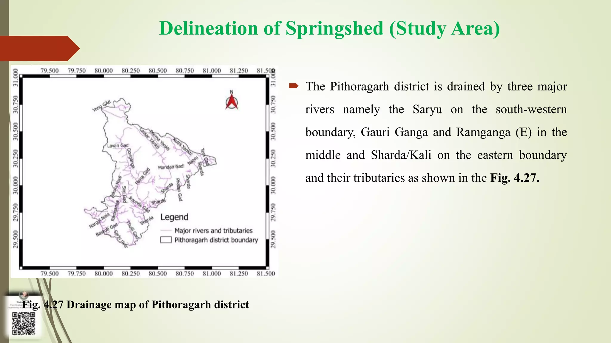
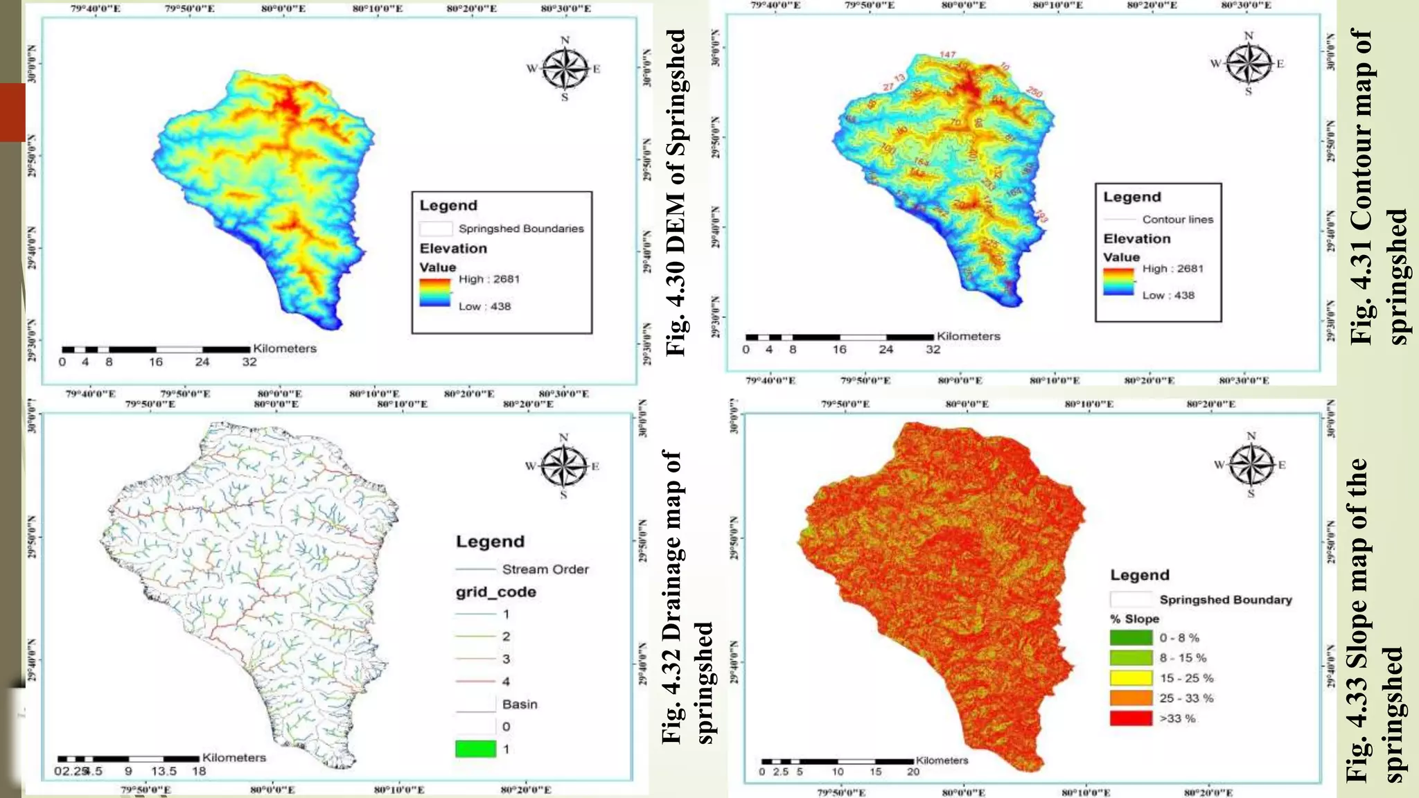
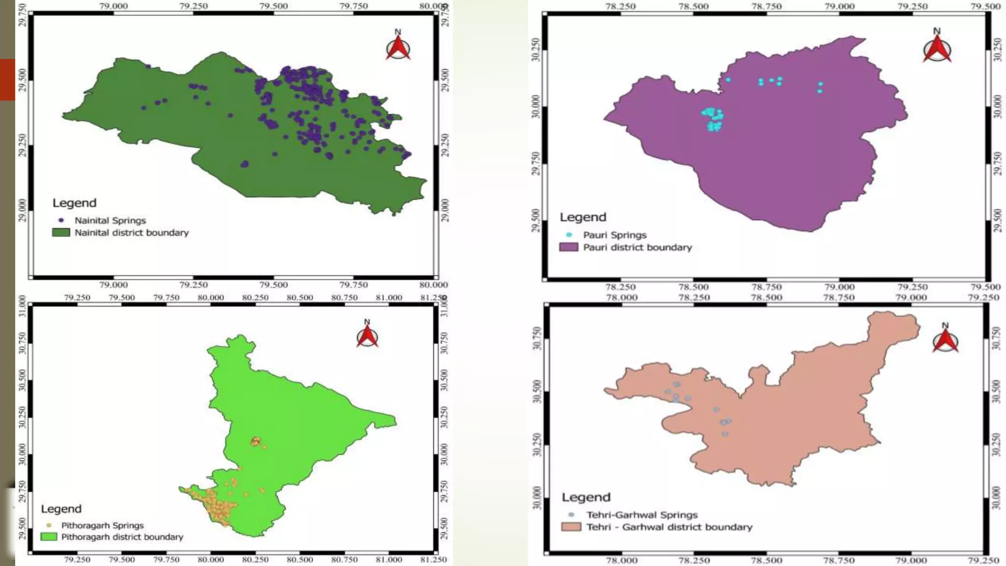
Study on Current Status, Geology and Restoration Plan for
Natural Springs in Hilly Region of Uttarakhand
Department of Irrigation and Drainage Engineering
Under the supervision of
Dr. Vinod Kumar
(Professor, IDE)
Dr. Akhilesh Kumar
(Professor, SWCE)
Dr. Yogendra Kumar
(Professor, IDE)
Dr. Arvind Singh Tomar
(Assistant Professor, IDE)
Presented by
Pankaj Kumar Thakur
ID No. 54217
Dept. of Irrigation and Drainage
Engineering
Introduction
 In 2018, NITI Aayog reported that, there are roughly 5 million springs in India, out of
which nearly 3 million are in Indian Himalayan Region (IHR) alone.
 Springs are basic facet of mountain lives. On an average about 60% of the rural and urban
Himalayan population depend upon spring water.
 Natural springs (locally called as Dhara) are the sole source of rural and urban water supply
in Indian Himalayan Region from ancient times. But, due to erratic rainfall pattern, seismic
activity, landslides, ecological degradation, change in land use in association with climate
change are impacting mountain aquifer system badly resulting half of the Himalayan springs
either have died, reduced discharge or become seasonal. Consequently, tens of thousands of
villages are facing acute water shortage for drinking and other household activities.
 Revival of these traditional source of water is very important for the sustainable growth of
the region.
Springshed Management
 It’s a time to take paradigm shift from watershed to springshed as an appropriate
unit in the regions of Himalaya for the revival of natural springs.
 Springshed management has emerged as a ray of hope to mitigate springwater
depletion in the Himalayan and other neighbourhood regions including many
‘springscapes’ of India.
 Revival of natural springs not only holds quantity and quality improvement of
spring water but also has great significance in rejuvenation and restoration of
rivers like the Ganga, the Yumuna, the Godavari, the Kaveri, the Krishna and so
many those are originated from Himalaya.
Spring water Quality
 Since, once the springwater gets contaminated, either it does not regain its natural state or
take prolong period of time. Hence, monitoring of springwater quality on regular basis is
important to develop an effective springwater management plan (NITI Aayog, 2018).
 Springwater quality monitoring is an effort to generate information about distribution and
chemical composition of water on regional scale and assessment of its suitability for
numerous purposes through representative sampling in different hydrological units. For this
purpose, springwater samples are collected from the natural opening of the aquifers i.e.
Naula or Dhara.
 Water quality index (WQI), is a unique rating to represent the overall quality of water with
the help of a single term which is very useful to determine the suitability of water for
different purposes.
Objectives
Objectives
 to study of the current scenario and status of natural springs of Uttarakhand;
 to study the physico-chemical characteristics of the spring-water of Pithoragarh
and to develop quality index of the spring-water;
 to delineate the springshed using remote sensing and GIS and to study the
geology of the delineated springshed;
 to generate springshed management plan for rejuvenation, restoration and
reviving the natural springs in the region.
Review of
Literature
Geometry of Springs
Author Year Findings
Rawat and
Sharma
2004 An aquifer with poor transmissibility produces few and small springs
while a thick transmissive aquifer is origin of many large springs.
Flow is to be assumed in the vertical direction in the recharge zone
while it is assumed to satisfy Dupuit-Forchhemier assumptions in the
zone of transition.
Classification of Springs
Author Year Findings
Brayan 1919 classified the springs by dividing the complete classification
methodology into two groups first on the basis of water
characteristics and on the structural analysis of surrounding
geology of the springs. Temperature, contained gases, dissolved
solids, rate and amount of flow, form and position of springs
opening are the dominating parameters considered in
classification of springs.
Clarke 1924 considered three criteria to be most important for springs
classification namely, geologic origin, physical properties, and
geochemistry.
Spring Behaviour
Author Year Findings
Romani and
Singhal
1970 studied the thermal springs of Himachal Pradesh's Kullu district and
discovered from geological and geochemical evidence that the key
source of heat is tertiary granite, quartz veins and widespread
hydrothermal mineralization due to the magnetic activity on the
surface.
Englund
and Meyer
1980 have found in their study that springs originated from highly fractured
rocks. e.g. limestone, has depletion time of 0.7-13 months while
sandstones with minor fractures lasts for about 13-33 months.
Geology
Author Year Findings
Pieper et al. 2016 evaluated the interaction between private water supply system
and local geology in order to understand variation in water
quality along with geology. About, 3,000 point-of-use water
samples were collected from private water supply systems e.g.
springs and wells. They found that, only 45% samples qualify the
health-based drinking water standards. Their study illustrates
that, there is a strong linkage between local geology and
groundwater quality as well as flow.
Physico-chemical Properties of Spring Water
Author Year Findings
Chauhan and
Mahnaj
2018 analyzed the physico-chemical parameters of springwater to find out
water quality in Doda district of Jammu & Kashmir valley, India.
They collected the water samples on monthly basis in between
December 2015 to June 2016 from 10 natural springs viz: Nag,
Nagini, Shabi, Malhota, Bhagi, Kawani, Dhari, Sulie and two others.
After analysing the physico-parameters viz: Temperature, pH, EC,
TDS, Turbidity, DO, FCO2, Total alkalinity, Total hardness, Calcium
& Magnesium hardness of the collected samples, they found that the
values of parameters within the safe limit for drinking and other
house-hold purposes for the livelihood of the region (as WHO
standards).
Springshed Management
Author Year Findings
Shrestha
et al.
2017 developed and applied the eight-step methodology for reviving springs and
improving springshed management in mid-hills of Nepal at ICIMOD, in
partnership with ACWADAM and Helvetas. Dhara Vikas Handbook were
developed as a part spring revival programme. Apart from piloting the eight-step
methodology in the field, they developed the trainer’s training module for
capacity building at various level in the region. This study combines the science
of hydrogeology with social science of community action to understand the
nature and functioning of springs, to revive millions of springs of HKH. This
study configures the new technique of monitoring the Himalayan springs with
great concern and replicable methodology and also encourages to build a
knowledge sharing network on Himalayan springs.
Materials and
Methods
Description of Study Area
 Pithoragarh is eastern-most district of Uttarakhand state and located in Himalayas. The city of Pithoragarh
is located in Saur Valley (it’s headquarter) within the Kumaun division of Uttarakhand at a height of 1645
m above msl. The district lies between latitude of 29.4°N to 30.3°N. and longitude of 80°E to 81°E. The
district is surrounded by Almora, Champawat, Bageshwar and Chamoli districts of Uttarakhand and
extends over an area of 7217.7 km2. Tibet plateau and Nepal are situated at north and east of the district
respectively. It has six administrative blocks namely Munsyari, Dharchula, Didihat and Pithoragarh. The
principle mineral deposits identified in the district are Magnesium ore, Copper ore, Limestone and slate.
Natural springs are fundamental source of water in the area. More than 900, natural springs were identified
in Uttarakhand and out of which about 215 springs were recorded in Pithoragarh (CHIRAG, 2019).
Fig. 3.1 Location map of Pithoragarh
Delineation of Springshed
 In present study, remote sensing and GIS techniques were used to delineated
the springshed boundaries by adopting the valley boundary approach.
ArcGIS v10.4, QGIS v3.16 and Google Earth Pro software(s) were used to
delineate the springshed. To perform the algorithms of springshed
delineation, necessary and required data was collected and prepared as
described in forthcoming slides:
QGIS 3.16
Add Raster Dataset
(Layer → Add Layer → Add
Raster Layer → Select file)
Add Spring Data
(Layer → Add Layer → Add
Delimited Text Layer… →
Select file)
Creating New Shapefile
(Layer → Create Layer → New Shapefile Layer Select file then,
Newly Created Shapefile (right click) → Toggle Editing → Add
polygon feature → Vertex tool (adjust points) → Save Layer edits
Clip Raster by Mask Layer
(Processing → Toolbox → GDAL → Raster
extraction → clip raster by mask layer) or
simply by searching in Processing Toolbox
‘clip by mask layer)
3D Representation of Delineated Springshed
to Identify sites to propose Recharge
Structures
(Plugins → Search ‘Qgis2threejs’ → Install → Web → Qgis2threejs
→ Qgis2threejs exporter)
ArcMap 10.4
Water Quality Analysis
 Collection of samples
Water samples were collected from springs (Naula and Dhara) of
Pithoragarh district of Uttarakhand in 1000 ml sampling bottles. Without
adding any preservatives these samples were brought to the ‘Water Quality
Testing and Pollution Control Laboratory’ of Dept. of Irrigation and
Drainage Engineering, GBPUAT, Pantnagar. GPS locations of each sampling
point was noted using mobile GPS application NoteCam for further analysis of
spatial distribution of the springs. A questionnaire was also conducted to know
the seasonality and present uses of springwater by the community.
Physico-chemical properties of water for
assessment of the springwater quality of the study
area
 In due respect of human consumption and irrigation use major physico-chemical parameters
were analysed of the collected springwater (Naula and Dhara) samples from the study area.
 The standard method used in the physico-chemical analysis of the water samples are briefed
in Table 3.2. All the analysis of water samples was conducted in the ‘Water Quality Testing
and Pollution Control Laboratory of the Dept. of Irrigation and Drainage Engineering,
College of Technology, GBPUAT, Pantnagar.
Springshed Management Planning
 The 6-step technique, based on the Dhara Vikas Programme (NITI Aayog,
2019) and subsequent approaches has been adopted in present study in
springshed management as described in coming slides:
Comprehensive mapping of springs and springsheds
Step 1
• 1.1 Collection of background information of the identified area
• 1.2 Reconnaissance survey of the area
• 1.3 Mapping of springs and data recording using advanced methods of remote sensing and GIS
• 1.4 Delineation of Springshed
Hydrogeological mapping
Step 2
• 2.1 Collection of Geological map of the area
2.2 Study of Geology (latitude, longitude, elevation, location, etc.) of the area
2.3 Creation of map using Google Earth/Toposheet or ArcGIS/QGIS
Preparation of conceptual hydrogeological layout of springshed
Step 3
Classification of spring types and recharge areas
Step 4
• 4.1 Identification of Springs and aquifer types
4.2 Delineation of Recharge area
Springshed management protocol and implementation
Step 5
• 5.1 Preparation of Hydrological inventory of the springshed
5.2 Study of negotiable and non-negotiable land use and land cover change
5.3 Preparation of conservation and intervention, measures of recharge and discharge area
• 5.4 Formation of operational and maintenance guidelines
Setting-up a data monitoring system
Step 6
• 6.1 Collection of data on spring discharge (continuous monitoring)
6.2 Data storage, management and analysis
Results and
Discussion
Current Status of Natural Springs in Uttarakhand
 In Uttarakhand there are more than 900 springs spread over the 8 hilly
districts of the state (CHIRAG, 2019) as per the details given in Table 4.1.
The district-wise comprehensive details including the longitude, latitude,
location and the datum above m.s.l. is given in Appendix A-1.
 Though there are more than 900 springs in the state, most of them have been dried-
up because of increase in built-up area, shrinking recharge area and changing
rainfall pattern. Though the total rainfall in the state is more or less constant, the
intensity has increased and the duration of the event has reduced resulting in
surface runoff instead of recharge. The altitude of these springs varied from 222 m
to about 2600 m above m.s.l. the lower values of altitude indicated that some of the
springs are located on the spring line (line separating the Bhabhar from Tarai
region) mostly on the boundary of Nainital and Udham Singh Nagar districts. The
district-wise location of these springs has been mapped with the help of GIS
software as shown in Fig. 4.1 to 4.8. coming slides
Assessment of Quality of Springwater of Pithoragarh
District of Uttarakhand
 The decline of discharge is not just an one dimensional problem, the
quality of the water received from these natural resources (Naula and
Dhara) also has been reported declined up to certain extent. In order to
check the suitability of water received from these sources for drinking
and irrigation purposes, present study was carried out for 18 springwater
samples comprises 16 Naula(s) and 2 Dhara(s) collected from the
neighbouring locations of the Pithoragarh city of Uttarakhand.
Base map of the study area
 The administrative setup of
Pithoragarh district includes 12
tehsils, 4 constituency and 4 blocks
namely Munsyary, Didihat, Dharchula
and Pithoragarh as shown in the Fig.
4.9.
Fig. 4.9 Pithoragarh Block map
Physical characteristics of springwater
 In aesthetic point of view, analysis of physical characteristics of water is very important
apart from chemical characteristics. The analysis of physical parameters of water
samples revealed the facts as:
Colour, Odour and Taste:
 Water samples collected from 2 Dhara namely D-2 (near KVK, Gaina village)
and D-1 (near Chandak Branch Post Office, Sikrani Village) was found colourless,
odourless, free from any unpleasant taste and aesthetically potable. Water samples
collected from 3 Naula(s) namely N-3 (near Sethi's Flex Printing), N-4 (near The
Asian Academy Sr. Secondary School) and N-11 (near CSC Innovative Academy
Aincholi) have some kind of aesthetically unpleasant medium-sea-green colour
and fishy odour. Sample collected from rest other 13 Naula(s) do not have any
aesthetically unpleasant odour and found colourless.
Temperature
 Though, temperature of springwater was varying with the time of
collection of water samples. The temperature fluctuation of the water was
reported in between 8 to 18.5 °C where the maximum temperature was
reported at N-16 (near Head Post Office) whereas minimum temperature
was reported at N-6 (near Krishak Bhawan Guest House KVK) during the
date of water sample collection, January 28 – 29, 2021. Though, there is
no permissible limit for temperature for drinking water in BIS.
Chemical characteristics of springwater
 In order to understand the chemistry of springwater, the analysis was
performed in the laboratory and results are presented hereunder.
 The deviation of chemical parameters from standards given by
standardization agencies like BIS, ICMR and WHO also has been discussed
in the following headings/subheadings along with their spatial distribution in
the study area:
Delineation of Springshed (Study Area)
 The Pithoragarh district is drained by three major
rivers namely the Saryu on the south-western
boundary, Gauri Ganga and Ramganga (E) in the
middle and Sharda/Kali on the eastern boundary
and their tributaries as shown in the Fig. 4.27.
Fig. 4.27 Drainage map of Pithoragarh district
 The springshed area could be delineated by selecting a
pair among the three major rivers. In that case the
boundaries of the springshed should be prescribed either
by Saryu and Ramganga rivers or by the Ramganga and
Sharda/Kali rivers. The former of the two options was
selected for delineation of the springshed i.e., the study
area. The study area thus obtained is shown in Fig. 4.28.
Fig. 4.28 Location map of the study area
Delineation of Springshed Boundaries
 The delineation of springshed boundaries was performed in QGIS with geographic coordinate and
projection system WGS 1984: EPSG 4326. The DEM raster file was loaded in the QGIS working
environment and then all the natural springs were added over it with their spatial reference via adding the
comma delimited text layer. The valley boundary (lowest elevation) approach was adopted to create new
shapefile using toggle editing and vertex point adjusting tool. The shape file was created in such a way
that it includes maximum number of natural springs as shown in the Fig. 4.29. The springshed boundary
comprises 149 springs out of 210 springs found in the study area rest of the 61 springs were excluded
from the springshed boundaries while delineation. Hence, the further study and springshed management
plan was carried out in the 149 springs where Churgaon Dhara was found to be in lowest elevation of
533 m of Virtola village, Timtachamdungra panchayat of Pithoragarh district whereas Nyalmuda Naula
was found to be at highest elevation of 2046 m of Bhama village, Dantoli panchayat of the district as
listed in the Appendix A-2.
Fig. 4.29 Delineated springshed boundaries
Preparation of Thematic Maps
 The thematic maps of various kind were prepared using Alaska raster
dataset, springshed shapefile, springs excel datasheet and other ancillary
data requires for the study area in the ArcGIS and other supporting
software(s) with the geographic coordinate and projection system WGS
1984: EPSG 4326 and the scale of 1:50,000 are discussed coming slides:
Fig.
4.30
DEM
of
Springshed
Fig.
4.31
Contour
map
of
springshed
Fig.
4.32
Drainage
map
of
springshed
Fig.
4.33
Slope
map
of
the
springshed
Fig. 4.34 Aspect map of springshed Fig. 4.35 Geological map of study area
Geology of the Study Area
 The study area has three main type of geological formations and rock groups namely, Berinag formation,
Pithoragarh formation and Almora crystalline group (Fig. 4.35). The characteristics of these groups are
described in coming slides:
Berinag Formation
 The Berinag Formation constituting the topmost horizon of the Inner Sedimentary Belt has
been found surrounding the crystalline masses of the Almora unit. The rock types consist of
fine to coarse grained massive quartzite, often sericitic and schistose, with pebble beds,
chlorite beds, and interbedded metabasites. Sharma and Kumar (1978) has correlated the
Berinag Formation with the Kaimur Formation of Upper Vindhyans.
 The rock formations constituting the Inner Sedimentary Belt have been tightly folded into a few E-W
to ESE-WNW trending folds. At places there is strong evidence of thrusting and dislocation by a
number of faults. On the basis of field observations and evidences, the works of Valdiya (1962; 1964;
1969); Misra and Kumar (1968); Saklani (1971) and Misra and Bhattacharya (1972) also found
that a thrust plane separates the Berinag Formation from the underlying units with inverted
sedimentary sequence. The works of Heim and Gansser (1939); Gansser (1964); Mehdi et al.
(1972); and Bhattacharya (1980) found the whole sedimentary pile to be in a normal position except
some local inverted sedimentary sequences.
Pithoragarh Formation
 The Pithoragarh Formation, overlying the Rameshwar Formation include
stromatolite bearing dolomitic limestone with magnesite, talc, chert, pebble beds
with some slate and calcareous slates. Three rock units constitute the Pithoragarh
Formation namely thalkedar limestone, sor slates and massive Gangolihat
dolomites.
Almora Crystalline Group
 The Almora Crystalline Zone is ENE-WSW trending zone of metamorphic rocks. The
southern sedimentary belt which occurs south of the Almora Crystalline, is known as the
Outer Sedimentary Belt. The northern sedimentary belt occurring north of the Almora
Crystalline is the Inner Sedimentary Belt, referred to as the Deoban-Tejam Zone (Gansser,
1964) or the Jaunsar-Berinag Nappe (Valdiya, 1978). The Crystalline zone representing
the divide between the two sedimentary belts constituting the Kumaon Lesser Himalaya is
itself an inverted sequence of low to very high grade older metamorphic thrust over the
younger sedimentaries from the Central Axial Crystalline Zone during the main
Himalayan orogeny.
Geology of the Area to Understand Geohydrology of
Springs
 Garhwal group of rocks are the dominating rock group of the study area. Fig. 4.35 attributes the rock
characteristics along with location of springs found inside the springshed boundaries. Devi Naula, Dumdhara
and Bistoda Dhara are the only 3 natural springs which originates from the Central Crystalline groups of
rocks while all rest of the springs have been originated from the Garhwal group of rocks of the delineated
springshed boundaries. The Central Crystalline rocks are well exposed in the Alaknanda valley of the Higher
Himalaya. The Central Crystalline group of rocks form oldest crystalline basement of the Himalaya. The
major geological formations along with their lithology of Central Crystalline rock groups are described in the
Table 4.3. The Garhwal group forms the most extensive group of rocks in the study area. The rocks of
palaeoproterozoic time-span are grouped in the Garhwal groups of rocks. Garhwal group of rocks form
major part of lesser Himalaya and is characterised by thick sequence of low-grade metasediments consisting
of quartzite with peneontemporaneous mafic metavolcanics and carbonate rocks. Garhwal group is limited by
Main Central Thrust (MCT) in north and by Main Boundary Fault in the south. Quartzite, phyllite, slate and
limestone are the dominating rocks of the Garhwal group of rocks.
Springshed Management Planning
 In present study, 8-step methodology developed under ‘Dhara Vikas
Programme’ to revive the natural springs of Sikkim (NITI Aayog,
2019) has been summarized into 6 steps to develop the springshed
management plan for revival, rejuvenation and restoration of natural
springs found in the hilly region of Uttarakhand, described as
coming slides:
Step 1: Comprehensive mapping of springs and
springshed
 Comprehensive mapping of springs was performed using the
location data of the springs in ArcGIS software. The
springshed was then delineated by adopting the valley to
valley approach where Ram Ganga river forms the eastern
boundary and Saryu form the western boundary of the
springshed in such a way that it comprises maximum number
of springs inside the springshed boundaries. Fig. 4.37 shows
the springshed boundaries and location of natural springs in it
along with topography of the springshed area. The total 149
natural springs were identified inside the springshed
boundaries with the spread in two districts namely Pithoragarh
and Bageshwar of Uttarakhand having the perimeter of 150
km and total catchment area of 1,134 km2.
Fig. 4.37 Comprehensive mapping of springs
and springshed
Step 2: Hydrogeological mapping
 To understand the geohydrology of the area geological map was downloaded from
Geographical Survey of India website and imported into the ArcMap environment for
further analysis of geohydrology of the area and spring characteristics. Spatial
distribution of springs shows that, Devi Naula, Dumdhara and Bistoda Dhara are the
only 3 natural springs which originates from the Central Crystalline groups of rocks
while all rest of the springs have been originated from the Garhwal group of rocks of
the delineated springshed boundaries. The Tali Basai Naula of Tali Basai village and
Basai Naula of Malla Basai village are originated from Pithoragarh formation of the
Garhwal group of rocks.
Step 3: Preparation of conceptual hydrogeological
layout of springshed
 A conceptual hydrogeological model was prepared for
recharge structure planning using Google Earth Pro by
choosing a spring with lowest altitude in a particular hill.
Churgaon Dhara of Virtola village of Pithoragarh district
was selected for recharge structural planning since it is
located at the lowest altitude (533 m) in a particular hill of
inside the springshed boundaries having the perimeter of
12.9 km and catchment area of 9.12 km2 as shown in the
Fig. 4.38.
Fig. 4.38 Conceptual hydrogeological layout model
Step 4: Classification of spring types and recharge areas
 Geological classification of springs was done on the basis of the rock types from which it
originates. It was noted that, out of 149 springs inside the springshed boundaries 144 springs
are originated from Garhwal group of rocks which comprises particularly quartzite, phyllite,
slate and limestone rocks. Springs originates from these rocks are either fracture or joint in
most cases on the basis of geohydrological classification of springs (Negi and Joshi, 2002).
The identification of the recharge area was the most crucial step in this methodology. The
hydrogeological approach for springwater recharge zone identification different from surface-
water approach made it possible. Since, high altitudinal variation with forest cover is most
common terrain feature inside the springshed boundaries therefore, ditch, furrow, trenches, etc
are the best recharge structure to be made inside the springshed boundary.
Step 5: Springshed management protocol and
implementation
 Springshed management plan was developed for 6 springs namely Tudi Naula of
Tudi village, Damde Panyar of Damde village, Tadaga of Tadaga village, Malla
Panyar of Brusambadi village, Panyar of Kanargunth village and Kawinad panyar or
kawinad village on the basis of their lowest altitude, feasibility in implementing
revival measures, or availability of land for recharge activities, community interest
and involvement and dependency on springs of local community. Since, all the 6
selected springs for springshed management programme are close to the human
settlement therefore, their rejuvenation is given the first priority using springshed
management approach.
Step 6: Setting-up a data monitoring system
 It is recommended that, a data monitoring system should be installed to monitor
the discharge variation, variation in water quality on timely basis before and after
the implementation of the springshed management programme.
Summary and
Conclusions
Spatial distribution of natural springs in
Uttarakhand
 The Nainital district of the state comprises about half of total number of springs recorded
in the state which is highest in number 449, followed by Pithoragarh (215), Almora (88),
Bageshwar (68), Pauri-Garhwal (60), Dehradun (40), Chamoli (15) and Tehri-Garhwal
(10) as presented in the Appendix A-1, and rest of the 5 districts of the state namely
Udham Singh Nagar, Champawat, Rudrpraya, Uttarkashi and Haridwar do not have any
recorded of natural springs. It can be summarised from the spatial distribution of springs
that, only one plain district i.e., Dehradun, has a network of springs because of its mixed
topography comprising of both hilly and plain terrain.
Summary
Geology
 Geological rock group and formations have strong relationships with the generation of
natural springs e.g., joint and fracture of rocks are responsible for generation of joint or
fracture springs. It has been found that quartzite, phyllite, slate and limestone rocks are
basically responsible for fracture and joint springs (Negi and Joshi, 2002) and these
rocks has been grouped under the Garhwal group of rocks. Though, the Uttarakhand
comprises diverse group of rocks but the springshed has been structured with the 3
types of geological formations namely Berinag formation, Pithoragarh formation and
Almora Crystalline group.
Conclusions
 The delineated springshed boundary comprises with the total catchment area of
1,134 km2 with the altitudinal variation of 438 to 2638 m above msl and with the
highly rugged topography therefore, ditch, furrows, bench terrace, contour bunds,
contour trenches, gully plug, Naula bunds are to be constructed in the catchment area
for soil as well as water conservation (Central Ground water Board, 2007) which
eventually enhance the recharge of the catchment and discharge from natural
springs.
 Underground geology has a strong correlation with the behaviour and origination of
natural springs therefore, it was found that out of 149 natural springs of springshed,
146 natural springs was originated from Garhwal group of rocks only of
palaeoproterozoic time-span.
78%
11%
11%
Suitability of Springwater on the
Basis Turbidity
Suitable (<5 FTU)
Un-suitable (> 5
FTU)
Highly Suitable (0
FTU)
100%
0%
Suitability of Springwater on the
Basis of TDS
Suitable (<500
mg/l)
Un-suitable (> 500
mg/l)
100%
0%
Suitability of Springwater on the
Basis of Alkalinity
Suitable (<600 mg/l)
Un-suitable (>600
mg/l)
100%
0%
Suitability of Springwater on the
Basis of Chloride Content
Suitable (<250
mg/l)
Un-suitable (>250
mg/l)
0%
100%
Suitability of Springwater on the
Basis of Total Hardness
Suitable (<200 mg/l)
Un-suitable (>200
mg/l)
33%
67%
Suitability of Springwater on the
Basis of Calcium Content
Suitable (<75 mg/l)
Un-suitable (>75
mg/l)
100%
0%
Suitability of Springwater on the
Basis of pH
Suitable (6.5-8.5)
Un-suitable (<6.5 or
>8.5)
67%
33%
Suitability of Springwater on the
Basis of Magnessium Content
Suitable (<30 mg/l)
Un-suitable (>30
mg/l)
100%
0%
Suitability of Springwater on the Basis of
Sulphate Content
Suitable (<200 ppm)
Un-suitable (>200 ppm)
Thank You for your gift of time.
Any queries please…

Springshed Management and Springwater Quality Analysis

  • 1.
    Study on CurrentStatus, Geology and Restoration Plan for Natural Springs in Hilly Region of Uttarakhand Department of Irrigation and Drainage Engineering Under the supervision of Dr. Vinod Kumar (Professor, IDE) Dr. Akhilesh Kumar (Professor, SWCE) Dr. Yogendra Kumar (Professor, IDE) Dr. Arvind Singh Tomar (Assistant Professor, IDE) Presented by Pankaj Kumar Thakur ID No. 54217 Dept. of Irrigation and Drainage Engineering
  • 2.
  • 3.
     In 2018,NITI Aayog reported that, there are roughly 5 million springs in India, out of which nearly 3 million are in Indian Himalayan Region (IHR) alone.  Springs are basic facet of mountain lives. On an average about 60% of the rural and urban Himalayan population depend upon spring water.  Natural springs (locally called as Dhara) are the sole source of rural and urban water supply in Indian Himalayan Region from ancient times. But, due to erratic rainfall pattern, seismic activity, landslides, ecological degradation, change in land use in association with climate change are impacting mountain aquifer system badly resulting half of the Himalayan springs either have died, reduced discharge or become seasonal. Consequently, tens of thousands of villages are facing acute water shortage for drinking and other household activities.  Revival of these traditional source of water is very important for the sustainable growth of the region.
  • 4.
    Springshed Management  It’sa time to take paradigm shift from watershed to springshed as an appropriate unit in the regions of Himalaya for the revival of natural springs.  Springshed management has emerged as a ray of hope to mitigate springwater depletion in the Himalayan and other neighbourhood regions including many ‘springscapes’ of India.  Revival of natural springs not only holds quantity and quality improvement of spring water but also has great significance in rejuvenation and restoration of rivers like the Ganga, the Yumuna, the Godavari, the Kaveri, the Krishna and so many those are originated from Himalaya.
  • 5.
    Spring water Quality Since, once the springwater gets contaminated, either it does not regain its natural state or take prolong period of time. Hence, monitoring of springwater quality on regular basis is important to develop an effective springwater management plan (NITI Aayog, 2018).  Springwater quality monitoring is an effort to generate information about distribution and chemical composition of water on regional scale and assessment of its suitability for numerous purposes through representative sampling in different hydrological units. For this purpose, springwater samples are collected from the natural opening of the aquifers i.e. Naula or Dhara.  Water quality index (WQI), is a unique rating to represent the overall quality of water with the help of a single term which is very useful to determine the suitability of water for different purposes.
  • 6.
  • 7.
    Objectives  to studyof the current scenario and status of natural springs of Uttarakhand;  to study the physico-chemical characteristics of the spring-water of Pithoragarh and to develop quality index of the spring-water;  to delineate the springshed using remote sensing and GIS and to study the geology of the delineated springshed;  to generate springshed management plan for rejuvenation, restoration and reviving the natural springs in the region.
  • 8.
  • 9.
    Geometry of Springs AuthorYear Findings Rawat and Sharma 2004 An aquifer with poor transmissibility produces few and small springs while a thick transmissive aquifer is origin of many large springs. Flow is to be assumed in the vertical direction in the recharge zone while it is assumed to satisfy Dupuit-Forchhemier assumptions in the zone of transition.
  • 10.
    Classification of Springs AuthorYear Findings Brayan 1919 classified the springs by dividing the complete classification methodology into two groups first on the basis of water characteristics and on the structural analysis of surrounding geology of the springs. Temperature, contained gases, dissolved solids, rate and amount of flow, form and position of springs opening are the dominating parameters considered in classification of springs. Clarke 1924 considered three criteria to be most important for springs classification namely, geologic origin, physical properties, and geochemistry.
  • 11.
    Spring Behaviour Author YearFindings Romani and Singhal 1970 studied the thermal springs of Himachal Pradesh's Kullu district and discovered from geological and geochemical evidence that the key source of heat is tertiary granite, quartz veins and widespread hydrothermal mineralization due to the magnetic activity on the surface. Englund and Meyer 1980 have found in their study that springs originated from highly fractured rocks. e.g. limestone, has depletion time of 0.7-13 months while sandstones with minor fractures lasts for about 13-33 months.
  • 12.
    Geology Author Year Findings Pieperet al. 2016 evaluated the interaction between private water supply system and local geology in order to understand variation in water quality along with geology. About, 3,000 point-of-use water samples were collected from private water supply systems e.g. springs and wells. They found that, only 45% samples qualify the health-based drinking water standards. Their study illustrates that, there is a strong linkage between local geology and groundwater quality as well as flow.
  • 13.
    Physico-chemical Properties ofSpring Water Author Year Findings Chauhan and Mahnaj 2018 analyzed the physico-chemical parameters of springwater to find out water quality in Doda district of Jammu & Kashmir valley, India. They collected the water samples on monthly basis in between December 2015 to June 2016 from 10 natural springs viz: Nag, Nagini, Shabi, Malhota, Bhagi, Kawani, Dhari, Sulie and two others. After analysing the physico-parameters viz: Temperature, pH, EC, TDS, Turbidity, DO, FCO2, Total alkalinity, Total hardness, Calcium & Magnesium hardness of the collected samples, they found that the values of parameters within the safe limit for drinking and other house-hold purposes for the livelihood of the region (as WHO standards).
  • 14.
    Springshed Management Author YearFindings Shrestha et al. 2017 developed and applied the eight-step methodology for reviving springs and improving springshed management in mid-hills of Nepal at ICIMOD, in partnership with ACWADAM and Helvetas. Dhara Vikas Handbook were developed as a part spring revival programme. Apart from piloting the eight-step methodology in the field, they developed the trainer’s training module for capacity building at various level in the region. This study combines the science of hydrogeology with social science of community action to understand the nature and functioning of springs, to revive millions of springs of HKH. This study configures the new technique of monitoring the Himalayan springs with great concern and replicable methodology and also encourages to build a knowledge sharing network on Himalayan springs.
  • 15.
  • 16.
    Description of StudyArea  Pithoragarh is eastern-most district of Uttarakhand state and located in Himalayas. The city of Pithoragarh is located in Saur Valley (it’s headquarter) within the Kumaun division of Uttarakhand at a height of 1645 m above msl. The district lies between latitude of 29.4°N to 30.3°N. and longitude of 80°E to 81°E. The district is surrounded by Almora, Champawat, Bageshwar and Chamoli districts of Uttarakhand and extends over an area of 7217.7 km2. Tibet plateau and Nepal are situated at north and east of the district respectively. It has six administrative blocks namely Munsyari, Dharchula, Didihat and Pithoragarh. The principle mineral deposits identified in the district are Magnesium ore, Copper ore, Limestone and slate. Natural springs are fundamental source of water in the area. More than 900, natural springs were identified in Uttarakhand and out of which about 215 springs were recorded in Pithoragarh (CHIRAG, 2019).
  • 17.
    Fig. 3.1 Locationmap of Pithoragarh
  • 18.
    Delineation of Springshed In present study, remote sensing and GIS techniques were used to delineated the springshed boundaries by adopting the valley boundary approach. ArcGIS v10.4, QGIS v3.16 and Google Earth Pro software(s) were used to delineate the springshed. To perform the algorithms of springshed delineation, necessary and required data was collected and prepared as described in forthcoming slides:
  • 19.
    QGIS 3.16 Add RasterDataset (Layer → Add Layer → Add Raster Layer → Select file) Add Spring Data (Layer → Add Layer → Add Delimited Text Layer… → Select file) Creating New Shapefile (Layer → Create Layer → New Shapefile Layer Select file then, Newly Created Shapefile (right click) → Toggle Editing → Add polygon feature → Vertex tool (adjust points) → Save Layer edits Clip Raster by Mask Layer (Processing → Toolbox → GDAL → Raster extraction → clip raster by mask layer) or simply by searching in Processing Toolbox ‘clip by mask layer) 3D Representation of Delineated Springshed to Identify sites to propose Recharge Structures (Plugins → Search ‘Qgis2threejs’ → Install → Web → Qgis2threejs → Qgis2threejs exporter) ArcMap 10.4
  • 20.
    Water Quality Analysis Collection of samples Water samples were collected from springs (Naula and Dhara) of Pithoragarh district of Uttarakhand in 1000 ml sampling bottles. Without adding any preservatives these samples were brought to the ‘Water Quality Testing and Pollution Control Laboratory’ of Dept. of Irrigation and Drainage Engineering, GBPUAT, Pantnagar. GPS locations of each sampling point was noted using mobile GPS application NoteCam for further analysis of spatial distribution of the springs. A questionnaire was also conducted to know the seasonality and present uses of springwater by the community.
  • 21.
    Physico-chemical properties ofwater for assessment of the springwater quality of the study area  In due respect of human consumption and irrigation use major physico-chemical parameters were analysed of the collected springwater (Naula and Dhara) samples from the study area.  The standard method used in the physico-chemical analysis of the water samples are briefed in Table 3.2. All the analysis of water samples was conducted in the ‘Water Quality Testing and Pollution Control Laboratory of the Dept. of Irrigation and Drainage Engineering, College of Technology, GBPUAT, Pantnagar.
  • 22.
    Springshed Management Planning The 6-step technique, based on the Dhara Vikas Programme (NITI Aayog, 2019) and subsequent approaches has been adopted in present study in springshed management as described in coming slides:
  • 23.
    Comprehensive mapping ofsprings and springsheds Step 1 • 1.1 Collection of background information of the identified area • 1.2 Reconnaissance survey of the area • 1.3 Mapping of springs and data recording using advanced methods of remote sensing and GIS • 1.4 Delineation of Springshed Hydrogeological mapping Step 2 • 2.1 Collection of Geological map of the area 2.2 Study of Geology (latitude, longitude, elevation, location, etc.) of the area 2.3 Creation of map using Google Earth/Toposheet or ArcGIS/QGIS Preparation of conceptual hydrogeological layout of springshed Step 3
  • 24.
    Classification of springtypes and recharge areas Step 4 • 4.1 Identification of Springs and aquifer types 4.2 Delineation of Recharge area Springshed management protocol and implementation Step 5 • 5.1 Preparation of Hydrological inventory of the springshed 5.2 Study of negotiable and non-negotiable land use and land cover change 5.3 Preparation of conservation and intervention, measures of recharge and discharge area • 5.4 Formation of operational and maintenance guidelines Setting-up a data monitoring system Step 6 • 6.1 Collection of data on spring discharge (continuous monitoring) 6.2 Data storage, management and analysis
  • 25.
  • 26.
    Current Status ofNatural Springs in Uttarakhand  In Uttarakhand there are more than 900 springs spread over the 8 hilly districts of the state (CHIRAG, 2019) as per the details given in Table 4.1. The district-wise comprehensive details including the longitude, latitude, location and the datum above m.s.l. is given in Appendix A-1.
  • 27.
     Though thereare more than 900 springs in the state, most of them have been dried- up because of increase in built-up area, shrinking recharge area and changing rainfall pattern. Though the total rainfall in the state is more or less constant, the intensity has increased and the duration of the event has reduced resulting in surface runoff instead of recharge. The altitude of these springs varied from 222 m to about 2600 m above m.s.l. the lower values of altitude indicated that some of the springs are located on the spring line (line separating the Bhabhar from Tarai region) mostly on the boundary of Nainital and Udham Singh Nagar districts. The district-wise location of these springs has been mapped with the help of GIS software as shown in Fig. 4.1 to 4.8. coming slides
  • 30.
    Assessment of Qualityof Springwater of Pithoragarh District of Uttarakhand  The decline of discharge is not just an one dimensional problem, the quality of the water received from these natural resources (Naula and Dhara) also has been reported declined up to certain extent. In order to check the suitability of water received from these sources for drinking and irrigation purposes, present study was carried out for 18 springwater samples comprises 16 Naula(s) and 2 Dhara(s) collected from the neighbouring locations of the Pithoragarh city of Uttarakhand.
  • 31.
    Base map ofthe study area  The administrative setup of Pithoragarh district includes 12 tehsils, 4 constituency and 4 blocks namely Munsyary, Didihat, Dharchula and Pithoragarh as shown in the Fig. 4.9. Fig. 4.9 Pithoragarh Block map
  • 32.
    Physical characteristics ofspringwater  In aesthetic point of view, analysis of physical characteristics of water is very important apart from chemical characteristics. The analysis of physical parameters of water samples revealed the facts as:
  • 33.
    Colour, Odour andTaste:  Water samples collected from 2 Dhara namely D-2 (near KVK, Gaina village) and D-1 (near Chandak Branch Post Office, Sikrani Village) was found colourless, odourless, free from any unpleasant taste and aesthetically potable. Water samples collected from 3 Naula(s) namely N-3 (near Sethi's Flex Printing), N-4 (near The Asian Academy Sr. Secondary School) and N-11 (near CSC Innovative Academy Aincholi) have some kind of aesthetically unpleasant medium-sea-green colour and fishy odour. Sample collected from rest other 13 Naula(s) do not have any aesthetically unpleasant odour and found colourless.
  • 34.
    Temperature  Though, temperatureof springwater was varying with the time of collection of water samples. The temperature fluctuation of the water was reported in between 8 to 18.5 °C where the maximum temperature was reported at N-16 (near Head Post Office) whereas minimum temperature was reported at N-6 (near Krishak Bhawan Guest House KVK) during the date of water sample collection, January 28 – 29, 2021. Though, there is no permissible limit for temperature for drinking water in BIS.
  • 36.
    Chemical characteristics ofspringwater  In order to understand the chemistry of springwater, the analysis was performed in the laboratory and results are presented hereunder.  The deviation of chemical parameters from standards given by standardization agencies like BIS, ICMR and WHO also has been discussed in the following headings/subheadings along with their spatial distribution in the study area:
  • 39.
    Delineation of Springshed(Study Area)  The Pithoragarh district is drained by three major rivers namely the Saryu on the south-western boundary, Gauri Ganga and Ramganga (E) in the middle and Sharda/Kali on the eastern boundary and their tributaries as shown in the Fig. 4.27. Fig. 4.27 Drainage map of Pithoragarh district
  • 40.
     The springshedarea could be delineated by selecting a pair among the three major rivers. In that case the boundaries of the springshed should be prescribed either by Saryu and Ramganga rivers or by the Ramganga and Sharda/Kali rivers. The former of the two options was selected for delineation of the springshed i.e., the study area. The study area thus obtained is shown in Fig. 4.28. Fig. 4.28 Location map of the study area
  • 41.
    Delineation of SpringshedBoundaries  The delineation of springshed boundaries was performed in QGIS with geographic coordinate and projection system WGS 1984: EPSG 4326. The DEM raster file was loaded in the QGIS working environment and then all the natural springs were added over it with their spatial reference via adding the comma delimited text layer. The valley boundary (lowest elevation) approach was adopted to create new shapefile using toggle editing and vertex point adjusting tool. The shape file was created in such a way that it includes maximum number of natural springs as shown in the Fig. 4.29. The springshed boundary comprises 149 springs out of 210 springs found in the study area rest of the 61 springs were excluded from the springshed boundaries while delineation. Hence, the further study and springshed management plan was carried out in the 149 springs where Churgaon Dhara was found to be in lowest elevation of 533 m of Virtola village, Timtachamdungra panchayat of Pithoragarh district whereas Nyalmuda Naula was found to be at highest elevation of 2046 m of Bhama village, Dantoli panchayat of the district as listed in the Appendix A-2.
  • 42.
    Fig. 4.29 Delineatedspringshed boundaries
  • 43.
    Preparation of ThematicMaps  The thematic maps of various kind were prepared using Alaska raster dataset, springshed shapefile, springs excel datasheet and other ancillary data requires for the study area in the ArcGIS and other supporting software(s) with the geographic coordinate and projection system WGS 1984: EPSG 4326 and the scale of 1:50,000 are discussed coming slides:
  • 44.
  • 45.
    Fig. 4.34 Aspectmap of springshed Fig. 4.35 Geological map of study area Geology of the Study Area  The study area has three main type of geological formations and rock groups namely, Berinag formation, Pithoragarh formation and Almora crystalline group (Fig. 4.35). The characteristics of these groups are described in coming slides:
  • 46.
    Berinag Formation  TheBerinag Formation constituting the topmost horizon of the Inner Sedimentary Belt has been found surrounding the crystalline masses of the Almora unit. The rock types consist of fine to coarse grained massive quartzite, often sericitic and schistose, with pebble beds, chlorite beds, and interbedded metabasites. Sharma and Kumar (1978) has correlated the Berinag Formation with the Kaimur Formation of Upper Vindhyans.  The rock formations constituting the Inner Sedimentary Belt have been tightly folded into a few E-W to ESE-WNW trending folds. At places there is strong evidence of thrusting and dislocation by a number of faults. On the basis of field observations and evidences, the works of Valdiya (1962; 1964; 1969); Misra and Kumar (1968); Saklani (1971) and Misra and Bhattacharya (1972) also found that a thrust plane separates the Berinag Formation from the underlying units with inverted sedimentary sequence. The works of Heim and Gansser (1939); Gansser (1964); Mehdi et al. (1972); and Bhattacharya (1980) found the whole sedimentary pile to be in a normal position except some local inverted sedimentary sequences.
  • 47.
    Pithoragarh Formation  ThePithoragarh Formation, overlying the Rameshwar Formation include stromatolite bearing dolomitic limestone with magnesite, talc, chert, pebble beds with some slate and calcareous slates. Three rock units constitute the Pithoragarh Formation namely thalkedar limestone, sor slates and massive Gangolihat dolomites.
  • 48.
    Almora Crystalline Group The Almora Crystalline Zone is ENE-WSW trending zone of metamorphic rocks. The southern sedimentary belt which occurs south of the Almora Crystalline, is known as the Outer Sedimentary Belt. The northern sedimentary belt occurring north of the Almora Crystalline is the Inner Sedimentary Belt, referred to as the Deoban-Tejam Zone (Gansser, 1964) or the Jaunsar-Berinag Nappe (Valdiya, 1978). The Crystalline zone representing the divide between the two sedimentary belts constituting the Kumaon Lesser Himalaya is itself an inverted sequence of low to very high grade older metamorphic thrust over the younger sedimentaries from the Central Axial Crystalline Zone during the main Himalayan orogeny.
  • 49.
    Geology of theArea to Understand Geohydrology of Springs  Garhwal group of rocks are the dominating rock group of the study area. Fig. 4.35 attributes the rock characteristics along with location of springs found inside the springshed boundaries. Devi Naula, Dumdhara and Bistoda Dhara are the only 3 natural springs which originates from the Central Crystalline groups of rocks while all rest of the springs have been originated from the Garhwal group of rocks of the delineated springshed boundaries. The Central Crystalline rocks are well exposed in the Alaknanda valley of the Higher Himalaya. The Central Crystalline group of rocks form oldest crystalline basement of the Himalaya. The major geological formations along with their lithology of Central Crystalline rock groups are described in the Table 4.3. The Garhwal group forms the most extensive group of rocks in the study area. The rocks of palaeoproterozoic time-span are grouped in the Garhwal groups of rocks. Garhwal group of rocks form major part of lesser Himalaya and is characterised by thick sequence of low-grade metasediments consisting of quartzite with peneontemporaneous mafic metavolcanics and carbonate rocks. Garhwal group is limited by Main Central Thrust (MCT) in north and by Main Boundary Fault in the south. Quartzite, phyllite, slate and limestone are the dominating rocks of the Garhwal group of rocks.
  • 50.
    Springshed Management Planning In present study, 8-step methodology developed under ‘Dhara Vikas Programme’ to revive the natural springs of Sikkim (NITI Aayog, 2019) has been summarized into 6 steps to develop the springshed management plan for revival, rejuvenation and restoration of natural springs found in the hilly region of Uttarakhand, described as coming slides:
  • 51.
    Step 1: Comprehensivemapping of springs and springshed  Comprehensive mapping of springs was performed using the location data of the springs in ArcGIS software. The springshed was then delineated by adopting the valley to valley approach where Ram Ganga river forms the eastern boundary and Saryu form the western boundary of the springshed in such a way that it comprises maximum number of springs inside the springshed boundaries. Fig. 4.37 shows the springshed boundaries and location of natural springs in it along with topography of the springshed area. The total 149 natural springs were identified inside the springshed boundaries with the spread in two districts namely Pithoragarh and Bageshwar of Uttarakhand having the perimeter of 150 km and total catchment area of 1,134 km2. Fig. 4.37 Comprehensive mapping of springs and springshed
  • 52.
    Step 2: Hydrogeologicalmapping  To understand the geohydrology of the area geological map was downloaded from Geographical Survey of India website and imported into the ArcMap environment for further analysis of geohydrology of the area and spring characteristics. Spatial distribution of springs shows that, Devi Naula, Dumdhara and Bistoda Dhara are the only 3 natural springs which originates from the Central Crystalline groups of rocks while all rest of the springs have been originated from the Garhwal group of rocks of the delineated springshed boundaries. The Tali Basai Naula of Tali Basai village and Basai Naula of Malla Basai village are originated from Pithoragarh formation of the Garhwal group of rocks.
  • 53.
    Step 3: Preparationof conceptual hydrogeological layout of springshed  A conceptual hydrogeological model was prepared for recharge structure planning using Google Earth Pro by choosing a spring with lowest altitude in a particular hill. Churgaon Dhara of Virtola village of Pithoragarh district was selected for recharge structural planning since it is located at the lowest altitude (533 m) in a particular hill of inside the springshed boundaries having the perimeter of 12.9 km and catchment area of 9.12 km2 as shown in the Fig. 4.38. Fig. 4.38 Conceptual hydrogeological layout model
  • 54.
    Step 4: Classificationof spring types and recharge areas  Geological classification of springs was done on the basis of the rock types from which it originates. It was noted that, out of 149 springs inside the springshed boundaries 144 springs are originated from Garhwal group of rocks which comprises particularly quartzite, phyllite, slate and limestone rocks. Springs originates from these rocks are either fracture or joint in most cases on the basis of geohydrological classification of springs (Negi and Joshi, 2002). The identification of the recharge area was the most crucial step in this methodology. The hydrogeological approach for springwater recharge zone identification different from surface- water approach made it possible. Since, high altitudinal variation with forest cover is most common terrain feature inside the springshed boundaries therefore, ditch, furrow, trenches, etc are the best recharge structure to be made inside the springshed boundary.
  • 55.
    Step 5: Springshedmanagement protocol and implementation  Springshed management plan was developed for 6 springs namely Tudi Naula of Tudi village, Damde Panyar of Damde village, Tadaga of Tadaga village, Malla Panyar of Brusambadi village, Panyar of Kanargunth village and Kawinad panyar or kawinad village on the basis of their lowest altitude, feasibility in implementing revival measures, or availability of land for recharge activities, community interest and involvement and dependency on springs of local community. Since, all the 6 selected springs for springshed management programme are close to the human settlement therefore, their rejuvenation is given the first priority using springshed management approach.
  • 56.
    Step 6: Setting-upa data monitoring system  It is recommended that, a data monitoring system should be installed to monitor the discharge variation, variation in water quality on timely basis before and after the implementation of the springshed management programme.
  • 57.
  • 58.
    Spatial distribution ofnatural springs in Uttarakhand  The Nainital district of the state comprises about half of total number of springs recorded in the state which is highest in number 449, followed by Pithoragarh (215), Almora (88), Bageshwar (68), Pauri-Garhwal (60), Dehradun (40), Chamoli (15) and Tehri-Garhwal (10) as presented in the Appendix A-1, and rest of the 5 districts of the state namely Udham Singh Nagar, Champawat, Rudrpraya, Uttarkashi and Haridwar do not have any recorded of natural springs. It can be summarised from the spatial distribution of springs that, only one plain district i.e., Dehradun, has a network of springs because of its mixed topography comprising of both hilly and plain terrain. Summary
  • 59.
    Geology  Geological rockgroup and formations have strong relationships with the generation of natural springs e.g., joint and fracture of rocks are responsible for generation of joint or fracture springs. It has been found that quartzite, phyllite, slate and limestone rocks are basically responsible for fracture and joint springs (Negi and Joshi, 2002) and these rocks has been grouped under the Garhwal group of rocks. Though, the Uttarakhand comprises diverse group of rocks but the springshed has been structured with the 3 types of geological formations namely Berinag formation, Pithoragarh formation and Almora Crystalline group.
  • 60.
    Conclusions  The delineatedspringshed boundary comprises with the total catchment area of 1,134 km2 with the altitudinal variation of 438 to 2638 m above msl and with the highly rugged topography therefore, ditch, furrows, bench terrace, contour bunds, contour trenches, gully plug, Naula bunds are to be constructed in the catchment area for soil as well as water conservation (Central Ground water Board, 2007) which eventually enhance the recharge of the catchment and discharge from natural springs.  Underground geology has a strong correlation with the behaviour and origination of natural springs therefore, it was found that out of 149 natural springs of springshed, 146 natural springs was originated from Garhwal group of rocks only of palaeoproterozoic time-span.
  • 61.
    78% 11% 11% Suitability of Springwateron the Basis Turbidity Suitable (<5 FTU) Un-suitable (> 5 FTU) Highly Suitable (0 FTU) 100% 0% Suitability of Springwater on the Basis of TDS Suitable (<500 mg/l) Un-suitable (> 500 mg/l) 100% 0% Suitability of Springwater on the Basis of Alkalinity Suitable (<600 mg/l) Un-suitable (>600 mg/l) 100% 0% Suitability of Springwater on the Basis of Chloride Content Suitable (<250 mg/l) Un-suitable (>250 mg/l)
  • 62.
    0% 100% Suitability of Springwateron the Basis of Total Hardness Suitable (<200 mg/l) Un-suitable (>200 mg/l) 33% 67% Suitability of Springwater on the Basis of Calcium Content Suitable (<75 mg/l) Un-suitable (>75 mg/l) 100% 0% Suitability of Springwater on the Basis of pH Suitable (6.5-8.5) Un-suitable (<6.5 or >8.5) 67% 33% Suitability of Springwater on the Basis of Magnessium Content Suitable (<30 mg/l) Un-suitable (>30 mg/l)
  • 63.
    100% 0% Suitability of Springwateron the Basis of Sulphate Content Suitable (<200 ppm) Un-suitable (>200 ppm)
  • 64.
    Thank You foryour gift of time. Any queries please…