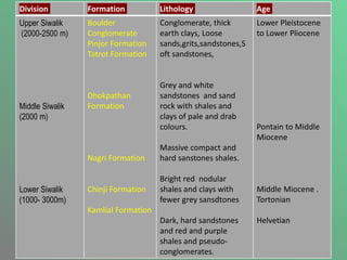
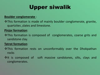
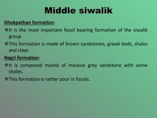
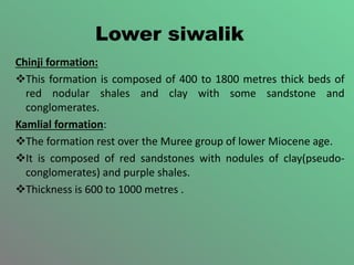
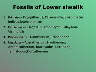
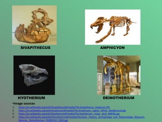
The document provides information about the Siwalik supergroup, which is a thick sedimentary sequence that extends throughout the southern Himalayan belt. It summarizes the lithology, distribution, classification, and fossil content of the Siwalik group. Key points include:
- The Siwalik group was deposited in a foreland basin between the middle Miocene to lower Pleistocene periods.
- It is classified into three divisions - upper, middle, and lower Siwalik - based on vertebrate fossils.
- A rich assemblage of fossils has been recovered, including mammals, providing important insights into the evolution of modern species.
- The Siwalik supergroup has significance for
Boundary problems between :-
Precambrian/Cambrian
Permian/Triassic
Cretaceous/Tertiary
Neogene/Quaternary
Stratigraphic boundaries are determined by one or more of geological events such as volcanic activity, sedimentation, tectonism, paleo-environments & evolution of life.
Faunal records have played major role in determining the boundaries of the Phanerozoic units.
The other geological events are dated on the evidence of fossil records.
Kutch is an East-west Oriented pericraton Rift basin Situated between Nagar Parkar Fault in North and Kathiawar Uplift in South.
Here we will discuss Geology and its Sequence Stratigraphy.
A Study on Rock units for Landslide Hazard between Yinmabin and Kalaw areas, ...ijtsrd
The research area is situated along the Thazi Taunggyi road section and Thazi Shwenyaung railway section in western part of the Shan Plateau. It is one of the most socio economically important transportation routes in Myanmar. Most of the land slide hazards occur annually along the pathways for transportation because of the mountainous terrain area with high steep cutting slopes.The study area involves a sequence of Yinmabin metamorphic complex Early Paleozoic , Lebyin Group Early Carboniferous , Plateau Limestone Group Middle Permian Middle Triassic , Loi an Group late Middle Jurassic early Late Jurassic , Pyinnyaung Formation Late Jurassic Early Cretaceous , Kalaw Red Bed Cretaceous and Alluvium Holocene .The various types of rock units are igneous and meta igneous rock units, metamorphic rock units , sedimentary and meta sedimentary rock units. The igneous rock units are also comprised the granitic rocks, dioritic rocks, rhyolite and biotite microgranite. Metamorphic Rock units of Yinmabin Metamorphic Complex are low to medium grade metamorphosed pelitic rocks, medium to high grade metamorphosed quartzo feldspatic rocks and medium grade metamorphosed calcareous rocks. The Lebyin Group consists of greywackes, pebbly mudstone, quartzite and shales. The Plateau Limestone Group is composed of medium to thick bedded, light gray to bluish gray calcitic limestone, dolomic limestones, brecciated limestone and argillaceous calcitic limestone. The two Jurassic units consists of interbedded sequences of sandstone, siltstone, shale. Generally the rocks of the Loi an Group are turbiditic nature of siliciclastic sedimentary rock units. Kalaw Red Beds are totally of continental origin of fluvialtile fanglomeratic deposits containing comglomerate, thin to medium bedded sandstone, siltstone and shale.Moreover, the study area is structurally unstable because it lies in the Shan Scarp Fault Zone. So, most of the landslide types occur in this area. Wedge Failure and plane failure are the common type of landslides and other types occur as minor. Dr. Me Me Thein "A Study on Rock units for Landslide Hazard between Yinmabin and Kalaw areas, Mandalay Region and Shan State (South)" Published in International Journal of Trend in Scientific Research and Development (ijtsrd), ISSN: 2456-6470, Volume-3 | Issue-5 , August 2019, URL: https://www.ijtsrd.com/papers/ijtsrd28041.pdfPaper URL: https://www.ijtsrd.com/humanities-and-the-arts/geography/28041/a-study-on-rock-units-for-landslide-hazard-between-yinmabin-and-kalaw-areas-mandalay-region-and-shan-state-south/dr-me-me-thein
This time the slide rock mainly contains what Huangshan has seen and heard, as well as the resolution of stone sampling and the final understanding of the law.
This is a presentation by Dada Robert in a Your Skill Boost masterclass organised by the Excellence Foundation for South Sudan (EFSS) on Saturday, the 25th and Sunday, the 26th of May 2024.
He discussed the concept of quality improvement, emphasizing its applicability to various aspects of life, including personal, project, and program improvements. He defined quality as doing the right thing at the right time in the right way to achieve the best possible results and discussed the concept of the "gap" between what we know and what we do, and how this gap represents the areas we need to improve. He explained the scientific approach to quality improvement, which involves systematic performance analysis, testing and learning, and implementing change ideas. He also highlighted the importance of client focus and a team approach to quality improvement.
Read| The latest issue of The Challenger is here! We are thrilled to announce that our school paper has qualified for the NATIONAL SCHOOLS PRESS CONFERENCE (NSPC) 2024. Thank you for your unwavering support and trust. Dive into the stories that made us stand out!
2024.06.01 Introducing a competency framework for languag learning materials ...Sandy Millin
http://sandymillin.wordpress.com/iateflwebinar2024
Published classroom materials form the basis of syllabuses, drive teacher professional development, and have a potentially huge influence on learners, teachers and education systems. All teachers also create their own materials, whether a few sentences on a blackboard, a highly-structured fully-realised online course, or anything in between. Despite this, the knowledge and skills needed to create effective language learning materials are rarely part of teacher training, and are mostly learnt by trial and error.
Knowledge and skills frameworks, generally called competency frameworks, for ELT teachers, trainers and managers have existed for a few years now. However, until I created one for my MA dissertation, there wasn’t one drawing together what we need to know and do to be able to effectively produce language learning materials.
This webinar will introduce you to my framework, highlighting the key competencies I identified from my research. It will also show how anybody involved in language teaching (any language, not just English!), teacher training, managing schools or developing language learning materials can benefit from using the framework.
Ethnobotany and Ethnopharmacology:
Ethnobotany in herbal drug evaluation,
Impact of Ethnobotany in traditional medicine,
New development in herbals,
Bio-prospecting tools for drug discovery,
Role of Ethnopharmacology in drug evaluation,
Reverse Pharmacology.
Students, digital devices and success - Andreas Schleicher - 27 May 2024..pptxEduSkills OECD
Andreas Schleicher presents at the OECD webinar ‘Digital devices in schools: detrimental distraction or secret to success?’ on 27 May 2024. The presentation was based on findings from PISA 2022 results and the webinar helped launch the PISA in Focus ‘Managing screen time: How to protect and equip students against distraction’ https://www.oecd-ilibrary.org/education/managing-screen-time_7c225af4-en and the OECD Education Policy Perspective ‘Students, digital devices and success’ can be found here - https://oe.cd/il/5yV
The Indian economy is classified into different sectors to simplify the analysis and understanding of economic activities. For Class 10, it's essential to grasp the sectors of the Indian economy, understand their characteristics, and recognize their importance. This guide will provide detailed notes on the Sectors of the Indian Economy Class 10, using specific long-tail keywords to enhance comprehension.
For more information, visit-www.vavaclasses.com
Welcome to TechSoup New Member Orientation and Q&A (May 2024).pdfTechSoup
In this webinar you will learn how your organization can access TechSoup's wide variety of product discount and donation programs. From hardware to software, we'll give you a tour of the tools available to help your nonprofit with productivity, collaboration, financial management, donor tracking, security, and more.
2. Content
Introduction
Lithology
Distribution
Classification
Fossils of siwalik
Vertebrate Fossil
Importance of siwalik super group
SIGNIFICANCE
Bibilography
3. Introduction
The Siwalik group is a thick sedimentary sequence, which
extends throughout the East-West of the Southern
Himalayan belt that represents the youngest mountain belt,
and is bounded by the main Boundary thrust in the North
and the Himalayan frontal thrust in the south and is
separated from the lesser Himalaya in the north and the
indo Gangetic plain in the south.
The sediments of the siwalik group were deposited in a
foreland basin of the Himalayas between middle Miocene to
lower Pleistocene
The name siwalik was originally given by captain P.T Cautely
in 1832.
4. Lithology
The Siwalik system is a great thickness of detrital of rocks such as
coarsely bedded sandstones, sand rocks, clays and conglomerates
measuring between 4500 – 5200 meters in thickness.
The bulk of the formation as already stated is very closely similar to the
materials constituting the modern alluvia of river except that the
former is somewhat compacted has undergone folding and faulting
movements, and is now resting at higher levels with high angles of dip.
The lithology of the Siwaliks suggests their origin; they are chiefly the
water –worn debris of the granitic core of the central Himalya ,
deposited in the long and broad valley of the “siwalik river” .
The Siwalik rocks are involved in the Himalayan orogeny, they are
folded, faulted and even overturned and thrusted.
5. Distribution
The siwalik hills are located in the political
boundaries of Pakistan, India, Nepal and Bhutan
and range between 6 to 90 km in width.
They gradually become steeper and narrower in
relief and width respectively, from northern
Pakistan to Bhutan( over 2000 km in length) .
7. Siwalik group in India
1. Jammu and Kashmir:
Complete development of Siwalik can be seen in Jammu hills
2. Himachal Pradesh:
Siwalik group in Himachal Himalya from a parallel foothill belt along
the southern margin between Ravi and Yamuna river.
3. Uttararkhand:
Kalagarh basin
4. West Bengal:
In the Terai region of the northern part of Jalpaiguri and Darjleeing
district of West Bengal
5. Assam:
Cachar hills
6.Arunachal Pradesh:
Mishmi hills
8. Classification
On Palaeontological grounds the systems is divisible into
3 sections, the passage of the one into the other division
being, however quite gradual and transitional.
One of the basis vertebrate Fauna the siwalik group has
been classified into three divisions:
1. Upper siwalik
2. Middle siwalik
3. Lower siwalik
9. Division Formation Lithology Age
Upper Siwalik
(2000-2500 m)
Middle Siwalik
(2000 m)
Lower Siwalik
(1000- 3000m)
Boulder
Conglomerate
Pinjor Formation
Tatrot Formation
Dhokpathan
Formation
Nagri Formation
Chinji Formation
Kamlial Formation
Conglomerate, thick
earth clays, Loose
sands,grits,sandstones,S
oft sandstones,
Grey and white
sandstones and sand
rock with shales and
clays of pale and drab
colours.
Massive compact and
hard sanstones shales.
Bright red nodular
shales and clays with
fewer grey sansdtones
Dark, hard sandstones
and red and purple
shales and pseudo-
conglomerates.
Lower Pleistocene
to Lower Pliocene
Pontain to Middle
Miocene
Middle Miocene .
Tortonian
Helvetian
10. Upper siwalik
Boulder conglomerate :
This formation is made of mainly boulder conglomerate, granite,
quartzites ,slates and limestone.
Pinjor formation:
This formation is composed of conglomerates, coarse grits and
sandstone clay.
Tatrot formation:
This formation rests on unconformably over the Dhokpathan
rocks
It is composed of soft massive sandstones, silts, clays and
conglomerates.
11. Middle siwalik
Dhokpathan formation:
It is the most important fossil bearing formation of the siwalik
group
This formation is made of brown sandstones, gravel beds, shales
and clays.
Nagri formation:
It is composed mainly of massive grey sandstone with some
shales.
This formation is rather poor in fosslis.
12. Lower siwalik
Chinji formation:
This formation is composed of 400 to 1800 metres thick beds of
red nodular shales and clay with some sandstone and
conglomerates.
Kamlial formation:
The formation rest over the Muree group of lower Miocene age.
It is composed of red sandstones with nodules of clay(pseudo-
conglomerates) and purple shales.
Thickness is 600 to 1000 metres .
13. Fossils Of siwalik
1.Upper siwalik:
i. 1. Primates – Simia , Semnopithecus, Papio
ii. 2. Carnivores – Hyaenrctos, Sivalenis,Mellivora, Mustela,
Lutra, Canis,Vulpes, Hyaena, Crocuta
iii. 3. Elephants – Mastodon, Sivalensis , Stegodon, Ganes
iv. 4. Ungulates – Rhinoceros Palaeindicus, Equuss Sivalemsis,
Susfalconeri, Hippopotamus, Cervus, Bucapra, Anoa
19. Vertebrate fossils
Fossils are disarticulated in nature.
Most durable parts are commonly preserved as
fossils of vertebrates are their bones,teeths and their
footprints.
A rich assemblage of fossil has been recovered from
the Siwalik rock which has given this system a very
important status in Indian startigraphy. Most of the
stages in Siwalik system are typically rich in
mammalian fossils.
20. Geo world Heritage site of Siwalik Himachal
Pradesh Suketi fossil National park
•Image sources
•https://i0.wp.com/thejerker.com/wp-content/uploads/2021/06/suketi2.jpg?w=650&ssl=1
21. Importance Of Siwalik Supergroup
• The Siwalik supergroup has huge deposits of
calcium,carbonate and of important minerals
such as iron,sulfur and copper; the deposits
however,are generally of sub-economic grades
that currently are not worth exploting.
22. Significance
1. Evolution of different modern species.
2. Useful for correlation purpose in continental region.
3. History and culture.
4. Paleoclimatology,paleobiogeography and paleoecology.
23. BIBLIOGRAPHY :
1. GEOLOGY OF INDIA BY – D.N. WADIA
2. A TEXTBOOK OF ENGINEERING GEOLOGY
BY- K.M. BANGAR