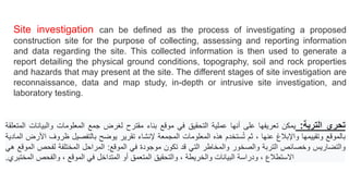
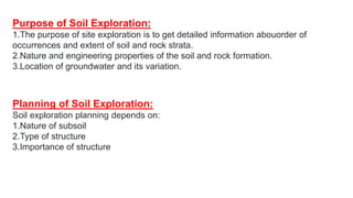
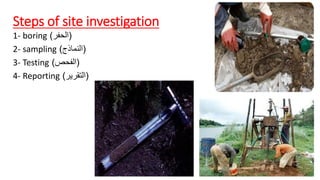
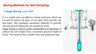
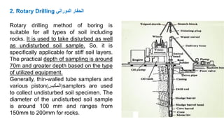
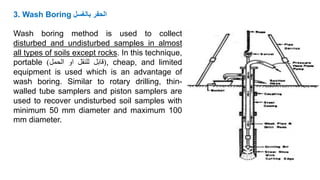
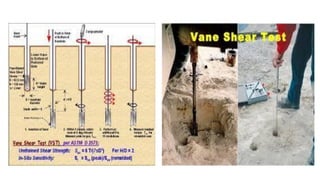
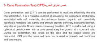
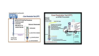
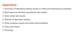
Site investigation involves collecting data about physical ground conditions, topography, soil and rock properties, and hazards at a proposed construction site. This is done through various stages including reconnaissance, data and map study, intrusive site investigation, and laboratory testing. The collected information is used to generate a report detailing the site conditions. Common methods for site investigation include boring, sampling, field testing such as standard penetration testing, vane shear testing and cone penetration testing, and laboratory testing of soil samples. The purpose is to obtain detailed information about soil and rock strata occurrences, properties, and groundwater conditions to inform site planning and construction.
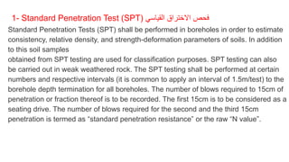
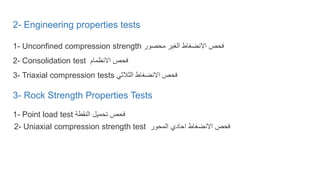
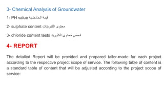
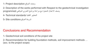
methods of sub-surface exploration, methods of boring, number, location and d...Prajakta Lade
This document discusses methods of subsurface exploration for geotechnical engineering projects. It describes various boring methods like auger boring, wash boring, percussion boring, and rotary drilling used to investigate subsurface soil and rock conditions. The number, location, and depth of borings depends on the type and size of the structure, with minimum depths provided for different foundation types like shallow and deep foundations. Subsurface exploration is important to evaluate soil properties, groundwater levels, and other geological factors for foundation design and construction.
Soil exploration methods and soil investigation reportAnjana R Menon
Soil exploration involves site investigations through methods like boreholes, test pits, and geophysical tests. This provides critical information on ground conditions like soil type, bearing capacity, and water levels for foundation design of structures. The objectives are to evaluate soil properties, predict issues, ensure safety, and select suitable construction methods. A proper exploration program involves reconnaissance, preliminary, and sometimes detailed investigations using appropriate testing and sampling methods based on the project size and soil variability.
The document summarizes information about the cone penetration test (CPT), a method used to determine geotechnical engineering properties of soils. It provides a brief history of the CPT, describing how it has evolved from a mechanical cone in the 1930s to electric cones in the 1960s. It then explains that the CPT involves pushing a cone tip into the ground to continuously measure resistance, and describes the components of the CPT device and how the test is conducted. Finally, it outlines the advantages and disadvantages of the CPT and how the results can be used to evaluate soil types, densities, and shear strengths for foundation design purposes.
The standard penetration test (SPT) involves driving a split spoon sampler into the ground using a 140 lb hammer dropped 30 inches. The number of blows required to penetrate each 6 inch interval is recorded, and the penetration resistance value N is the sum of the blows over the second and third intervals. This test is commonly used to obtain bearing capacity and estimate soil properties like density and shear strength. It is performed whenever the soil stratum changes and at intervals of no more than 1.5 meters.
Tunnelling is a serious engineering project.
In addition to large investment cost, the challenges related to long and deep tunnels are considerable.
Important aspects which needs to be considered are related to the construction works, geology, environment and operation. his module highlights all these aspects.
This document presents information about static cone penetration tests. It discusses the principles and applications of cone penetration testing. The principles section explains that a metal cone is penetrated into the subsurface at a constant rate, and the cone tip resistance, sleeve friction, and friction ratio are recorded to determine soil stratigraphy and properties. The applications section notes that data is used to estimate parameters like undrained shear strength and stress history, and that results can be directly applied to soil profiling and engineering designs.
This document provides an overview of laboratory and field testing methods for rocks. It discusses index property tests such as unit weight, porosity, permeability, electrical resistivity, and sonic velocity that are used to characterize and classify rocks. It also describes mechanical property tests like unconfined compressive strength testing, triaxial testing, point load strength testing, and beam bending tests. Common field testing methods mentioned include pressuremeter testing, in-situ direct shear testing, and hydraulic fracturing. The document provides details on sample preparation, equipment used, procedures, and how to calculate and interpret results for different rock property tests.
The document lists the group members and registration numbers for a presentation on geotechnical investigation. It includes an outline of the presentation topics which are an introduction to soil exploration, investigation phases, exploration methods, soil sampling, amount of exploration needed, in-situ tests, planning an investigation, and records/reports. The key topics to be covered are the purpose of soil exploration, direct and indirect exploration methods such as test pits and boreholes, sampling disturbed and undisturbed soil samples, and planning the exploration program.
1. Canals are constructed to carry water from rivers or reservoirs to irrigate fields. They are generally aligned along contours, ridges, or side slopes.
2. Contour canals follow elevation contours except for the required slope, allowing irrigation on one side. Ridge canals along dividing ridges allow irrigation on both sides.
3. Side slope canals run perpendicular to contours, parallel to natural drainage, avoiding the need for cross drainage structures. Proper geological investigation is important for determining appropriate canal alignments and designs.
This document discusses subsoil exploration, which involves collecting soil data through field and laboratory investigations to assess soil properties at a site. The main objectives are to determine the nature, depth, thickness, and extent of soil strata, as well as groundwater depth and properties. Exploration methods include direct techniques like test pits and borings, and indirect techniques like sounding tests and geophysical methods. Standard penetration tests are commonly used to determine properties of cohesionless soils by counting blows required to penetrate the soil. Corrections are applied to penetration values to account for overburden pressure and sample dilatancy.
This document provides an overview of site investigation procedures for determining subsurface soil conditions. It discusses the purposes of site investigations, which include selecting foundation types, evaluating load capacity, estimating settlements, and determining potential foundation problems. The exploration program aims to determine soil stratification and engineering properties through borings, samples, and field tests. Standard procedures are outlined for boring depth and spacing, soil and rock sampling methods, groundwater level determination, and field strength tests like SPT, CPT, and PLT.
The document discusses various methods for soil exploration including test trenches, auger and wash boring, rotary drilling, and geophysical methods. It describes common stages of site investigation such as desk study, field investigations including preliminary and detailed ground investigation, laboratory testing, and report writing. Various purposes of soil investigation are provided such as selection of foundation type, design of foundations, and planning of construction techniques. Different methods of investigation like test pits, auger boring, wash boring, and rotary drilling are explained. The document also discusses soil sampling methods, laboratory testing, and structuring a test schedule.
index properties of soil, Those properties of soil which are used in the identification and classification of soil are known as INDEX PROPERTIES
Water content
Specific gravity
In-situ density
Particle size
Consistency
Relative Density
Site investigation involves determining the soil layers and properties beneath a proposed structure. It helps select the foundation type, evaluate load capacity, estimate settlement, and identify potential issues. The exploration program uses methods like boreholes, test pits, and probes to characterize soil stratification, strength, deformation, and groundwater. Proper planning is needed to obtain reliable data at minimum cost.
This document discusses stresses in soils due to applied loads using Boussinesq's theory. It provides the assumptions and equations for calculating vertical stresses due to concentrated point loads, line loads, and strip loads on the surface of a semi-infinite elastic medium. The stresses decrease with distance from the load and depth below the surface. Pressure distribution diagrams and isobars are used to illustrate the stress distributions. Numerical examples are provided to demonstrate calculating stresses at points below different load configurations.
This document summarizes methods of sub-soil exploration for foundation engineering. It discusses various direct and indirect exploration techniques including pits, trenches, borings, percussion drilling, and electrical resistivity methods. Planning of exploration programs involves determining depth based on structure type and significant depth, as well as lateral spacing of bore holes. The objectives of exploration are to select foundations, determine bearing capacity, and investigate existing structures.
This document discusses soil sampling and exploration. It describes different types of soil samples including disturbed, undisturbed, representative and non-representative samples. It discusses criteria for obtaining undisturbed samples and transporting and preserving samples. Different types of soil samplers are described. Factors related to planning a soil exploration program such as spacing and depth of borings are covered. Components of a soil exploration report are outlined.
This document discusses the index properties of soil, which can be divided into soil grain properties and soil aggregate properties. Soil grain properties depend on individual grains and are independent of formation, including mineral composition, specific gravity, grain size and shape. Soil aggregate properties depend on the soil mass as a whole and represent collective behavior, influenced by stress history, formation and structure. Common index properties discussed include grain size distribution, Atterberg limits which classify soil consistency, and plasticity index. Engineering applications of index properties include soil classification, permeability estimation, and criteria for materials selection.
Necessity/advantage of a tunnel, Classification of Tunnels,
Size and shape of a tunnel, Alignment of a Tunnel, Portals and Shafts,
Methods of Tunneling in Hard Rock and Soft ground, Mucking, Lighting
and Ventilation in tunnel, Dust control, Drainage of tunnels, Safety in
tunnel construction.
A site investigation simply is the process of the collection of information, the appraisal of data, assessment, and reporting without which the hazards in the ground beneath the site cannot be known
The document discusses the phases and methods of subsurface exploration to determine the soil layers and properties beneath a proposed structure. It describes 5 phases: collection of existing information, reconnaissance survey, preliminary exploration, detailed exploration, and report writing. Common exploration methods are discussed, including trial pits, hand augers, mechanical augers like bucket and continuous flight augers, and drilling rigs. Factors to consider for the depth, number, and spacing of boreholes include the structure type and loads, soil variability, and cost-effectiveness. The goal is to safely characterize subsurface conditions for foundation design.
1. The document discusses slope stability analysis using the Swedish slip circle method for analyzing finite slopes made of cohesive soils.
2. It describes the assumptions of the method and calculates the factors of safety for circular failure surfaces with and without tension cracks.
3. The document also covers other methods like the ordinary method of slices for c-f soils and discusses locating the critical slip circle using empirical relationships.
Drilling methods are used in construction and mining to drill holes in rock and earth. There are various types of drilling including rotary, percussion, and rotary-percussion. Rotary drilling uses rotation to cut holes while percussion drilling uses repeated impact force. Different drilling methods and equipment are suited to different applications depending on factors like the rock properties and depth of drilling required. Common drilling equipment includes jackhammers, stopers, drifters, and wagon drills which can be powered pneumatically, hydraulically, or electrically.
The document discusses various methods of soil exploration including borings, test pits, and geophysical methods. It describes the objectives of soil exploration as determining the suitable foundation type, bearing capacity, and other factors. The key methods discussed are displacement boring, wash boring, auger boring, rotary drilling, percussion drilling, and continuous sampling boring. Each method is explained along with its suitable soil conditions, advantages, and limitations.
This document describes the procedure for conducting a plate load test to determine the bearing capacity of soil. Key details include:
- Plate load tests involve gradually applying load increments to a steel plate placed on the ground and measuring settlement over time.
- Tests are used to determine ultimate bearing capacity and modulus of subgrade reaction for foundation design.
- Proper test setup, equipment, load increments, settlement observations and timing are specified.
- Results are interpreted by plotting load-settlement curves to identify yield point or failure for different soil types.
- Calculations are provided to determine ultimate bearing capacity and expected foundation settlement from plate load test data.
- Limitations include only reflecting shallow soil properties and not fully capturing ultimate
The document discusses site investigation methods for assessing soil conditions, which include topographic surveys, soil exploration techniques like test pits and boreholes, in-situ tests, and collecting representative soil samples. The goal of the investigation is to determine soil properties and stratigraphy, groundwater conditions, and suitability of the site for construction in order to inform design and construction and address potential problems. The extent and methods used depend on factors like site conditions, project nature, time and budget available for the investigation.
This presentation is useful for GTU students in Building Construction subject in Subsurface investigation the popular topic in syllabus, this includes more images which will help to students & researchers for same.
The document discusses subsurface investigations for foundations. It describes various methods used for soil exploration including test pits, borings, geophysical methods, and in-situ tests. The key methods covered are auger boring, wash boring, rotary drilling, percussion drilling, standard penetration test, and cone penetration test. The document also discusses planning exploration programs, sampling techniques, factors affecting depth and spacing of boreholes, and interpretation of soil exploration data for foundation design.
Lecture about foundation engineering.pptxambipathi1986
This document discusses site investigation and subsoil exploration methods for foundation engineering. It describes the objectives of site investigation as determining surface and subsurface conditions to assess site suitability and aid in design. Key methods discussed include reconnaissance, maps, aerial photography, test pits, auger borings, wash borings, rotary drilling, and percussion drilling. The spacing and depth of borings depends on the structure type and importance, soil conditions, and previous investigations. The goal is to characterize soil/rock strata, groundwater, and obtain samples to inform foundation design.
Civil engineering materials & Construction - Soil explorationsGowtham G
This document provides information about site investigation and ground improvement techniques. It discusses the importance of site investigation, which involves preliminary investigations like reconnaissance and studying maps to understand soil conditions. Methods of site exploration include direct methods like test pits and indirect methods like the standard penetration test. The document also covers ground improvement techniques, noting the importance of determining a soil's safe bearing capacity. It discusses methods to test bearing capacity, like plate loading tests, and techniques to improve poor soils, as governed by relevant Indian Standards.
Subsoil exploration involves laboratory and field investigations to assess soil properties at a site. It determines the nature, depth, and thickness of soil strata as well as groundwater conditions and engineering properties. Methods include test pits, boreholes using augers or drilling, in-situ tests like SPT and CPT, and geophysical methods such as seismic refraction and electrical resistivity testing. The results are used to select appropriate foundation types and determine bearing capacity.
The document provides information about soil exploration/site investigation. It discusses the objectives, stages, methods, and importance of soil exploration. Some key points:
- Soil exploration involves determining the soil profile and properties at a construction site. It aims to select suitable foundations and construction methods.
- The stages include initial site reconnaissance, preliminary exploration with simple tests, and detailed exploration with complex in-situ and laboratory tests.
- Common exploration methods include excavating trial pits, drilling boreholes using augers, wash boring, rotary drilling, and percussion drilling. Samples are collected and tested.
- A report is prepared providing details of the exploration process and results, as well as foundation and construction recommendations
Landslide investigation in field. describe the procedure to find the shallow or large scale landslide in field. To understand Landslide you should walk through whole Landslide.
The document discusses site investigation, which involves gathering subsurface information about a proposed construction project location. It describes the purpose, scope, and stages of a site investigation. The typical stages are a desk study, preliminary investigation including some boreholes, a detailed investigation with more boreholes and sampling, and monitoring during construction. Common investigation methods discussed are the standard penetration test, cone penetration test, and sampling techniques.
About Subsurface investigation, Depth of foundation, Significant depth, Types of investigation, Steps involved, Methods of boring, Types of samples and samplers, Core recovery and RQD.
1. Site Investgation.pptxDebre Markos University Technology College Departmen...teseraaddis1
Soil Exploration
“ The process of exploring to characterize or define small scale properties of substrata at construction sites is unique to geotechnical engineering.
In other engineering disciplines, material properties are specified during design, or before construction or manufacture, and then controlled to meet the specification. Unfortunately, subsurface properties cannot be specified; they must be deduced through exploration.” Charles H. Dowding (1979).
م.36
مبادرة
#تواصل_تطوير
المحاضرة السادسة والثلاثون من المبادرة مع
الاستاذ الدكتور/ محمد حسنين ربيع
عميد كلية هندسة المطرية جامعة حلوان
استاذ ميكانيكا التربة والأساسات
بعنوان
استكشاف التربة بالطرق المتقدمة
Advanced Soil Investigation
التاسعة مساء بتوقيت مكة المكرمة الأربعاء 22يوليو2020
وذلك عبر تطبيق زووم من خلال الرابط
https://us02web.zoom.us/meeting/register/tZIoc-qqqDsuGdFdDj1kcvshAZ0jqbCbURBB
علما ان هناك بث مباشر للمحاضرة على صفحة فيس بوك
وقناة يوتيوب الخاصة بجمعية المهندسين المصريين
رابط قناة اليوتيوب
https://www.youtube.com/user/EEAchannal
للتواصل مع إدارة المبادرة عبر قناة التليجرام
https://t.me/EEAKSA
رابط اللينكدان والمكتبة الالكترونية
https://www.linkedin.com/company/eeaksa-egyptian-engineers-association/
رابط حساب تويتر
https://twitter.com/eeaksa
رابط التسجيل العام للمحاضرات
https://forms.gle/vVmw7L187tiATRPw9
The document discusses various methods of soil exploration including borings, test pits, and geophysical methods. It describes the objectives of soil exploration as determining the suitable foundation type, bearing capacity, and other factors. The key methods discussed are displacement boring, wash boring, auger boring, rotary drilling, percussion drilling, and continuous sampling boring. Each method is suited to different soil conditions and provides varying sample quality and depth capability.
The document discusses soil investigation methods used to characterize soil properties for engineering projects. It describes different soil horizons defined by composition and depth. Key soil characteristics discussed include color, texture, aggregation, porosity, ion content, and pH. Common soil investigation techniques are also summarized, such as trial pitting, dynamic probe testing, cable percussive boreholes, and rotary drilled boreholes. The purposes of soil investigations are to determine suitability for construction and adequate foundation design while anticipating difficulties.
This document provides an overview of foundation engineering and soil exploration. It discusses what a foundation and foundation engineering are, as well as the different types of foundations. It also defines what soil is and explains the process of soil exploration. Various methods of soil exploration are described, including test pits, boreholes, and field tests like the standard penetration test. The stages of subsurface investigation are outlined. Finally, it covers sampling methods and the importance of obtaining both disturbed and undisturbed samples for laboratory testing.
This document provides an overview of subsurface exploration, which involves site investigation and soil exploration to assess soil conditions for engineering projects. It discusses the objectives, phases and methods of subsurface exploration. The main methods covered are open excavation techniques like test pits and trenches, as well as boring techniques like auger, wash, percussion and rotary boring. It also describes different sampling techniques for obtaining disturbed and undisturbed soil samples, and different types of in-situ tests like standard penetration tests and cone penetration tests.
Site investigation involves determining the soil layers and properties beneath a proposed structure. It helps select the foundation type and depth, evaluate load capacity, estimate settlement, and identify potential issues. The exploration program uses methods like test pits, auger and wash borings, probing, and geophysics to obtain samples and measure properties. A site investigation includes planning borings and tests, executing fieldwork, and reporting the findings and recommendations.
Applications of artificial Intelligence in Mechanical Engineering.pdfAtif Razi
Historically, mechanical engineering has relied heavily on human expertise and empirical methods to solve complex problems. With the introduction of computer-aided design (CAD) and finite element analysis (FEA), the field took its first steps towards digitization. These tools allowed engineers to simulate and analyze mechanical systems with greater accuracy and efficiency. However, the sheer volume of data generated by modern engineering systems and the increasing complexity of these systems have necessitated more advanced analytical tools, paving the way for AI.
AI offers the capability to process vast amounts of data, identify patterns, and make predictions with a level of speed and accuracy unattainable by traditional methods. This has profound implications for mechanical engineering, enabling more efficient design processes, predictive maintenance strategies, and optimized manufacturing operations. AI-driven tools can learn from historical data, adapt to new information, and continuously improve their performance, making them invaluable in tackling the multifaceted challenges of modern mechanical engineering.
Null Bangalore | Pentesters Approach to AWS IAMDivyanshu
#Abstract:
- Learn more about the real-world methods for auditing AWS IAM (Identity and Access Management) as a pentester. So let us proceed with a brief discussion of IAM as well as some typical misconfigurations and their potential exploits in order to reinforce the understanding of IAM security best practices.
- Gain actionable insights into AWS IAM policies and roles, using hands on approach.
#Prerequisites:
- Basic understanding of AWS services and architecture
- Familiarity with cloud security concepts
- Experience using the AWS Management Console or AWS CLI.
- For hands on lab create account on [killercoda.com](https://killercoda.com/cloudsecurity-scenario/)
# Scenario Covered:
- Basics of IAM in AWS
- Implementing IAM Policies with Least Privilege to Manage S3 Bucket
- Objective: Create an S3 bucket with least privilege IAM policy and validate access.
- Steps:
- Create S3 bucket.
- Attach least privilege policy to IAM user.
- Validate access.
- Exploiting IAM PassRole Misconfiguration
-Allows a user to pass a specific IAM role to an AWS service (ec2), typically used for service access delegation. Then exploit PassRole Misconfiguration granting unauthorized access to sensitive resources.
- Objective: Demonstrate how a PassRole misconfiguration can grant unauthorized access.
- Steps:
- Allow user to pass IAM role to EC2.
- Exploit misconfiguration for unauthorized access.
- Access sensitive resources.
- Exploiting IAM AssumeRole Misconfiguration with Overly Permissive Role
- An overly permissive IAM role configuration can lead to privilege escalation by creating a role with administrative privileges and allow a user to assume this role.
- Objective: Show how overly permissive IAM roles can lead to privilege escalation.
- Steps:
- Create role with administrative privileges.
- Allow user to assume the role.
- Perform administrative actions.
- Differentiation between PassRole vs AssumeRole
Try at [killercoda.com](https://killercoda.com/cloudsecurity-scenario/)
Comparative analysis between traditional aquaponics and reconstructed aquapon...bijceesjournal
The aquaponic system of planting is a method that does not require soil usage. It is a method that only needs water, fish, lava rocks (a substitute for soil), and plants. Aquaponic systems are sustainable and environmentally friendly. Its use not only helps to plant in small spaces but also helps reduce artificial chemical use and minimizes excess water use, as aquaponics consumes 90% less water than soil-based gardening. The study applied a descriptive and experimental design to assess and compare conventional and reconstructed aquaponic methods for reproducing tomatoes. The researchers created an observation checklist to determine the significant factors of the study. The study aims to determine the significant difference between traditional aquaponics and reconstructed aquaponics systems propagating tomatoes in terms of height, weight, girth, and number of fruits. The reconstructed aquaponics system’s higher growth yield results in a much more nourished crop than the traditional aquaponics system. It is superior in its number of fruits, height, weight, and girth measurement. Moreover, the reconstructed aquaponics system is proven to eliminate all the hindrances present in the traditional aquaponics system, which are overcrowding of fish, algae growth, pest problems, contaminated water, and dead fish.
Rainfall intensity duration frequency curve statistical analysis and modeling...bijceesjournal
Using data from 41 years in Patna’ India’ the study’s goal is to analyze the trends of how often it rains on a weekly, seasonal, and annual basis (1981−2020). First, utilizing the intensity-duration-frequency (IDF) curve and the relationship by statistically analyzing rainfall’ the historical rainfall data set for Patna’ India’ during a 41 year period (1981−2020), was evaluated for its quality. Changes in the hydrologic cycle as a result of increased greenhouse gas emissions are expected to induce variations in the intensity, length, and frequency of precipitation events. One strategy to lessen vulnerability is to quantify probable changes and adapt to them. Techniques such as log-normal, normal, and Gumbel are used (EV-I). Distributions were created with durations of 1, 2, 3, 6, and 24 h and return times of 2, 5, 10, 25, and 100 years. There were also mathematical correlations discovered between rainfall and recurrence interval.
Findings: Based on findings, the Gumbel approach produced the highest intensity values, whereas the other approaches produced values that were close to each other. The data indicates that 461.9 mm of rain fell during the monsoon season’s 301st week. However, it was found that the 29th week had the greatest average rainfall, 92.6 mm. With 952.6 mm on average, the monsoon season saw the highest rainfall. Calculations revealed that the yearly rainfall averaged 1171.1 mm. Using Weibull’s method, the study was subsequently expanded to examine rainfall distribution at different recurrence intervals of 2, 5, 10, and 25 years. Rainfall and recurrence interval mathematical correlations were also developed. Further regression analysis revealed that short wave irrigation, wind direction, wind speed, pressure, relative humidity, and temperature all had a substantial influence on rainfall.
Originality and value: The results of the rainfall IDF curves can provide useful information to policymakers in making appropriate decisions in managing and minimizing floods in the study area.
DEEP LEARNING FOR SMART GRID INTRUSION DETECTION: A HYBRID CNN-LSTM-BASED MODELijaia
As digital technology becomes more deeply embedded in power systems, protecting the communication
networks of Smart Grids (SG) has emerged as a critical concern. Distributed Network Protocol 3 (DNP3)
represents a multi-tiered application layer protocol extensively utilized in Supervisory Control and Data
Acquisition (SCADA)-based smart grids to facilitate real-time data gathering and control functionalities.
Robust Intrusion Detection Systems (IDS) are necessary for early threat detection and mitigation because
of the interconnection of these networks, which makes them vulnerable to a variety of cyberattacks. To
solve this issue, this paper develops a hybrid Deep Learning (DL) model specifically designed for intrusion
detection in smart grids. The proposed approach is a combination of the Convolutional Neural Network
(CNN) and the Long-Short-Term Memory algorithms (LSTM). We employed a recent intrusion detection
dataset (DNP3), which focuses on unauthorized commands and Denial of Service (DoS) cyberattacks, to
train and test our model. The results of our experiments show that our CNN-LSTM method is much better
at finding smart grid intrusions than other deep learning algorithms used for classification. In addition,
our proposed approach improves accuracy, precision, recall, and F1 score, achieving a high detection
accuracy rate of 99.50%.
Prediction of Electrical Energy Efficiency Using Information on Consumer's Ac...PriyankaKilaniya
Energy efficiency has been important since the latter part of the last century. The main object of this survey is to determine the energy efficiency knowledge among consumers. Two separate districts in Bangladesh are selected to conduct the survey on households and showrooms about the energy and seller also. The survey uses the data to find some regression equations from which it is easy to predict energy efficiency knowledge. The data is analyzed and calculated based on five important criteria. The initial target was to find some factors that help predict a person's energy efficiency knowledge. From the survey, it is found that the energy efficiency awareness among the people of our country is very low. Relationships between household energy use behaviors are estimated using a unique dataset of about 40 households and 20 showrooms in Bangladesh's Chapainawabganj and Bagerhat districts. Knowledge of energy consumption and energy efficiency technology options is found to be associated with household use of energy conservation practices. Household characteristics also influence household energy use behavior. Younger household cohorts are more likely to adopt energy-efficient technologies and energy conservation practices and place primary importance on energy saving for environmental reasons. Education also influences attitudes toward energy conservation in Bangladesh. Low-education households indicate they primarily save electricity for the environment while high-education households indicate they are motivated by environmental concerns.
Redefining brain tumor segmentation: a cutting-edge convolutional neural netw...IJECEIAES
Medical image analysis has witnessed significant advancements with deep learning techniques. In the domain of brain tumor segmentation, the ability to
precisely delineate tumor boundaries from magnetic resonance imaging (MRI)
scans holds profound implications for diagnosis. This study presents an ensemble convolutional neural network (CNN) with transfer learning, integrating
the state-of-the-art Deeplabv3+ architecture with the ResNet18 backbone. The
model is rigorously trained and evaluated, exhibiting remarkable performance
metrics, including an impressive global accuracy of 99.286%, a high-class accuracy of 82.191%, a mean intersection over union (IoU) of 79.900%, a weighted
IoU of 98.620%, and a Boundary F1 (BF) score of 83.303%. Notably, a detailed comparative analysis with existing methods showcases the superiority of
our proposed model. These findings underscore the model’s competence in precise brain tumor localization, underscoring its potential to revolutionize medical
image analysis and enhance healthcare outcomes. This research paves the way
for future exploration and optimization of advanced CNN models in medical
imaging, emphasizing addressing false positives and resource efficiency.
Software Engineering and Project Management - Introduction, Modeling Concepts...Prakhyath Rai
Introduction, Modeling Concepts and Class Modeling: What is Object orientation? What is OO development? OO Themes; Evidence for usefulness of OO development; OO modeling history. Modeling
as Design technique: Modeling, abstraction, The Three models. Class Modeling: Object and Class Concept, Link and associations concepts, Generalization and Inheritance, A sample class model, Navigation of class models, and UML diagrams
Building the Analysis Models: Requirement Analysis, Analysis Model Approaches, Data modeling Concepts, Object Oriented Analysis, Scenario-Based Modeling, Flow-Oriented Modeling, class Based Modeling, Creating a Behavioral Model.
AI for Legal Research with applications, toolsmahaffeycheryld
AI applications in legal research include rapid document analysis, case law review, and statute interpretation. AI-powered tools can sift through vast legal databases to find relevant precedents and citations, enhancing research accuracy and speed. They assist in legal writing by drafting and proofreading documents. Predictive analytics help foresee case outcomes based on historical data, aiding in strategic decision-making. AI also automates routine tasks like contract review and due diligence, freeing up lawyers to focus on complex legal issues. These applications make legal research more efficient, cost-effective, and accessible.
Discover the latest insights on Data Driven Maintenance with our comprehensive webinar presentation. Learn about traditional maintenance challenges, the right approach to utilizing data, and the benefits of adopting a Data Driven Maintenance strategy. Explore real-world examples, industry best practices, and innovative solutions like FMECA and the D3M model. This presentation, led by expert Jules Oudmans, is essential for asset owners looking to optimize their maintenance processes and leverage digital technologies for improved efficiency and performance. Download now to stay ahead in the evolving maintenance landscape.
Gas agency management system project report.pdfKamal Acharya
The project entitled "Gas Agency" is done to make the manual process easier by making it a computerized system for billing and maintaining stock. The Gas Agencies get the order request through phone calls or by personal from their customers and deliver the gas cylinders to their address based on their demand and previous delivery date. This process is made computerized and the customer's name, address and stock details are stored in a database. Based on this the billing for a customer is made simple and easier, since a customer order for gas can be accepted only after completing a certain period from the previous delivery. This can be calculated and billed easily through this. There are two types of delivery like domestic purpose use delivery and commercial purpose use delivery. The bill rate and capacity differs for both. This can be easily maintained and charged accordingly.
2. Site investigation can be defined as the process of investigating a proposed
construction site for the purpose of collecting, assessing and reporting information
and data regarding the site. This collected information is then used to generate a
report detailing the physical ground conditions, topography, soil and rock properties
and hazards that may present at the site. The different stages of site investigation are
reconnaissance, data and map study, in-depth or intrusive site investigation, and
laboratory testing.
تحري
التربة
:
ي
مكن
تعريفها
على
أنها
عملية
التحقيق
في
موقع
بناء
مقترح
لغرض
جمع
المعلومات
والبيانات
المتعلقة
بالموقع
وتقييمها
واإلبالغ
عنها
،
ثم
ستخدمُت
هذه
المعلومات
المجمعة
إلنشاء
تقرير
يوضح
بالتفصيل
ظروف
األرض
المادي
ة
والتضاريس
وخصائص
التربة
والصخور
والمخاطر
التي
قد
تكون
موجودة
في
الموقع
:
المراحل
المختلفة
لفحص
الموقع
هي
االستطالع
،
ودراسة
البيانات
والخريطة
،
والتحقيق
المتعمق
أو
المتداخل
في
الموقع
،
وال
فحص
المختبري
.
3. Purpose of Soil Exploration:
1.The purpose of site exploration is to get detailed information abouorder of
occurrences and extent of soil and rock strata.
2.Nature and engineering properties of the soil and rock formation.
3.Location of groundwater and its variation.
Planning of Soil Exploration:
Soil exploration planning depends on:
1.Nature of subsoil
2.Type of structure
3.Importance of structure
5. 1- Boring methods: are widely used for subsurface investigations to collect
samples, in almost all types of soil, for visual inspection or laboratory testing. There
are several boring techniques like auger boring (
الحفر
بالمثقاب
) , rotary drilling (
الحفار
الدوراني
) , wash boring (
الحفر
بالغسل
) , percussion drilling (
الحفر
بالدق
) , auger drilling المثقاب
اليدوي, and test pits (
حفر
االختبار
) that are employed to collect disturbed (
نماذج
مخلخلة
) and
undisturbed samples (
نماذج
غير
مخلخلة
) of soils
These boring methods are selected based 1-on the soil types, 2- the efficiency of
boring technique, 3- types of soil sample (disturbed or undisturbed), and 4- the
availability of facility and accuracy by which soil and groundwater variations can be
determined.
These techniques are used to take soil samples at a certain practical depth, for example, auger
boring collects undisturbed soil sample at a depth of 35m, whereas, the sampling depths for
percussion drilling, wash boring, and rotary drilling are around 70m.
6. Boring Methods for Soil Sampling:
1. Auger Boring اليدوي المثقاب
It is a simple and cost-effective boring technique which can
be used for almost all types of soil apart from gravelly soil
and rocks. This technique encounters difficulty in gravelly
soil and special drilling bits are needed for rocks.
Auger boring is used to collect undisturbed soil specimen. It
collects the soil sample from a maximum practical depth of
nearly 35m based on the available time and equipment type.
7. 2. Rotary Drilling الدوراني الحفار
Rotary drilling method of boring is
suitable for all types of soil including
rocks. It is used to take disturbed as well
as undisturbed soil sample. So, it is
specifically applicable for stiff soil layers.
The practical depth of sampling is around
70m and greater depth based on the type
of utilized equipment.
Generally, thin-walled tube samplers and
various piston (
المكبس
) samplers are used
to collect undisturbed soil specimen. The
diameter of the undisturbed soil sample
is around 100 mm and ranges from
150mm to 200mm for rocks.
8. 3. Wash Boring بالغسل الحفر
Wash boring method is used to collect
disturbed and undisturbed samples in almost
all types of soils except rocks. In this technique,
portable (
قابل
للنقل
او
الحمل
) , cheap, and limited
equipment is used which is an advantage of
wash boring. Similar to rotary drilling, thin-
walled tube samplers and piston samplers are
used to recover undisturbed soil samples with
minimum 50 mm diameter and maximum 100
mm diameter.
9. 4. Percussion Drilling بالدق الحفر
It is used for all types of soils and rocks
including stiff soils and rocks. Percussion
drilling is used to take disturbed and
undisturbed specimen but the quality of
undisturbed samples is not that good
because of the heavy blows of the chisel
(
الدقاق
او
االزميل
) .
Similar to rotary drilling and wash boring,
the soil specimen can be taken from a
depth of 70m and more based on the
utilized equipment. The diameter of
disturbed soil samples is about 100 mm
and greater, and obtaining smaller
diameter samples would be uneconomical.
10. 5. Test Pits and Open Cut المفتوح والقطع الحفر اختبار
This type of soil sample collection technique is used for all kind of soils. It is used to take out disturbed
and undisturbed soil samples from the earth with a maximum practical depth of 6m using power
equipment. Samples are subsequently hand trimmed.
TYPE OF SAMPLING
1- Undisturbed samples (
غيرمخلخلة نماذج
)
2- Disturbed samples (
مخلخلة نماذج
)
11.
12.
13. SOIL SAMPLING
The disturbed samples will be taken at certain intervals to the borehole depth
termination and at the change of strata in borehole under application of various
sampling methods and respective technical standards. Disturbed samples can be
derived from selected recovered cores of standard penetration tests (SPT).
Undisturbed sampling using the open-tube sample as thin-walled or thick-walled tube
samplers can be applied depending on the encountered soil conditions whereas the
thick-walled tube sampler is applied for stiff and dense soils and for soils containing
coarse particles. For soil types that are difficult to sample, sample-retaining or closure
devices are necessary.
Undisturbed sampling using the piston sampler can be applied in low-strength fine
soils such as silt and clay, including sensitive clays. It can be used either in boreholes
or be pushed directly into the soil
14.
15. Rock Sampling
In sampling by rotary core drilling, a tube system fitted with a bit at its lower end is
rotated and fed into the rock mass by the drill rig via the drill string. This action
produces a core sample within the tube system. A flushing medium is normally used.
The sampling tool, i.e. the core barrel, can be a single tube, double tube or triple
tube with a borehole diameter of 70 mm to 200 mm. The rock coring should be
executed minimum 5m into the rock.
For detailed guidance on the suitability of various core drilling and sampling
techniques in different types of soil and rock, our geotechnical expert will provide
professional advice.
Samples can be obtained by this method as cores/cuttings. The single-tube core
barrel only allows core recovery in consolidated formations, whereas double-tube
and triple-tube core barrels can be used in all rock formations.
The quality of the rock recovery achieved is determined by applying the following
parameters as rock quality designation (RQD), total core recovery (TCR) and solid
core recovery (SCR) ratios that have to be recorded and reported for each core run.
18. 1- FIELD TESTING
1- Standard Penetration Test (SPT) القياسي االختراق فحص
2- Field Vane Shear Test (VST) المروحة فحص
3- Cone Penetration Test (CPT) المخروط اختراق فحص
TESTING
19. 1- Standard Penetration Test (SPT) القياسي االختراق فحص
Standard Penetration Tests (SPT) shall be performed in boreholes in order to estimate
consistency, relative density, and strength-deformation parameters of soils. In addition
to this soil samples
obtained from SPT testing are used for classification purposes. SPT testing can also
be carried out in weak weathered rock. The SPT testing shall be performed at certain
numbers and respective intervals (it is common to apply an interval of 1.5m/test) to the
borehole depth termination for all boreholes. The number of blows required to 15cm of
penetration or fraction thereof is to be recorded. The first 15cm is to be considered as a
seating drive. The number of blows required for the second and the third 15cm
penetration is termed as “standard penetration resistance” or the raw “N value”.
20.
21. 2- Field Vane Shear Test (VST) المروحة قص فحص
Vane Shear Test (VST) is an in-place shear test in which a rod with thin radial vanes
at the end is forced into the soil and the resistance to rotation of the rod is
determined. VST addresses testing on land and for testing in drill holes or by self
drilling or continuous push methods from the ground surface. VST provides an
indication of in-situ undrained shear strength of fine- grained clays and silts.
Knowledge of the nature of the soil in which each vane test is to be made is
necessary for assessment of the applicability and interpretation of the test. The test
is not applicable for sandy soils which may allow drainage during the test. The test is
routinely performed in conjunction with other field and laboratory tests.
22.
23. 3- Cone Penetration Test (CPT)المخروط اختراق فحص
Cone penetration test (CPT) can be performed to evaluate effectively the site
characterization. It is a valuable method of assessing the subsurface stratigraphy
associated with soft materials, discontinuous lenses, organic soil, potentially
liquefiable materials (silt, sands and granule gravel), generally excluding bedrock,
very dense granular fill and strata containing boulders. CPT is performed using a
cylindrical penetrometer with a cone penetrating the ground at a constant rate.
During the penetration, the forces on the cone and the friction sleeve are
measured. CPT and the measured data can be used to evaluate soil conditions
and parameters.
26. 2- Engineering properties tests
1- Unconfined compression strength محصور الغير االنضغاط فحص
2- Consolidation test االنظمام فحص
3- Triaxial compression tests الثالثي االنضغاط فحص
3- Rock Strength Properties Tests
1- Point load test النقطة تحميل فحص
2- Uniaxial compression strength test المحور احادي االنضغاط فحص
27. 3- Chemical Analysis of Groundwater
1- PH value الحامضية قيمة
2- sulphate content الكبريتات محتوى
3- chloride content tests الكلوريد محتوى فحص
4- REPORT
The detailed Report will be provided and prepared tailor-made for each project
according to the respective project scope of service. The following table of content is
a standard table of content that will be adjusted according to the project scope of
service:
28. 1- Project description الموقع وصف
2- Description of the works performed with Respect to the geotechnical investigation
programmed الموقعي التحري برنامج مراعاة مع المنجزة االعمال وصف
4- Technical standards التقنية المعايير
5- Site conditions الموقع شروط
Conclusions and Recommendation
1- Geotechnical soil conditions of the project site
2- Recommendation for building foundation methods, soil improvement methods …
(acc. to the project scope)
29. Appendices
1- Summary of laboratory testing results on index and engineering properties
2- Bore logs and standard penetration test results
3- Vane shear test results
4- Results of laboratory testing
5- Work progress reports and photo documentation
6- Daily site record
7- Drawings