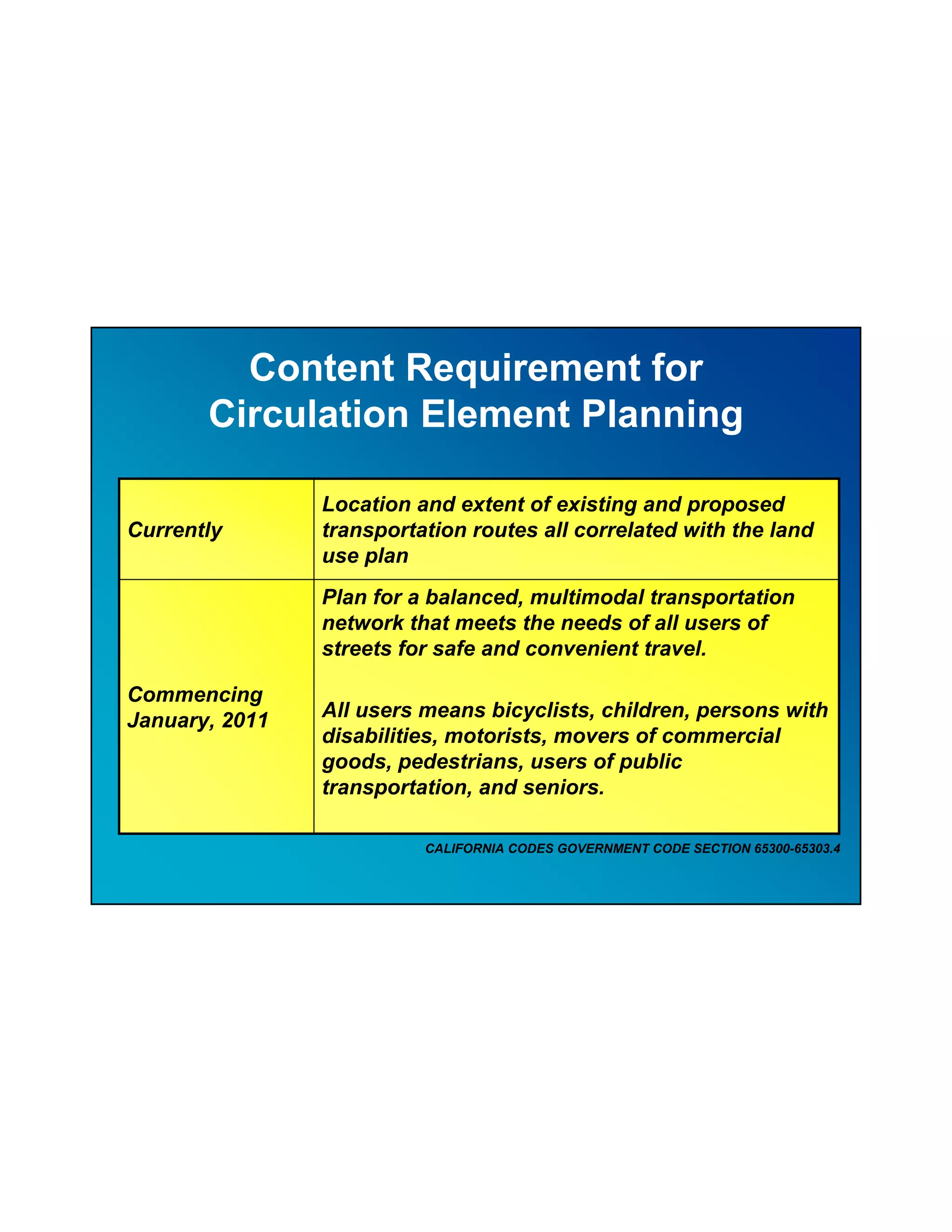
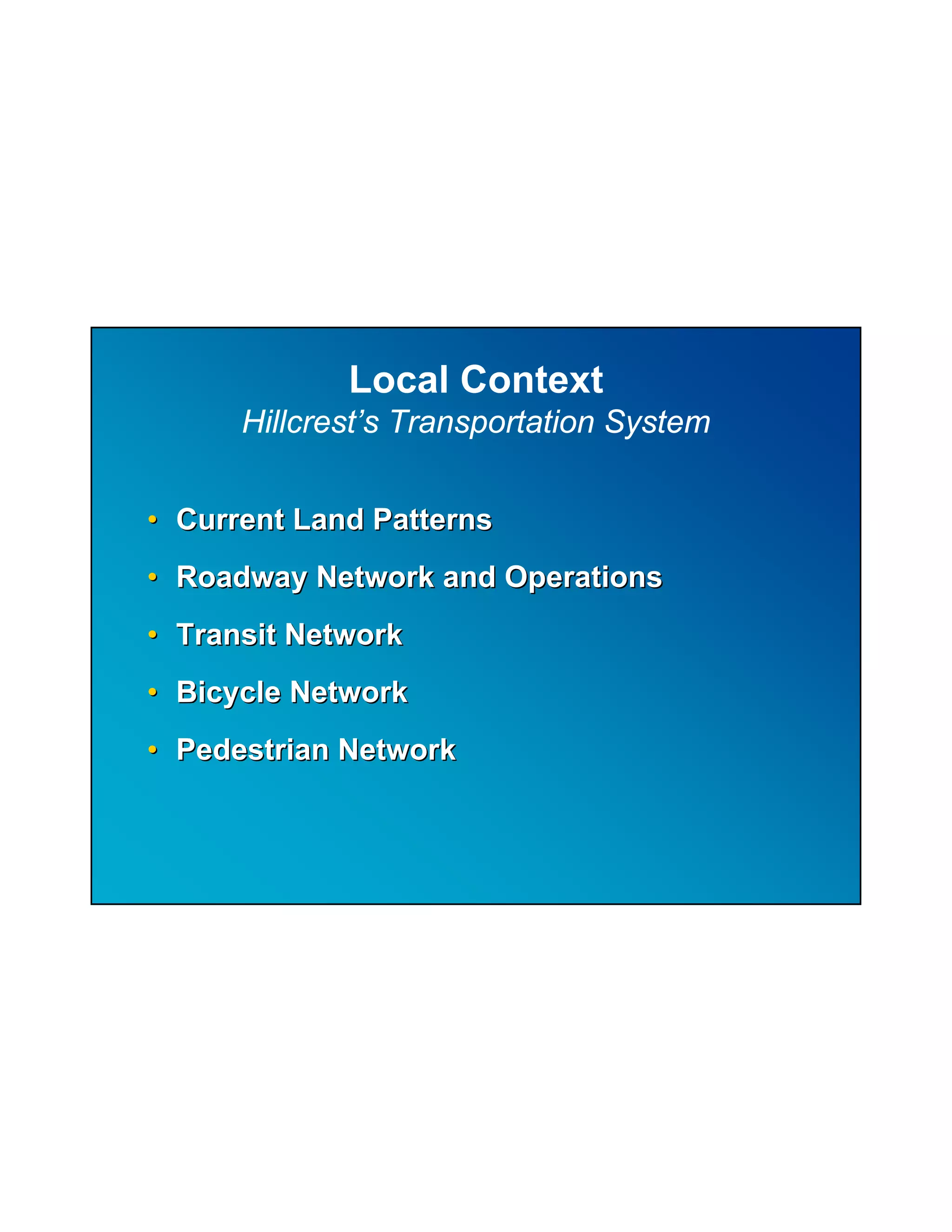
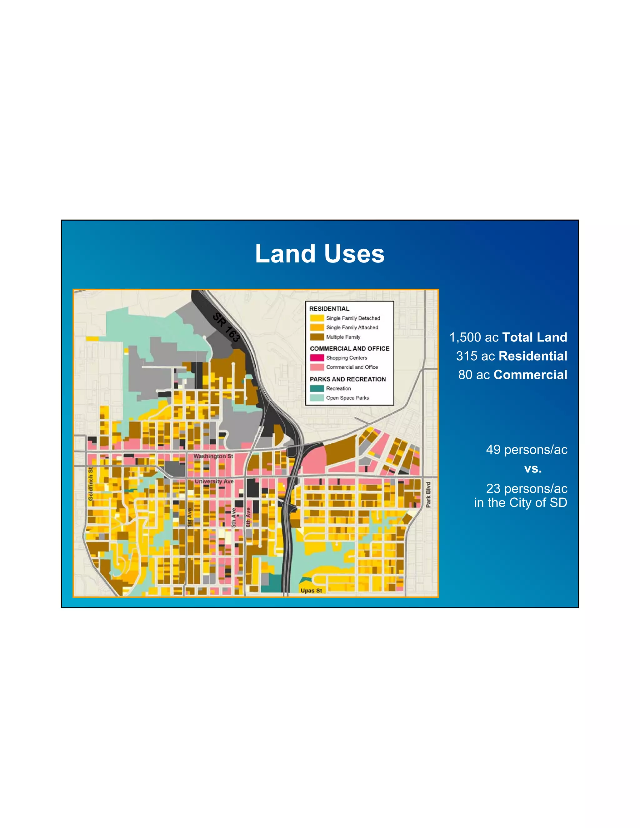
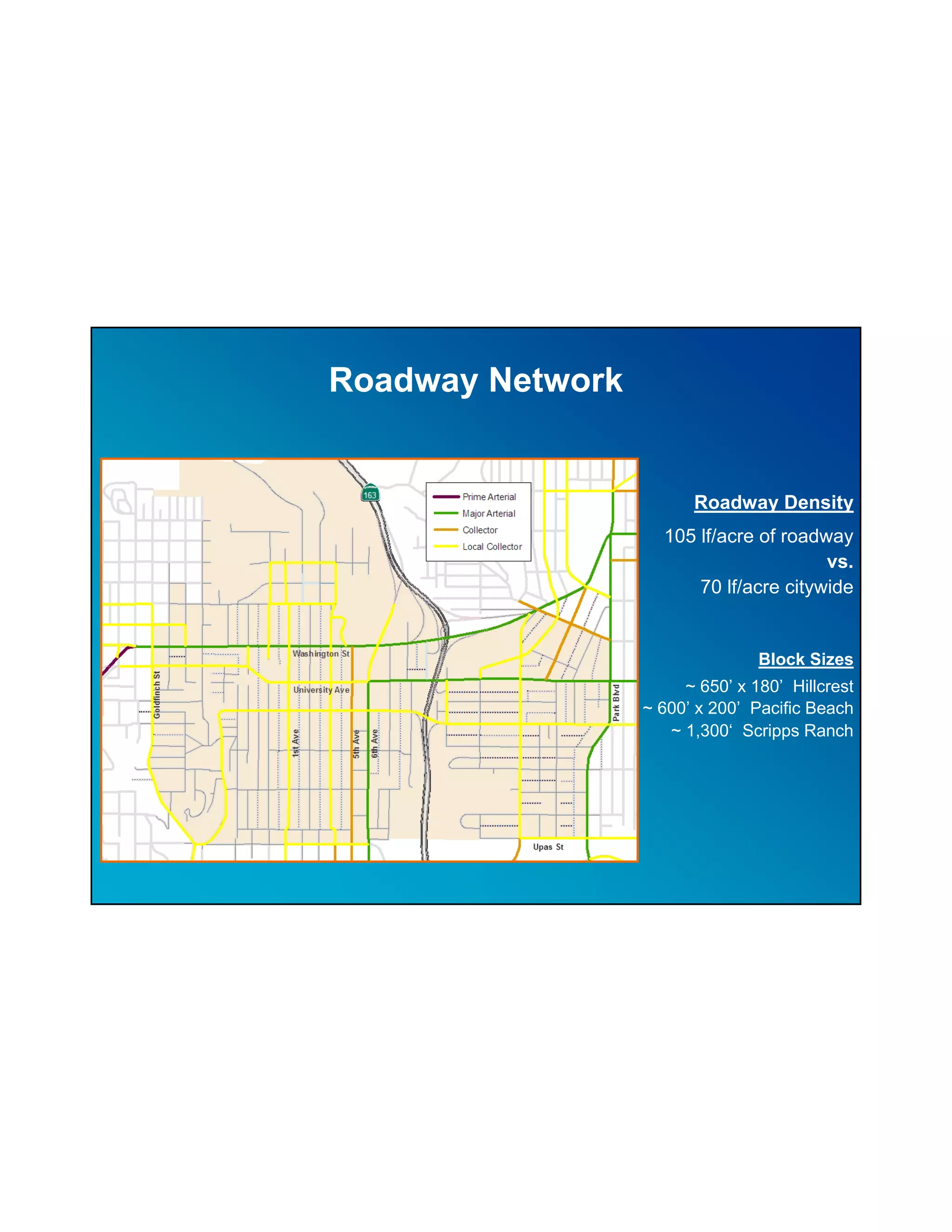
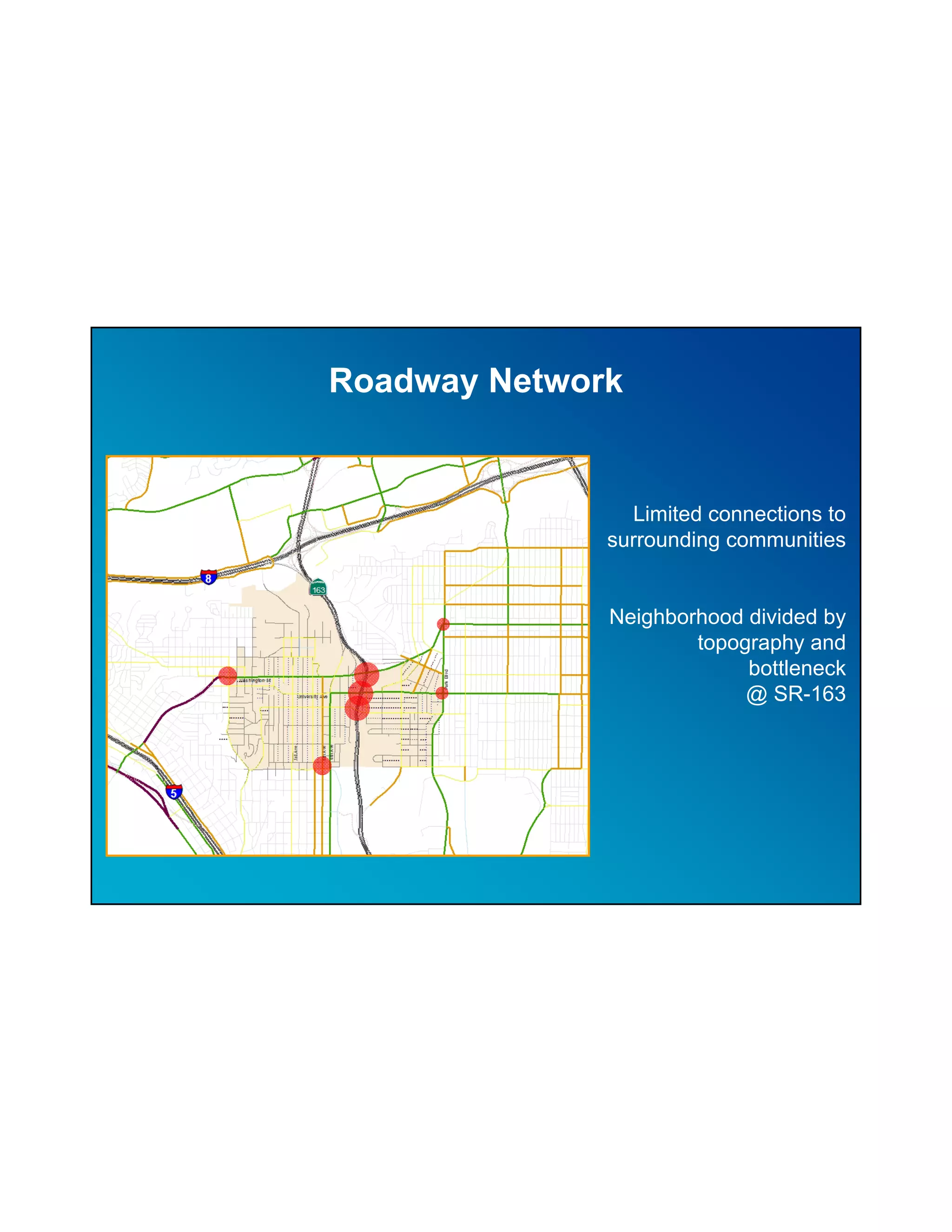
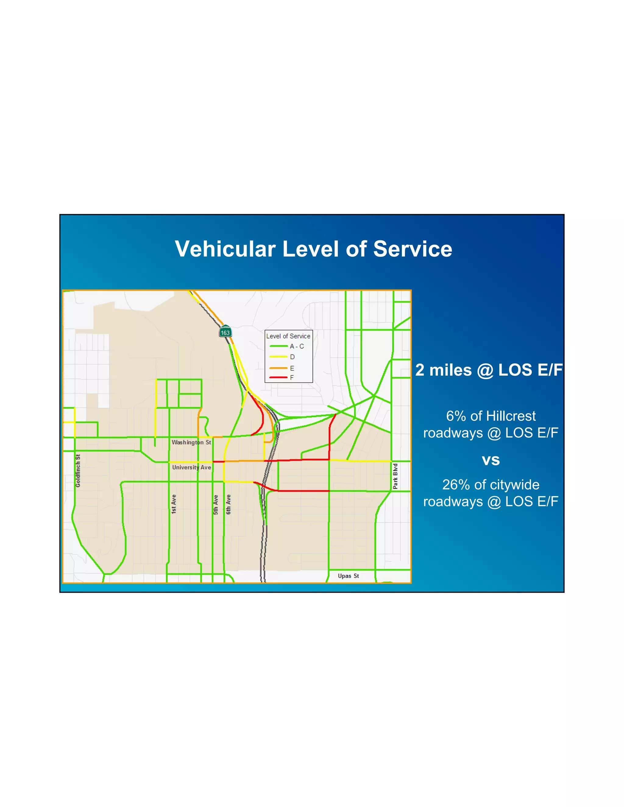
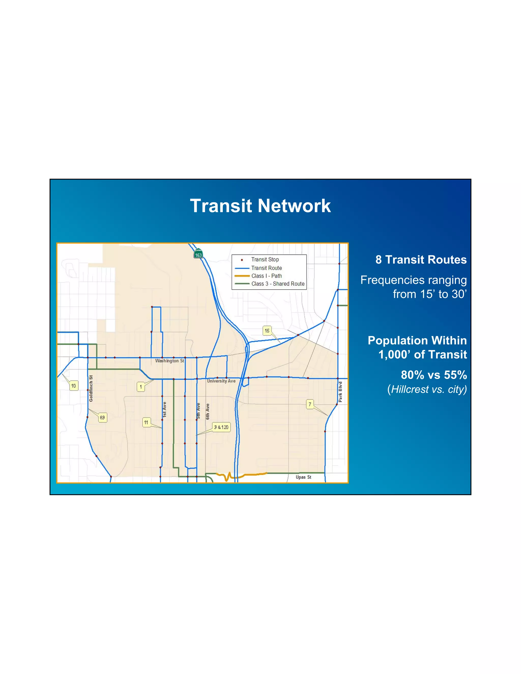
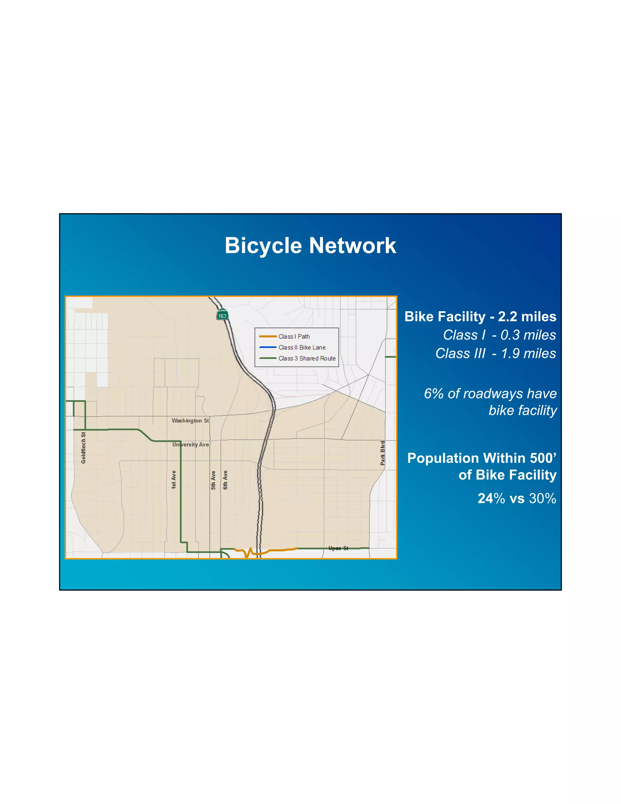
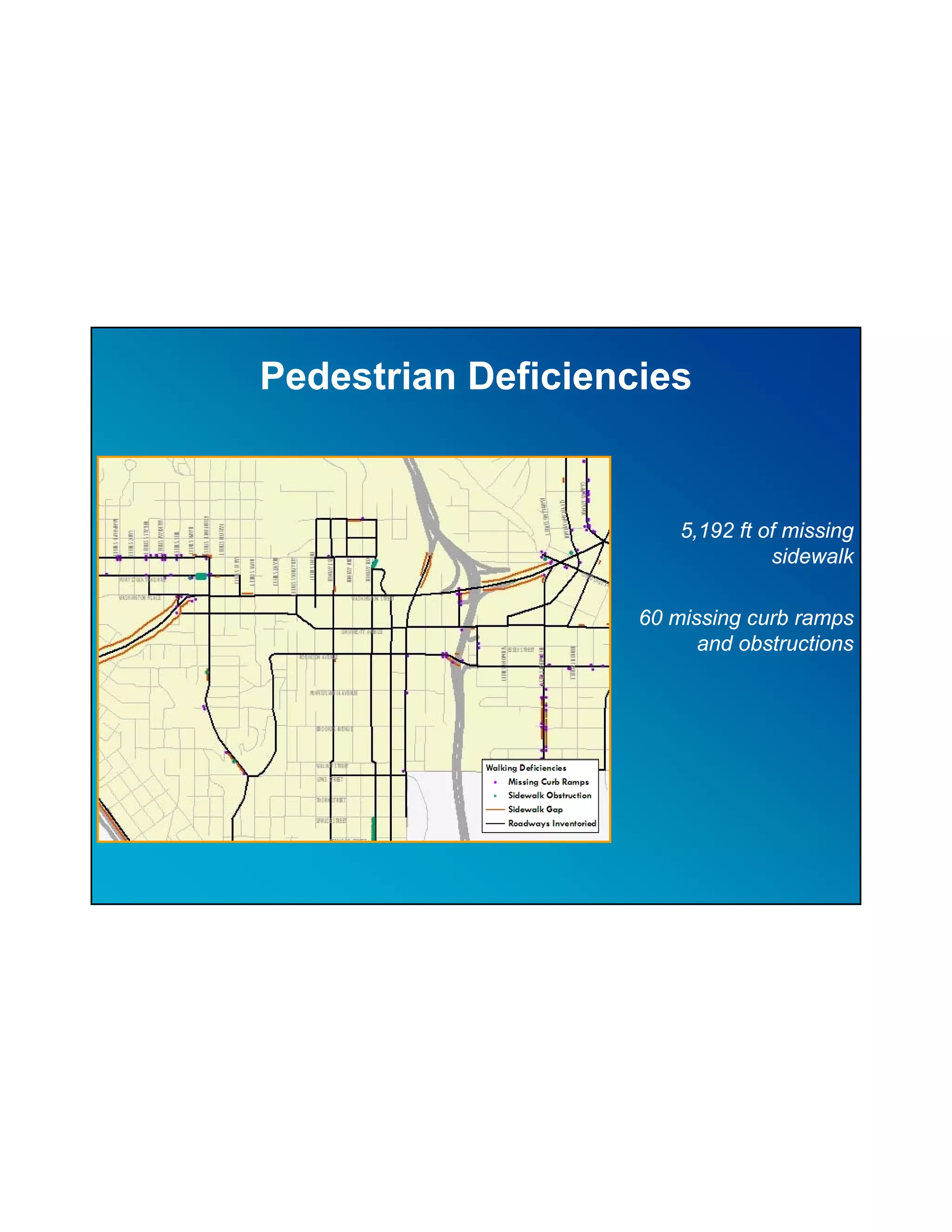
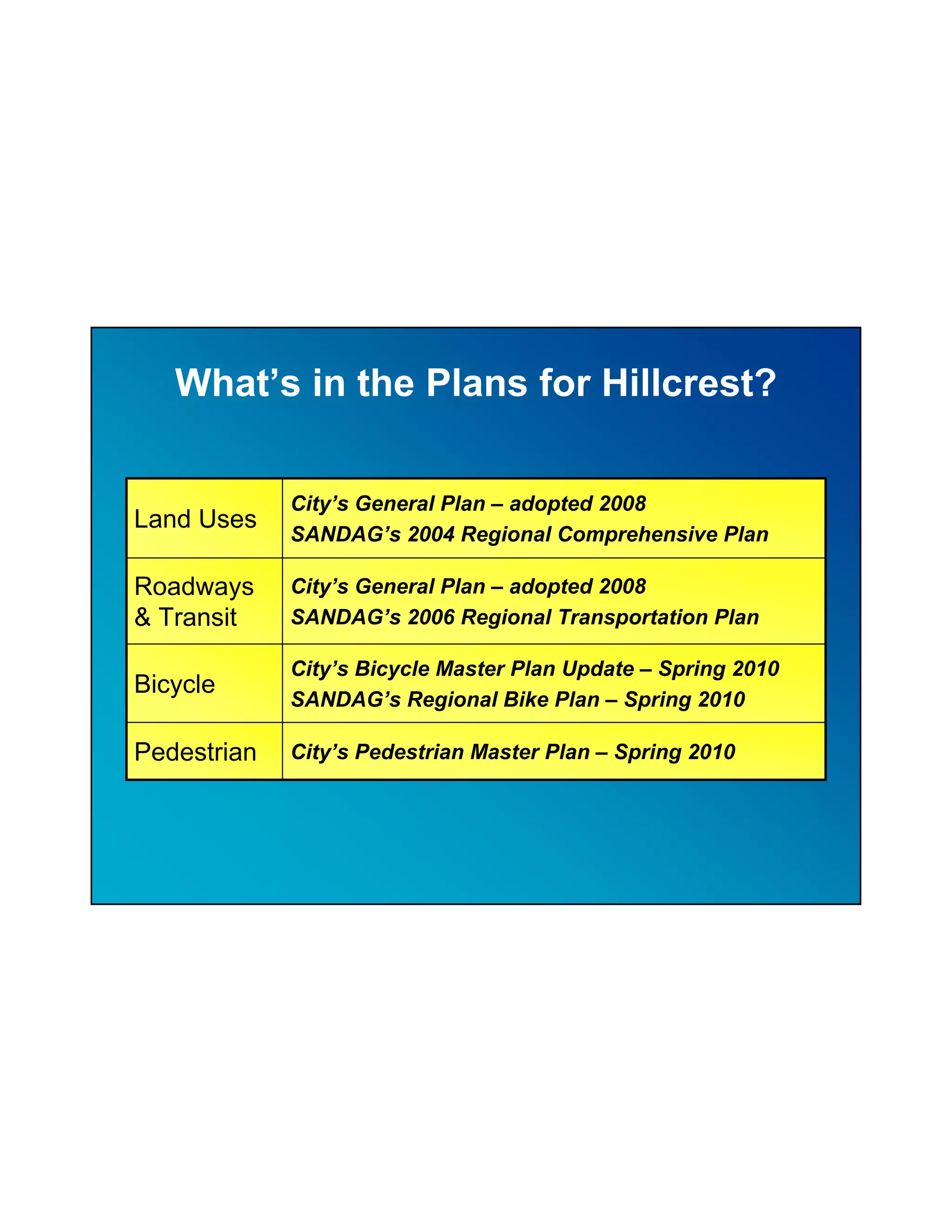
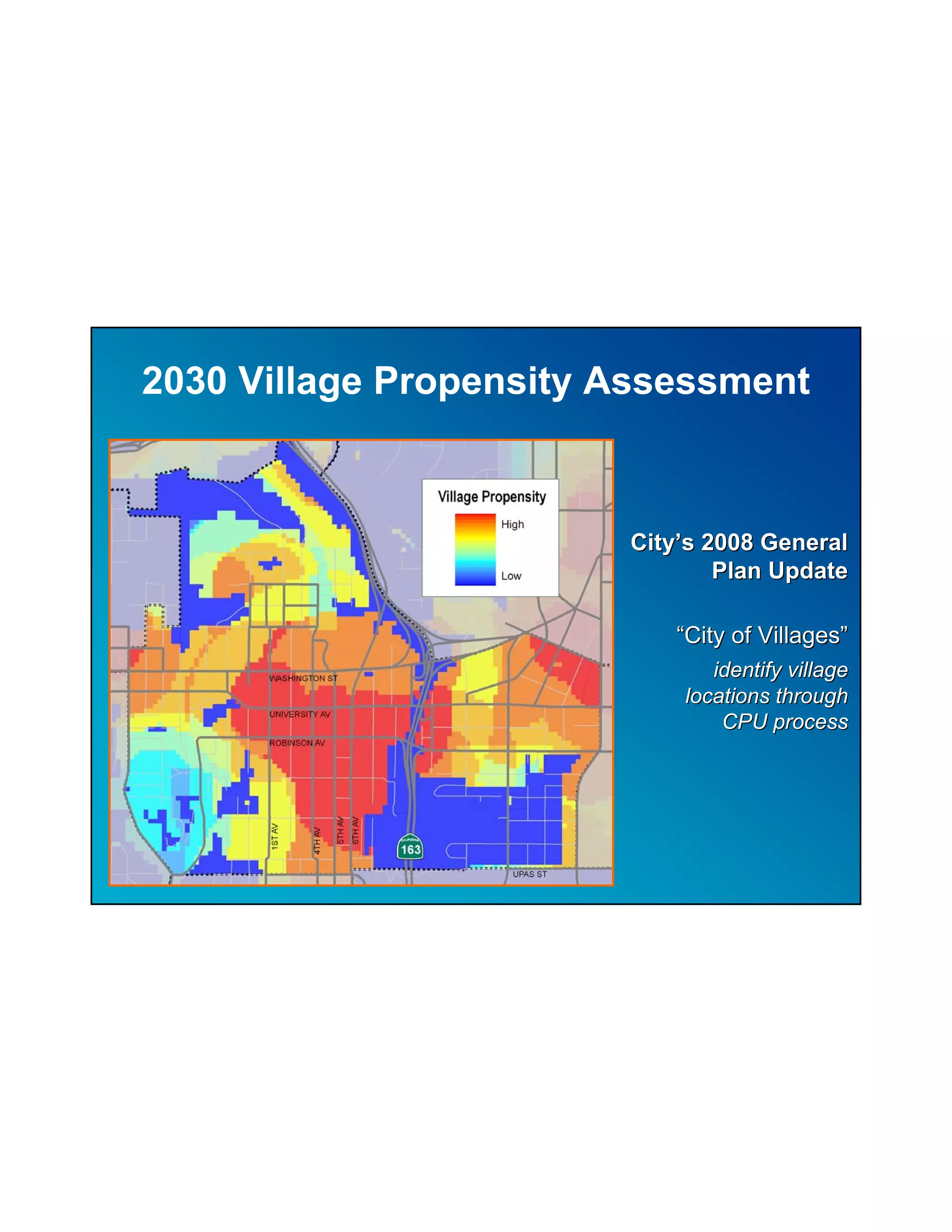
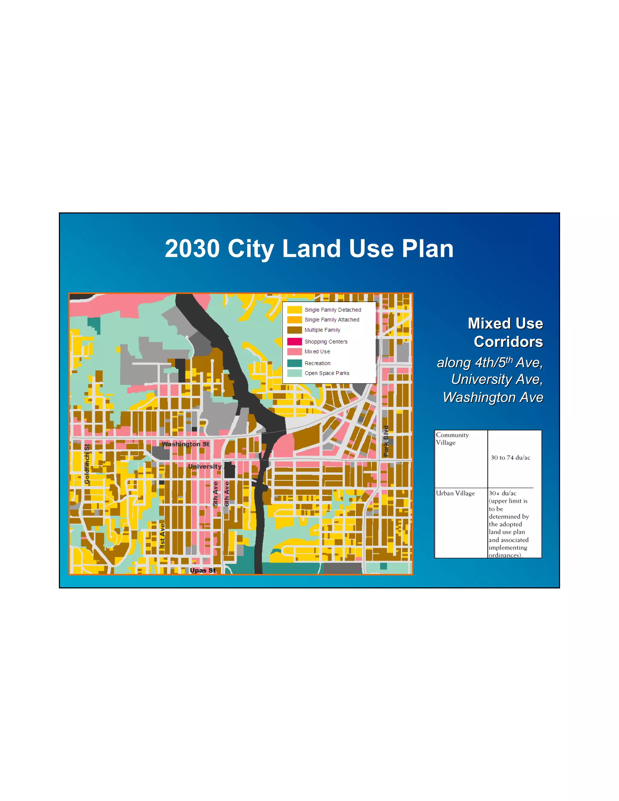
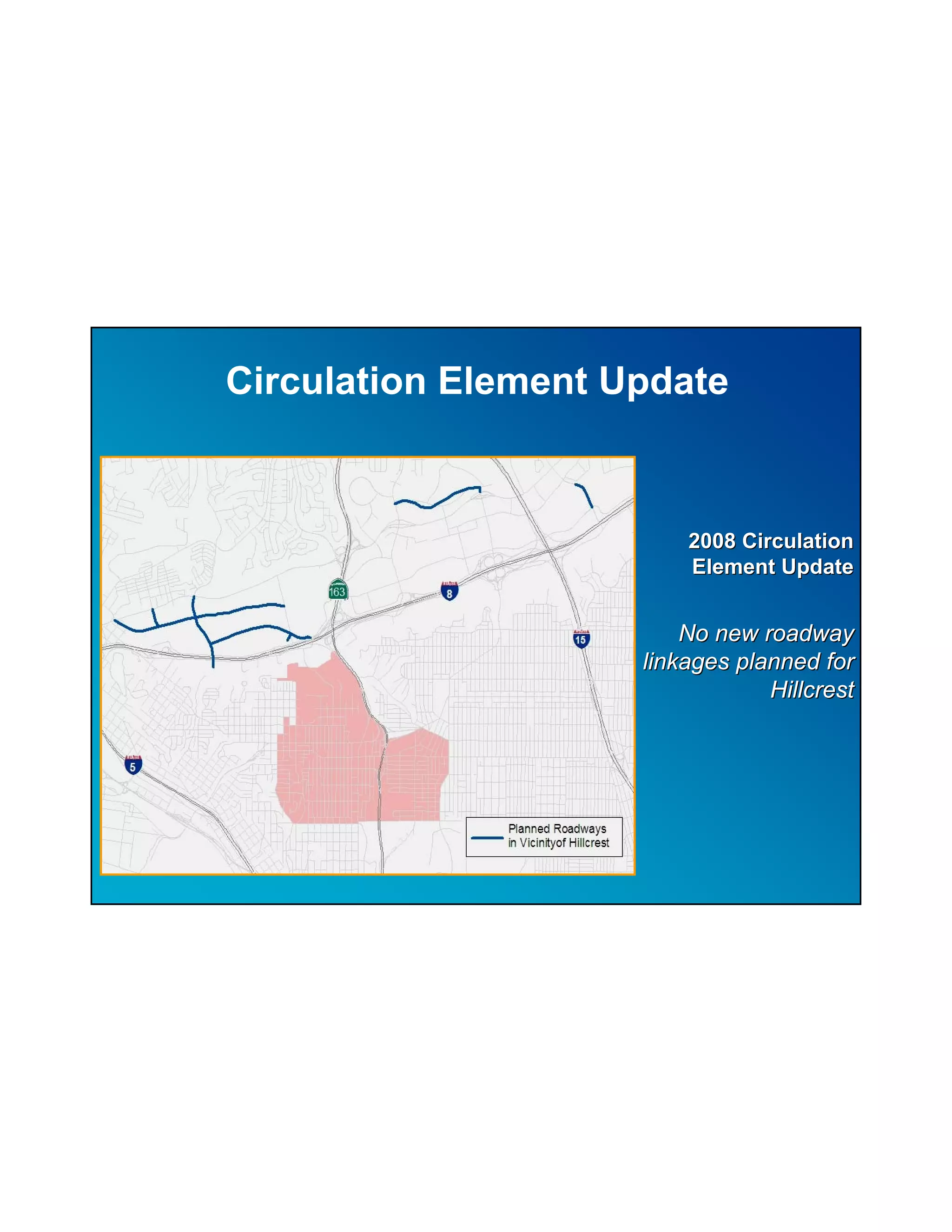
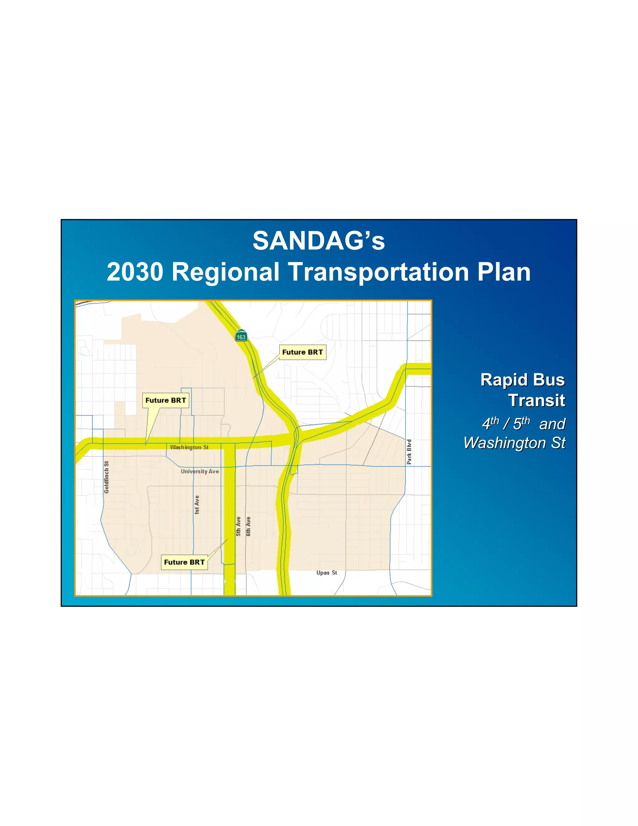
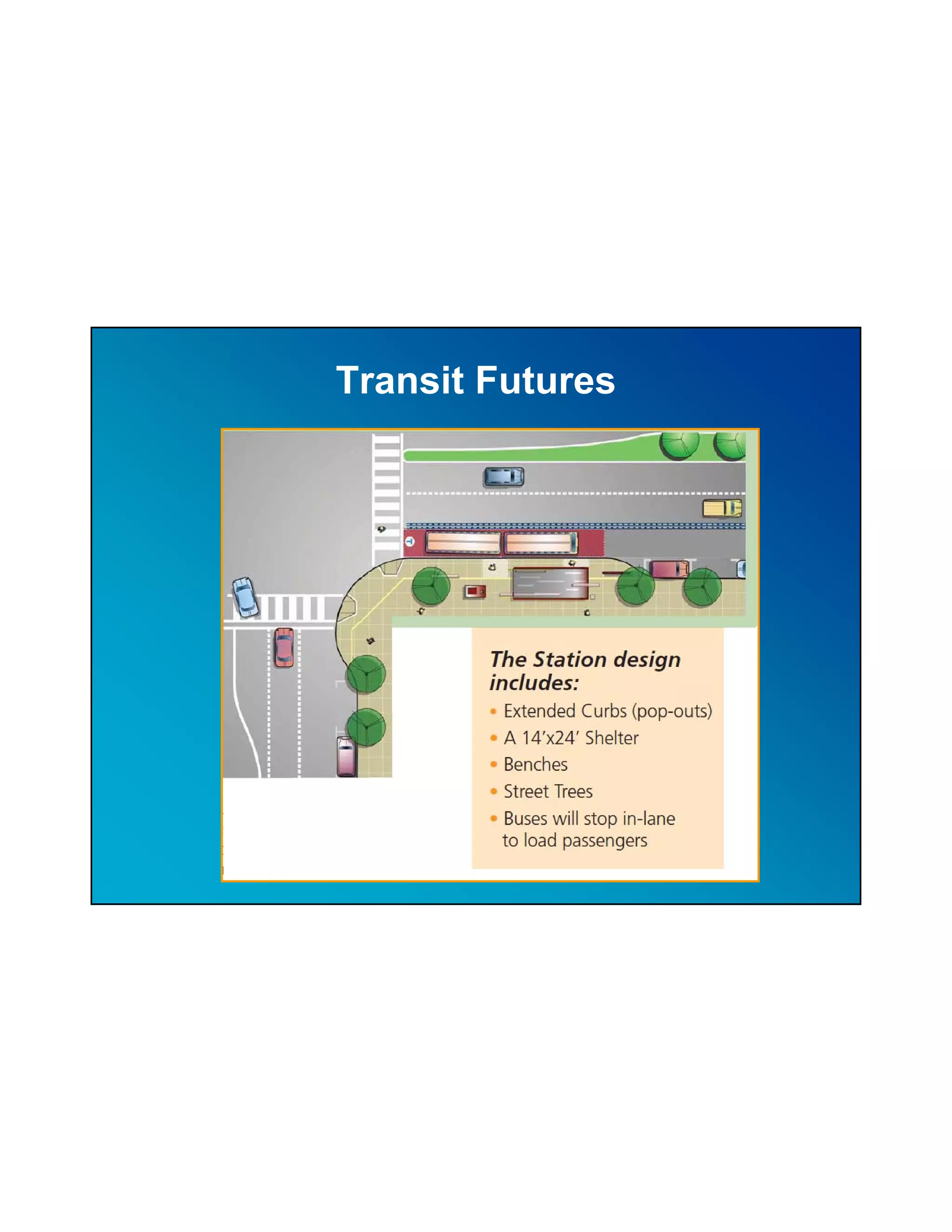
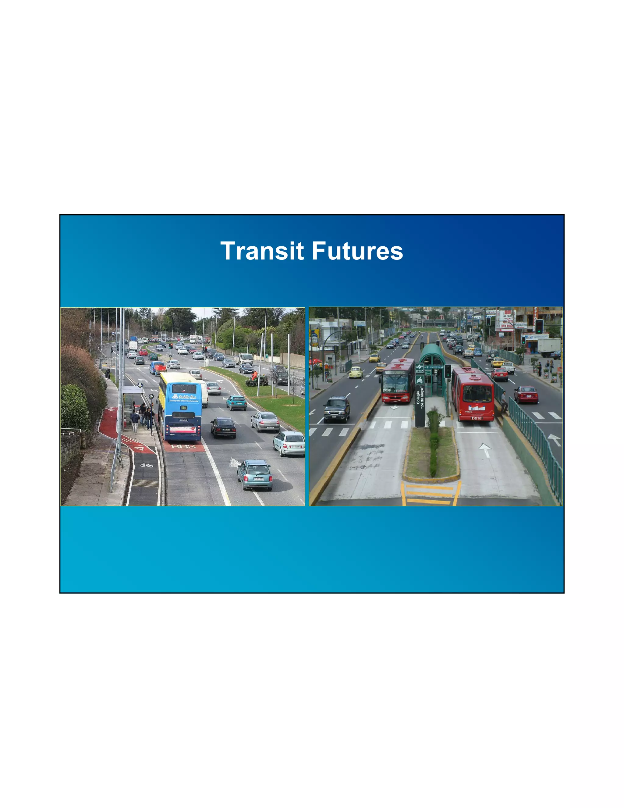
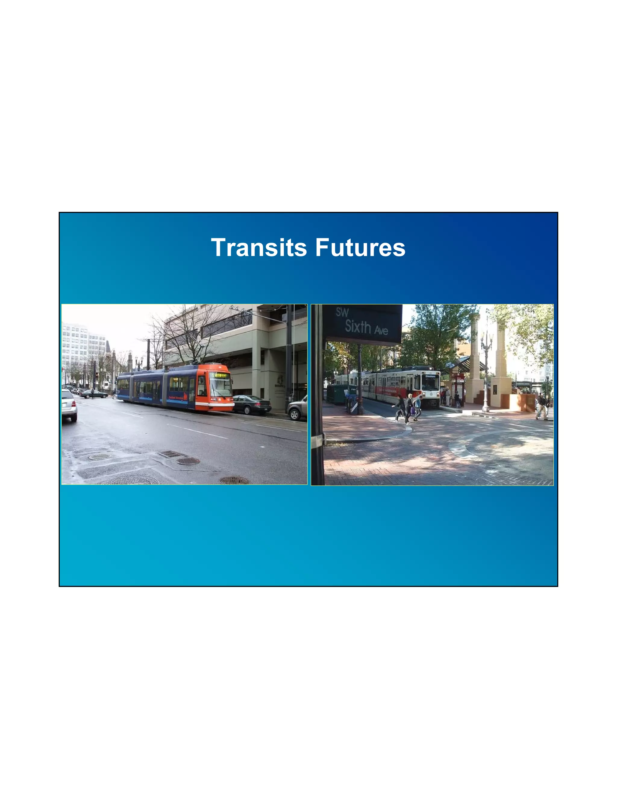
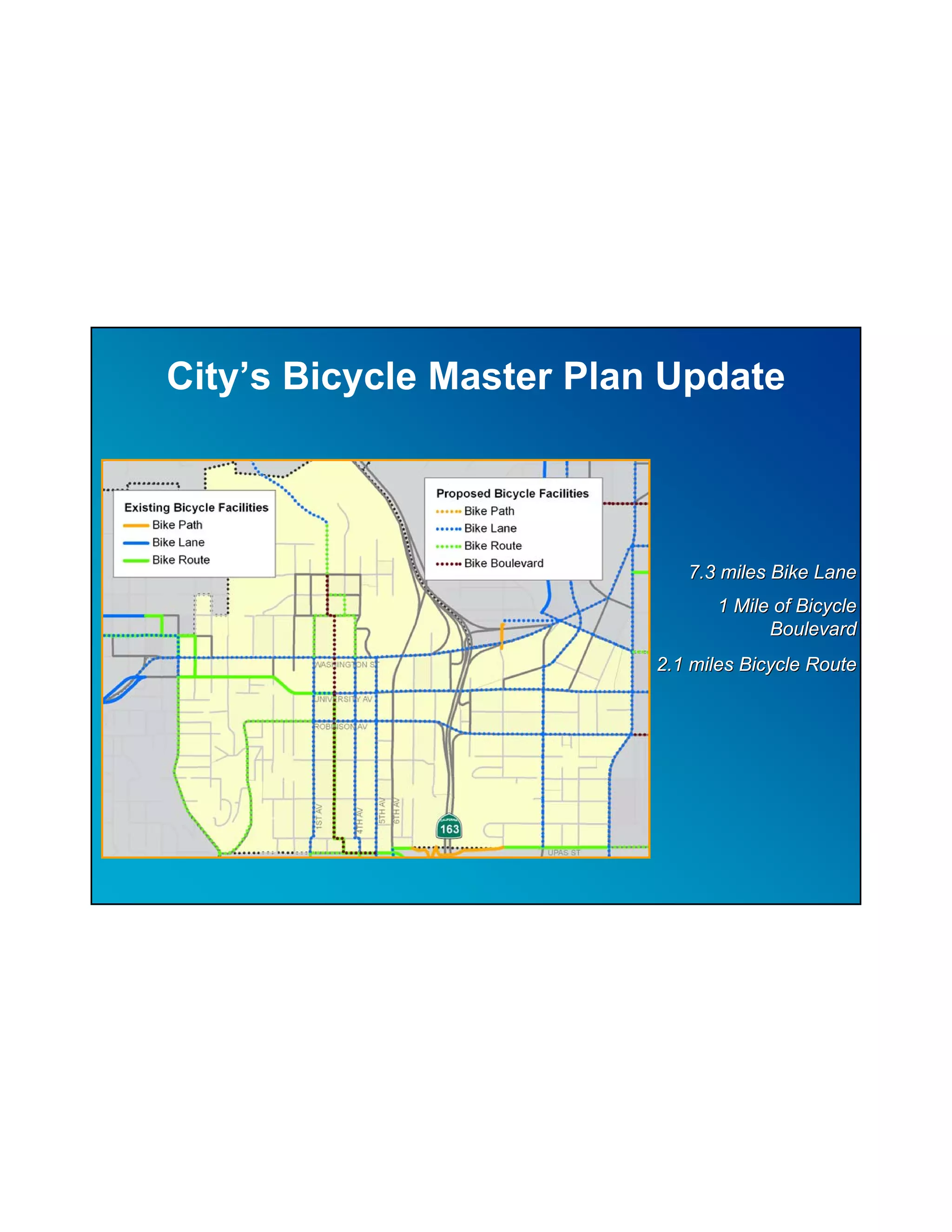
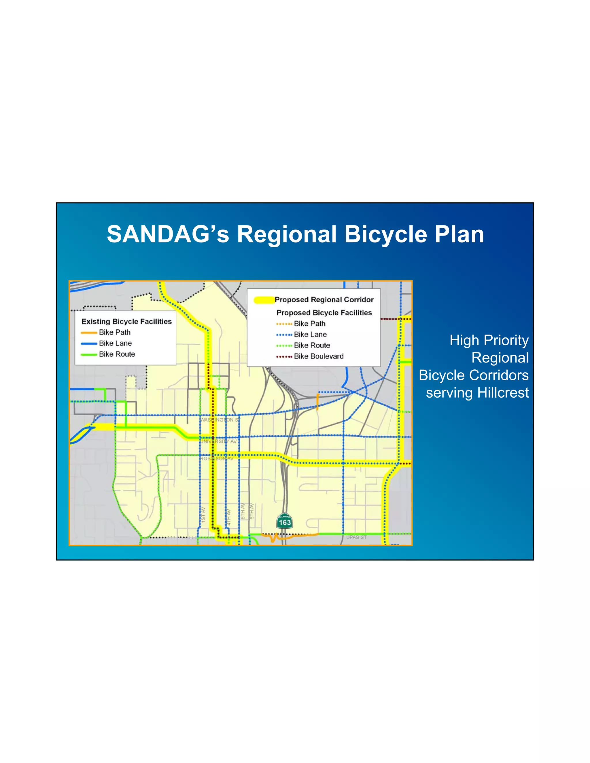
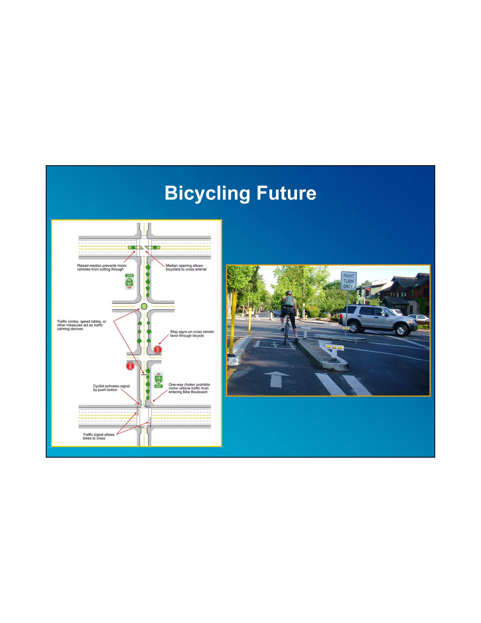
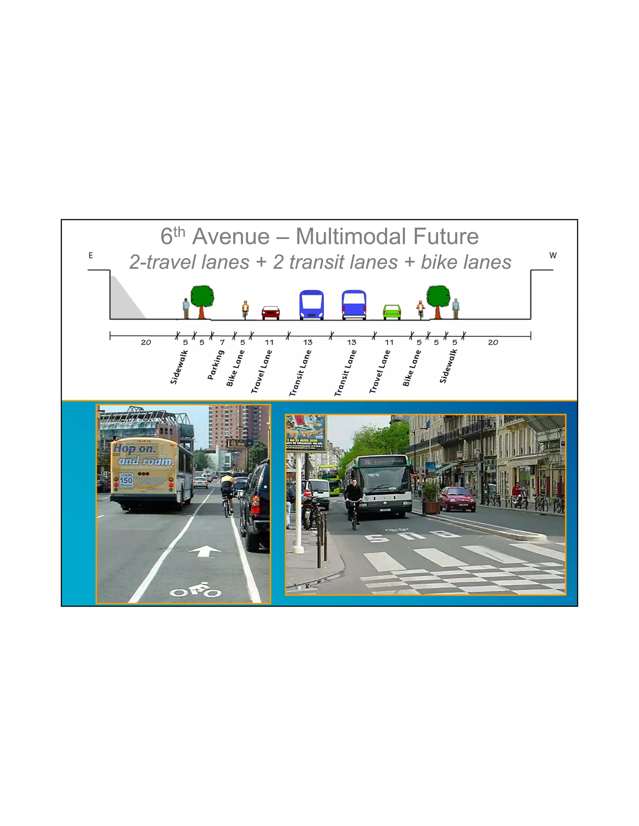
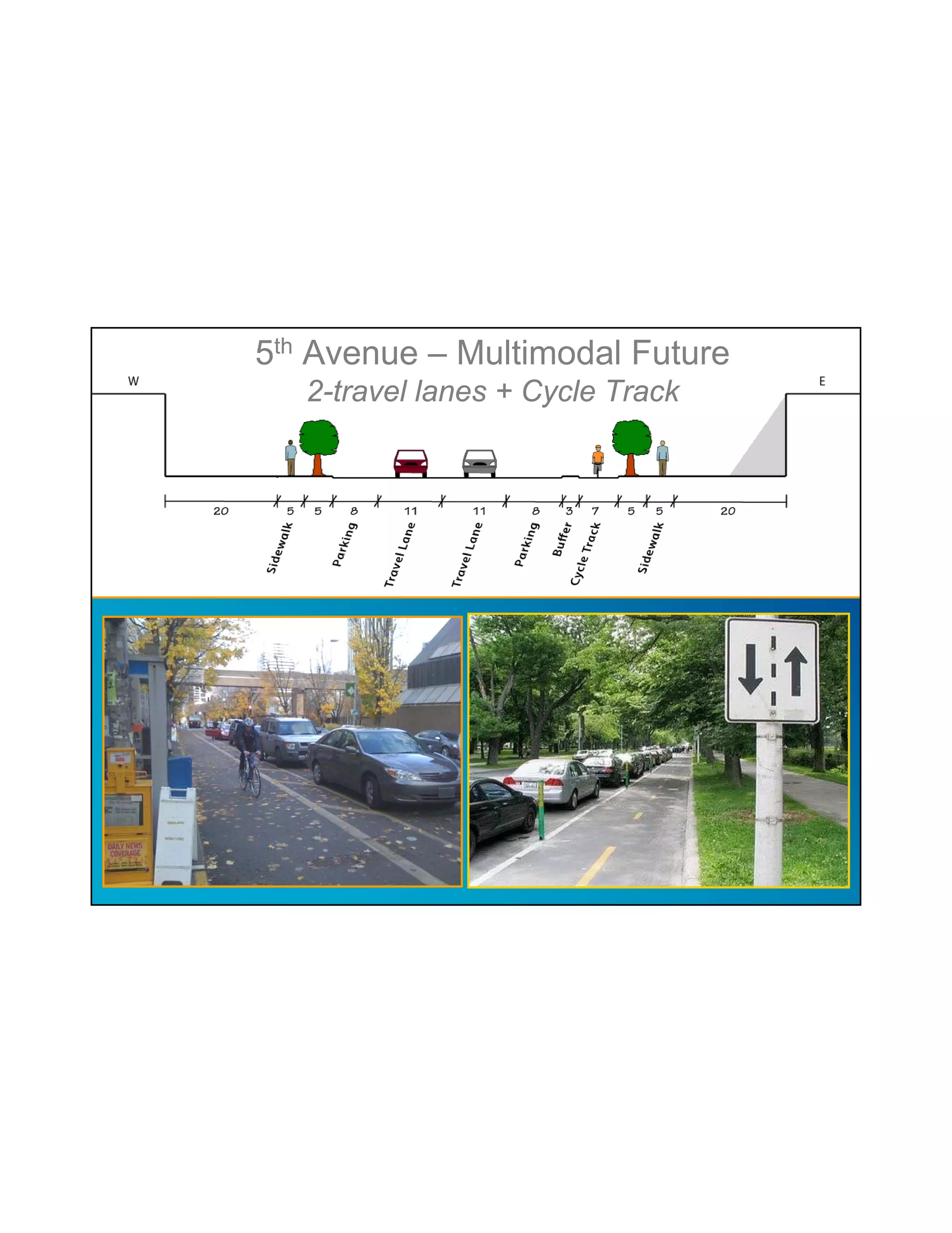
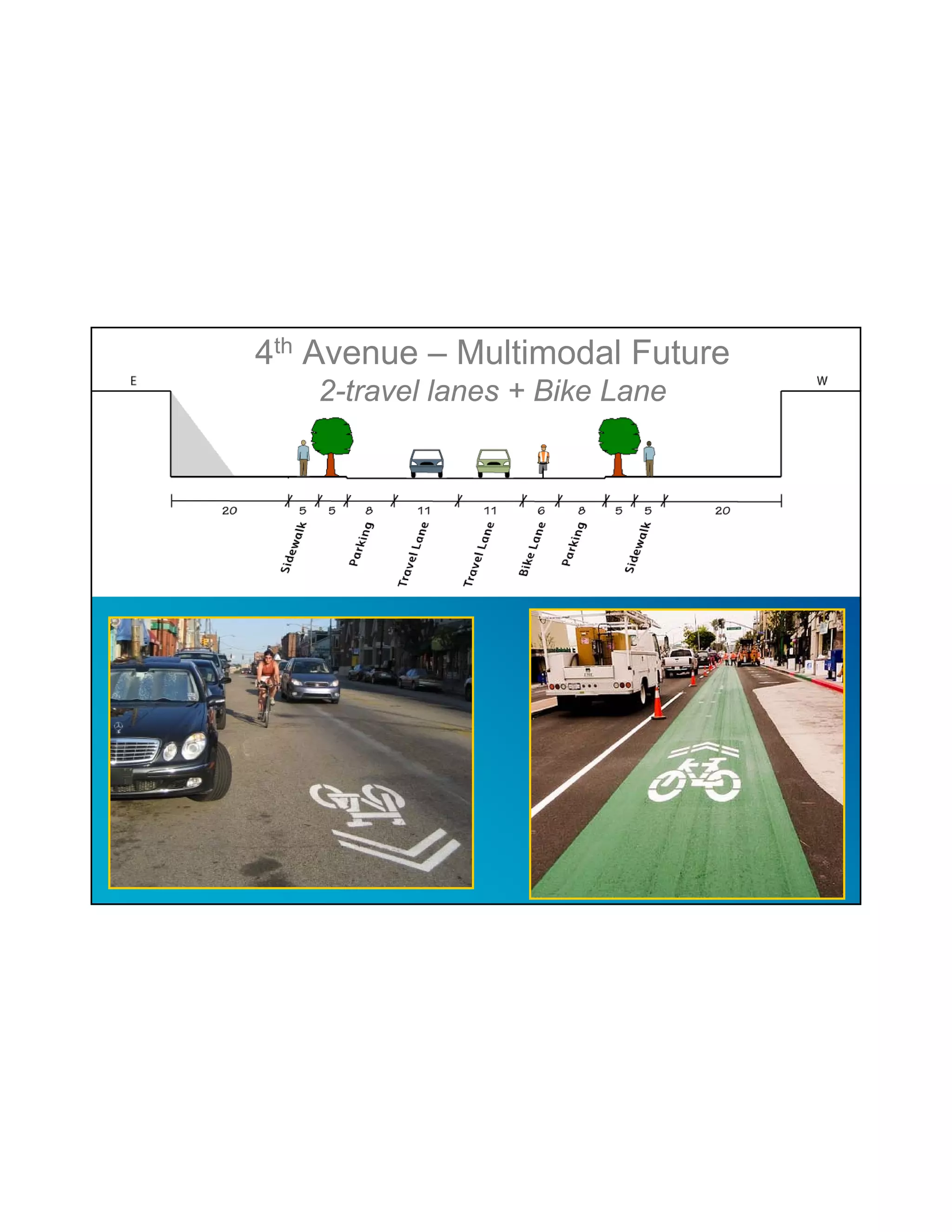
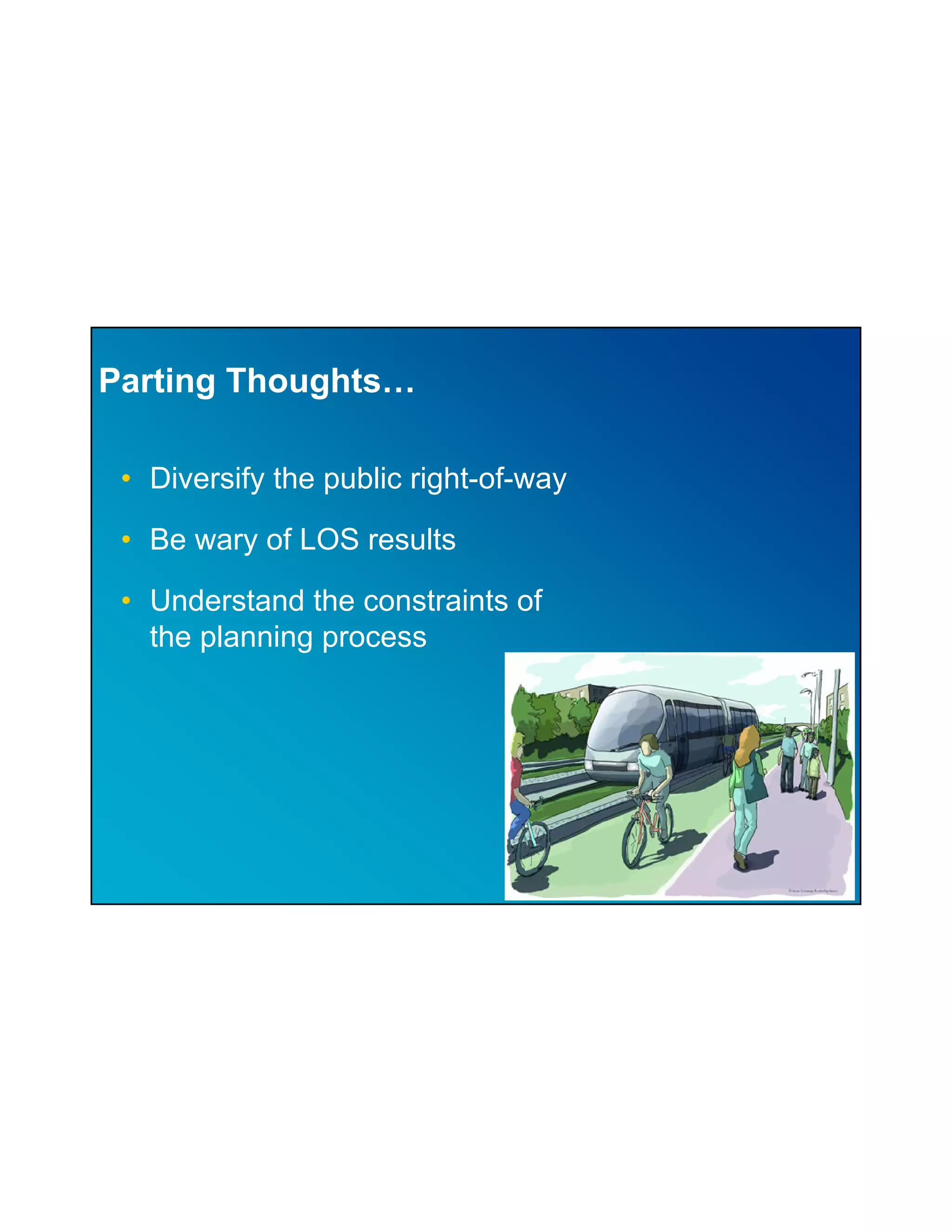
This document summarizes transportation planning for the Hillcrest neighborhood. It discusses the importance of long-range transportation planning, recent state legislation, and the current transportation context and plans for Hillcrest. The neighborhood currently has high roadway and transit access but limited bicycle and pedestrian infrastructure. Plans aim to diversify the transportation network and right-of-way to better accommodate all modes through measures like rapid bus transit, expanded bicycling facilities, and multimodal streets. Caution is urged around overreliance on level of service results and the constraints of the planning process.
2020 Karol Bagh Pedestrianization & Parking ManagementTOD India
The Pedestrianization and Parking Management project of Karol Bagh was approve by Governing Body of UTTIPEC in 2010 and initiated for implementation by North Delhi Municipal Corporation in 2019. The project was awarded as the best Non-Motorist Transport project by the Urban Mobility India in 2019.
The aim of this project was to improve the Mobility and accessibility of Karol Bagh and was planned in line with National Urban Transport Policy to prioritize mobility of people and encouragement of active modes. The project included improvement in pedestrian & NMT amenities and facilities, parking management, traffic management and circulation. The objectives of this project are:
• Prioritizing walking and other active modes (NMT, Rickshaw) and facilitating improved walking environment by providing comfortable and safe walking zone.
• Segregation of long term and short term parkers by creating off street and limited on street spaces
• Develop and organize on-street parking and off-street parking locations.
• Dynamic parking charges with costly on street parking and less costly differential off street parking to encourage long term parkers to use off street parking spaces.
• Provide public amenities such as public toilets, dustbins, benches etc.
• Revitalize the existing parks and integrate them with the shopping streets.
• Improve traffic circulation by creating one way loops and reducing conflicts at intersections. Improving pedestrian crossing facilities along streets, traffic calming facilities for safe movement.
• Organizing and managing spaces for hawkers
• Clear segregation of spaces with road marking.
• Improve wayfinding.
This presentation was given by COE Pune for "Samavesh" - XVl Annual NOSPlan Convention. The Theme of Presentation - "Accessibility in Peri-urban area".
RV 2015: Learn, Ask and Do: The Corridor Game Take 2 by James HenckeRail~Volution
Learn about corridor planning across the country. Ask questions. Then build your own corridor! Hear how planners struggle to accommodate multiple transportation modes (bus, BRT, light rail, auto, freight, bike, pedestrian) within a limited right of way. Review case studies from San Francisco, San Antonio and Portland. Study the tradeoffs inherent in different cross-section treatments and strategies for prioritizing design to respond to planning goals and land use context. Then put everything you've learned to work as you design your own multimodal corridors to solve for different planning problems. Easier said than done, but an active and humbling learning experience.
Moderator: James Hencke, ASLA, LEED AP, Senior Landscape Architect, David Evans and Associates, Inc, Portland, Oregon
Elizabeth Mros-O'Hara, AICP, Investment Areas Project Manager, Regional Principal Planner, Metro, Portland, Oregon
Kelly Betteridge, Planning Manager, TriMet, Portland, Oregon
Aaron Carter, Manager, ICF International, San Francisco, California
Arturo Herrera, Senior Service Planner, VIA Metropolitan Transit Authority, San Antonio, Texas
Presentation at TOD training program by ADB - covering TOD basics, 5 TOD principles, What is TOD, Sustainability, Delhi, Bangaluru, ADB, ADB training, National TOD Policy, Pedestrian, Walkability, NMT, Non motorized transport, Women Safety, Setbacks, Women friendly environment, women oriented urban design, urban design, urban planning, Street safety, natural surveillance, Connectivity, Network planning, Pedshed analysis, multimodal integration, Form Based Codes, DDA, IRSDC, MOHUA, Ministry of Housing and Urban Affairs, Railways, Delhi Development Authority, Karol Bagh, Ajmal Khan, Pedestrianization, Affordable Housing, Karkadooma, Recycling, Daylighting, Energy modeling
This presentation gives an introduction to transportation planning. It talks about what is transportation and its need. It also talks about how transportation has evolved over the period of time and how the city structure and people's behavior changes with it.
This presentation talks about the basics of transportation planning. The transportation jargons that are used like ROW, Carriage way etc. It also talks about the Road hierarchy, Intersections, Road Capacity and Level of Service.
Transport planning for Sydney is based on continuing the past and yet simple examination shows this calls for a impossible future. Fundamental change is called for and planning for it must start now.
On May 20, 2010, Mary Raulerson of Kittelson & Associates held a workshop in Portland, OR which introduced and illustrated best practices in the field of Complete Streets using case studies she has been directly involved with around the country. During the workshop, special attention was given to the obstacles that had to be overcome and the solutions that worked. The goal of this session was to help identify and tailor practices that will further strengthen the region’s move toward creating, connecting and complimenting great places with great multimodal rights-of-way.
Presented at the Royal Geographical Society (RGS) Annual International Conference, 27-29 August 2014.
www.rgs.org/WhatsOn/ConferencesAndSeminars/Annual+International+Conference/Annual+international+conference.htm
Accessibility in an Urban Area: Alcântara, Lisboa, Presentation part 2Luis Neto
Gestão da Mobilidade Urbana, Mestrado de Planeamento e Operação de Transportes. Instituto Superior Téncico, Universidade de Lisboa, Nota do Trabalho 18 / 20. Nota final 17 / 20.
Urban Mobility Management, MSc Transport Planning and Operation, Instituto Superior Tecnico, Lisbon University. Project course grade 18 / 20. Final grade 17 / 20
Summary of the health impact assessment led by Natalie Mueller, an ISGlobal researcher, on urban and transport planning related exposures and mortality.
This presentation was prepared for an event organized by the Pla Estratègic Metropolità de Barcelona on February 10th 2017.
We focus on the challenge of creating attractive ‘places’ when we (as professionals) are so pre-occupied with getting ‘through space’. Presentation was given by Colin Black and John Dales in 2006 at the European Transport Conference. Virtually all of what we were saying then still holds true for planning, urban design and transport today. The application of learning sure takes time!
During the 2017 National Regional Transportation Conference, Dan Blankenship shared information about the Roaring Forks Transportation Authority's work to serve the mobility needs of the region, including through bus rapid transit and other innovations.
RV 2014: Complete Streets- From Policy to Implementation by James Cromar and ...Rail~Volution
Complete Streets: From Policy to Implementation (Completely) AICP CM 2
2 HOUR SESSION
How can you make your complete streets policy a success? How do you translate complete streets into real benefits for the people who are walking, biking and taking public transportation? How do you promote accessibility and connectivity for all -- including people with disabilities -- through design and planning? Hear regional, city and international perspectives from policy to implementation during this complete complete streets workshop.
Moderator: Richard Weaver, AICP, Director of Planning, Policy and Sustainability, American Public Transportation Association; Chair, National Complete Streets Coalition, Washington, DC
Joseph Iacobucci, Sam Schwartz Engineering, DPC, Chicago, Illinois
Stefanie Seskin, Deputy Director, National Complete Streets Coalition, Smart Growth America, Washington, DC
Dan Gallagher, AICP, Transportation Planning Manager, Charlotte Department of Transportation, Charlotte, North Carolina
James Cromar, Director of Planning, Broward Metropolitan Planning Organization, Ft. Lauderdale, Florida
Tony Hull, Independent Transportation Consultant, Minneapolis, Minnesota
Gregory Thompson, Chair, Light Rail Transit Committee of TRB, Tallahassee, Florida
Roxana Ene, Project Manager, Broward Metropolitan Planning Organization, Ft. Lauderdale, Florida
In 2017-8, Michael Burrill forwarded his ideas on how cities can encourage Smart Growth and fund regional rail transit lines - without raising taxes - to public officials and interested citizens in several cities. Attached are his latest slides that use tax revenues from Transit-Oriented-Development (TOD) in Cincinnati as an example. Most other regions can anticipate similar results - with revenues from TOD at least five to 20 times the cost of new light rail lines.
TOWNSHIP OF LANGLEY/PROVINCIAL, REGIONAL AND LOCAL TRANSPORTATION PLANS AND S...South Fraser Blog
Presentation by Paul Cordeiro, Manager of Transportation Engineering for the Township of Langley. The slides show an overview of the South of Fraser Transit Plan, Provincial Transit Plan, Provincial Gateway Program, Roberts Bank Rail Corridor Study, Community Rail Study, and the Township of Langley’s Master Transportation Plan.
On March 2015, the City of Summit initiated a Feasibility Study on the vision of converting the abandoned Rahway Valley Railroad into a rail trail more commonly referred to as the Summit Parkline. The Study develops feasible and economical concepts for a 1.2-mile trail and linear park on the existing railroad right-of-way. The Summit Parkline is a unique opportunity for the City to create a recreational amenity that has potential to be a major local and regional attraction and character-giving symbol for the community.
Transport Policies for Van Couver, CanadaSaumya Gupta
The presentation covers the Transport Policies of Vancouver. All data is from secondary sources, which are duly mentioned in the last slide. This was done as a part of an assignment of Transport Policy and Legislation.
Presentation tries to portray the context, necessity, role and importance of transportation in the urban context, issues faced by cities in rationalizing transport and options which can be leveraged in making transportation sustainable - which inter alia includes; making cities compact, planning for people, promoting accessibility, limiting mobility, re-ordering the priority for mobility, leveraging mass transportation, technology etc. Presentation stresses the role an d importance of shape and size of the city in making transportation sustainable. Need for changing the approach to urban planning has also been emphasized.
NEPA and Permitting 101: A Dialogue on the Basicsnado-web
During the 2019 NADO Annual Training Conference (October 19 - 22 in Reno, NV), Rob Hyman shares information on the basics of federal environmental reviews and permits required by the National Environmental Policy Act.
RV 2014: Complete Streets- From Policy to Implementation by Dan GallagherRail~Volution
Complete Streets: From Policy to Implementation (Completely)
How can you make your complete streets policy a success? How do you translate complete streets into real benefits for the people who are walking, biking and taking public transportation? How do you promote accessibility and connectivity for all -- including people with disabilities -- through design and planning? Hear regional, city and international perspectives from policy to implementation during this complete complete streets workshop.
Moderator: Richard Weaver, AICP, Director of Planning, Policy and Sustainability, American Public Transportation Association; Chair, National Complete Streets Coalition, Washington, DC
Joseph Iacobucci, Sam Schwartz Engineering, DPC, Chicago, Illinois
Stefanie Seskin, Deputy Director, National Complete Streets Coalition, Smart Growth America, Washington, DC
Dan Gallagher, AICP, Transportation Planning Manager, Charlotte Department of Transportation, Charlotte, North Carolina
James Cromar, Director of Planning, Broward Metropolitan Planning Organization, Ft. Lauderdale, Florida
Tony Hull, Independent Transportation Consultant, Minneapolis, Minnesota
Gregory Thompson, Chair, Light Rail Transit Committee of TRB, Tallahassee, Florida
Roxana Ene, Project Manager, Broward Metropolitan Planning Organization, Ft. Lauderdale, Florida
Presentation by Rick Hall, PE at Great Streets-Healthy Communities program hosted by ULI Memphis and the University of Memphis Partnership for Active Community Environments in Memphis, TN on April 21, 2010.
Rural Road Safety: Addressing Bicyclist & Pedestrian ChallengesRPO America
During the 3rd Annual National Summit on Rural Road Safety, NADO Associate Director Carrie Kissel participated in a panel on improving safety outcomes for vulnerable populations. Kissel's presentation focused on bicycle and pedestrian safety.
2. Overview
• Why Long Range Transportation Planning?
• Recent Legislation
• Local Hillcrest Context
• Current Planning for Hillcrest
• Potential Futures
3. Why Long Range
Transportation Planning?
• Mandated by Federal and State Governments
– Metropolitan Planning Organizations must do long range
transportation planning to receive federal funds
– Cities must adopt Circulation Elements
• Provides objective basis for decision-making
4. Recent Legislative Trends
• Sustainable Communities Strategy (2008 SB 375 )
– Sustainable Communities Strategies element in RTP
– Region must meet greenhouse gas reduction targets
– Housing allocations need to be consistent with SCS
• The Complete Streets Act (2008 SB 1358 )
– Requires cities to account for all users of the roadway when
updating their Circulation Elements
5. Content Requirement for
Circulation Element Planning
Location and extent of existing and proposed
Currently transportation routes all correlated with the land
use plan
Plan for a balanced, multimodal transportation
network that meets the needs of all users of
streets for safe and convenient travel.
Commencing
January, 2011 All users means bicyclists, children, persons with
disabilities, motorists, movers of commercial
goods, pedestrians, users of public
transportation, and seniors.
CALIFORNIA CODES GOVERNMENT CODE SECTION 65300-65303.4
6. Local Context
Hillcrest’s Transportation System
• Current Land Patterns
• Roadway Network and Operations
• Transit Network
• Bicycle Network
• Pedestrian Network
7. Land Uses
SR
16
1,500 ac Total Land
3
315 ac Residential
80 ac Commercial
49 persons/ac
vs.
23 persons/ac
in the City of SD
8. Roadway Network
Roadway Density
105 lf/acre of roadway
vs.
70 lf/acre citywide
Block Sizes
~ 650’ x 180’ Hillcrest
~ 600’ x 200’ Pacific Beach
~ 1,300‘ Scripps Ranch
9. Roadway Network
Limited connections to
surrounding communities
Neighborhood divided by
topography and
bottleneck
@ SR-163
10. Vehicular Level of Service
2 miles @ LOS E/F
6% of Hillcrest
roadways @ LOS E/F
vs
26% of citywide
roadways @ LOS E/F
11. Transit Network
8 Transit Routes
Frequencies ranging
from 15’ to 30’
Population Within
1,000’ of Transit
80% vs 55%
(Hillcrest vs. city)
12. Bicycle Network
Bike Facility - 2.2 miles
Class I - 0.3 miles
Class III - 1.9 miles
6% of roadways have
bike facility
Population Within 500’
of Bike Facility
24% vs 30%
14. What’s in the Plans for Hillcrest?
City’s General Plan – adopted 2008
Land Uses
SANDAG’s 2004 Regional Comprehensive Plan
Roadways City’s General Plan – adopted 2008
& Transit SANDAG’s 2006 Regional Transportation Plan
City’s Bicycle Master Plan Update – Spring 2010
Bicycle
SANDAG’s Regional Bike Plan – Spring 2010
Pedestrian City’s Pedestrian Master Plan – Spring 2010
15. 2030 Village Propensity Assessment
City’s 2008 General
Plan Update
“City of Villages”
identify village
locations through
CPU process
16. 2030 City Land Use Plan
Mixed Use
Corridors
along 4th/5th Ave,
University Ave,
Washington Ave