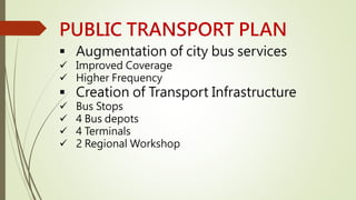
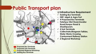
CONTENTS... 
OVERVIEW OF CITY 
TYPES OF TRANSPORT 
EXISTING SCENERIO 
TRANSPORT SYSTEM 
DEVELOPING ROADS IN THE CITY 
EXISTING ROAD FROM OLD TIME
TYPES OF TRANSPORT 
 AIR 
 Air India connects Agra to rest of the world via Mumbai, Delhi 5 days a 
week 
 RAILWAYS 
 Agra is on the central train line between Delhi and Bombay and 
between Delhi and Madras by many trains . 
 ROADWAYS 
 Discussed further
OVERVIEW OF CITY 
 STUDY AREA 
 Agra Development Authority-520sq.km 
 Agra Nagar Nigam-141sq.km 
 Population Density-9000 persons per 
sq.km 
 Decadal Population Growth Rate-30.37% 
 Average Trip Length-4.9km 
 Area under Traffic and Transportation- 
10%
EXISTING SCENERIO 
 Good network of highways 
radiating outwards, however, 
absence of a ring road 
connectivity to link 
peripheral areas. 
 NH-2- to Delhi in north 
direction and to Kolkata via 
Kanpur towards east. 
 NH-11-to Jaipur. 
 NH-3-to Mumbai. 
 NH-93-Aligarh 
3 
93
TRANSPORT SYSTEM 
 Road Network 
 2 –Lane carriageway -52% 
 Undivided carriageway-77% 
 Road marking –absent on 87% of the network 
6-8 Lanes 
4% 
4-6 Lanes 
35% 
up to 2 
Lanes 
8% 
2-4 Lanes 
53% 
Type of carriage width % 
6-8 Lanes 4-6 Lanes up to 2 Lanes 2-4 Lanes 
Auto 
20% PT 
4% 
Car 
1% 
2w 
21% 
Cycle 
17% 
Walk 
37% 
Mode of travel 
Auto PT Car 2w Cycle Walk
PUBLIC TRANSPORT PLAN 
 Augmentation of city bus services 
 Improved Coverage 
 Higher Frequency 
 Creation of Transport Infrastructure 
 Bus Stops 
 4 Bus depots 
 4 Terminals 
 2 Regional Workshop
Public Transport plan 
Proposed Bus Terminals 
Proposed Sub Terminals 
Proposed Regional Workshop 
Existing Bus Terminals 
 Infrastructure Requirement 
 Existing Bus Terminals 
o ISBT, Idgah & Agra Fort 
 4 Proposed Bus Terminals 
o Fatehpur Sikri Road,Gwalior 
Road,Kanpur Road & 
Shastripuram. 
 4 Sub Terminals 
o Collectrate,Bhagwan Talkies, 
Water Works Crossing, 
Cantonment Railway Station 
 2 Regional Workshop
DEVELOPING ROADS IN THE CITY 
Agra Master Plan 2001-2021 
 Accessibility within ADA 
 Connectivity to the new growth 
centres 
 Development of areas near 
arterials 
 Radial Network complemented 
by circumferential roadway 
system . 
 11 radials will have to be 
connected by 3 orbital’s. 
 Access to the Taj will shifts 
towards the west of the city. 
KANPUR 
DELHI 
BHARATPUR 
JAIPUR
EXISTING ROAD FROM OLD 
TIME  NH-2- is the 
road which 
is existing 
from old 
time.
THANKS
REFRENCES- 
 CMP AGRA 
 GOOGLE MAPS 
 AGRA’S OFFICIAL WEBSITE

Agra Transportation Highlights

  • 2.
    CONTENTS... OVERVIEW OFCITY TYPES OF TRANSPORT EXISTING SCENERIO TRANSPORT SYSTEM DEVELOPING ROADS IN THE CITY EXISTING ROAD FROM OLD TIME
  • 3.
    TYPES OF TRANSPORT  AIR  Air India connects Agra to rest of the world via Mumbai, Delhi 5 days a week  RAILWAYS  Agra is on the central train line between Delhi and Bombay and between Delhi and Madras by many trains .  ROADWAYS  Discussed further
  • 4.
    OVERVIEW OF CITY  STUDY AREA  Agra Development Authority-520sq.km  Agra Nagar Nigam-141sq.km  Population Density-9000 persons per sq.km  Decadal Population Growth Rate-30.37%  Average Trip Length-4.9km  Area under Traffic and Transportation- 10%
  • 5.
    EXISTING SCENERIO Good network of highways radiating outwards, however, absence of a ring road connectivity to link peripheral areas.  NH-2- to Delhi in north direction and to Kolkata via Kanpur towards east.  NH-11-to Jaipur.  NH-3-to Mumbai.  NH-93-Aligarh 3 93
  • 6.
    TRANSPORT SYSTEM Road Network  2 –Lane carriageway -52%  Undivided carriageway-77%  Road marking –absent on 87% of the network 6-8 Lanes 4% 4-6 Lanes 35% up to 2 Lanes 8% 2-4 Lanes 53% Type of carriage width % 6-8 Lanes 4-6 Lanes up to 2 Lanes 2-4 Lanes Auto 20% PT 4% Car 1% 2w 21% Cycle 17% Walk 37% Mode of travel Auto PT Car 2w Cycle Walk
  • 7.
    PUBLIC TRANSPORT PLAN  Augmentation of city bus services  Improved Coverage  Higher Frequency  Creation of Transport Infrastructure  Bus Stops  4 Bus depots  4 Terminals  2 Regional Workshop
  • 8.
    Public Transport plan Proposed Bus Terminals Proposed Sub Terminals Proposed Regional Workshop Existing Bus Terminals  Infrastructure Requirement  Existing Bus Terminals o ISBT, Idgah & Agra Fort  4 Proposed Bus Terminals o Fatehpur Sikri Road,Gwalior Road,Kanpur Road & Shastripuram.  4 Sub Terminals o Collectrate,Bhagwan Talkies, Water Works Crossing, Cantonment Railway Station  2 Regional Workshop
  • 9.
    DEVELOPING ROADS INTHE CITY Agra Master Plan 2001-2021  Accessibility within ADA  Connectivity to the new growth centres  Development of areas near arterials  Radial Network complemented by circumferential roadway system .  11 radials will have to be connected by 3 orbital’s.  Access to the Taj will shifts towards the west of the city. KANPUR DELHI BHARATPUR JAIPUR
  • 10.
    EXISTING ROAD FROMOLD TIME  NH-2- is the road which is existing from old time.
  • 11.
  • 12.
    REFRENCES-  CMPAGRA  GOOGLE MAPS  AGRA’S OFFICIAL WEBSITE