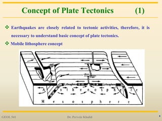
Downloaded 130 times
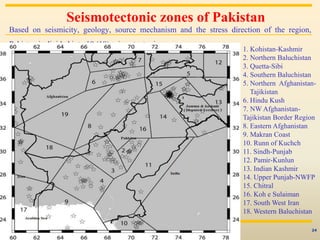

This document provides an overview of seismotectonics and its importance in understanding earthquake hazards. It defines seismotectonics as the relationship between earthquakes, active tectonics and faults in a region. Seismotectonic maps and zonation are used to identify active faults and determine zones of similar seismic potential. Together with information on regional tectonics, historical seismicity, and stress fields, seismotectonics allows scientists to assess earthquake hazards by identifying capable faults. The document outlines these concepts and techniques and provides examples of seismotectonic analysis in Pakistan.


![谷歌留痕技术 [ 𝙩𝙤𝙥 𝟮𝟯𝟯. 𝙘 𝙤𝙢 ]](https://cdn.slidesharecdn.com/ss_thumbnails/top233-260130174328-3833018c-thumbnail.jpg?width=640&height=640&fit=bounds)
