Downloaded 21 times


![Culture Mandala: Bulletin of the Centre for East-West Cultural and Economic Studies, Vol. 10, No. 1, December 2012- May
2013, pp21-50. Copyright © Jason Fritz 2013
27
discussion of “unique digital interface[s]’, but capability does not ensure implementation (GAO
2002).
Hardening
The security technique of hardening can take place at multiple nodes within a satellite network.
Commonly used physical protection of ground stations includes: access codes, activity logs, blast
resistant physical structures, employee screening, cameras, fences, identification checks, radomes
(enclosures to protect antennas), and security guards. In the case of military or government satellite
ground stations, they are often located within military compounds which already have heavy
security measures in place. Insider threats are of particular concern for hacking as they can bypass
security and gain useful information or alter systems to make remote access possible. Beyond
physical security, and even beyond computer networks, ground stations need to be concerned with
electronic intrusion, such as radio signal interception and jamming. Close proximity to the ground
station provides more opportunities for hackers, such as introducing signal noise, polarization, or
side-lobe meaconing, which involves the interception and rebroadcasting of signals (Steinberger
2008). This is comparable to ‘war driving’ in the computer realm. To defend against this antennas
are often obscured from view by constructed or natural barriers to prevent attacks that are
dependent on line of sight. Techniques are also used to identify interference, and the surveillance
footprint around the ground station is increased. Additionally, link transmissions can employ:
Error protection coding to increase the amount of interference that can be tolerated before
communications are disrupted, directional antennas that reduce interception or jamming
vulnerabilities, shielding and radio emission control measures that reduce the radio energy
that can be intercepted for surveillance or jamming purposes; narrow band excision
techniques that mitigate jamming by using smaller bandwidth, burst transmissions and
frequency-hopping (spread-spectrum modulation) methods that communicate data in a short
series of signals or across a range of radio frequencies to keep adversaries from “locking-on”
to signals to jam or intercept them, antenna side-lobe reduction designs that mitigate jamming
or interception vulnerabilities, nulling antenna systems (adaptive interference cancellation),
and developing new technologies and procedures , such as lasers, [to] transmit information
at very high bit rates and have very tight beams (Space Security Index 2012).
Hardening of satellites themselves involves the use of “designs and components that are built to be
robust enough to withstand harsh space environments and deliberate attacks” (GAO 2002). As with
hardening the other nodes in a satellite network, the major drawback is increased cost:
Although all parts used in satellites are designed to withstand natural environmental
conditions, some very high-quality parts that have undergone rigorous testing and have
appreciably higher hardness than standard space parts are also available, including those
referred to as class “S” parts. These higher quality space parts cost significantly more than
regular space parts—partly because of the significant testing procedures and more limited
number of commercial providers manufacturing hardened parts. According to an industry
official, high-quality space parts are used by the military and are generally not used on
commercial satellites (GAO 2002).
Enhanced manoeuvring and stealth capabilities of satellites, an emerging area of defensive capacity,
can also be placed under the category of hardening.
Encryption
The role of signal encryption is another aspect of satellite structure which is difficult to ascertain in
part because of the large number of satellite operators. All satellite signals can be encrypted, but
whether they are or not, and the quality or strength of encryption used, is unknown and often](https://image.slidesharecdn.com/satellite-hacking-150127214742-conversion-gate02/85/Satellite-hacking-7-320.jpg)
![Culture Mandala: Bulletin of the Centre for East-West Cultural and Economic Studies, Vol. 10, No. 1, December 2012- May
2013, pp21-50. Copyright © Jason Fritz 2013
28
classified. A single satellite vendor can employ encryption on a case by case basis depending on the
perceived security risk associated with the data being transmitted. Multiple nodes can be encrypted
as well, such as TT&C uplinks, data uplinks, or access between terrestrial networks and the ground
stations, or combinations thereof. In some cases special decryption hardware is also required “at
the data’s source and destination” with additional security precautions in place to restrict “access to
the equipment and allowing no access by foreign nationals” (GAO 2002).
What can be ascertained is that encryption adds to the cost of operation and reduces efficiency,
therefore commercial satellite operators are the least likely to implement its use. According to
researchers at a 2008 security conference, encrypting satellite signals can cause an 80% drop in
performance (Geovedi, Iryandi, and Zboralski, 2008). The cost factor can also include the cost of
implementing or upgrading systems to allow encryption, as well as training staff on its proper use.
Further, satellite transmissions can encompass multiple countries, with different countries having
their own laws regarding the use of cryptography, creating legal obstacles that might persuade
against the use of encryption (Greenberg 2010). “[National Security Agency] NSA officials stated
that not all commercial providers’ tracking and control uplinks are encrypted. Concerning the data
links, customers are responsible for determining whether they are encrypted or not. Most
commercial satellite systems are designed for ‘open access,’ meaning that a transmitted signal is
broadcast universally and unprotected” (GAO 2002). Using encryption does not guarantee security
either; it is only an added layer of defence. For example, researchers at the University of Bochum in
Germany claimed to have cracked the A5-GMR-1 and A5-GMR-2 algorithms used by some satellite
phones (Messmer 2013).
Case Study: Drones
The rise of Unmanned Aerial Vehicles (UAVs), or drones, presents one example of a subgroup using
satellite networks and the role of encryption. The International Institute for Strategic Studies
identified 807 drones in active service around the world not including any that may be in use by
China, Turkey, and Russia (Rogers 2012). Some estimates place the number of enemy combatants
killed by US drones at 4,700, and the US military has introduced a new Distinguished Warfare Medal
to honour drone pilots and computer network operators (Knox 2013 and Dwyer 2013). While the
use of these drones remains contentious, their numbers and use continue to rise and additional
markets are opening up. For example, in November 2012 Northrup Grumman began sea trials of its
carrier based drone the X47-B, expected to enter service before 2020 (Skillings 2012). Meanwhile
other defence contractors are developing competing designs, such as Boeing’s Phantom Ray. Law
enforcement and news agencies are also paving the way for domestic use, making Hollywood scenes
of surveillance drones (They Live), rapid journalism (Back to the Future II), and assisting in criminal
apprehension (Minority Report) closer to reality (Towards a Swarm of Nano Quadrotors 2012). The
FAA “forecasts an estimated 10,000 civilian drones will be in use in the US” by 2018 (Lowly 2013).
But what role do satellites play in drones? Smaller remote controlled vehicles used by soldiers on
the battlefield over short distances do not use satellites to relay communication. Even the X47-B
does not, relying instead on autonomous programming (Weinberger 2012). However the larger
Global Hawk reconnaissance UAV does rely on satellites to communicate globally with command and
control, as do unmanned combat aerial vehicles (UCAVs), such as the Predator and Reaper, used for
delivering strikes (Norris 2010, pp230-232; Wong and Fergusson 2010, p59). Being closer to the
ground than satellites, these UAVs provide greater image detail and strike capability without
violating international space treaties. These drones are like an additional mid atmosphere node in
the broad structure template, or perhaps the drone itself could be considered a type of VSAT or user
terminal. According to an article in The Wall Street Journal:](https://image.slidesharecdn.com/satellite-hacking-150127214742-conversion-gate02/85/Satellite-hacking-8-320.jpg)
![Culture Mandala: Bulletin of the Centre for East-West Cultural and Economic Studies, Vol. 10, No. 1, December 2012- May
2013, pp21-50. Copyright © Jason Fritz 2013
29
The Air Force has staked its future on unmanned aerial vehicles. Drones account for 36% of
the planes in the [US Air Force’s] proposed 2010 budget. General Atomics expects the Air
Force to buy as many as 375 Reapers (Gorman, Dreazen, and Cole 2009).
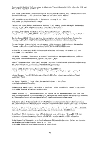
Domestic-use UAVs are an emerging field, so their common design features are not yet certain.
However, an illustration in a 2013 Government Accountability Office report titled “Conceptual
Rendering of Unmanned Aircraft System” shows a satellite as a part of the domestic network (see
figure 6).
Figure 6 (GAO 2013)
UAVs have already come to the attention of hackers. Insurgents in Iraq and Afghanistan used a 26
US$ off the shelf software program called SkyGrabber, from Russian company SkySoftware, to
capture unencrypted Predator video feeds. SkyGrabber accesses data being broadcast by satellites,
allowing users to tune into different data streams comparable to tunning in broadcast radio stations
(Ward 2009). This did not allow the insurgents to control or disrupt the UAVs; it only allowed them
to eavesdrop on the signals being sent (see the next section on types of hacking). However this was
alarming for several reasons. First, of all types of satellite operators the military is thought to
implement the highest level of security measures, and yet encryption was not being used. Once this
particularly weakness was exposed it had to be fixed, which added cost to the program, took time to
implement, and reduced efficiency of the equipment. Secondly, the information gained by
insurgents might have revealed the areas that were under surveillance and patterns of drone use,
providing them with information they could use to avoid detection or set up an ambush (Gorman,
Dreazen, and Cole 2009). Under asymmetric warfare, exploiting weaknesses in drones and an
opponent’s reliance on them could be used as part of a larger “blinding campaign” (Krepinevich
2010 and Tol 2010). As Captain J W Rooker of the US Marines states, “If an enemy can disable or
destroy the satellites on which these systems depend, or hack, jam, or spoof them, he will have
effectively gouged out our eyes” (Rooker 2008).
Internet Connected
It is difficult to determine the depth of Internet connectivity in satellite networks. As previously
noted, there are currently 1046 operational satellites belonging to 47 states. Of these, 46 are civil,
388 commercial, 190 government, 203 military, and 219 a combination of these four (UCS Satellite
Database 2012). Many of these were custom built for their mission, and detailed information on the
Internet connectivity of any one of them is likely restricted as a security precaution. While the limits
of science, technology, and cost force operators to follow a general template, even minor variations](https://image.slidesharecdn.com/satellite-hacking-150127214742-conversion-gate02/85/Satellite-hacking-9-320.jpg)
![Culture Mandala: Bulletin of the Centre for East-West Cultural and Economic Studies, Vol. 10, No. 1, December 2012- May
2013, pp21-50. Copyright © Jason Fritz 2013
30
can alter the ability to hack them. A hacker might limit their study to one specific satellite network;
whereas this paper is attempting to discuss the topic as a whole. What is known is that satellites
and ground stations predate the modern Internet. As development of satellite systems move away
from one-off designs and attempt to increase their capability, Internet connections with them are
likely to rise. Therefore cyber-attacks on satellite networks may be an emerging threat (Prime 2012).
A 2004 study published by the US President’s National Security Telecommunications Advisory
Committee “emphasized that the key threats to the commercial satellite fleet are those faced by
ground facilities from computer hacking or possibly, but less likely, jamming” (Space Security Index
2012). VSATs are capable of direct contact with satellites, as well as contact with the hub. Many of
the 1.4 million VSATs are connected to the Internet since Internet access is one of the services VSAT
retailers are selling. This provides an Internet-based entry point into those satellite networks, either
by hacking into VSAT signals or by procuring a VSAT of their own.
In reference to the IRIS payload that is planned to be carried on-board INTELSAT 14 … its
use of Internet protocol (IP) packet routing may cause the satellite to be susceptible to all of
the vulnerabilities of IP packet routing. IP packet routing was intended to make routing as
easy as possible. A packet routed with IP could be accessed, re-routed, or copied by anyone
connected to the network. IP networks are susceptible to spoofing, sniffing, and session
hijacking (Steinberger 2008).
Of more interest might be how connected the hub is to the terrestrial Internet, since access to a
VSAT hub might allow TT&C control or the disabling of on-board satellite defences thereby
increasing what could be done from a VSAT. It should be noted that compromising one VSAT
network puts only a small number of the total satellites in orbit at risk since there is such a high
diversity of operators. Add to this that a hub or ground station can be Internet connected, while the
TT&C or communication data uplinks are not - it is possible to air gap the two. However; close
proximity of the two computer networks increases the chance of careless configuration or roaming
removable storage that could yield privilege escalation. The following case study focuses on an
individual operator, NASA, from the perspective of Internet access vulnerability.
Case Study: NASA
The US Office of Inspector General (OIG) revealed several Internet based vulnerabilities in NASA
computers systems, including those that control spacecraft like the International Space Station and
Hubble Telescope.
Specifically, six computer servers associated with IT assets that control spacecraft and
contain critical data had vulnerabilities that would allow a remote attacker to take control of or
render them unavailable. Moreover, once inside the Agency-wide mission network, the
attacker could use the compromised computers to exploit other weaknesses we identified, a
situation that could severely degrade or cripple NASA’s operations. We also found network
servers that revealed encryption keys, encrypted passwords, and user account information to
potential attackers. These data are sensitive and provide attackers additional ways to gain
unauthorized access to NASA networks (Martin 2011).
Among OIG’s recommendations was for NASA to identify all Internet accessible computers on their
mission networks and take action to mitigate associated risks. From this it can be extrapolated that
NASA is not even aware of which computers have direct Internet connectivity. NASA depends on
international cooperation, receiving input from global leaders in a wide range of fields. The Internet
facilitates this, yet requires careful monitoring in its architecture in order to limit access to sensitive
data and controls. NASA’s size also poses conflicting security/productivity problems. NASA
maintains more than “550 [dispersed] information systems” including “computer systems and](https://image.slidesharecdn.com/satellite-hacking-150127214742-conversion-gate02/85/Satellite-hacking-10-320.jpg)
![Culture Mandala: Bulletin of the Centre for East-West Cultural and Economic Studies, Vol. 10, No. 1, December 2012- May
2013, pp21-50. Copyright © Jason Fritz 2013
31
projects that control the Hubble Space Telescope, the Space Shuttle, the International Space Station,
the Cassini and Lunar Reconnaissance orbiters, and several ground stations and mission control
centers” (Martin 2012 and Martin 2011). According to a 2008 NASA quarterly report, “satellites
from several US government space programs utilize commercially operated satellite ground stations
outside the United States, some of which rely on the public Internet for data access and file
transfers” (USCC 2011). In 2010 and 2011, NASA reported 5,408 computer security incidents that
resulted in the installation of malicious software on or unauthorized access to its systems. A portion
of these were advanced persistent threats believed to be state sponsored rather than individual
hackers, hacker groups, or other non-state actors. Gaining access to NASA’s computer systems can
provide clues or open additional pathways for exploiting satellites.
Concern over escalating privileges also extends to the hardware used in satellite systems. OIG’s
investigation revealed improper sanitization and disposal of excess Shuttle IT equipment, resulting in
the attempted sale of computers and hard drives which still contained sensitive data, one of which
was subject to export control restriction, and the discovery of excess hard drives in an unsecured
dumpster accessible to the public at one centre (Martin 2012). Further, as of 2012 only 1 percent of
NASA’s mobile devices, such as laptops, have been encrypted. This is particularly significant given
NASA’s reported loss or theft of 48 mobile computing devices between 2009 and 2011. For
example, “the March 2011 theft of an unencrypted NASA notebook computer resulted in the loss of
the algorithms used to command and control the International Space Station. Other lost or stolen
notebooks contained Social Security numbers and sensitive data on NASA’s Constellation and Orion
programs” (Martin 2012). Worms and viruses have also made their way onto laptops which were
then physically transported onto the International Space Station. It is unknown which, if any, on-
board systems these laptops might connect with while in orbit. According to one account, “the virus
did make it onto more than one laptop — suggesting that it spread via some sort of intranet on the
space station or via a thumb drive” (Singel 2008).
The following is a select timeline of intrusions into NASA’s computer systems, many of which are
alleged to be Chinese or Russian state sponsored. Regardless of whether or not these incidents
were state sponsored, they illustrate the existence of an Internet-based vulnerability, concerns that
reverse engineering and analysis of sensitive hardware could be used against satellites, and the
capability of drawing two states into conflict. Many of these incidents are cases of computer
hacking, rather than satellite hacking, yet they can be used as a stepping stone for attacking
satellites, and these computers could be considered part of the ground station portion of NASA’s
satellite systems or part of the ground-based terrestrial network interconnections.
Table 1: Timeline of Intrusions into NASA systems
1997 Trespassers penetrated computers in the X-ray Astrophysics Section of a building on NASA’s
Goddard Space Flight Center campus, where they commandeered computers delivering data
and instructions to satellites. Before being discovered, the intruders transferred huge
amounts of information, including e-mails, through a series of stops on the Internet to
computers overseas. The advisory stated: "Hostile activities compromised [NASA] computer
systems that directly and indirectly deal with the design, testing, and transferring of satellite
package command-and-control codes"—in other words, computerized instructions
transmitted to spacecraft (Epstein and Elgin 2008).
1998 A US-German ROSAT satellite, used for peering into deep space, was rendered useless after
it turned suddenly toward the sun damaging the High Resolution Imager by exposure. NASA
investigators later determined that the accident was linked to a cyber-intrusion at the
Goddard Space Flight Center. The attack allegedly originated from Russia (Epstein and Elgin
2008).](https://image.slidesharecdn.com/satellite-hacking-150127214742-conversion-gate02/85/Satellite-hacking-11-320.jpg)

![Culture Mandala: Bulletin of the Centre for East-West Cultural and Economic Studies, Vol. 10, No. 1, December 2012- May
2013, pp21-50. Copyright © Jason Fritz 2013
33
2008 On June 20, 2008,Terra EOS [earth observation system] AM–1, a National Aeronautics and
Space Administration-managed program for earth observation, experienced two or more
minutes of interference. The responsible party achieved all steps required to command the
satellite but did not issue commands (USCC 2011).
2008 On October 22, 2008, Terra EOS AM–1 experienced nine or more minutes of interference.
The responsible party achieved all steps required to command the satellite but did not issue
commands (USCC 2011).
2008 “…hackers are thought to have loaded a Trojan horse in the computers at Johnson Space
Center in Houston, Texas. These hackers then used the Trojan horse to access the uplink to
the International Space Station (ISS) and disrupt certain operations on-board, such as email.
The attack was helped by the fact that ISS on-board computers are running older software
for which security fixes are no longer available. . . .” (Steinberger 2008)
2010 A Chinese national was detained for hacking activity targeting US government agencies.
Seven NASA systems, many containing export-restricted technical data, were compromised
(Martin 2012).
2010 For about 18 minutes on April 8, 2010, China Telecom advertised erroneous network traffic
routes that instructed US and other foreign Internet traffic to travel through Chinese servers.
Other servers around the world quickly adopted these paths, routing all traffic to about 15
percent of the Internet’s destinations through servers located in China. This incident
affected traffic to and from US government (‘‘.gov’’) and military (‘‘.mil’’) sites, including
those for NASA (USCC 2010).
2011 Romanian hacker TinKode allegedly obtained sensitive information from NASA’s Goddard
Space Flight Center and the European Space Agency which he then made publicly available
online. The information included Login credentials for admin, content management,
databases, email accounts, file upload (FTP), and other key systems (Leyden 2011 and Prime
2012).
2011 NASA’s Jet Propulsion Laboratory (JPL) “reported suspicious network activity involving
Chinese-based IP addresses... giving the intruders access to most of JPL’s networks” (Martin
2012).
2013 Chinese national Bo Jiang, a former NASA contractor, was arrested as he was attempting to
return to China with "a large amount of information technology that he may not have been
entitled to possess,"… NASA shut down access to an online database and banned new
requests from Chinese nationals seeking access to its facilities amid mounting concerns
about espionage and export control violations…. The security measures include a complete
ban on remote computer access by Chinese contractors already working at NASA centers
(Klotz 2013). NASA employs 118 Chinese nationals in "remotely-based" information
technology jobs that may enable them to penetrate the space agency's national security
database servers, and 192 Chinese nationals in positions with "physical access" to NASA
facilities (Pollock 2013).
2013 The US Congress passed a provision which prohibits the Commerce and Justice
departments, NASA and the National Science Foundation from buying any information
technology system that is "produced, manufactured or assembled" by any entity that is](https://image.slidesharecdn.com/satellite-hacking-150127214742-conversion-gate02/85/Satellite-hacking-13-320.jpg)

![Culture Mandala: Bulletin of the Centre for East-West Cultural and Economic Studies, Vol. 10, No. 1, December 2012- May
2013, pp21-50. Copyright © Jason Fritz 2013
35
ground station or user terminal receiving a downlink. Jamming the uplink requires more skill and
power than a downlink, but its range of disruption tends to be greater, blocking all possible
recipients rather than a terrestrial range limited portion (GAO 2002). Jamming would most likely fall
under the larger title of EW rather than CNO, although the Internet might be used to obtain
frequencies, schedules, and ground station layouts. Additionally, jamming could be considered CNO
in more technical scenarios such as using one satellite to jam another. A DDoS or other malicious
cyber-attack against computers used for ground station operations could also effectively jam a
satellite. Even though the signal itself would not be attacked, an essential component of the satellite
system would be. Below is a timetable of documented incidents.
Table 2: Timeline of Documented Jamming Incidents
1995 Kurdish satellite channel, MED-TV, was intentionally jammed because it was believed to be
promoting terrorism and violence (GAO 2002).
1997 Resulting from the use of a disputed orbital slot, Indonesia jammed the communication
satellite APSTAR-1A by transmitting interference from their own satellite Palapa B1.
APSTAR-1A was being leased from the island nation of Tonga by Hong Kong based APT
Satellite Company to broadcast into the PRC. Indonesia had peacefully settled a prior
dispute in 1992 involving the same orbital slot, that time conflicting with a Russian Gorizont
commercial communications satellite being leased by American company Rimsat (GAO 2002,
and Wong and Fergusson 2010, p85).
1998 Kurdish satellite channel, MED-TV, launches “a major campaign to combat what it alleges is
the persistent interference of its transmissions by the Turkish Government…taking the issue
to the European Court of Human Rights and [gaining] the backing of [an] anti-censorship
pressure group … (Kurds retaliate in Turkish jam war 1998)”.
2000 During tank trials in Greece, the British Challenger and United States Abrams suffered from
GPS navigational problems. An investigation later revealed that those signals were being
jammed by a French security agency (Grau 2000).
2003 The Cuban and Iranian governments collaborated to jam Telstar 12, a US commercial
communications satellite in geostationary orbit used to transmit programming by Voice of
America to Iran (Waller 2003).
2003 Iraq acquired GPS jamming equipment during Operation Iraqi Freedom allegedly from
Russian company Aviaconversiya Ltd. Six jamming sites were discovered and destroyed in
the air campaign prior to ground operations (Wong and Fergusson 2010, p85). The
equipment’s effectiveness appeared to be negligible; however it does suggest “that jamming
capabilities could proliferate through commercial means” (Space Security Index 2012).
2004 The mobile, ground-based CounterCom system, designed to provide temporary and
reversible disruption of a targeted satellite’s communications signals, was declared
operational. In 2007 this was upgraded to seven jamming units, up from the original two.
Next-generation jammers will likely have ‘enhanced capabilities for SATCOM denial,’ using
largely commercially available components (Space Security Index 2012).](https://image.slidesharecdn.com/satellite-hacking-150127214742-conversion-gate02/85/Satellite-hacking-15-320.jpg)


![Culture Mandala: Bulletin of the Centre for East-West Cultural and Economic Studies, Vol. 10, No. 1, December 2012- May
2013, pp21-50. Copyright © Jason Fritz 2013
38
Solidarność (Solidarity) over state-run television broadcasts in Torun… The messages read
‘Enough price increases, lies, and repressions. Solidarity Torun’ and ‘It is our duty to boycott
the election’ with the inclusion of the Solidarity logo (Jan Hanasz: The Polish TV Pirate 1990).
1986 A Florida man using the name Captain Midnight disrupted the uplink to a Galaxy I satellite.
For 4 to 5 minutes viewers of HBO on the US East coast saw the following message, placed
over SMPTE colour bars:
GOODEVENING HBO
FROM CAPTAIN MIDNIGHT
$12.95/MONTH ?
NO WAY !
[SHOWTIME/MOVIE CHANNEL BEWARE!]
(GAO 2002, The Story of Captain Midnight 2007, and Rooker 2008).
1987 The Playboy Channel, based on the popular adult magazine, had its signal hijacked by an
employee of the Christian Broadcasting Network. “He was indicted for a violation of 18 USC
1367 (satellite jamming). In a week-long trial in Norfolk, VA, evidence was produced by the
prosecutor that showed that both the character generator and the transmitter at CBN
matched the tape recording of the jamming” (Bellows 2007).
1987 A Max Headroom impersonator overtook the television signal of two Chicago based stations,
commandeering a live news broadcast and an episode of Dr. Who for 25 seconds and 90
seconds respectively (Bellows 2007).
2002 The Falun Gong illegally used an AsiaSat satellite to broadcast into China disrupting
broadcasts of China Central TV (CCTV) with anti-government messages (Morrill 2007 and
Steinberger 2008). It is unclear from these reports how often this happened and for what
duration, or whether all instances used an open transponder on a bent pipe structure or
required overpowering other signals.
2006 “During the 2006 Lebanon War, Israel overloaded the satellite transmission of Hezbollah's Al
Manar TV to broadcast anti-Hezbollah propaganda. One spot showed Hezbollah leader
Hassan Nasrallah with crosshairs superimposed on his image followed by three gunshots and
a voice saying ‘Your day is coming’ and shots of the Israeli Air Force destroying targets in
Lebanon” (Friedman 2006).
2007 An intrusion incident occurred on Czech Television's Sunday morning programme Panorama,
which shows panoramic shots of Prague and various locations across the country, to
promote tourism. One of the cameras, located in Černý Důl in Krkonoše, had been
tampered with on-site and its video stream was replaced with the hackers' own, which
contained CGI of a small nuclear explosion in the local landscape, ending in white noise
(Wohlmuth 2007).
2007 A grainy photo of a man and woman interrupted Washington, DC ABC affiliate WJLA's digital
or HD signal for two hours. The incident was initially deemed a genuine signal intrusion by
various websites but has since been confirmed to be the result of an older HDTV encoder
malfunctioning in the early morning hours and going undetected (Swann 2007).
2007 The Tamil Tigers (LTTE) in Sri Lanka illegally broadcast their propaganda over Intelsat
satellites (Jayawardhana 2007, Morrill 2007, and Steinberger 2008).](https://image.slidesharecdn.com/satellite-hacking-150127214742-conversion-gate02/85/Satellite-hacking-18-320.jpg)

![Culture Mandala: Bulletin of the Centre for East-West Cultural and Economic Studies, Vol. 10, No. 1, December 2012- May
2013, pp21-50. Copyright © Jason Fritz 2013
40
2008 “On June 20, 2008,Terra EOS [earth observation system] AM–1, a National Aeronautics and
Space Administration-managed program for earth observation, experienced two or more
minutes of interference. The responsible party achieved all steps required to command the
satellite but did not issue commands” (USCC 2011).
2008 “On October 22, 2008, Terra EOS AM–1 experienced nine or more minutes of interference.
The responsible party achieved all steps required to command the satellite but did not issue
commands” (USCC 2011).
Non-hacking examples that illustrate the possible effect satellite takeover could have:
1997 A ground based transmitter unintentionally interfered with the GPS receiver of a commercial
aircraft causing the plane to temporarily lose all of its GPS information (GAO 2002).
1998 The failure of PANAMSAT’s Galaxy IV satellite, attributable to an on-board processor
anomaly, disabled 80 to 90 percent of 45 million pagers across the United States for 2 to 4
days, and blocked credit card authorization at point-of-sale terminals (such as gasoline
pumps), leaving approximately 70 percent of a major oil company’s customers without the
ability to pay for services at the pump (GAO 2002).
4. Additional Satellite System Vulnerabilities
This section covers “additional” satellite system vulnerabilities - several vulnerabilities have already
been revealed through the discussion in section two. For example, defensive measures such as
redundancy, hardening, and encryption all have deterrents to their use and for some satellite
operators the benefits of Internet connectivity outweigh the perceived risk. Also, increasing the
availability and mobility of VSATs and BGAN, along with lowering the technical expertise required to
operate them, has the unintended consequence of making satellites accessible to a greater number
of hackers. This section will examine aspects of vulnerability not yet fully explored, including the
lure of cost saving methods, military reliance on commercial satellites, attribution difficulties,
globalization’s effect on security, and the role of international governance.
Cost Saving Methods
A root cause of many satellite vulnerabilities is an attempt to cut cost. As explored in Section two,
profit driven risk assessment, particularly with commercial operators, has resulted in increased
Internet connectivity and reduced redundancy, hardening, and encryption. Increasing Internet
connectivity of satellite systems increases performance and reduces the cost of operations, but it
exposes satellite systems to increased risk of malicious activity. Implementing redundancy
techniques requires the purchasing of backup hardware, software, satellites, and ground stations;
while efforts to reduce the cost of redundancy, such as microsatellites and standardized equipment,
open up new vulnerabilities including a lack of diversity. Hardening of ground stations requires
increased infrastructure and staff, hardening of uplinks and downlinks requires additional equipment
and expertise, and hardening of the satellites requires higher cost parts that have undergone
extensive testing and can withstand greater stress. Encryption lowers performance and increases
cost, in some cases requiring additional hardware, training, difficult upgrades, and legal obstacles. In
contrast with protecting satellites, hacking satellites has the lure of being relatively cheap (Laurie
2009, Greenberg 2010, Szczys 2011, and IndianZ 2012). Instead of acquiring the missile launch and
guidance capability of an anti-satellite (ASAT) weapon, a capability thus far only demonstrated by](https://image.slidesharecdn.com/satellite-hacking-150127214742-conversion-gate02/85/Satellite-hacking-20-320.jpg)
![Culture Mandala: Bulletin of the Centre for East-West Cultural and Economic Studies, Vol. 10, No. 1, December 2012- May
2013, pp21-50. Copyright © Jason Fritz 2013
41
three states, it might be cheaper and easier to hack the intended target. Thus cyber-attacks fit into
the general schema of asymmetric strategies that can be deployed by small or developing states,
NGOs, militant groups, and in some cases skilled individuals.
A typical satellite can have a lifespan of 15 years, yet technology on the ground can drastically
change in that time. For this reason older satellites might be more vulnerable as defences may be
less stringent, security flaws can be exposed over time, and there are limited means to patch those
flaws once it is in orbit. Some modern satellites have payloads and busses capable of receiving
updates from the ground; however this opens a new vulnerability in that the updates could be
corrupted. During a satellite’s lifespan new commercial-off-the-shelf (COTS) products capable of
inflicting harm may also become available to hackers. Efforts are underway to streamline the
manufacturing of universal buses that can house unique payloads, yet the bus itself is critical to the
satellite’s function and reducing variety may increase vulnerability (Norris 2010 and Butler 2013).
Most satellite components still require specialized components, but as technology improves, there is
an increased risk of COTS being used to save money, further limiting security (Steinberger 2008).
Another cost saving practice is the “leasing [of] commercial telecommunication lines for long-haul
communications”. This “trend from dedicated to shared lines for communications also expands the
surface area for cyber attack” (Prime 2012). A lack of training can result in existing security features
being unused or improperly configured (Geovedi, Iryandi, and Zboralski, 2008).
Military Reliance on Commercial Satellites
While government and military satellite operators place security as a high priority, commercial
satellite operators are primarily concerned with profit. A low number of satellite disruptions
incidents to date might cause companies to view reduced security as an acceptable risk in
comparison with the cost of implementing higher security and reducing productivity. This “raises
security concerns, since a number of military space actors are becoming increasingly dependent on
commercial space assets for a variety of applications” (Space Security Index 2012). While
governments rely on commercial satellite operators, they are not the primary customer, accounting
for only 10% of the market in the US. “As a result, federal customers generally have not influenced
security techniques used for commercial satellites” (GAO 2002).
Although the government owns satellites, it also relies for certain services on satellites owned
and operated by commercial satellite service providers. For example, the Department of
Defense (DOD) typically relies on commercial satellites to fulfil its communications and
information transmission requirements for non–mission-critical data and to augment its
military satellite capabilities. The importance of commercial satellites for DOD is evident
during times of conflict: according to a DOD study, commercial communications satellites
were used in 45 percent of all communications between the United States and the Persian
Gulf region during Desert Shield/Desert Storm… Further, during operations in Somalia from
December 1992 through March 1994, U.S. military and commercial satellite coverage was not
available, so Russian commercial satellites were used (GAO 2002).
84% of military communications during Operation Iraqi Freedom were transmitted through
commercial satellites (Shachtman 2008 and Steinberger 2008). Beyond military reliance, commercial
satellites are a critical component of national and global economies. Therefore security
vulnerabilities in commercial satellites are a concern for governments even if their military is not
using them. Other countries with a heavy reliance on satellites such as China or Russia might have
more influence over security measures in the commercial sector. For example, China’s use of State-
owned Enterprises (SOEs), the identification and ’preferential treatment’ given to strategic
industries, heavyweight industries, and national champions might allow a tighter approach to
security. Yet they too have a history of profit driven corruption and misreporting (USCC 2011).](https://image.slidesharecdn.com/satellite-hacking-150127214742-conversion-gate02/85/Satellite-hacking-21-320.jpg)
![Culture Mandala: Bulletin of the Centre for East-West Cultural and Economic Studies, Vol. 10, No. 1, December 2012- May
2013, pp21-50. Copyright © Jason Fritz 2013
42
Attribution Difficulties
Attributing a hacking incident to one particular actor is not always easy. In the case of an Internet
connected attack, all of the difficulties associated with identifying a traditional hacker apply.
Computers can be compromised and used under remote access, and proxies can be used, making it
unclear if the computer identified in the attack was the last link in the chain. Not only can the attack
traverse multiple countries, it can traverse multiple satellites (Laurie 2009). Assuming it was the last
link in the chain, it remains uncertain if the owner was acting alone or was state-sponsored. Tracing
IP addresses and conducting computer forensics also runs into multinational legal hurdles. While
this could be an area of international cooperation, information sharing, and global standards, such
convergence seems unlikely given the close ties satellites have to the military and economic
advantages of leading nations.
Non-Internet based attacks, such as using radio signals to transmit data or jam, also carry attribution
difficulties. It might be difficult to distinguish interference from a hacker, human error, solar activity,
or unintentional orbital congestion. Accounts on the difficulty of identifying electronic hacking vary.
This may be due to the large number of satellite providers – each with varying levels of resources
available and varying defence capabilities. It could also be due to the wide range of potential
attacks, differences in the attacker’s capability, or varying motives behind the assessment. One
account given by the US General Accounting Office states:
… Commercial satellite interference is regulated both internationally and nationally. The
International Telecommunication Union specifies interference resolution policies and
procedures, including those for harmful interference. Further, within the United States, the
Federal Communications Commission (FCC) has the capability to track the location of
interference, at a service provider’s request. Also, service providers told us that they could
locate and identify unintentional or unauthorized users through a technique called
triangulation. Once an unauthorized user is located, a commercial service provider can jam
that user’s signal if the user cannot be persuaded to stop using the satellite. However,
according to industry officials, typically an unauthorized user would be identified, located, and
contacted through a combination of industry and government resources before such jamming
would be needed (GAO 2002).
Alternatively, an unnamed satellite company employee writes:
Since a satellite has a wide coverage area, it's very difficult to find the transmitter. There are
some very expensive systems to locate interferences, they work based on small shifts in
frequency and time that depend on the transmitter location, but these systems cannot locate a
transmitter with an accuracy better than tens of miles. After finding the general area where the
interference originates, one must sweep the whole region with a helicopter equipped with a
directional antenna. Very messy and very expensive (Sri Lankan Terrorists Hack Satellite
2007).
Other accounts present a much more challenging process, or state that locating the interference is
not difficult, “but [it is] almost impossible to remove without political intervention, and even then
this may prove difficult” (Coleman 2012 and Kawase2012, pp213-219). In one case, researchers at a
satellite security conference stated that an Indonesian satellite provider contacts customers when
they suspect an unauthorized user on their network. They ask the customers to disconnect so they
can see if a connection to their system remains, thereby identifying an unauthorized user. The
researchers circumvented this low-tech identification process by writing a script that would disable
their connection if the authorized user they were piggybacking switched off (Geovedi, Iryandi, and
Zboralski, 2008).](https://image.slidesharecdn.com/satellite-hacking-150127214742-conversion-gate02/85/Satellite-hacking-22-320.jpg)


The document provides an overview of satellite systems and hacking vulnerabilities. It describes the basic components of satellite systems, including the satellite itself with its payload and bus, as well as tracking, telemetry and control ground stations. It discusses various satellite orbits, frequencies used for transmission, and the structure of very small aperture terminals (VSATs) and other scaled down ground stations. The document notes that while satellite systems have some redundancy to mitigate risks, their design also has elements of simplicity that could enable hacking, such as accessing unencrypted frequencies. However, fully hacking a satellite would require significant technical knowledge and resources.