Kathryn Gustafson is an American landscape architect known for her ability to create sculptural forms using earth, grass, stone, and water. Some of her most notable works include the Gardens of the Imagination in Terrasson, France, which takes visitors on a journey through the evolution of gardens throughout history in different sections representing styles like Versailles. She is guided by questions about the site's history and seeks to design spaces that promote community and accessibility.
Group assignment submitted as coursework for UNSW City Planning subject - Urban & Regional Design.
The premise was to prepare a masterplan for the suburb of Rydalmere.
The strategies included creating large pedestrian zones along lake edge, developing on outer road by strengthening existing road network, creating approximately 2 km of access streets as
well as new access point of lake front enhancing recreational potential by improving public facilities and encouraging overall development within the precinct.
A slideshow on Riverfront development (ongoing activities as well as prospective and necessary measures) in Varanasi, why Varanasi Ghats mean so much, why blind urbanization is not enough, etc.
The document outlines a presentation on Low Impact Development (LID) case studies. It provides details on several LID projects in Ontario, including the objectives and stormwater management strategies employed. The case studies cover a variety of project types, from institutional to commercial to residential developments. Challenges and lessons learned are also discussed, such as the importance of contractor education, maintenance programs, and protecting LID installations during construction.
The document summarizes two neighborhood parks - Templer Villas Neighbourhood Park in Rawang, Selangor, Malaysia and Rosedale Park in Chicago, Illinois, United States. Templer Villas Park is 3 acres and cost RM2 million to build, featuring a playground, jogging track, and bicycle track near a stream. Rosedale Park is 2.5 acres and provides sports facilities like a track field, softball, tennis and soccer courts. Both parks are surrounded by residential neighborhoods and support activities like jogging, cycling, aerobics, and playing in playgrounds.
The document summarizes plans for the redevelopment of the 369-acre former US Steel plant site in Chicago into a new mixed-use neighborhood called Chicago Lakeside. Key points include:
- The site will include over 13,000 new housing units, retail, and commercial space estimated to bring 50,000 new residents and $4 billion to the local economy.
- Plans emphasize sustainable design with compact neighborhoods, connectivity to transit including four nearby Metra stations, over 90 acres of new parks, and stormwater management returning water to Lake Michigan.
- The neighborhood will be organized into six distinct areas connected by new streets and parks, preserving historical ore walls and adding new cultural amenities.
- Re
In nature, water moves through the environment in an endless variety of ways. There are a multitude of water movement techniques available to the designer.
Chandigarh is the best-planned city in India, with architecture which is world-renowned, and a quality of life, which is unparalleled. As the capital of the states of Punjab and Haryana, and the Union Territory of Chandigarh it is a prestigious city. The face of modern India, Chandigarh, is the manifestation of a dream that Pt. Jawaharlal Nehru envisaged and Le Corbusier executed.
The document summarizes the definition, types, importance, weaknesses, and process of developing a successful waterfront vision. It discusses mixed-use, recreational, residential, and working waterfronts. Examples provided include the waterfronts of Kuantan, Singapore, and Dubai. The Singapore waterfront follows a "Necklace Concept" while Dubai focuses on leisure and high-end residential areas around the waterfront.
Arup
Landscape Architect: Grant Associates
Lighting Design: Speirs + Major Associates
Interpretive Design: Local Projects
Exhibition Design: Local Projects
Sustainability Consultant: Atelier Ten
Project Management: Surbana International Consultants
DETAIL OF MARINA BAY
This document discusses the water logging issues in Dhaka, Bangladesh caused by the disappearance of canals. It notes that Dhaka previously had 58 canals that served as its drainage system, but now only 26 remain in critical condition. The document examines the previous and present physical conditions of the canals, identifies five processes of canal encroachment including unauthorized landfilling and illegal construction, and discusses the consequences of encroachment such as increased flooding. It also outlines the plans of Dhaka's mayors to revitalize the canal system through activities like removing illegal structures, deepening canals, and installing septic tanks to keep water clean.
Fredrick Law Olmsted was an influential American landscape architect in the 19th century who is considered the founder of landscape architecture in the United States. Some of his most notable works include designing New York's Central Park in 1858 with his partner Calvert Vaux, as well as many urban parks across the United States. Over his career, Olmsted completed over 350 projects. He is renowned for his pastoral and picturesque designs that incorporated natural scenery and encouraged public access to green spaces.
Public Spaces form a major part of the society, temples and spaces around the temple have interesting spaces , the quality of these spaces are absent in todays urbanized buildings. The journey through these heritage buildings become an experience unlike malls in today‟s cities where the journey is restricted, where you know where you will get to, but spaces like streets and the life here has something to be discovered, A story to tell. In this paper I have studied mylapore as a area and the way it got transformed as we see it today.
The interesting spaces in and around the temple.
This document provides an overview of the Yamuna Biodiversity Park located in Delhi, India. It was created by the Delhi Development Authority to protect biodiversity and act as a regional park. The park covers 185 hectares and contains various zones like wetlands, grasslands, forests, and areas for fruit plants and medicinal herbs. It aims to conserve local species and ecosystems. Over time, the park has developed different habitats and now hosts a variety of plants and animals. Physical interventions like creating mounds and biological additions have improved the park's ability to support biodiversity.
Gardens by the Bay is a 101 hectare nature park in Singapore consisting of three waterfront gardens - Bay South, East, and Central. It was designed to transform Singapore into a "City in a Garden" and includes 18 towering Supertrees, 2 giant conservatories housing plants from around the world, and heritage gardens reflecting Singapore's culture. The largest Bay South Garden covers 54 hectares and is organized like an orchid, with the conservatories as roots and theme gardens as blooms. The Supertrees provide scale while functioning as vertical gardens with over 162,900 plants and lighting displays.
Paul Roebuck, one of our London based ecologists, takes you through some basics on green infrastructure in the UK and highlights some really interesting projects we have worked on and exciting future developments.
The slides cover legislation, mitigation, habitat creation, ecology impact assessments and green roofs and walls.
This document summarizes two case studies of urban parks - Taman Tasik Perdana in Kuala Lumpur, Malaysia and Washington Park in Milwaukee, Wisconsin. It provides background on the history and development of each park over time. Taman Tasik Perdana was initially created in 1888 and Washington Park was founded in 1891. Both parks now serve as large recreational spaces within their cities, offering amenities like playgrounds, sports facilities, picnic areas, and more. The document describes the landscape features and site context of each park through maps, photos and diagrams.
The Gardens by the Bay is a nature park spanning 101 hectares (250 acres) in the Central Region of Singapore, adjacent to the Marina Reservoir. The park consists of three waterfront gardens: Bay South Garden (in Marina South), Bay East Garden (in Marina East) and Bay Central Garden (in Downtown Core and Kallang). The largest of the gardens is the Bay South Garden at 54 hectares (130 acres) designed by Grant Associates. Its Flower Dome is the largest glass greenhouse in the world.
Delhi LPP (Delhi Land Pooling Policy ) is an organization, where we are provide all informations about Land Polling Policy Projects , Delhi Mpd 2021 and Real Estate News
for more details call @+919810536575
This document discusses stormwater harvesting, which involves collecting stormwater from urban areas and treating it so it can be reused. The key points are:
- Stormwater is collected from drains or creeks and treated to make it safe for non-drinking uses like watering parks. This reduces drinking water demand and pollution entering waterways.
- A stormwater harvesting scheme includes an extraction point, transport pipes, a storage tank, treatment system, distribution pipes, and management of byproducts. Several case studies and types of schemes are presented.
- Benefits include alternative water source, sustainable water management, and reducing flooding and pollution. Solutions discussed include modular tanks, filtration, pond development, ecological channels
Millennium Park is a 24.5-acre park located in downtown Chicago between Randolph and Monroe Streets. It contains numerous attractions such as the Jay Pritzker Pavilion which hosts free concerts throughout the year, the Cloud Gate sculpture nicknamed "The Bean", the Lurie Garden, and the Crown Fountain. The park has become a major cultural destination in Chicago since it first opened in 1997.
History & Evolution of Cities_A case of New yorkTulsi Patel
New York City began as a Dutch trading post in the 1600s and grew as a British port city. The construction of the New York City subway in 1904 connected the boroughs and accelerated the city's growth. A 1911 factory fire led to improved safety regulations. Central Park was created in 1858 and helped define Manhattan's development with open green space amid dense architecture. The grid street pattern and skyscrapers now define New York City's landscape and culture.
This document summarizes and compares information about two community parks - The Central Park in Desa Park City, Kuala Lumpur, and Anthem Community Park in Anthem, Arizona.
The Central Park is a 13.19 acre park located within the 47 acre Desa Park City master planned community. It features jogging paths, a landscaped park, children's playground, picnic areas, and a picturesque lake. Residents use it for activities like jogging, cycling, dog walking, and picnicking.
The 63 acre Anthem Community Park serves the entire Anthem community. It has more extensive facilities like a fishing pond, sports fields, courts for volleyball and roller hockey, an
Sabarmati Riverfront Development ProjectFabiha Rahman
Sabarmati Riverfront:
An urban regeneration and environment improvement initiative
Transforming river from a geographical divider to a focal point for leisure and recreation
Recognized in the list of ‘100 Most Innovative Projects’
Alappuzha, also known as Alleppey, is located on the coast of the Arabian Sea in Kerala, India. It developed as an important trading port under Portuguese and Dutch colonization in the 15th-18th centuries. In 1762, the town of Alappuzha was established by the king of Travancore to encourage trade and commerce along two canals connecting the sea and a lake. The town layout and architecture was influenced by the Dutch, who built warehouses and factories. Alappuzha became known as the "Venice of the East" due to its extensive canal network. While trade and industry declined in the 20th century, Alappuzha is now a popular tourist destination
Portland, Oregon is known as a green city due to its sustainable transportation system and strategies to harvest rainwater. Some of its rainwater harvesting methods include rainwater tank systems, eco-roofs, and green streets. Portland also has one of the lowest carbon transportation networks in the United States, which includes improving pedestrian and bicycle infrastructure, expanding the streetcar system, and maintaining bridges and pavement.
Incremental housing is a gradual process where low-income families pay for and construct housing over time through a step-by-step process. It provides an alternative to expensive formal housing by allowing residents to improve their homes according to their means. Issues like rapid urbanization, lack of affordable housing, and the formation of slums have increased the need for incremental housing solutions. Effective approaches involve providing access to land, a basic core structure, and supporting policies to facilitate long-term housing development by residents.
Presentation at EVA 2017 conference on best practices for enrichment of (meta)data with linked data. Slides are in German but with many self explanatory images
The document outlines the master plan process for Bridgeport's parks and recreation system. It includes an introduction and sections on assessment, community need, the future vision, project schedule, stakeholder groups, previous planning efforts, a needs assessment, and potential scenarios for the future. The process involves stakeholder interviews, an inventory and needs assessment, developing concepts and scenarios, and creating a final master plan and implementation strategy. It analyzes areas like parks spending, operations, and access and identifies needs such as more neighborhood parks and accessible waterfront. Three potential scenarios will be developed to envision how Bridgeport's parks future might unfold.
Switchyard Park Master Plan | Inventory PhaseSwitchyardPark
As the initial step in the master plan process, the Switchyard Park Master Plan team conducted a thorough inventory of the site, its surroundings and those factors that might influence its development.
The purpose of the inventory phase was two-fold. First, it is essential to understand the physical, environmental, ecological, social, economic and development influences of the site in order to develop a concept for the park that will function efficiently and effectively at each stage of its development and use.
Equally important is the need to understand in detail the cultural characteristics, history and significance of the site. Discovering these distinctive qualities of place and celebrating them through imaginative design will result in a community park that is unique to Bloomington.
Manhattan Kansas Bicycle Master Plan Revisionmwesch
Presented at the February 23rd Bicycle Advisory Committee meeting in Manhattan, Kansas. The presentation presents an update to the 1998 Master Plan, recommending that we focus more on the 60% of potential riders who are "interested but scared" by creating a low-traffic, low-speed "green grid" for bicycle commuting.
The document advertises billboard advertising opportunities in Jordan that can be acquired through bartering instead of paying cash. Ormita Commerce Network facilitates bartering exchanges, allowing companies to promote themselves on billboards across various cities in Jordan in exchange for offering their own products or services. The billboards are valued at $2500 per month in cash but can be acquired through bartering for $1800 worth of goods or services instead of paying cash.
The document outlines several tourism development projects along Haiti's Caribbean coast, including in the regions of Jacmel, Côtes-de-Fer, and Île-à-Vache. The government aims to invest over $100 million in new hotels, airports, roads, and other infrastructure to attract private investment and create over 3,500 new hotel rooms. Specific projects proposed include renovating historic sites in Jacmel, developing a large integrated tourism zone in Côtes-de-Fer along 26km of beaches, and upgrading the island of Île-à-Vache into an eco-tourism destination.
The document outlines the master plan for the Côtes de Fer integrated ecotourism development area in Haiti. It includes sections on transportation and location accessibility, a proposed three-phase master plan, photographs of beaches in the area, and target images. The multi-phase master plan would include hotels, residential areas, commercial spaces, and restoration of natural areas, with an estimated total investment of $65 million for the first phase.
The University of Wollongong Master Plan 2036Sinéad Holmes
The University of Wollongong commissioned MGS Architects to prepare a 20-year Master Plan for its Wollongong campus through 2036. The Plan aims to guide the physical development of the campus to accommodate growth while retaining the campus's natural landscape setting. It was informed by extensive consultation and previous planning documents. The Master Plan establishes a vision and framework for sustainably developing facilities, improving community connections, and managing growth over the next 20 years in alignment with the University's strategic goals.
AN APPROACH TO CONSERVATION OF BUILT HERITAGE - DELHI MASTER PLAN PROVISIONS.Purushottam Uttarwar
Urban Development and Conservation of Built Heritage are two sides of a same coin in a historic city like Delhi.Delhi is an ancient city with rich historical mile stones and heritage. Historically Delhi has been a capital city for many dynasties and rulers. Each ruler and dynasty left its impression and foot prints in the form of monuments, heritage buildings and capital complexes. The rulers have been conscious of Delhi’s past. Their desire to protect the past has influenced protection and conservation of built heritage. Archaeological survey and Public Works Department of British India began this task in the later 19th century and after independence ASI has become protector of India’s heritage. At a later date Master Plan documents attempted to make provisions for protection and conservation of built heritage. Right from the first Master Plan of Delhi 1962 to the Master Plan of Delhi 2021, each document contributed and perfected conceptual frame work, approach and policies for protection and conservation of monuments in Delhi.c. Master Plan for Delhi -2001: In the second Master Plan the aspect of conservation is dealt under a different subheads. Environment is section that talks about the conservation of the walled city. The section on Special Areas also mentions restoring the glory of the Walled City. Urban villages, which are an important component of the heritage are under the section of Shelter, it rightly mentions that heritage development should be a part of the overall development. The Master Plan was in accordance with the conservation thought of the day. Due to scattered scheme of conservation thoughts, implementation was a difficult task.
In the 90’s, MCD and NDMC published lists of buildings, which were ‘Protected’. In absence of any legislation or procedures, these monuments remained protected theoretically only.
Amman 2025 From Master Plan to Strategic Initiative | Amman Institute Amman Institute
The Greater Amman Municipality set out in 2006 to replace its outdated 1987 development plan with Amman 2025. Due to rapid development pressures, the plan shifted from a traditional 20-year master plan to a more flexible strategic growth initiative. Rather than a long planning phase separated from implementation, analysis and legislative interventions occurred closer together. Extensive engagement with professionals and municipal staff also distinguished Amman 2025. The plan aimed to accommodate 4 million new residents by 2025 through infill, densification, and limiting expansion, while concentrating large developments in designated high-density zones. The short timeline of under two years reflected the urgent need to guide Amman's growth.
This document summarizes the key aspects of a master plan submitted for a settlement. It discusses:
1. The need for master plans arose due to unplanned growth of cities following industrialization and wars, which led to overcrowding and lack of infrastructure.
2. A master plan is a statutory document that guides the orderly development of a city over a horizon year through land use planning and regulations. It addresses issues like transportation, housing, employment and provision of utilities and services.
3. The key components of the master plan submitted include analyses of the existing conditions, projected population and land requirements, and development proposals to organize land use and infrastructure over the plan period. It provides guidelines for implementation and monitoring of
A master plan or a development plan or a town plan may be
defined as a
general plan for the future layout of a city showing both the existing and
proposed streets or roads, open spaces, public buildings etc. A master
plan is prepared either for improvement of an old city or for a new
town to be developed on a virgin soil. A master plan is a blueprint for the
future. It is an comprehensive document, long-range in its view, that
is intended to guide development in the
township for the next 10 to 20 years.
The document provides a final master plan for revitalizing Dania Beach Ocean Park in Dania Beach, Florida. It describes the existing site conditions, including beach access, views, and infrastructure. The plan analyzes opportunities for improvements like beach stabilization, enhancing the dune system, adding signage and wayfinding, improving parking lot drainage, and connecting paths for pedestrians and bicyclists. The goal is to redevelop the park as a destination that celebrates Dania Beach's history and environment through upgrades like a new restaurant, better amenities, and themes reflecting the local area.
The document is a campus master plan report for The Hill School from 2013. It outlines the headmaster's vision to reimagine and modernize the school over 10 years while maintaining core values. Key areas of focus include:
- Expanding academic facilities like a new STEAM center and renovating buildings like Widener and the library.
- Enhancing student life facilities such as new dormitories, improving dining and meeting spaces.
- Expanding athletics facilities including a new wrestling center and aquatics center.
- Improving connectivity across campus and creating new open spaces.
- Ensuring sustainability and long-term stewardship of campus resources.
The document outlines the GroWNC initiative, a regional planning effort led by the Land-of-Sky Regional Council to develop an integrated vision and strategies for sustainable growth across Western North Carolina through extensive public engagement and coordination across areas like transportation, housing, economic development and the environment. A consultant team will work with multiple local government and stakeholder workgroups to analyze data, develop alternative growth scenarios, and create a long-term regional plan to guide coordinated decision-making across the five county region.
This document discusses BNIM's approach to developing a master plan for downtown Parkville, Missouri. It provides details on BNIM's experience, leadership in sustainable planning, and public engagement process. The process will include an online platform to gather input, community workshops, and a "Better Block" event. The work plan outlines tasks to develop a vision, analyze transportation and development alternatives, and create an implementation plan to prioritize recommendations and identify responsible parties. BNIM's experience in sustainable downtown planning and award-winning public participation approach positions them to create a transformative master plan for Parkville.
This document provides a preliminary draft summary of the Grandview Small Area Plan for Edina, Minnesota. It includes an introduction that reviews the small area planning process and establishes the purpose and guiding principles. It also outlines the project schedule, approach, and background analysis. Key points covered include a review of the planning process to date, the purpose to engage stakeholders in redevelopment planning, and the project timeline and public engagement strategy.
This document provides an overview of the public outreach process for creating a neighborhood plan for the Westside neighborhood of New Smyrna Beach, Florida. It describes the formation of a neighborhood steering committee comprising local leaders and stakeholders who provided input at key points. Stakeholder interviews were also conducted to identify issues. A public workshop allowed residents to provide feedback on what they like about the neighborhood and where funds should be spent, which helped affirm and expand on issues raised previously. The plan aims to establish goals, identify concerns, and develop strategies to improve the neighborhood.
The presentation provides an overview of the Phase I draft of the Downtown State College Master Plan. It introduces the project partners and leadership committees involved. It discusses the purpose and scope of the master plan, which includes design, placemaking, branding, utilities, transportation, town-gown relations, uses and development, and sustainability. Key findings from the analysis of downtown today are summarized, including its mix of uses, transportation options, and vibrant public life. A vision for downtown's future as a world-class college town is outlined across several themes to be addressed in phases, including marketing, navigation, connectivity, and living. Specific recommendations are made regarding branding, the public realm, and College Avenue.
The document provides an overview of the GroWNC project, which aims to create a regional vision and strategies for economic prosperity, quality growth, and sustainable development in Western North Carolina. It will involve building on existing plans through extensive public involvement and coordination across areas like transportation, housing, jobs, and the environment. A consortium of local governments and organizations will guide the process, with input from work groups focused on topics like economic development, energy, and land use. The project will develop future scenarios, a regional plan, and strategies to position the region for funding and implementation opportunities.
Each of the eight Priority Program teams associated with Imagine Austin presents a brief description of the program and the members of the team, as well as work already taking place and items on the horizon.
The document summarizes a training event on Building for Life 12 (BfL12). It discusses the remodelling of BfL12 to make it more accessible, promote early design dialogue, and help stimulate demand for better quality homes and places. BfL12 features 12 questions to prompt discussions around connections, working with the site context, and creating well-defined streets and spaces. Case studies and potential BfL12 awards are mentioned. The training aimed to explain how BfL12's questions can add value and facilitate quality and growth, rather than be a assessment tool.
The document provides an agenda and background information for a community meeting to update the comprehensive plan for Woodland Park, Colorado. The agenda includes discussing why the plan needs to be updated, a summary of public input received so far, envisioning the future of Woodland Park in 20-30 years, draft vision and guiding principles, and next steps. Background details public engagement efforts including a community workshop and survey. Key themes from public input are summarized around topics like land use, housing, transportation, parks, and city services.
The document summarizes the evolution of the Great Neighbourhoods initiative in Edmonton. It describes how the city researched best practices, created a framework, and used a corporate improvement team process. It provides details on how Great Neighbourhoods has become operational through the establishment of an Office of Great Neighbourhoods and committees. It highlights the revitalization of Alberta Avenue as an example, outlining improvements, programs, investment and resulting positive impacts such as reduced crime and increased community involvement. The document concludes by discussing future plans to engage neighborhoods through community events and workshops.
Nov 2011 commission_meeting-npc_bus_plan_2012-2014_rBrenda Armstrong
The document outlines the business plan for the Niagara Parks Commission for 2012-2014. It discusses the background and requirements for the business plan, the NPC's mandate to preserve the natural and cultural heritage of the Niagara River area, the strategic directions of focusing on customers, employees, operations and finances. It also provides an overview of improvements and initiatives in 2011 and the strategic directions and organizational structure for 2012.
This document outlines the agenda and presentation for a community workshop on redevelopment plans for the Grandview District in Edina, Minnesota. The agenda includes introductions, an overview of the workshop goals, a discussion of guiding principles for the redevelopment. It then covers benchmarks for the redevelopment plan including parks, arts/culture, facilities, history, and transportation. The remainder of the document presents the concept plan, which includes illustrations of the proposed public realm framework, street framework, land use options, and phased redevelopment over time.
This document provides information about a BfL12 training session held in Bristol on February 27th, 2013. It discusses the remodelling of the Building for Life (BfL) assessment tool to version 12, including rationalizing it down to 12 questions to make it more accessible and shift the focus to design dialogue rather than assessment. Key goals of the remodelling were to secure industry support while adding value. The training session outlines the underlying principles and goals of BfL12, explains the 12 questions and how the process works, and provides an example case study of a development in Derby that used BfL12.
This document is the Downtown Northfield Streetscape Framework Plan from May 2006. It acknowledges the members of the Mayor's Streetscape Task Force and staff contacts who contributed. It also lists the consultants who assisted with the plan. The plan contains 7 sections that introduce the purpose and community input process, analyze existing conditions, establish principles and objectives, outline a streetscape framework plan, present a streetscape master plan with specific projects, discuss proposed streetscape elements, and address implementation including phasing and costs. Appendices provide meeting summaries and concept designs. The overall goal is to enhance the experience of visiting and living in downtown Northfield through coordinated public investments that respect the existing character.
900 East Market Street Master Plan Design Jan 2007Ems DC
The document acknowledges contributions from community members and organizations involved in developing a master plan for the 900 East Market Street site in Greensboro, NC. It provides background on the rich history and role of the East Market Street corridor in Greensboro's civil rights movement. The goal of the master plan is to create a mixed-use development along East Market Street that serves the needs of surrounding neighborhoods, universities, and the United House of Prayer vision.
South park green space vision plan 6.17.14 final_reduced sizeLee Warnecke
Seattle’s South Park neighborhood, located in southwest Seattle on the western banks of the Duwamish River, is in greater need of public green space than almost any other neighborhood in the city. South Park’s tumultuous social, industrial, and environmental history has led to one of the most underserved populations in the city in respects to
accessible public parklands and green space.
Marstel-Day is an environmental consulting firm with over 60 staff members and expertise in areas such as conservation, NEPA analysis, sustainability, and encroachment management. Some of their recent projects include developing encroachment control plans for Marine Corps and Air Force installations, performing net environmental benefit assessments at military bases and Superfund sites, and providing policy support on issues like climate adaptation and partnering with external groups on land use. Marstel-Day has experience working with a wide range of government and commercial clients on projects involving environmental analysis, planning and management.
This document provides information about the development plan review process for South Tipperary County, Ireland. It explains that a development plan sets land use, amenity, and development policies for a 6-year period. It outlines what will be included in the new plan such as infrastructure, zoning, environmental protection, and development objectives. The document also describes the plan making process, the role of public consultation, and how people can get involved and make submissions.
This document outlines the agenda and progress of developing a master plan for Laurel Park. It discusses gathering community input through surveys and meetings, establishing goals and action items, developing a future land use map, and next steps to finalize and adopt the master plan. The goals and over 100 action items were ranked and organized into 8 core strategies. A checklist was also created to help implement the plan by identifying responsibilities, timelines, costs and funding sources for each action item.
Similar to Sasaki Bridgeport Parks Master Plan Final Presentation (20)
The document summarizes the key points of Bridgeport's Ethics Ordinance 2.38. It outlines standards of conduct for city officials and employees, including prohibitions on gifts intended to influence duties, conflicts of interest, misuse of position, and disclosure of confidential information. It describes the Ethics Commission's role in handling complaints and issuing advisory opinions to clarify proper conduct. Officials and employees can seek advice from the Commission and submit complaints through the City Clerk's office.
The document is a master plan for Pleasure Beach Park in Bridgeport, Connecticut. It provides an overview of the site conditions, environmental factors, work completed to date, the proposed design program, and a schematic plan. The plan aims to provide recreational amenities while protecting endangered plant and wildlife species. It identifies goals of improving access to the waterfront and defining an implementation strategy. The preferred concept includes areas for active and passive use, beach access, and protection of sensitive environmental areas.
The document is a presentation from a community forum about developing a master plan for Pleasure Beach Park in Bridgeport, Connecticut. The presentation includes: an introduction from local officials; an overview of the park's existing conditions, environmental factors, and safety issues; the goals and objectives of developing a master plan; a proposed scope of work and timeline; and a discussion of preliminary ideas for park facilities, community needs, and anticipated challenges. Community members provided input on creating a balance between public access and protecting wildlife. The overall goal is to develop a feasible plan and design concepts to guide future improvements to the park.
The document provides information about a boat tour on November 6, 2010. Deborah Brown, who is the Chief of RCRA, EPCRA and Federal Programs at the US EPA, was involved with the boat tour. No other details are provided about the boat tour or its purpose in the short document.
The document discusses public health issues in Bridgeport, CT such as asthma rates, obesity rates, and how making data accessible and understanding the connections between public health, the environment, and social justice can help address these issues. Specifically, it notes that 19% of respondents in Bridgeport have asthma, with 15% hospitalized once in the past year and 19% more than once. It also states that obesity rates in Bridgeport are the highest in the state, with more people in the morbidly obese category than in Connecticut or the US overall.
The document discusses sustainability initiatives in Bridgeport, Connecticut. It focuses on (1) reducing pollution and toxicity to improve human and environmental health, (2) decreasing waste and increasing recycled content, and (3) lowering non-renewable energy consumption and depletion of natural resources. The city aims to lead by example in government and encourage similar actions in households and businesses.
Brownfields Redevelopment Notable City Projects in Bridgeport, Connecticut including: Went Field, West End Industrial Park, Seaview Avenue Industrial Park, Barnum Avenue Business Park, and American Fabrics
The document shows before and after photos of various properties in a city that have undergone remediation work to address blight and condemnation issues. The photos depict exterior cleanups, renovations, and improvements at residential and commercial buildings as well as public spaces, including street cleanups, tree plantings, and a school beautification project. The document highlights the positive impact of anti-blight initiatives on improving neighborhood aesthetics and conditions.
Best Digital Marketing Strategy Build Your Online Presence 2024.pptxpavankumarpayexelsol
This presentation provides a comprehensive guide to the best digital marketing strategies for 2024, focusing on enhancing your online presence. Key topics include understanding and targeting your audience, building a user-friendly and mobile-responsive website, leveraging the power of social media platforms, optimizing content for search engines, and using email marketing to foster direct engagement. By adopting these strategies, you can increase brand visibility, drive traffic, generate leads, and ultimately boost sales, ensuring your business thrives in the competitive digital landscape.
Discovering the Best Indian Architects A Spotlight on Design Forum Internatio...Designforuminternational
India’s architectural landscape is a vibrant tapestry that weaves together the country's rich cultural heritage and its modern aspirations. From majestic historical structures to cutting-edge contemporary designs, the work of Indian architects is celebrated worldwide. Among the many firms shaping this dynamic field, Design Forum International stands out as a leader in innovative and sustainable architecture. This blog explores some of the best Indian architects, highlighting their contributions and showcasing the most famous architects in India.
Architectural and constructions management experience since 2003 including 18 years located in UAE.
Coordinate and oversee all technical activities relating to architectural and construction projects,
including directing the design team, reviewing drafts and computer models, and approving design
changes.
Organize and typically develop, and review building plans, ensuring that a project meets all safety and
environmental standards.
Prepare feasibility studies, construction contracts, and tender documents with specifications and
tender analyses.
Consulting with clients, work on formulating equipment and labor cost estimates, ensuring a project
meets environmental, safety, structural, zoning, and aesthetic standards.
Monitoring the progress of a project to assess whether or not it is in compliance with building plans
and project deadlines.
Attention to detail, exceptional time management, and strong problem-solving and communication
skills are required for this role.
Explore the essential graphic design tools and software that can elevate your creative projects. Discover industry favorites and innovative solutions for stunning design results.
Sasaki Bridgeport Parks Master Plan Final Presentation
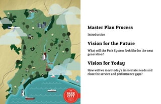
1. Master Plan Process
Introduction
Vision for the Future
What will the Park System look like for the next
generation?
Vision for Today
How will we meet today’s immediate needs and
close the service and performance gaps?
3. Project Schedule
1: Framework 2: Concepts 3: Master Plan
• Kick-off & Stakeholder Interviews • Develop 3 Scenarios • Final Master Plan
• 2011 Parks Inventory • Plan Refinement • Implementation Strategy
• Needs Assessment • Draft Action Plan
• Existing Conditions Analysis • Launch Public Outreach
• Community Survey Development
APRIL MAy JUNE JULy AUGUST SEPTEMBER OCTOBER
Community
Public
Survey
Meeting #1
Public Public
Meeting #1 Meeting #2
#1
Kick Off Client Parks Board Stakeholder Client Stakeholder Client Stakeholder
Review WorkSession Review Worksession Review Worksession
4. Client Leadership Stakeholder Group
• Mayor Bill Finch • Board of Parks Commissioners
• Charles Carroll, Parks Director & Public Facilities Director • Public Facilities-Charles Carroll + Ted Grabarz
• Ted Grabarz, Sustainability Director & Deputy Director of • Parks Manager-Andy Valeri
Public Works
• Recreation Superintendent-Luann Conine
• Steve Hladun, Project Coordinator
• Tree Warden/Urban Forester-Steve Hladun
• Mike Nidoh, Director of Planning
• Planning & Economic Development-Bill Coleman; Donald
• Board of Parks Commissioners: James Brideau, James Giles, Eversley, Director of Planning and Economic Development
Banjed Labrador, Mark Marko, Frank A. Mercaldi, Ann E. Owens,
• Neighborhood/NRZ Coordination-Angie Staltero
Rosa Cruz
• Downtown Special Services District-Rick Myers + Michael Moore
Sasaki • Bridgeport Regional Business Council-Paul Timpanelli
• Historic Preservation Commission-Stuart Sachs
• Jason Hellendrung-Managing Principal
• Small and Minority Business Resource Office-Deborah Caviness
• Gina Ford-Design Principal
• Lighthouse Program, Office of Education and youth-Tammy Pappa
• Brie Hensold-Project Manager, Planner
• Greater Bridgeport Regional Business Council-Brian Bidolli
• Eamonn Hutton-Landscape Architect
• City Council-Lydia Martinez, Martin C. McCarthy, Susan Brannelly,
• Stephen Gray-Urban Designer Denese Taylor-Moye, Anderson Ayala, Robert S. Walsh, M. Evette
Brantley, Howard Austin, Sr., Thomas C. McCarthy, Michelle
Lyons, AmyMarie Vizzo-Paniccia, Warren Blunt, Richard Bonney,
Heller & Heller Angel M. DePara, Jr., Carlos Silva, Manuel Ayala, Richard M.
Paoletto, Jr., Robert Curwen, James Holloway, Andre F. Baker
• Barbara Heller-Parks & Recreation Planner
5. Builds on Foundation of
Existing Plans and Activities
Master Plan of Conservation and Development (2008) BGreen 2020
Waste,
Green Energy Greenfields & Water Businesses
downtown Jobs neighborhoods Education Infrastructure Environment Green Spaces Materials & Marketing
& Buildings Green Wheels resources & Jobs
recycling
New Parks Amenities 2011 Parks
and Improvements Master Plan
New Signage
7 NRZ Plans School Renovations Complete Streets Complete Streets
Policy & Action Plan
Knowlton Park
Main & Gold Pocket Parks “Surprise, it’s Bridgeport”
Black Rock & South End Bike Paths
Community Development
Tennis Courts Save the Sound Green
Block Grant Public Park
Improvements Infrastructure Feasibility Scan
Improvements Program
6. Builds on Community Support
Local Leadership The Neighbors
Board of Groundwork Bridgeport Arts & 34 Seaside Day Hundreds of 80+ people at
Bridgeport BRBC & DSSD
Education Cultural Council Campers survey responses Public Forum #1
2011 Parks
Master Plan
GBRC: BGreen 2020
Mayor’s Parks & Rec. Pequonnock Parks, Water, Fairfield County Trust for
Office Department Parks Board River Initiative, Community Fndn. Public Land
Open Space
Monroe, Trumbull,
Bridgeport Committee
Public Leaders Regional Coalitions
8. Community Survey
Hundreds of online and paper responses
More family-friendly parks and amenties are desired
• playgrounds
• splash pads
• picnic shelters
• swimming facilities
top 3 parks for improvement are large, city parks
1. Seaside
2. Pleasure Beach
3. Veteran’s Memorial Park
9
A little more than half
of households have NOT
participated in Bridgeport rec yeS NO
programs or events in the last
12 months. 54% 46%
Responses from online park system survey
9. Community Survey
Community Survey
Community Survey
10
Community Survey
10
11
1
11
2% 10%
2%
Most residents learned 10% 18% Newspaper
Most residents learned 2% 10% 18% Newspaper
Most residentsParksservices
Most residents & Rec & Rec services
about Parks learned
about learned 18% City of Bridgeport Website
Newspaper City of Bridgeport Website
about newspaper, city web web
via Parks & Rec services Social media (Facebook, Twitter, etc.)
City of Bridgeport Website
aboutsite, and citycity web city
via newspaper,
Parks & rec services
via newspaper, staff. staff. 20% 20%
Social media (Facebook, Twitter, etc.)
Promotional material or flyers
site, and city Social media (Facebook, Twitter, etc.)
Promotional material or flyers
via newspaper, city website,
site, and city staff. 20%
21% From City Staff
21% Promotional material or flyers
From City Staff
and city staff. 21% From friends and neighbors
From City Staff
From friends and neighbors
9% 9% Materials at the Parks and Recreation Department
From friends and neighbors
Materials at the Parks and Recreation Department
9% 6% 14%
6% I have not seen or heard anything about parks services
Materials at the Parks and Recreation Department
14% I have not seen or heard anything about parks services
6% 14% I have not seen or heard anything about parks services
Residents believe park
residents Residents believe park
believe User friendliness of Park of Park District website
User friendliness District website
maintenance and the the
Residents believe park and
maintenance
maintenanceand thethe
quantity of and walking/biking
maintenance walking/biking
User friendliness of Park District website
quantity of QualityQuality of ice rink ice rink
of indoor indoor
quantity of trails most most
trails require the require
quantity of walking/biking
trails require the Number of parks
Quality of indoor ice rink of parks
Number
the most support in next 3-5
support most the
trails require the next 3-5
support in in the Number of parks
years.in the next 3-5 Availability of info about programs/facilities
nextsupportyears.
3-5 years. Availability of info about programs/facilities
years. Availabilityof programs and facilities for adults
QualityQuality of programs and facilities for adults
of info about programs/facilities
Quality of programs andplayground equipment
QualityQuality of playground equipment
of facilities for adults
Youth programs
Quality of playground equipment programs
Youth
Adult programs
Youth programs programs
Adult
QualityQuality of outdoor swimming pools
of outdoor swimming pools
Adult programs
Quality of outdoorwalking/biking trails trails
Quantity of swimming pools
Quantity of walking/biking
Park maintenance
Quantity of walking/biking trails
Park maintenance
Park maintenance 0 100
0 100
0 100
10. Community Forum # 1
August 10, 2011 august 10th at cesar Batalla
assessment of overall Park System 80+ people signed in
Strengths
• Many diverse park types in the system
• Access to water and location on the Long Island Sound
• Special parks like Beardsley Park and Connecticut’s Beardsley Zoo
• Park City – history of park system and large quantity of parks
Weaknesses
• Overcrowded
• Lack of access or transportation options
• Lack of diverse activities, rec centers or recreation program
Highest Priorities
• Maintenance/upkeep/cleaning
• Education
What’s Missing? • Access/access, visibility and safety of parks
• Connection to nature and ecology • Natural resources and protection of habitat
• Education for children and adults • Secure finances so Parks Master Plan recommendations can be
• Safety: lighting needs to be addressed implemented
• Upkeep and maintenance
11. “connEct”
Community Forum # 1 • Streets as connectors to parks
• Enhanced water access
community Feedback on 3 Scenarios
• Like ability to access parks without access
• Stories about how Bridgeport’s future might unfold for its parks
• A method for finding appropriate movements down each path
“EnHancE”
• Big Wins make sense
• School grounds as publically accessible amenities are great
• Durable surfaces and focused programming (ie. Old Mill Green as
a hyperpark)
• Support for pocket parks and enhanced small parks
Refined Plan “EXPand”
• Partnerships and more friends of parks groups
• Support school partnership but requires coordination
• Neighborhood investment would be useful and lead to creativity
• Volunteers are good for parks
• Like funding programs, but responsibility issues surrounding
“sponsored by” parks
13. A Healthy, Connected Future
As the population grows and resources become scarcer, urban centers
like Bridgeport are an essential component of a sustainable society—
and one critical key to livable cities is a successful park system.
Bridgeport’s park system will lead the way by being:
Physically connected
• Envision Bridgeport’s parks as part of a green infrastructure system
throughout the city that keeps people and the environment healthy
• Connect Bridgeport’s signature regional parks to its neighbors
Ecologically diverse
• Celebrate the range of open space types in Bridgeport’s system
• Bring renewed brownfields, vacant lots, and neglected lands back
into the open space system
accessible to all
• Offer more diverse programming
• Improve communications and ensure parks are highly visible
Economically Viable
• Support growing population trends with new parks to serve needs
• Create value for future development
14. CREATE EAST/WEST LINK TO REGIONAL PUBLIC ACCESS ALONG
Physically Connected CONNECTIONS HOUSATONIC RAIL-
TRAIL SySTEM
yELLOW MILL CREEK AND
PEQUONNOCK RIVER
PUBLIC ACCESS UTILIZE RAILROAD PARK AVENUE WATER TAxI ACCESS TO
ALONG ALL CITy AVENUE FOR COMPLETE STREET WATERFRONT
WATERFRONTS CROSS-CITy TRAIL
CONNECTION
15. INCREASE TREE CANOPy RENATURALIZE REHABILITATE
Ecologically Diverse ALONG STREETS THROUGH
TREE PLANTING PROGRAM
LARGE PARKS RIPARIAN CORRIDORS
PROTECT KEy HABITAT AREAS WHILE
PROVIDING PUBLIC ACCESS
16. WEST SIDE II WENT FIELD OLD MILL GREEN SUCCESS PARK
Accessible to All
• OFFER MORE DIVERSE PROGRAMMING
AND IMPROVE SERVICE TO ALL
IMPROVE SERVICE UPCHURCH PARK
• IMPROVE COMMUNICATION AND
TO HIGH NEED BELT
ENSURE PARKS ARE HIGHLy VISIBLE
THROUGH HyPER-PARKS
THROUGH SIGNAGE AND PUBLICATIONS
17. CONTINUE OPERATING FAIRCHILD DOWNTOWN BUSINESSES PARTNER WITH LAKE SUCCESS
Economically Viable WHEELER GOLF COURSE AS PARK STEWARDS ECO-BUSINESS PARK
INCREASE VENDOR ENHANCE WATERFRONT TO PARTNER WITH DEVELOPMENT
OPPORTUNITIES AT STIMULATE GROWTH TO CREATE PARK SPACES
SEASIDE PARK
20. What are the Gaps Today?
• accessibility
• neighborhood Parks
67 NA 203
216 289
86 new Main and Gold mini-park
72
4.4 BPT NRPA SA/HH
BPT NRPA SA/HH
MINI-PARK NeIgHBoRHood PARK
ToTAl AcReAge ToTAl AcReAge Mini
Special Use Neighborhood
distribution
of Park COMMUNITy
286 1,082 26
286 1,082 types
577 577 REGIONAL
291 551
BPT NRPA SA/HH BPT NRPA SA/HH
% of ToTAl AcReAge
coMMuNITy PARK RegIoNAl PARK
ToTAl AcReAge ToTAl AcReAge
21. What are the Gaps Today?
• Play / Family friendly activities
• durable court sports
Play
2
53 1 Longfellow Playground
2 2
19 115 72 1 1 2 3 5 5 1 7 3 1 7 3
BPT NRPA SA/HH BPT NRPA SA/HH BPT NRPA SA/HH BPT NRPA SA/HH BPT NRPA SA/HH
PlAy gRouNdS Ice SKATINg RINK SPRAy PAd INdooR Pool ouTdooR Pool
court Sports
24
1
17
29 29 24 72 48 4 NA 5
11
BPT NRPA SA/HH BPT NRPA SA/HH BPT NRPA SA/HH
BASKeTBAll TeNNIS volleyBAll
Success Park
22. Where is the Need Highest?
Park Need
Population Density
Car Access
Diversity
HIGH
Income LOW
23. What are the Gaps Today?
• Maintenance
• recreation programming / staff
current Staff Size
20
RecReATIoN 3
MAINTeNANce 14 22 47 63
Park System BPT NATL. USUAL STND. BEST
COMPS PRACTICE
1,346 acres
45+ parks
24. How does the plan
meet the need? 2011 Parks
Master Plan
Adding Sustainable Visibility +
5 Strategies Partnerships Amenities
Connections
Maintenance Outreach
25. How does the plan
meet the need? 2011 Parks
Master Plan
Adding Sustainable Visibility +
5 Strategies Partnerships Amenities
Connections
Maintenance Outreach
Examples Schools
Quick Wins Board of
Education
26. Partnerships
We need everyone’s help to keep the parks safe,
clean, active, and living up to the Park city legacy.
46 Parks
& growing
• City-wide parks
• NRZ neighborhood adopted
parks
• Downtown parks
• Key natural resource parks
• Shared school parks
• New hyper parks
• Small or specialized parks
27. • Stewards major city and regional parks
• Protects the Olmsted Parks legacy in Bridgeport
city • Provide large, diverse park offerings for citizens
*
• Seeks revenue-generating opportunities *
Beardsley
Seaside
Fairchild Wheeler Golf course
F.W. Golf course provides
city revenue
$2.5 M
$2 M
$1.5 M
$1 M GOLF COURSE
*
0.5 M
0 OTHER
Protect the Legacy -
2005
2006
2007
2008
2009
2010
2011
ToTAl ANNuAl ReveNueS
3 olmsted Landscapes
28. • “Adopt” a neighborhood park
nrZ • Contribute ‘sweat equity’, improvements,
daily care and stewardship
• Pursue official non-profit organization status
or partner with neighborhood non-profit
Boston Ave/Mill Hill Manilla Park
Black Rock Ellsworth Park
Brooklawn/St. Vincent Alice St. Lot Washington Parks & People , Washington dc
Downtown Baldwin Plaza
East End Newfield/Jessup
East Side Washington Park
Enterprise Zone NO PARKS
The Hollow Lafayette Park
North Bridgeport Beardsley Park
North End Puglio Park
South End Seaside Park (shared)
West Side McGovern Park
Whiskey Hill Glenwood Park
29. • Sponsor a highly visible downtown park
down- • Work with DSSD, BRBC, and the City on
town programming and events
• Integrate public art and coordinate with
Bridgeport Arts and Cultural Council and
local arts organizations
Waterfront Park New Main and Gold pocket park
McLevy Green Farmer’s market
Wheeler Park Majestic Park
Broad Street Steps Baldwin Plaza
McLevy Green City Hall Annex Park
Jackson Square, nyc
30. • Support city by initiating conservation initiatives
(Save the Sound’s Green Infrastructure Feasibility
nature Scan and the Pequonnock River Initiative)
• Help organize volunteer efforts
• Incorporate education and community outreach
into activities
Pleasure Beach
Fairchild Memorial Park
Elton Rogers Park
Pleasure Beach (c Emmett unlimited)
Veterans Memorial Park
Vacant lands and future community gardens
Already active in this area:
Save the Sound
Connecticut Audubon
Groundwork Bridgeport
Ash Creek Foundation
Volunteer clean-ups
31. School yard amenities
Schools • 216 acres of park space
• Playgrounds - 31 playgrounds
# leISuRe AcTIvITIeS
# PlAy fAcIlITIeS
• Basketball - 15 courts
# couRTS
# fIeldS
• Baseball - 8 diamonds
• Football / Soccer - 9 fields
Sources: http://www.bridgeportedu.com/schools/Schools%20Elementary.html and Google Earth
amenities in Schools today Waltersville/Barnum School contains 2 courts and play facilities
34. School Partnerships
Schoolyards to Playgrounds, new york ny
• Supports 10–minute walk for all to a park or playground.
• 258 schoolyards will open by 2013.
• Open after school, on weekends, and during breaks.
• Parks Department, the Department of Education (DOE), and
Trust for Public Land (TPL) are working together to improve 161
of the 258 schoolyards.
• NyC is investing $95 million for playground improvements
PARTNERSHIP OF PARKS DEPT, DEPT OF EDUCATION, AND THE TRUST FOR PUBLIC LAND • The 258 sites will be maintained by the DOE.
SCHOOLyARDS OPEN DURING OFF-HOURS
35. Board of Education
Johnson oak + tisdale School
• Reconfigure layout and circulation so that public park zone is
accessible off of main streets
• Allow public use of the school area during agreed non-school
s
cces hours
ify a
clar
• Shared maintenance and security through partnerships of Parks
Department, school security, neighbors and police
accessible public area
Secured school area
Proposed future
conditions diagram
PoPuLatIon Johnson oak Park
0 25 50 100 200
36. How does the plan
meet the need? 2011 Parks
Master Plan
Adding Sustainable Visibility +
5 Strategies Partnerships
Amenities
Connections
Maintenance Outreach
Examples Schools Hyper Parks
Quick Wins Board of Success Park
Education synthetic field
37. Where do we add amenities?
Hyper-park Program
old Mill Green Success Neighborhood
Population
upchurch/James
Brown Waterview Need by Neighborhood
Went Field
West Side II
Amenities Deficit
Physical Potential
38. Where do we add amenities?
Hyper-park Program
old Mill Green Success
Centrally Located
upchurch/James Accessible to all
Brown Waterview
Went Field
West Side II
Distinctive Identities
Durable + Highly
Programmed
destination Playground
39. reet
ain st
east m north Bridgeport/East Side
t
Old Mill Green
e
re
st
m
y lu
rt as • Under programmed space
.1
• Limited pedestrian access
• High maintenance mowed surface
east main street
e street
rt
.1
pembrok
40. reet
ain st
east m north Bridgeport/East Side
t
Old Mill Green
e
re
st
m
y lu
rt as • Increased amenities including 8 tennis courts, skate park, dog run,
.1
PReSeRve HISToRIc playground, and historic park
TReeS ANd MARKeR
PlAzA
• Close 2 streets for pedestrian safety (North Hallett and Goddard)
SKATe PARK • Historic, shaded open space serves as gateway to the park
• Traffic calming through improved and increased number of
crosswalks to improve pedestrian access
IMPRoved cRoSSwAlK
AT TRAffIc SIgNAl • Builds on adjacent Fire Department and Parent Center resources
60,000 Sf deSTINATIoN fIRe dePT AcceSS
PlAy gRouNd ANd PARKINg
PlAzA
8 TeNNIS couRTS
putnam street
east main street
dog PARK
e street
rt
.1
pembrok
0 100 250 500
41. East Side
crescent ave Upchurch and James Brown
• Unrealized potential connection betrween parks
• Potential partnersip with school and housing authority
• Limited connection to yellow Mill Creek
treet
hallett s
eek
cr
ill
wm
lo
yel
42. HouSINg AuTHoRITy
develoPMeNT SITeS
East Side
eNvIRoNMeNTAl
educATIoN PlAy AReA
crescent ave Upchurch and James Brown
• Gateway to the yellow Mill Creek Corridor
• Waterfront path and internal trail circut
• 2 destination playgrounds:
1. Educational and environmental focused waterfront play
treet
2. Neighborhood play & recreation zone
hallett s
couRTyARd/
coNNecTIoN
PAvIlIoN
oN-STReeT
PARKINg
P TRAIl
coNNecTIoN
BARNuM
ScHool cRoSSwAlKS
wAlTeRSvIlle
exISTINg
eek
couRTS
P
cr
ill
wm
lo
yel
RevITAlIzed
PoPuLatIon
PlAyfIeld
TRAIl To jAMeS BRowN PARK ANd
ecologIcAl ReSToRATIoN AReA
TeNNIS couRT 0 100 200 400
exISTINg
BASKeTBAll couRT
43. Boston ave/Mill Hill
cou
rt D Success Park
• Backed by housing
eet
• Limited visibility
r str
• Field in poor condition
rbo
l ha
pear
Gra
nFie
lD a
ve
44. co
ur
Boston ave/Mill Hill
t
D
RAIN gARdeN
Success Park
• Synthetic turf play field planning already underway by City
25,000 Sf deSTINATIoN
eet
PlAy gRouNd • New through road provides better access, visibility, and overall
r str
BuffeR PlANTINg neighborhood connectivity
rbo
eNTRy • 2 basketball courts, 1 tennis court, synthetic turf, and destination
l ha
SIgNAge
playground
pear
New coNNecTIve
RoAd
2 BASKeTBAll
PAvIlIoN ANd
couRTS
PIcNIc AReA
New TeNNIS couRT SyNTHeTIc TuRf
PlAy fIeld
ReSToRed exISTINg
TeNNIS couRTS
P
eNTRy SIgNAge Gra
nFie
lD a
ve
PoPuLatIon
0 25 50 100 200
45. How does the plan
meet the need? 2011 Parks
Master Plan
Adding Sustainable Visibility +
5 Strategies Partnerships Amenities
Connections
Maintenance Outreach
Complete
Examples Schools Hyper Parks
Streets
Quick Wins Board of Success Park Pleasure Beach
Education synthetic field fishing pier
46. Connections
restore ecological connections and amplify the Pequonnock and yellow Mill
transform bare infrastructure through plantings and green infrastructure
complete Streets and reinforce walkability to parks
47. Build on current initiatives
Progress at knowlton Park along the Pequonnock river new sidewalks improve walkability at Seaside
51. Greenway Partnership
Mill river Park and Greenway, Stamford ct
• The channelized Mill River runs through the center of Stamford.
• In 2002, Mill River Collaborative was formed.
the Mill river collaborative
• Initiated by Stamford Partnership, City of Stamford, Urban
Redevelopment Commission and Trust for Public Land.
• A 501c3 non-profit corporation
STAMFORD’S MILL RIVER PARK URBAN GREENWAy • Many partners contributed to its success.
2009 Financial Partners
33 Broad Street Associates II, LLC SLGreen
Boehm Family Foundation Robinson & Cole
Bridger Management Robyn Rubinstein Memorial Fund
Carlson Family Foundation S L Green Management
Cummings & Lockwood Charitable Fndn Samuel Lotstein Realty Company LLC
Fairfield County Community Foundation Selkowitz Family Foundation
First County Bank Foundation, Inc. The Edith & Herbert Lehman Foundation
GE Asset Management The Insurance Exchange
General Reinsurance Corp The Malkin Fund
Greenwich Capital Markets, Inc. The Trust for Public Land
Melissa Anne Leonhardt Fund The Velaj Foundation
Overbrook Foundation UBS AG
Pitney Bowes Employee Involvement Fund W&M Properties of CT, Inc.
Pitney Bowes Foundation William & Sylvia Silberstein Foundation, Inc.
Purdue Pharma L.P. xRAM LTD
RBS Securities
yELLOW MILL CREEK TODAy
53. How does the plan
meet the need? 2011 Parks
Master Plan
Adding Sustainable Visibility +
5 Strategies Partnerships Amenities
Connections
Maintenance Outreach
Complete Naturalized
Examples Schools Hyper Parks
Streets Landscapes
Quick Wins Board of Success Park Pleasure Beach Ash Creek
Education synthetic field fishing pier Enhancements
54. Sustainable Maintenance
• Seek big wins by focusing first on the large parks
• Renaturalize the edges and “roughs” of large regional parks
BeARdSley PARK
• Renaturalize small, underutilized parks to minimize mowing
181 acres
• Low-maintenance vacant lots/community gardens program
Large Parks - Beardsley, Seaside, F.W. Golf course
underutilized - Manila Street, Majestic, West End
Undeveloped
635 Park Space
1,346 Total
Park Acres
711 Developed
and
Maintained
SeASIde PARK Park Space
370 acres
308 210
developed Parks WHAT 17 FULL-TIME
STAFF MAINTAIN IN
WHAT 17 FULL-TIME
STAFF TyPICALLy
WHAT BEST MANAGEMENT
PRACTICES RECOMMEND
BRIDGEPORT MAINTAIN FOR 17 FULL-TIME STAFF
55. Sustainable Maintenance
Greener Management in Bridgeport Means:
• Renaturalize 180 acres total - 25% of Beardsley, Seaside, and
Golf Course
• Potential operations savings of $1,005/acre vs. traditional
landscape or $180,900 annually in operations costs*
• Savings can result from staff time, equipment, and materials
• Upfront costs for conversion from turf followed by longterm
savings
Benefits
• Introduction of native plants
• Restoration of former habitat
• Enhanced biodiversity
• Reduction of carbon impact from mowing and maintenance
*Potential savings estimated based on current Bridgeport parks spending and maintenance
practices in Bridgeport, and case studies of similar changed landscape managment practices.
56. Sustainable Maintenance “Managing and maintaining a man made
landscape is anything but natural.
training & new Skillsets
We have to cut the lawns, fertilize the
• Restoration ecology techniques
trees, water the plants and spray for
• Awareness of new landscape types
diseases and pests.”
• Education among staff and community
- Buffalo Olmsted Conservancy
Minneapolis Parks & recreation Board
• Natural areas converted to prairie grasses, storm water ponds and
shoreline buffers
• Management standards:
» Athletic Field - Maintained daily to weekly, grass height of 2.5 to
3”. Potential for durable astroturf
» General Park Turf Maintenance - Maintained on a less frequent
basis. Grass height can exceed 5” at times.
» Reduced Mowing in Natural Areas - Maintained on an
infrequent basis.
Buffalo olmsted conservancy
• Goal to convert 20% of each park to maintained meadow areas.
• Meadows contain native plants and are mowed 1-2 times per year.
57. Sustainable Maintenance
Vacant Lots
• Potential for new park space on lots larger than 1 acre
• Small scale productive landscapes and community gardens
N
o
gT
vIRgINIA Ave
N
TI
uN
H
Large vacant sites provide the opportunity to introduce new parks to the system, while the integration
of durable, sustainable systems will help minimize impact on maintenance operations.
Vacant Lots
59. How does the plan
meet the need? 2011 Parks
Master Plan
Adding Sustainable Visibility +
5 Strategies Partnerships Amenities
Connections
Maintenance Outreach
Complete Naturalized
Examples Schools Hyper Parks
Streets Landscapes
Parks Guide
Quick Wins Board of Success Park Pleasure Beach Ash Creek
Parks Map
Education synthetic field fishing pier Enhancements
60. Visibility & Outreach “Bridgeport has a great story to tell, and it
• Improved Parks and Recreation Department website needs to get out there,” Curtatone said.
• Branded, consistent wayfinding and signage
In Somerville, we’ve implemented a
• Enhanced Recreation program offerings
branding plan because we’re still fighting
• Recreation program guide and “parks passport”
generations of negative perceptions.”
- Mayor Joe Curtatone, Somerville, MA
61. Recreation Program Guide
Connect with the Park City
Watch For More The Curtain Rises at
Reservoir
Indoor Programming Bijou Theater
North End Whiskey Hill Puda sequi velistrunte adis et et qui iliqui volesto tatur, sit Puda sequi velistrunte adis et et qui iliqui volesto tatur, sit
fuga. Omnihilit, quati alias nus, quam illigenda volorem fuga. Omnihilit, quati alias nus, quam illigenda volorem
eossed moditae stotation parisit qui rem. Et aribusciur? Os eossed moditae stotation parisit qui rem. Et aribusciur? Os
aut quo bearum hilique molectio blaboris est, sam asitatur aut quo bearum hilique molectio blaboris est, sam asitatur
reperib uscipsam vel exceaque por aut qui consequam ut reperib uscipsam vel exceaque por aut qui consequam ut
eossed experorae sus repera sus et iducitatur si corpor eossed experorae sus repera sus et iducitatur si corpor
North Bridgeport aliquo volor sequodio que reribus eatis. aliquo volor sequodio que reribus eatis.
Ga. Si odi rentibus. Aximagnis ut ra prata veliti odissi que Ga. Si odi rentibus. Aximagnis ut ra prata veliti odissi que
ommolor eptur? ommolor eptur?Cia voluptaerum doluptatur, et eni comnihil
Amazing Art with the
Brooklawn/
St. Vincent Enterprise Boston Ave/ Dogs In The Parks Bridgeport Arts + Cultural
Zone Mill Hill
Puda sequi velistrunte adis et et qui iliqui volesto tatur, sit Ipsam, si ommoluptat. Dicipsant, simi, oditect atemodion
fuga. Omnihilit, quati alias nus, quam illigenda volorem pro core poreni rem eos volessi mporionsedi sit ata et
East Side eossed moditae stotation parisit qui rem. Et aribusciur? Os ommoloresci optatem eos erspidios experum vendus et
The aut quo bearum hilique molectio blaboris est, sam asitatur dolum im as non num utatusam, quo quas dolum nobitem
Hollow reperib uscipsam vel exceaque por aut qui consequam ut hicimus est asperferia nonetus, cum fuga. Ut volumquis et,
East End eossed experorae sus repera sus et iducitatur si corpor quiassin nos expedignis unt pelest repudit aut eossunto
aliquo volor sequodio que reribus eatis.
quam fugit, si sequi ut harum ipsae quam, ilite comnis
West End/
Downtown Ga. Si odi rentibus. Aximagnis ut ra prata veliti odissi que voluptatur? Quiae consed magnis di volor autatis eatem
West Side ommolor eptur?Cia voluptaerum doluptatur, et eni comnihil facersp eribus ab il explign aturemo lesserunt esti illabore
ipsam ipis ent rescia volenem as verum si dolores ulparciunt suntia dus videndit doluptust, cullabo ressinciis sunt
omnimpos ea dolorupitem aute pos etur, conecuptatia volor repudis ulpa dit omniscia di il id est officip sundae
South End
Olympic Athlete to Improved Training For
Visit Seaside Camp Volunteer Coaches
Black Rock Puda sequi velistrunte adis et et qui iliqui volesto tatur, sit Dame sitis il ipit fugitatquis et volor aut facest, sa dolendam
fuga. Omnihilit, quati alias nus, quam illigenda volorem es errum incillabore nonsequatem fuga. Inullore repe
eossed moditae stotation parisit qui rem. Et aribusciur? Os volorion etur ma vel molupti untoressit inum quatque officim
aut quo bearum hilique molectio blaboris est, sam asitatur usciae sin cum int aut optio. Bitiam, sollit, commos qui
THE reperib uscipsam vel exceaque por aut qui consequam ut odi idusciis et fuga. Ucia dunt, incto modis qui odit utem
eossed experorae sus repera sus et iducitatur si corpor latur sa quodis aut faciaspis doluptur, sitae quationseque
PARK aliquo volor sequodio que reribus eatis. ratus modis ma voluptas am sum qui re labo. Ceaquae
plaboria velit et aperia dendae. Ad et, sitatibus res verumqu
CITYA Parks Master Plan for
PROGRAM GUIDE
Ga. Si odi rentibus. Aximagnis ut ra prata veliti odissi que
ommolor eptur?
asperibus esedit ant.
Quatque everorpos si nullam esequib eribusantia pores
Bridgeport
Connecticut
62. Park City Park System and
Amenities Map
• Coordinate with Greater Bridgeport Transit maps
• Link to future bike and complete streets maps
• Inventory provides families, downtown employees, and athletes
with information about walkable playgrounds, event locations, and
recreation training facilities
63. “Park City Passport”
• Incentives program to encourage residents and visitors to visit all
of Bridgeport’s parks
• Users receive a “stamp” in their parks passport
• Enhances visibility, awareness, and appreciation of the park system
Washington Park
Puda sequi velistrunte adis
et et qui iliqui volesto tatur,
sit fuga. Omnihilit, quati alias
nus, quam illigenda volorem
eossed moditae stotation
THE parisit qui rem. Et aribusciur?
PARK Os aut quo bearum hilique
molectio blaboris est, sam
CITY PASSPORT asitatur reperib uscipsam
vel exceaque por aut qui
A Parks Master Plan for
Bridgeport
Connecticut
Place Stamp Here
64. 2011 Parks
Master Plan
Adding Sustainable Visibility +
5 Strategies Partnerships Amenities Maintenance
Connections
Outreach
Naturalized Complete
Examples Schools Hyper Parks
Landscapes Streets
Parks Guide
Board of Success Park Ash Creek Pleasure Beach
Quick Wins Education synthetic field Enhancements fishing pier
Parks Map
Funding CDBG Grants & EPA and Federal Corporate and
Foundations and State Downtown
Sources Public Private Brownfield
and Nonprofits Transportation Sponsorships
Partnerships Grants
65. What’s Next for the
Park City & How Can
You Help?
Visit http://www.bridgeportct.gov/
66. Parks Standards
Reservoir
North End Whiskey Hill
North Bridgeport
Brooklawn/
St. Vincent Enterprise Boston Ave/
Zone Mill Hill
East Side
The
Hollow
East End
West End/
West Side Downtown
South End
Black Rock
THE
PARK
CITYA Parks Master Plan for
PARKS STANDARDS
PROGRAM GUIDE
Bridgeport
Connecticut
67. Partner
nature/
neighborhood city / Government nrZ Private Schools conservation
High
Boston ave / Mill Hill
Success Park Hyper Park
East End
Johnson oak Park Hyper
Park
Pleasure Beach
improvements
rail trail/ Linear Park
East Side
the Hollow
South End
West End / West Side
Moderate
Whiskey Hill / reservoir
Brooklawn / St. Vincent
downtown
Black rock
Low