This is how i have envisioned the implementation of the community based tourism package ( SCR 6.1) to be implemented in my state through the funding of ADB. The presentation gives you a clear cut idea on what is community based tourism m how we are planning to implement it in Himachal through PRA tools and the areas that we have selected for the skill based training of which will be given to the communities in the identified clusters. These inferences have been drawn from my experiences working in following areas & organizations -
- Great Himalayan National Park in Himachal Pradesh
-Annapurna Conservation Area in Nepal
- Sikkim Biodiversity & Conservation Project
-Surya-Abha Society Ladakh
-Directorate of Mountaineering & Allied Sports , Manali
-Government Post Graduate Degree College Kullu
-The Kullu Project
-Sunshine HImalayan Adventures , Kullu
Yas Island
Benoy , firm of award-winning architects and planners, designed a concept masterplan for one of the world’s largest and most prestigious mixed-use destinations, Yas Island in Abu Dhabi.
Asymptote Architects designed Yas Hotel,
The principal architects of Asymptote were Hani Rashid + Lise Anne Couture
If you own a business of event management then build a powerful presentation for your business through our event management PowerPoint presentation slides which helps in describing the important aspect of your business to your potential audiences such as business investors and sponsors. Thus, make use of this PowerPoint layout to describe event management planning for making your event a success with all your efforts and measures. This PPT image can also be used by business other than event management companies to prepare a document for managing a particular event in the business-like event of launching a new product or service, event of new marketing campaign for the business and many more. Thus, this event management PowerPoint is all in one solution for the associations to monitor or plan their business events idea’s effectively with this PowerPoint template. Just click and start documenting your ideas into words or graphics with this exceptional Presentation design to create an exquisite business PPT design. Attempt a fresh approach with our Event Management Powerpoint Presentation Slides. They embolden you to experiment. https://bit.ly/3AuASao
TOOL FOR IMPLEMENTING HAITI’S STRATEGIC DEVELOPMENT PLAN: 2014-2016 THREE-YEA...Stanleylucas
PARDH served as a guide for government authorities and international partners, so that a series of urgent measures and key projects could be carried out to put Haiti on the path of change, to ensure that it will be an emerging country by 2030. At the same time, the national authorities developed a Strategic Development Plan for Haiti, to provide further details on the PARDH guidelines and include all public policies in a consistent global package, as a single programming approach.
The Haiti Strategic Development Plan presents the new framework for the planning, programming, and management of Haitian development, the vision and the strategic guidelines for the country’s development, the four major work areas to be implemented to ensure the recovery and development of Haiti, the programs and subprograms to be implemented under each of them, and the major features of the implementation strategy. These choices are designed to make Haiti an emerging country by 2030, and testify to the clear intention of the authorities to seek a balanced, sustainable development that will guarantee and maximize the impact of the programmed activities. This approach will apply to the next three years covered by this document, which presents the three-year development program and the three-year investment program, the first tools for implementing the PSDH.
The first part of this document contains the three-year development framework. This framework is aimed specifically at accelerated, balanced economic growth and the sustainable reduction of poverty. It shows the road map the government will follow during the period to remain on target. It is also the vehicle to be used by the government to implement its activities, which have clearly formulated results indicators.
The second part of the document presents the 2014-2016 Three-Year Investment Program. More specifically, it lists the projects to be implemented. The projects chosen are a continuation of the following: recent action undertaken to begin the reform and reconstruction of Haiti; action carried out earlier under the National Growth and Poverty Reduction Strategy Paper (DSNCRP) to reduce poverty and social
Challenges faced in emergency response phase in urban areasAshique Hasan
The world is now facing a rapid growth of urbanization mainly in Asia, Africa and Latin America. Now the time has come to give more attention to urban people as the humanitarian agencies faced lots of difficulties in emergency response phase in urban areas. And some of the difficulties are very challenging and uncommon compared to rural areas. The uncontrolled urbanization due to unexpected migration towards urban areas is one of the underlying causes for that. Beside these lack of good governance and peoples accountability also responsible for stimulating the migration process towards urban areas. This paper tries to focus the causes of migration. And how it turns into hazard in urban perspective and create difficulties for the humanitarian agencies job during emergency response phase. Basing on case study of Haiti and Chile earthquake this paper highlights the gaps and limitation of the government’s disaster plan and following with some recommendations.
2013 American Institute of Architects (AIA) National Convention keynoteCameron Sinclair
This is the keynote presentation presented by Cameron Sinclair at the AIA National Convention in Denver, CO on June 21, 2013. Watch the livestream at http://www.ustream.tv/recorded/34714049
Switchyard Park Master Plan | Inventory PhaseSwitchyardPark
As the initial step in the master plan process, the Switchyard Park Master Plan team conducted a thorough inventory of the site, its surroundings and those factors that might influence its development.
The purpose of the inventory phase was two-fold. First, it is essential to understand the physical, environmental, ecological, social, economic and development influences of the site in order to develop a concept for the park that will function efficiently and effectively at each stage of its development and use.
Equally important is the need to understand in detail the cultural characteristics, history and significance of the site. Discovering these distinctive qualities of place and celebrating them through imaginative design will result in a community park that is unique to Bloomington.
Manhattan Kansas Bicycle Master Plan Revisionmwesch
Presented at the February 23rd Bicycle Advisory Committee meeting in Manhattan, Kansas. The presentation presents an update to the 1998 Master Plan, recommending that we focus more on the 60% of potential riders who are "interested but scared" by creating a low-traffic, low-speed "green grid" for bicycle commuting.
Architecture and Town Planning _Unit 6_SPPU_Spacial Township, SEZ, CRZ, Smart...Shrikant Kate
Savitribai Phule Pune University
Board of Studies in Civil Engineering
B. E. Civil 2015 COURSE (w. e. f. June 2018)
401004 Elective I (4)- Architecture and Town Planning
Architecture and town planning _Unit 3_SPPU_Spacial Township, SEZ, CRZ, Smart City, AMRUT, GIS, GPS and RS in Planning by S. R. Kate
Unit VI:
• Special townships, SEZ, CRZ, Smart City, AMRUT Guidelines
• Application of GIS, GPS, remote sensing in planning.
The global offshore decommissioning market is to increase from US$ 7,365 million in 2020 to US$ 9,823 million by 2025 with a compound annual growth rate (CAGR) of 5.9% for the period 2020-2025. Some of the prominent players in the offshore decommissioning market are Aker Solutions Asa, Allseas Group, Baker Hughes Company, Deepocean Group, John Wood Group Plc, Petrofac Ltd. , Ramboll Group A/S, Royal Dutch Shell Plc , Schlumberger, Weatherford International Plc. The research report on the global offshore decommissioning market provides extensive competition analysis and competitive conditions. The report includes information on significant products, players, challenges and developments, and other information specific to the offshore decommissioning market. The global economy is highly affected by the COVID-19. Various sectors in the economy are much affected by this pandemic. It is anticipated that the global economy will decline because of the loss of trillions of dollars. The growing extension and imposition of lockdown in various countries directly affect the economy all over the world. The report consists of a chapter that provides a detailed study of the impact of COVID-19 on the offshore decommissioning market. The data in this report is targeted for business and industry practitioners and specifically intended to assist in the explanation, direction, and to understand the potential of the offshore decommissioning markets. The study focuses on providing readers with an understanding of developments in the industry, market segments, market forecasts, leading players, and market drivers and inhibitors.
As professional architect with an excellent record of success, I am seeking a position at a multi-national architectural practice that would utilize my expertise in Architectural Design and Urban Planning.
I always strive to bring & implement innovative approach to both architectural and interior projects. Excellent at developing technical design drawings. With sustainability in mind through the design process I help my clients to achieve their goals through my extensive architectural background across multi-scale projects.
Similar to Cotes-de-Fer Master Plan / Haiti Tourist Development Project (20)
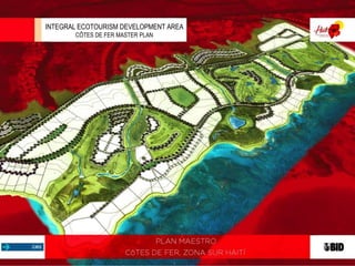
Le Plan de Développement de l'Ile-à-Vache est en marche. Cliquez ici pour vis...Stephanie Villedrouin
L’Île à Vache, localisée au large de la côte sud-ouest d’Haïti à une vingtaine de kilomètres de la ville des Cayes, est identifiée par le gouvernement comme l’un des sites importants de développement touristique. L’île s’étend sur 3,2 km de largeur et 15 km de longueur et compte une population d’environ 15 000 habitants répartis en 26 localités à travers l’île. On y trouve plus de 20 plages, des paysages montagneux, des forêts de mangroves et une économie basée sur la pêche artisanale, l’agriculture et l’élevage.
There would be no future Destination Jacmel if it were not for the past that shaped its landscape and left a rich and textured patrimoine, the ever-present history and colonial buildings whose doors stand ready to open today. Aiyti, land of tall mountains and Jakmèl, its southern coastal capital, have been home to Taino, Spanish, Africans and French, a stage for Toussaint Louverture and Alexandre Pétion, and a fertile ground for tobacco, cane, sugar, indigo, cigars, coffee...and a multi-faceted artistry that expresses itself with startling originality in every medium.
Île à Vache, an island just off the southwest coast of Haiti 30 minutes from the town of Les Cayes, is a true treasure. Just 3.2 km. wide and 13 km. long, it is a virtually undeveloped place with some 10,000 inhabitants, more than 20 beaches, a landscape of mountains and mangrove forests, an artisanal fishing economy and a history
that includes hosting Sir Henry Morgan, one of piracy’s most successful practitioners. Reefs and shipwrecks line the waters offshore.
2. 2
I. Transportation
II. Location
III. Master Plan
i. First Phase
IV. Beach Photographies
V. Target Image
INDEX
3. 3
HAITI
ACCESIBILITY
AIR ACCESS
Air Transportation Actually
Haiti has its air transportation
through the Port au Prince
international Airport and two
other national airports located
at Les Cayes and Jacmel, the
last one is under renovation
by now.
ROAD TRANSPORTATION TO THE SOUTHERN
REGION
The National Route RN2, a two-lane paved
highway, brings connectivity to the southern
region.
The regional road RD23, a four-lane unpaved
highway provide a regional connectivity tu the
area.
SEA TRANSPORTATION
Puerto port has
highest activity in the country.
The facilities include
cranes, large docks,
warehouses, among others.
I
Zona Sur
RD23
RN2
Zona Sureste
Jacmel
Port Salud
PORT AU PRINCE INTERNATIONAL AIRPORT
Muelle
Jacmel Port Salud
Distance Table to Major Cities (Km)
Cotes de Fer
Baleine
Bainet
Aquin
Jacmel
Jeremie
Les Cayes
Miragoane
Petit Goave
Port au Prince
Cotes de Fer
Baleine
Bainet
Aquin
Jacmel
Jeremie
Les Cayes
Miragoane
Petit Goave
Port au Prince
33
33 46
27 40 85
59 97 142 156
195 183 228 155 311
105 93 138 56 241 99
83 71 116 44 112 199 100
109 97 142 70 86 225 126 26
190 178 223 138 121 293 194 94 68
CÔTES DE FER MASTER PLAN, HAITI S SOUTHERN REGION
4. Sitio
Cotes de Fer
Baleine
Bainet
Aquin
Jacmel
Sitio 0
Cotes de Fer 22
Baleine 10 30
Bainet 24 33 14
Aquin 27 27 37 51
Jacmel 55 33 65 79 156
Les Cayes
Port Salut
Port au Prince
Les Cayes 80 102 90 104 56 241
Port Salut 107 129 117 131 44 112 100
Port au Prince 165 187 175 189 138 121 194 94
PM
4
PROJECT AREA
TRANSPORTATION - LOCATION
AIR TRANSPORTATION TO THE PROJECT
According to the International Civil Aviation Organization
(ICAO) standard, they have been analyzed different
location proposal surfaces for the international airport
project (Côtes de Fer).
The analysis result brought out three main options for the
airport location;; once the project has the topography
information, it would be possible to determine its viability.
LOCATION
The project is located at the middle way of the the Port
Salut-Jacmel tourist corridor.
The RD23 highway improvement has been taken in
account, the suggestion is to undertake a two-way four-
lane highway with one-sideway each lane and a median
strip.
Route Table Proposal Section RD23
II
1
3
2
Master Plan Cotes de Fer Route RD23
Junction Route RN2
Jacmel
Port Salud
South
RN2
Southeast
Distance Table to the Master Plan (KM))
CÔTES DE FER MASTER PLAN, HAITI S SOUTHERN REGION
5. 5
MASTER PLANIII
The project is distributed in 5680.95 acres (2299 ha) the 55% may be developed. The
potential capacity is about 7,768 rooms, 12,190 tourist residences, 746 panoramic tourist
residences and 3,077 housing lots. Density: 21 tourist residences per hectare and 83
houses per hectare.
CÔTES DE FER MASTER PLAN, HAITI S SOUTHERN REGION
HOTEL ZONE
COMMERCIAL AREA JOINT HOTEL ZONE
HOTEL ZONE COMMERCIAL AREA JOINT
WETLAND 3
WETLAND 2
WETLAND 1
RESIDENTAL AREA OVERVIEW
URBAN LIVING
EQUESTRIAN CLUB
RESIDENTIAL AREA HOMES AND
CONDOS
RESIDENTIAL AREA HOMES AND
CONDOS
CONDOMINIUM AREA
CONDOMINIUM AREA
HOTEL ZONE
COMMERCIAL AREA
JOINT
CONDOMINIUM AREA
CONDOMINIUM AREA
BEACH CLUB
BEACH CLUB
BEACH
CLUB
RESIDENTAL AREA OVERVIEW
VISTA GENERAL
RESTORATION OF RUNOFF
SERVICIOS
TURÍSTICOS
CONDOMINIUM AREA
Boutique
Hotel
RESTORATION OF RUNOFF
GOLF AND DEVELOPMENT
OF REAL ESTATE
GOLF AND DEVELOPMENT
OF REAL ESTATE
GOLF AND DEVELOPMENT
OF REAL ESTATE
6. 6
MASTER PLAN
FIRST PHASEIIIi
Capacity: 1,266 rooms and 1,133 tourist residences
VISTA PANORÁMICA bVISTA PANORÁMICA a
AERIAL VIEW 1
AERIAL VIEW 2
CÔTES DE FER MASTER PLAN, HAITI S SOUTHERN REGION
HOTEL ZONE
WETLAND 1
CONDOMINIUM AREA
H
BEACH CLUB
RESTORATION OF
RUNOFFS
EQ-T
COMMERCIAL AREA JOINT
URBAN LIVING
CONDOMINIUM AREA
Boutique
Hotel
GOLF AND DEVELOPMENT
OF REAL ESTATE
INVESTMENT TOTAL PHASE 1 (AMERICAN DOLLARS)
EXPENSES
Equivalent investment
for First Phase
Equivalent Investment
for urban living
TOTAL INVESTMENT
FIRST PHASE
MANAGEMENT 661,173.58 436,624.06 1,097,797.64
Permits, Licenses and Concessions 661,173.58 436,624.06 1,097,797.64
STUDIES AND PROJECTS 1,408,230.60 929,963.60 2,338,194.20
Stuides Water Prospecting 281,646.12 185,992.72 467,638.84
Environmental Impact Studies 281,646.12 185,992.72 467,638.84
Banking Study Materials 155,136.97 102,448.94 257,585.91
Soil Mechanics and Pavement Design 281,646.12 185,992.72 467,638.84
Programs and Plans 408,155.27 269,536.50 677,691.77
EXECUTIVE PROJECTS 1,132,583.42 747,932.45 1,880,515.87
Executive Projects Integral Urban Design 393,841.36 260,083.92 653,925.28
Executive Projects Drinking Water 235,704.92 155,654.19 391,359.12
Sewerage Project Executive 204,077.64 134,768.25 338,845.89
Executive Projects Electric Power and Telecommunication 298,959.50 197,426.08 496,385.58
HEAD WORKS 8,025,877.55 5,930,883.71 13,956,761.26
Power generation, Electrical Substation and Tranmission
Lines 3,609,782.10 2,383,818.37 5,993,600.47
Drinking Water 2,558,810.86 1,689,780.76 4,248,591.61
Wastewater Treatment Biodigesteres water treatment
systems or other. 1,857,284.59 1,857,284.59 3,714,569.18
Integral Development 15,840,266.67 11,606,546.34 27,446,813.00
Secondary and tertiary roads 1,374,983.74 1,854,237.85 3,229,221.59
Acces Boulevard 2,162,132.82 4,530,247.69 6,692,380.51
Electric Power Networks and Telephony 3,422,616.11 2,260,218.19 5,682,834.30
Red water, Sewerage and SUDS 2,558,810.86 1,689,780.76 4,248,591.61
Walkers, Squares and Gardens 1,926,265.10 1,272,061.86 3,198,326.95
Environmental Protection Works 4,395,458.03 0.00 4,395,458.03
WORK SUPERVISION WITHOUT GOLF 2,393,187.39 1,580,406.76 3,973,594.15
GOLF COURSE 18 HOLES 14,400,000.00 0.00 14,400,000.00
Golf Course 18 holes 14,400,000.00 0.00 14,400,000.00
Grand Total 43,861,319.20 21,232,356.93 65,093,676.13
NOTE: THESE FIGURES NOT CONSIDER ACQUISITION OF LAND, PREOPERATING EXPENSES OR CAPITAL EXPENDITURE.
PARAMETRICS COSTS