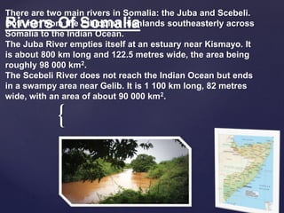
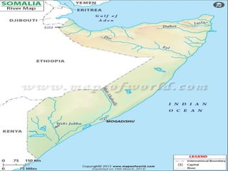
2. {
There are two main rivers in Somalia: the Juba and Scebeli.
Both run from the Ethiopian Highlands southeasterly across
Somalia to the Indian Ocean.
The Juba River empties itself at an estuary near Kismayo. It
is about 800 km long and 122.5 metres wide, the area being
roughly 98 000 km2.
The Scebeli River does not reach the Indian Ocean but ends
in a swampy area near Gelib. It is 1 100 km long, 82 metres
wide, with an area of about 90 000 km2.
Rivers Of Somalia
3. -The Scebeli River floods in rainy season and fills up natural
ground depressions and an ancient bed, creating temporary
sloughs, swamps, pools, creeks and small lakes. Flooding of the
Juba River also fills natural depressions, especially oxbows in its
lower part. Marshes near Gelib are flooded by collected water and
Juba infiltration
4.
5. The Shebelle River (Somali: Webi Shabeelle, Arabic’ نهر
شبيلي ,Amharic እደላ, Italian:
Webi Scebeli)
River Of Shabele begins in the highlands of Ethiopia, and then flows
southeast into Somalia towards Mogadishu.
Near Mogadishu, it turns sharply southwest, where it follows the
coast. Below Mogadishu, the river becomes seasonal. During most
years, the river dries up near the mouth of the Jubba River, while in
seasons of heavy rainfall, the river actually reaches the Jubba and
thus the Somali Sea
The Shebelle river's name is derived from the Somali term Wabi
Shabeelle, meaning "Leopard/Tiger River". The Somali administrative
regions consisting of Shabeellaha Dhexe and Shabeellaha
Hoose are also named after the river.
Shabele River
6. The Shebelle has a number of tributaries, both
seasonal and permanent rivers. They include:
Erer River
Galetti River
Wabe River
The Fafen only reaches the Shebelle in times
of heavy rainfall; its stream usually ends before
reaching the main river.
Tributaries
7. The Juba River has three main tributaries in its upper catchment in
Ethiopia, namely: the Dawa, the Genale and the Weyb, all of which
flow south-eastwards. The Weyb and the Genale unite to form the Juba
River just north of Doolow in Ethiopia; while the Dawa tributary joins
the Juba River at Doolow Town, just after the Somalia-Ethiopia border
(Figure 1). The total length of Juba River is 1,808 Km, with a catchment
area of about 210,010 Km2. On average, 186 cubic meters (186,000
litres) of water flow every second down the Juba River at Luuq station.
Juba River
8. The alluvial plains of the Juba and Shabelle have been described as
the breadbasket of Somalia. For several decades irrigated agriculture
has been practiced along the plains, producing food not only for local
consumption but also for export. Available records indicate that before
the collapse of the former Somali government in 1990, over 220,000
hectares of land along the flood plains were under either controlled
irrigation or recession farming. Maize, sesame, fruits and vegetables
were some of the crops grown for local market, while sugarcane and
rice were grown for both local and foreign markets.
The Economic Importance of Juba
and Shabelle
9. Water resources management of the Juba and Shabelle Rivers involves
the dual imperatives of managing floods and providing a steady supply
of irrigation water. According to the traditional Somali custom, the right
to use water depends on access to land along the rivers, and no approval
was needed for one to extract water. During the former Somali
government, water legislation institutionalized water management
through laws that regulated the functioning of the institutions involved.
An example is the Natural Water Resources Law of 1984, which
governed the regulated access to and use of the Juba river waters. Water
exploitation at the national and regional level was regulated through
legal and institutional structures set up by the central government
Water Resources Management and
Monitoring Systems