SlideShare a Scribd company logo
1 of 76
Download to read offline
Chapter 4: Drainage systems and water resource of Ethiopia and
the Horn
• About 71% of the earth’s total surface is covered by water bodies.
• 97.5% is alkaline accumulated in seas and oceans, 2.5% is fresh water.
• Of the total freshwater, 68.7% is deposited in glaciers, 30.1% in ground
water, 0.8% in permafrost and 0.4% in surface waters.
• Water in lakes, rivers, atmosphere, soils and wetlands are considered as
surface waters.
• Around 0.7 % of the total land mass of Ethiopia is covered by water
bodies.
• The surface water potential of Ethiopia is estimated to be 124.4 billion
cubic meters.
• Hence, Ethiopia is called the water tower of “Eastern Africa”
02/05/2020 Ethiopian Geography and the Horn GeES, MU 1
4.2. Major Drainage System of Ethiopia
• The flow of water through well-defined channel is known as
drainage.
• A drainage system is made up of a principal river and its tributaries.
• The major river basins are determined by topographical structures:
a) The topography of the outward sloping of the Western and
South eastern plateaus
b) The structural formation of the Rift Valley with its in-ward-
sloping escarpments resulting mainly in an inland drainage
system.
c) Faults and joints that structurally influence part of the courses
of many rivers.
02/05/2020 Ethiopian Geography and the Horn GeES, MU 2
• Ethiopia possesses three broadly classified drainage systems namely
Western, Southeastern and Rift Valley drainage systems.
• Western and the Southeastern drainage systems are separated by the Rift
Valley system.
4.2.1. The Western Drainage Systems
• It accounts for about 60% of the total water flow of the country.
• It drains 40% of total area of the country.
• It is made up of 4 major river basins which flow westward except the
Ghibe (Omo) basin which flows southward. The remaining are Abay,
Baro and Tekeze basins.
• This system is called the Mediterranean drainage system because the
three basins joining the Nile river in Sudan finally drain to the
Mediterranean Sea.
02/05/2020 Ethiopian Geography and the Horn GeES, MU 3
• The drainage systems are
divided into 3 groups:
1. The Western
(Mediterranean)
drainage system
2. The Southeastern
(Indian Ocean)
drainage system
3. The Inland (Rift
Valley) drainage system
Flows to
the Nile
Flows to the Somalia
Drainage Basins of Ethiopia
02/05/2020 Ethiopian Geography and the Horn GeES, MU 4
• The largest river both in volumetric discharge is the Abay.
• Abay river basin covers 199,812 km2
, covering parts of Amhara, Oromia
and Benishangul-Gumuz regional states.
• The river carries 65 % of the annual water flow of the region.
• Abay which rises from Lake Tana (its origin from Sekela, Choke
mountain) flows 1,450 km and joins the White Nile in Khartoum, Sudan
to form the Nile River.
• More than 60 streams drains to Abay within elevation ranging between
500 - 4261 m.a.s.l.
• The largest tributary in Abay River is Ghilgel Abay (Little Abay).
• Tekeze carryies 12 % of the annual water flow of the region.
02/05/2020 Ethiopian Geography and the Horn GeES, MU 5
• Tekeze drains 82,350 Km2
of land surface within elevation ranging
between 536-4517 m.a.s.l.
• It has two main tributaries (Angereb and Goang) which rises in the
central highlands of Ethiopia.
• It is termed Atbara in Sudan, which is a tributary of the Nile.
• The total mean annual flow is 8.2 billion metric cubes (bmc).
• The Baro-Akobo and Ghibe / Omo rivers drain the wettest highlands in
the south and southwestern Ethiopia.
• Baro-Akobo carries 17 % and Ghibe / Omo river carries 6% of the
annual water flow.
• Ghibe/ Omo river basin drains an area of 79,000 km2
.
• Baro Akobo river basin has an area of 75,912 km2
.
02/05/2020 Ethiopian Geography and the Horn GeES, MU 6
• Baro Akobo river basin covers parts of BenishangulGumuz, Gambella,
Oromia and SNNPR.
• The total mean annual flow from the river basin is 23.6 BMC.
• The Baro and Akobo river forms the Sobat River in South Sudan.
• The Ghibe /Omo River finally empties into the Chew-Bahir at the mouth of
Lake Turkana (an elongated Rift Valley lake) forming an inland drainage.
4.2.2. The Southeastern Drainage Systems
• It is drained by the southeastern drainage systems.
• The basin slopes south-eastwards across large water deficient plains.
• The highlands include plateaus of Arsi, Bale, Sidama and Harerghe.
• Wabshebelle and Ghenale rivers cross the border into Somalia, carrying 25
% of the annual water flow of Ethiopia.
02/05/2020 Ethiopian Geography and the Horn GeES, MU 7
Ghenale River basin

It has an area of 171,042 km2.

It covers parts of Oromia, SNNPR, and Somali regions.

It has fewer tributaries but carries more water than Wabishebelle, reaches the Indian Ocean.

The basin flows estimated to be 5.8 BMC within elevation ranging between 171-4385
m.a.s.l.

When Ghenale River reaches in Somalia, it is named the Juba River.
Wabishebelle River basin

It has a total catchment area of 202,697 km2, and largest river in terms catchment area.

It drains parts of Oromia, Harari and the Somali regions.

It is the longest river in Ethiopia.

Its tributaries are left bank and, most of them, are intermittent.

Wabishebelle fails to reach the Indian Ocean where at the end of its journey it flows parallel
to the coast before its water disappears in the sands, just near the Juba River.
02/05/2020 Ethiopian Geography and the Horn GeES, MU 8
4.2.3. The Rift Valley Drainage System
• It is an area of small amount of rainfall, high evaporation and small
catchment area.
• The only major river basin is that of the Awash.
• Awash river basin has a catchment area of 114,123 km2.
• It has an average annual discharge of 4.9 BMC.
• It originates from Shewan plateau in central highlands of Ethiopia.
• It covers parts of the Amhara, Oromia, Afar, Somali, Dire Dawa ...
• It is the most utilized river in the country.
• Following the Rift Valley orientation, the Awash flows in a northeast
direction.
02/05/2020 Ethiopian Geography and the Horn GeES, MU 9
• Awash river has its source from Mecha highlands west Shewa and
flows into lake Abe on the Ethio-Djibouti border.
• The Afar drainage sub-basin has no stream flow.
• It is an area of little rain, very high temperature and very high
evaporation.
• Lake Afrera and Asale are the only main surface waters in the Awash
basin which are not the result of any meaningful surface flow.
• The formation Lake Afrera and Asale is related to tectonic activities.
• Southern part of the Rift Valley sub-basin is characterized by a
number of lakes and small streams.
• It is described as lakes region, occupying fault depression.
02/05/2020 Ethiopian Geography and the Horn GeES, MU 10
• Important streams drain to the Lakes' basin
Meki and Kater flow into Lake Ziway
Teggi and Guracha flow into Lake Langano
Gidu and Lendi flow into Lake Shalla
Bilate, Chidabo and Gelana flow into Lake Abbaya
Bullbulla river connects Lake Ziway and Lake Abiyata
Horocalo river connects Lake Abiyata and Lake Langano
Segen drains into Chew bahir
4.3. Water Resources: rivers, lakes and sub-surface water
4.3.1. The Ethiopian Rivers
• Ethiopia is endowed with many rivers.
• Majority of the rivers originate from highland areas.
02/05/2020 Ethiopian Geography and the Horn GeES, MU 11
Table: Data on major Ethiopian rivers
River
Catchment
Area(km2
)
Annual
Volume BMC Terminus/Mouth Major tributaries
Abay 199,812 4.5 Mediterranean
Dabus, Dedessa, Fincha, Guder,
Muger, Jema, Beshilo
Wabishebelle 202,697 3.4
Coast of Indian
Ocean
Ramis Erer, Daketa Fafan
Genale
Dawa 171,042 6 Indian-Ocean
Dawa, Weyb, Welmel,
Mena
Awash 114,123 4.9 Inland (within Eth) Akaki, Kesem, Borkena, Mile
Tekeze 87,733 8.2 Mediterranean Goang, Angereb
Gibe (Omo) 79,000 16.6 Lake Turkana Gojeb
Baro Akobo 75,912 23.23 Mediterranean Akobo
• Ethiopian rivers form 12 major watersheds separating the Mediterranean
Sea from the Indian Ocean drainage systems.
02/05/2020 Ethiopian Geography and the Horn GeES, MU 12
General characteristics of Ethiopian rivers
• Major rivers originate from the highlands.
• Majority of Ethiopian rivers are trans-boundary.
• The rivers are have extreme seasonal fluctuation due to RF seasonality.
• In the wet season, runoff is higher and rivers are full bursting their
banks, destroying small bridges, damage roads and flooding low lands.
• They became mere trickles of water or even dry up in the dry seasons.
• Due to ruggedness, they have rapids and waterfalls along their course.
• They have cuts, steep-sided river valleys and deep gorges.
• Rivers flow on steep slopes having steep profiles.
• Some rivers serve as boundaries, international and domestic
administrative units.
02/05/2020 Ethiopian Geography and the Horn GeES, MU 13
4.3.2. The Ethiopian Lakes
• Relatively Ethiopia is rich in lakes.
• The lakes are the result of tectonic process that took place during Quaternary period
of Cenozoic era.
• Except few lakes (Tana, Hayik, & Hashege), majority of lakes are located within the
Rift Valley System.
• Lake Tana, the largest lake, occupies a shallow depression in the highlands.
• The Tana depression is believed to be formed following slower sinking and reservoir
by lava flow between Gojjam and Gonder massifs.
• Ethiopia is gifted with crater lakes; at Bishoftu, Wonchi, Hayk and the Crater Lake
on top of Mount Zikwala.
• Lake Hashenge is formed on a tectonic basin.
• Other types are man-made such as Lakes Koka, Fincha and Melka Wakena,
and other lakes dammed following hydroelectric power generation projects.
02/05/2020 Ethiopian Geography and the Horn GeES, MU 14
• Cluster of lakes are lined
up within Main Ethiopian
Rift.
• Lake Abaya is the largest
of all the lakes in the
system.
• The southern tip of the Rift
Valley forms the marshy
land called the Chew Bahir
which is drained by Segan
and Woito rivers.
• Lake Shala and Ziway are
the shallowest and the
deepest lakes in the central
Ethiopian Rift Valley.
02/05/2020 Ethiopian Geography and the Horn GeES, MU 15
Major Lakes in Ethiopia
Lakes
Area
(km2
)
Max.
Depth(m)
Lakes
Area
(km2
)
Max.
Depth(m)
Tana 3600 9 Abijata 205 14
Abaya 1162 13.1 Awassa 129 10
Chamo 551 13 Ashenge 20 25
Ziway 442 8.95 Hayk 5 23
Shala 409 266* Beseka 48.5 11
Koka 205 9
02/05/2020 Ethiopian Geography and the Horn GeES, MU 16
4.3.3. Subsurface (ground) water resource of Ethiopia
• Climatic and geophysical conditions determine the availability of
groundwater resource.
• The ground water potential is estimated to be 2.6 - 6.5 BMC.
• Other studies believed that Ethiopian groundwater potential is believed
to range between 12-30 BMC.
4.4. Water Resources Potentials and Development in Ethiopia
1. Hydro-electric Potential
• The exploitable potential of hydroelectric power is 45000 megawatts.
• The first hydroelectric power generation plant was installed on Akaki
River (Aba Samuel) in 1932.
02/05/2020 Ethiopian Geography and the Horn GeES, MU 17
• Grand Ethiopian Renaissance Dam is the largest dam under construction aiming
to generate 6400 megawatts (?).
• Gilgel Gibe III hydropower project has gone operational generating 1870
megawatts.
• Ethiopia is administering 14 hydroelectric power plants constructed on Lake
Aba Samuel, Koka, Tis-Abay, Awash, MelkaWakena, Sor, Fincha, Gibe/Omo,
Tana Beles and Tekeze, generating close to 4000 megawatts of energy.
• The country is exporting electricity to the neighboring countries.
• The major problem related to the use of Ethiopian rivers for the generation of
hydroelectric power are:
The seasonal flow fluctuations.
Impact of climate change and variabilities.
The severe erosion from the highlands and sedimentation in the reservoirs.
02/05/2020 Ethiopian Geography and the Horn GeES, MU 18
2) For Irrigation and Transportation
• In the lowland areas of Ethiopia, the demand for irrigation is high.
• Ethiopia’s potential of irrigation is estimated to be 5.3 million hectares.
• The Baro-Akobo and Genale Dawa river systems have large irrigation
potential compared to other basins.
• More than 60% of the area under irrigation so far is located in Rift Valley
drainage system.
• Majority of hydro-electric reservoirs are multi-purpose and are expected to
contribute for irrigation.
• Majority of Ethiopian rivers are not suitable for transportation.
• The Baro at its lower course is the only navigable river.
• Ethiopian lakes are much suitable for transportation than rivers.
• Lake Tana and Abaya are the most used for transportation.
02/05/2020 Ethiopian Geography and the Horn GeES, MU 19
3) Fishing and Recreation
• Majority of Ethiopian lakes are rich in fish.
• The annual production of fish is estimated to be 31.5 thousand tons.
• The exploitable potential is larger than the current annual production.
• Lake Tana leads the potential by estimated 8,000-10,000 tons per year.
• Fish production from Lake Chamo is estimated at 4,500 tons per year.
• More than 60% of fish supplies are coming from Main Rift Valley lakes.
02/05/2020 Ethiopian Geography and the Horn GeES, MU 20
Some of the problems for fishing in the lakes are:
the lakes threatened by sedimentation.
invasive species (water hyacinth).
over exploitation and expansion of investments around lakes
•What makes Ethiopian rivers and lakes important for recreational
and tourist attractions?
othe existence of variety of fish, birds and other aquatic life forms in
the lakes.
oThe scenic beauty of the lakes, the hot springs around them.
oThe spectacular river gorges and the most impressive waterfalls (eg.
Tis-Abay waterfall).
02/05/2020 Ethiopian Geography and the Horn GeES, MU 21
Chapter 5: the climate of Ethiopia and the Horn
5.1. Introduction
Ethiopia is characterized by wide variety of altitudinal ranges and
diverse climatic conditions.
 Ethiopia is subjected to large temporal and spatial variations in
elements of weather and climate because of its closeness to the
equator and the Indian Ocean.
 Ethiopian climate is mainly controlled by:
 The seasonal migration of the Intertropical Convergence Zone
(ITCZ).
 Associated atmospheric circulations.
 The complex topography of the country.
02/05/2020 Ethiopian Geography and the Horn GeES, MU 22
Weather and climate
Weather
• It is the instantaneous/current state of the atmosphere composing
temperature, atmospheric pressure, humidity, wind speed and direction,
cloudiness and precipitation.
Climate
• It is the state of the atmosphere over long time periods.
• It considers extremes or variations that may occur beyond the average
conditions.
Climate is determined by latitude, elevation, nearby water, ocean
currents, topography, vegetation, and prevailing winds
• The global climate system and any changes that occur within it also
influence local climate.
02/05/2020 Ethiopian Geography and the Horn GeES, MU 23
Cont’d
Expressions of weather
• Hotness or coldness
• Rainy or cloudiness of air you are feeling on the daily
• Sunniness
• Windiness or calmness
5.2. Elements and controls of weather and climate
• The determining factors are called controls of weather and climate.
Elements Controls
1. Temperature 1 Latitude/angle of the Sun
2. Precipitation and humidity 2 Land and water distribution
3. Winds and air pressure 3 Winds and air pressure
4 Altitude and mountain barriers
5 Ocean currents
02/05/2020 Ethiopian Geography and the Horn GeES, MU 24
5.2.1. Controls of weather and climate
A. Latitude
• It is the distance of a location from the equator.
• The sun shines on equator for more hours in the year than anywhere else.
• Moving away from the equator towards the poles, less solar insolation is
received during the year and the temperature become colder.
• Ethiopia’s latitudinal location has bearings on its temperature.
Latitudinal location of Ethiopia and the Horn resulted:
• High average temperatures
• High daily and small annual ranges of temperature
• No significant variation in length of day and night between summer and
winter.
02/05/2020 Ethiopian Geography and the Horn GeES, MU 25
B. Inclination of the Earth's Axis
• The earth’s rotation axis makes an angle of 66 ½ ° with the plane of its orbit
around the sun, or about 23 ½ ° from the perpendicular to the ecliptic plane.
• The inclination determines the location of the Tropics of Cancer, Capricorn and
the Arctic and Antarctic Circles.
• As the earth revolves around the sun, this inclination produces a change in the
directness of the sun's rays, which in turn causes the directness of the sun and
differences in length of day and seasons.
Equinoxes and Solstices
• An equinox is the instant of time when the sun strikes the plane of the equator.
• During this passage the length of day and night are equal.
• Revolution of the earth along its orbit, the inclination of its axis from the
plane of that orbit, and the constant position (parallelism) of the axis causes
seasonal changes in the daylight and darkness periods.
02/05/2020 Ethiopian Geography and the Horn GeES, MU 26
cont’d
•Equinox appears twice a year. Two major equinoxes:
I. The Vernal (spring) equinox

It is the day when the point of verticality of sun’s rays crosses the equator northwards.

This equinox experiences in Northern Hemisphere when the sun is exactly above the
equator.

During this period, the length of day and night are equal.

Vernal (spring) equinox marks the beginning of spring season.
March 21 marks the offset of the vernal equinox.
II. The Autumn equinox:
•It appears to happen when the sun crosses equator giving approximately equal length
between day and night.
• It appears to happen when the visible sun moves south across the celestial equator on
23rd of September.
•It marks the beginning of Autumn season.
02/05/2020 Ethiopian Geography and the Horn GeES, MU 27
Solstice
• It is an event when the overhead sun appears to cross northern/southern points.
• It results in unequal length of days and nights in the hemispheres.
• Both hemispheres during this event has either the most or least sunlight of the year.
I. The summer Solstice
On June 21st, the northern hemisphere has maximum tilt towards the sun experiencing longest
daylight of the year.
It is the astronomical first day of summer in the Northern Hemisphere.
The sun is at its highest position in the noonday sky, directly above 23 ½ in the Tropic of Cancer.
II. The winter solstice
22nd of December is the day when the maximum southward inclination is attained in the
Southern Hemisphere.
The sun travels shortest length causing longest night and shortest daylight.
In the Northern Hemisphere, it occurs when the sun is over the Tropic of Capricorn, which is
located at 23 ½ ° south of the equator.
02/05/2020 Ethiopian Geography and the Horn GeES, MU 28
The apparent path of the sun at different latitudes
02/05/2020 Ethiopian Geography and the Horn GeES, MU 29
C. Altitude
• It is the height of location above the sea level.
• There is a general decrease in temperature with increasing elevation.
• The average rate at which temperature changes per unit of
altitudinal change is known as lapse rate.
• The lapse rate is limited to the troposphere/lower layer of the
atmosphere.
• The normal lapse rate is 6.5°C per km rise in altitude.
Types of lapse rate:
i. Dry adiabatic laps rate
ii. Wet Adiabatic laps rate
iii. Environmental lapse rate or Atmospheric lapse late
02/05/2020 Ethiopian Geography and the Horn GeES, MU 30
5.3. Spatiotemporal patterns and distribution of temperature and rainfall in Ethiopia
5.3.1. Spatiotemporal Distribution of Temperature
Temperature of Ethiopia and the Horn is determined by altitude (has greater
influence), humidity, and winds.
The spatial distribution of temperature in Ethiopia is primarily determined by
altitude and latitude.
Every part of Ethiopia experiences overhead sun twice a year because of the
location at close to equator, a zone of maximum insolation.
However, tropical temperature conditions have no full spatial coverage in
Ethiopia.
 They are limited to the lowlands in the peripheries.
Temperature decreases towards the interior highlands.
02/05/2020 Ethiopian Geography and the Horn GeES, MU 31
Mean annual temperature varies from over 30 0c in the tropical lowlands
to less than 100c at very high altitudes (Bale Mountains Vs Afar
Depression).
 Environmental influences have traditional expressions in Ethiopia and
there are local terms denoting temperature zones.
Table : Temperature versus altitude
Altitude (meter)
Mean ann temp (0C)
Description Local Equivalent
3,300 and above 10 or less Cool Wurch
2,300 - 3,300 10 – 15 Cool Temperate Dega
1,500 - 2,300 15 – 20 Temperate Woina Dega
500 - 1,500 20 – 25 Warm Temperate Kola
below 500 25 and above Hot Bereha
02/05/2020 Ethiopian Geography and the Horn GeES, MU 32
• The temporal distribution of temperature is characterized by extremes due to
latitude and cloud cover.
• However, some parts of the country enjoy a temperate climate.
• In Ethiopia, as in all places in the tropics, the air is frost free and changes in
solar angles are small making intense solar radiation.
• Ethiopia’s daily temperatures are more extreme than its annual averages.
• Daily maximum temperature varies from 37 oC over the lowlands and
southeast to 10 -15 oC over the northwestern and southwestern highlands.
• But in the monthly averages, variation is minimal and the annual range of
temperature is small.
• In Ethiopia, temperature shows seasonal variations.
Example: months from March to June have records of highest temperatures.
02/05/2020 Ethiopian Geography and the Horn GeES, MU 33
• Low temperatures are recorded from November to February.
• There is a slight temperature increase in summer.
• Southern part receives highest records of temperature in autumn and
spring following the relative shift of the sun.
• In the northern, summer season is characterized by higher temperature.
• Certain seasons should have special considerations. For instance, the
southern and southwestern highlands experience reduced temperature.
• This is because the temperature and the amount of energy reaching the
surface is related with the directness of the sun.
• The direction of rain bearing winds (leeward or windward side)
determines the temperature variations in mountainous regions.
02/05/2020 Ethiopian Geography and the Horn GeES, MU 34
5.3.2. Spatiotemporal Distribution of Rainfall
• Rainfall system of Ethiopia is complexities.
• The rainfall system is characterized by spatial and temporal variabilities.
• Rainfall is influenced by the position of Intertropical Convergence Zone
(ITCZ).
• The convergence of Northeast Trade winds and the Equatorial Westerlies
forms the ITCZ, which is a low-pressure zone.
• The inter-annual oscillation of the surface position of the ITCZ causes a
variation in the wind flow patterns.
• As the shift takes place, equatorial westerlies from the south and
southwest invade most parts of Ethiopia bringing moist winds.
02/05/2020 Ethiopian Geography and the Horn GeES, MU 35
• Winds decrease the length of rainy seasons and magnitudes.
• The shift takes place when the trade winds from the north retreat giving
the space for equatorial westerlies in July causing variability and
seasonality.
• The ITCZ shifts towards south of equator in January, then Northeast
Trade Winds carrying non-moisture-laden.
• In January, Afar and parts of Eritrean coastal areas experience rainfall.
• In March and September, the ITCZ shifts towards equator.
• During this time, the central highlands, southeastern highlands and
lowlands receives rainfall as the south easterlies bring moist winds.
02/05/2020 Ethiopian Geography and the Horn GeES, MU 36
Seasonal or Temporal Variabilities
• The rainfall is highly variable in amount and distribution across seasons.
• The seasonal and annual rainfall variations are results of the macro-scale
pressure systems and monsoon flows which are related to the changes in the
pressure systems.
• The temporal variabilities of rainfall are characterized by;
i. Summer (June, July, August)
• From mid-June to mid-September, majority of Ethiopian regions, receive rainfall during
the summer season as the sun overheads north of the equator.
• High pressure cells develop on the Atlantic and Indian Oceans around the tropic of
Capricorn, but the Indian Ocean is source of rainfall.
• Ethiopia and the Horn come under the influence of the Equatorial Westerlies (Guinea
monsoon) and Easterlies.
• Hence, Guinea monsoon and South easterly winds are responsible for the rain.
02/05/2020 Ethiopian Geography and the Horn GeES, MU 37
ii. Autumn (September, October and November)
 Autumn is the season of the year between summer and winter.
 The exact position of the ITCZ changes over the course of the year, oscillating
across the equator.
The ITCZ shifts towards the equator weakening the equatorial westerlies.
 The south easterlies from Indian Ocean showers the lowlands in southeastern.
iii. Winter (December, January and February)
• The overhead sun is far south of equator in winter.
• Northeasterly winds originating from the landmass of Asia dominantly prevail
Ethiopian landmass.
• It has no significant coverage compared to other seasons.
• The northeasterly winds crossing the Red Sea carry very little moisture and
supplies rain only to the Afar lowlands and the Red Sea coastal areas.
02/05/2020 Ethiopian Geography and the Horn GeES, MU 38
iv. Spring (March, April and May)
• The noonday sun is shining on the equator while shifting north
from south.
• The shift of the ITCZ, results in longer days and more direct
solar radiation providing warmer weather for the northern
world.
• Then, the effect of the northeast trade wind is very much
reduced.
• Conversely, the southeasterlies from the Indian Ocean provide
rain to the highlands of Somalia, and to the central and
southeastern lowlands and highlands of Ethiopia.
02/05/2020 Ethiopian Geography and the Horn GeES, MU 39
Ethiopia has four rainfall regions:
I. Summer rainfall region

In almost all parts of the country, except southeastern and northeastern lowlands.

Two dry and wet summer rainfall regions.
II. All year-round rainfall region
It has many rainy days than any part of the country.
It is a rainfall region in the southwestern part of the country.
Average rainfall= 1,400 to over 2,200 mm/year.
III. Autumn and spring rainfall regions

South eastern lowlands of Ethiopia

Average rainfall = <500 to 1,000 mm.
IV. Winter rainfall region

Receives rain from the northeasterly winds.

Some parts of the Afar region.
02/05/2020 Ethiopian Geography and the Horn GeES, MU 40
5.4 Agro-ecological Zones of Ethiopia
• Ethiopia possesses diverse agro-climatic zones, in terms of temperature.
• Five major climatic zones
A. Bereha - Kolla
 In south, southeast, west and northeastern part of Ethiopia.
B. Woina Dega
 Suitable for majority of crops grown in Ethiopia.
C. Dega
 Long inhabited and has dense human settlement due to reliable rainfall for
agriculture and absence of vector-borne diseases-malaria.
D. Wurch
 Mountain systems of Ras Dashen, Guna, Megezez in North Shoa, Batu, Choke,
Abune Yoseph etc.
02/05/2020 Ethiopian Geography and the Horn GeES, MU 41
Table: Agro Ecological Zones of Ethiopia
Zones
Altitude (m) Mean annual
rainfall (mm)
Length of growing
periods (days)
Mean annual
temperature (0C) Area share
(%)
Wurch (cold to moist) >3,200 900-2,200 211–365 Below 10 0.98
Dega (cool to humid) 2,300 - 3,200 900-1,200 121–210 ≥11.5–17.5 9.94
Weyna Dega (cool sub
humid)
1,500 - 2300 800-1,200 91–120 >17.5 – 20.0 26.75
Kola (Warm semiarid) 500 - 1,500 200-800 46–90 >20.0 – 27.5 52.94
Berha (Hot arid) <500 Below 200 0–45 >27.5 9.39
02/05/2020 Ethiopian Geography and the Horn GeES, MU 42
• Traditional Agro
Ecological Zones
of Ethiopia
02/05/2020 Ethiopian Geography and the Horn GeES, MU 43
5.5. Climate Change/Global Warming: causes, consequences and
response mechanisms
• Climate change is natural and has been there. So why is it our concern now?
• It is a change in the state of the climate.
• It is any change in climate over time due to natural variability or human activities.
5.5.1 Current Trends of Climate in Ethiopia
• Ethiopian climate experiences extremes: drought and flood.
• She ranked 5th out of 184 countries in terms of its risk of drought.
• About 12 extreme drought events were recorded between 1900 and 2010, 7 of the
drought events occurred since 1980.
• The severe drought of 2015/2016 was exacerbated by the strongest El Nino,
causing successive harvest failures and widespread livestock deaths.
02/05/2020 Ethiopian Geography and the Horn GeES, MU 44
Trends in temperature variability
• Over the last decades, Ethiopia has experienced climatic changes.
• Mean annual temperature has shown 0.2°C to 0.28°C rise per decade.
• A rise in average temperature of about 1.3°C has been observed in 1960 -2006.
• Higher rise in temperature was noted in drier areas in July-September.
• The number of ‘hot day’ and ‘hot night’ has shown increment.
• The minimum temperature has increased with 0.37°C to 0.4°C per decade.
Global mean temperature
anomaly: Orange (land) and blue (sea)
02/05/2020 Ethiopian Geography and the Horn GeES, MU 45
Trends in rainfall variability
• Precipitation has remained stable over the last 50 years.
• However, these do not reflect local conditions which are extremely divergent.
• The natural variability in rainfall makes it difficult to detect long-term trends.
• Rainfall variability is increasing (and predictability is decreasing).
• Total average rainfall is declining: southern, south-western and south-eastern
in 1975 and 2010, stong implications for crop production.
• Changes in temperature and rainfall increase the extreme events.
• Major floods have led to loss of life and property in numerous parts of the
country.
• Warming has exacerbated droughts, and desertification in the lowlands is
expanding.
02/05/2020 Ethiopian Geography and the Horn GeES, MU 46
5.5.2. Causes of climate change
A. Natural causes
• Earth orbital changes
• Energy Budget
• Volcanic eruptions
B. Anthropogenic causes
• Human activities
• The warming of earth planet in the past 50 years is majorly driven by
human activities.
• Decomposition of wastes in landfills, agriculture, ruminant digestion and
manure management, synthetic compounds manufacturing, clearing of
land for agriculture and industrial activities have increased concentrations
of greenhouse gases.
02/05/2020 Ethiopian Geography and the Horn GeES, MU 47
5.5.3. Consequences of climate change
 Impacts on human health
• Heat related mortality and morbidity.
• Greater frequency of infectious disease epidemic.
 Impact on water resources
• Melting of snow and glaciers increases rise in sea level, drought and floods,
distorts wind flow pattern and decreases water table.
 Impact on agriculture
• Increases physiological stress and fodder quality and availability.
 Impact on ecosystem
• Success of species, population, and community adaptation are affected
02/05/2020 Ethiopian Geography and the Horn GeES, MU 48
5.5.4. Climate Response Mechanisms
Three major response mechanisms to climate change mitigation, adaptation
and resilience.
A. Mitigation and its strategies
 Mitigation refers to action that is taken to reduce and control greenhouse gas
emissions changing the climate.
 The strategies are reducing the flow of heat trapping greenhouse gases into the
atmosphere, either by reducing sources of these gases or enhancing the “sinks” that
accumulate and store these gases.
Examples:
• Practice energy efficiency.
• Increase the use of renewable energy such as solar.
• Efficient means of transport implementation: electric public transport, bicycle,
shared cars etc
02/05/2020 Ethiopian Geography and the Horn GeES, MU 49
B. Adaptation and its strategies
• Adaptation is defined as adapting to life in a changing climate.
• It involves adjusting to actual or expected future climate.
• It encompasses making the most of any potential beneficial opportunities associated with
climate change.
• The goal is to reduce our vulnerability to the harmful effects of extreme weather events or
food insecurity.
Example:
• Building flood defenses
• Planning for heatwaves and higher temperatures
• Installing water-permeable pavements to better deal with floods and storm water.
• Improving water storage and use are some of measures taken by cities and towns.
• Landscape restoration and reforestation.
• Flexible and diverse crop cultivation.
• Preventive and precautionary measures (evacuation plans, health issues, etc.).
02/05/2020 Ethiopian Geography and the Horn GeES, MU 50
Chapter 6: Soils, Natural Vegetation and Wildlife
Resources of Ethiopia and the Horn
6.1. Introduction
• The past geological process and varied climatic events ensued Ethiopia to
have varied soil and biological diversity.
• The formation and spatial variabilities of soils is related to topographic and
climatic factors, parent material (rocks) and land use.
• The distribution of wildlife and natural vegetation is controlled by many
factors important among which are climate, soil types, drainage, etc.
• Ethiopia possess unique and characteristic fauna and flora with a high level
of endemicity.
• However, manmade as well as natural problems are threatening their
availability and distribution.
02/05/2020 Ethiopian Geography and the Horn GeES, MU 51
6.2. Ethiopian soils: types, degradation and conservation
6.2.1. Definition of soil
• Soil is a composition of mineral particles, organic matter and living
organisms in dynamic equilibrium.
• Its variability reflects the parent material from which the soil was
formed over very long periods of time and the environment.
• It consists of weathered mineral materials (45%), organic matter
(5%), air (20-30%) and water (20-30%).
• The formation of soil depends on the parent material, climate,
topography, living organism and time.
02/05/2020 Ethiopian Geography and the Horn GeES, MU 52
What is weathering ?
• It is the breakdown of rocks at the surface, by the action of rainwater, extremes
of temperature, and biological activity.
• It disintegrates the inorganic substances (rocks) of soils.
Three weathering involving in soil formation:
A. Mechanical (physical) weathering
It causes decrease in size without appreciably altering composition.
Example: Abrasion
B. Biological weathering
It is weakening and subsequent disintegration of rock by plants, animals and microbes.
C. Chemical weathering
It is modification of the chemical and mineralogical composition of the weathered material.
Example: hydrolysis, oxidation, reduction, hydration, carbonation, and solution.
02/05/2020 Ethiopian Geography and the Horn GeES, MU 53
Properties of soil
 Soils have two properties:
A. Physical properties
• They are influenced by composition and proportion of major soil components:
texture, structure and porosity.
B. Chemical properties
 Soil chemistry is the interaction of various chemical constituents that takes place
among soil particles: availability of minerals, electrical conductivity and soil pH.
6.2.2. Major Soil Types in Ethiopia
• Soils are basically derived from crystalline, volcanic and mesozoic
sedimentary rocks.
• Hence, some of the soil divisions are based on the geologic structure.
02/05/2020 Ethiopian Geography and the Horn GeES, MU 54
Cont’d
• There are soils formed due to long waited deposition of sediments.
• FAO has identified 18 soil associations in Ethiopia at scale of 1:2,000,000.
• 11 soil associations cover about 87.4 % of the land area.
Six major soils groups in Ethiopia
1.Nitosols and Acrisols
Nitosols
They are develop on gently sloping ground.
 They are weathered soils but far more productive than other tropical soils.
They are associated with highlands with high rainfall.
 They are originally formed on forest covered areas.
They are characterized by soil leaching: poor in soluble minerals like potassium,
calcium etc.; and rich in non-soluble minerals like iron and aluminum.
02/05/2020 Ethiopian Geography and the Horn GeES, MU 55
• Nitosols are found in Western highlands (Wellega), Southwestern highlands
(Kaffa, Illuababora), Southern highlands, Central highlands, and Eastern
highlands.
Acrisols
• They are inherently infertile soils of the tropics.
• They are degraded chemically and organically very quickly when utilized.
• They have very low resilience to degradation and moderate sensitivity to
yield decline.
• In Ethiopia, it has lost the base nutrients and have low productive capacity.
• They are found along with nitosols in some pockets of southwestern
highlands of Ethiopia where there is high rainfall.
02/05/2020 Ethiopian Geography and the Horn GeES, MU 56
2. Vertisols
 They are heavy clay soils with a high proportion of swelling clays when
wet, and cracks when dry.
 They are extremely difficult to manage (hence easily degraded).
 They have very high natural chemical fertility.
 They develop on volcanic plateau basalt, trachyte and pyroclastic
materials, sedimentary rocks, colluvial slopes and alluvial plains.
 They are soils of highlands and moderate climates.
 They are found in parts of northwestern highlands, central highlands and
southeastern highlands (especially in Gojjam, Shewa, Arsi, Bale and
central Hararghe).
02/05/2020 Ethiopian Geography and the Horn GeES, MU 57
3. Lithosols, Cambisols and Regosol
They are mostly found in rugged topography and steep slopes.
They are young, shallow and coarse textured.
They have low water holding capacity.
They are found in areas of low rainfall.
They have limited agricultural use.
They are found in Central Highlands, Rift Valley Escarpments and highlands in of
western Hararghe.
Regosol and Lithosols are found in the Danakil and eastern Ogaden.
4. Xerosols, Yermosols and Solanchaks
• They are soils of desert/dry steppe soils in arid and semiarid areas.
• They have poor humus content and nitrogen.
• They are rich in phosphorus and potash and can be very fertile if irrigated.
02/05/2020 Ethiopian Geography and the Horn GeES, MU 58
Xerosols
 They have low organic content.
 They are extremely subjected to wind erosion and soluble salts.
 They are found in Ogaden and northeastern escarpments.
Yermosols
 They are drier and more problematic than Xerosols.
Solanchaks
 They are saline soils which develop in areas of high evaporation and
capillary action.
 They are badly managed irrigation schemes may turn soils into solonchaks.
NB:
• Yermosols and Solonchaks cover the Ogaden and Afar plains
02/05/2020 Ethiopian Geography and the Horn GeES, MU 59
5. Fluvisols
They are formed due to deposition of eroded materials from highlands.
They develop on flat or nearly flat ground, on recent alluvial deposits.
They are associated with fluvial (river), marine (sea) and lacustine (lake) deposits, but are
highly variable.
They are found in lower regions of rivers like Omo, Awash, Abay and the plains of Akobo and
Baro Rivers.
They are suitable for intensive agriculture (large-scale irrigation ) as they develop on flat
ground, deposition sites, associated with water.
6. Luvisols
They develop in areas where wet and dry seasons occur in alternation.
They have good chemical nutrients >> agricultural soils in the tropics
They found in Lake Tana area, parts of Northern, Central and Eastern Highlands, parts of
Southern lowlands.
02/05/2020 Ethiopian Geography and the Horn GeES, MU 60
• Soil types
of Ethiopia
02/05/2020 Ethiopian Geography and the Horn GeES, MU 61
6.2.2. Soil degradation
• Soil degradation is a change in soil status resulting in a diminished capacity of the
ecosystem to provide goods and services.
• It is a deterioration of physical, chemical & biological properties of soil.
• It is a critical and growing global problem.
• It is a major concern for at least two reasons:
1) It undermines the productive capacity of an ecosystem.
2) It affects climate through alterations in water and energy balances and disruptions in
cycles of carbon, nitrogen, sulfur, and other elements.
Three major types of soil degradation
i) Physical degradation: the deterioration of the physical properties of soil.
• It includes compaction: densification of soil is caused by the elimination or reduction of
structural pores.
• Soils prone to compaction are susceptible to accelerated runoff and erosion.
02/05/2020 Ethiopian Geography and the Horn GeES, MU 62
• Soil erosion is a three-phase process consisting of the detachment of individual
soil particles, transportation and deposition.
II. Biological degradation
 It results in reduction in soil organic matter content, decline in biomass
carbon, and decrease in activity and diversity of soil fauna.
 It is more severe in the tropics than in the temperate zone – due to high soil
and air temperatures.
iii. Chemical degradation
• It is caused by nutrient depletion, excessive leaching of cat-ions in soils with
low-activity clays - reduce soil pH, buildup of toxic chemicals and elemental.
• Causes of soil degradation include natural and Human-induced.
• Topographic and climatic factors includes steep slopes, frequent floods, storms
and high-velocity wind, high-intensity rains and drought.
02/05/2020 Ethiopian Geography and the Horn GeES, MU 63
6.2.3. Soil erosion control measures
A. Biological control measures
• They include vegetative strips, plantation, and reforestation.
• They can prevent splash erosion and reduces the velocity of surface runoff.
• They increase surface roughness which reduces runoff and increases
infiltration.
B. Physical control measures
• They are used to control the movement of water and wind.
Example:
• terracing, check dams, gabion, trenches, contour ploughing, soil
bunds etc.
02/05/2020 Ethiopian Geography and the Horn GeES, MU 64
6.3. Natural Vegetation of Ethiopia
6.3.1. Introduction
• Natural vegetation refers to a plant cover that develops with little or no
human interference.
• Controlling factors includes climate, soil types and drainage.
• Temperature and precipitation affect the spatial distribution.
• The characteristics of vegetation are determined by elevation and rainfall.
• In lowlands, xeromorphic plants are adapted to drought and high
temperatures.
• Highlands (up to 3000 m) have adequate moisture a variety of forests.
• Ethiopia possesses an estimated number of 6000 species of higher plants
of which 10% are endemic.
02/05/2020 Ethiopian Geography and the Horn GeES, MU 65
6.3.2. Major Natural Vegetation Types of Ethiopia
• We classify the vegetation belts of Ethiopia into 5 groups:
1. Afro-alpine and sub-afro alpine region
• High mountain vegetation is similar to the Alpine vegetation in temperate
regions.
• Ethiopia has the largest extent of Afro-alpine and sub afro-alpine habitats in
Africa.
• They are found on mountains having an elevation ranging between 3,200 and
4,620 m asl.
• The Afro-alpine habitat covers 1.3% of the total landmass of Ethiopia.
• The region is found at very high altitudes (4,000 – 4,620 m).
• The climate of Afro-alpine ecosystems is controlled by latitude and altitude.
02/05/2020 Ethiopian Geography and the Horn GeES, MU 66
• The annul precipitation which ranges between 800 and 1,500 mm, is
mostly in the form of sleet/snow.
• Soils in this ecosystem are mostly shallow and eroded.
• Bale and Semien mountains are typical examples of afro-alpine
vegetations.
• Vegetation in the Afro-alpine region consists of tussock grasslands,
scrub, scattered mosses and lichens while the Sub-afro alpine region is
dominated by woodland, degraded to scrub stages and wet grasslands.
• Lobelia rhynchopetalum (giberra) and Erica arborea (Asta) are some of
the dominant species in the Afro-alpine and sub-afro alpine regions,
respectively.
02/05/2020 Ethiopian Geography and the Horn GeES, MU 67
2. Forest Region
• Forest is a complex ecosystem consisting predominantly of trees that shield earth and
support numerous life forms.
• They are characterized by variation in mean annual rainfall: 200 and 2,200 mm.
• These wide variations in rainfall and altitude result in two broad classification of forests:
highlands and Lowland forests.
• Highland forests include Hagenia Abyssinia (Kosso), Juniper procera (tid), Arundinaria
Alpina(kerkha), Podocarpus falcatus (zigba), Aningeria adolfi-friedericii (keraro) and Olea
africana (Weyra).
• Lowland forests includes baphia.
• Gallery (riverine) forests stretch along the banks of the lower courses of rivers.
• Riverine forests are classified as lowland forests found in the banks of Awash,
Wabishebelle, Ghenale etc.
• Dominant species include Ficus sur (sholla) and different kinds of acacia trees.
02/05/2020 Ethiopian Geography and the Horn GeES, MU 68
Cont’d
3. Woodland Savannah Region
• They are found in areas of wide altitudinal ranges (250 to 2,300 m).
• The large part of this region is found at a lower elevation and in a drier
environment.
• The plants in the woodland savannah are known for their xeromorphic
characteristics like shading of leaves during the dry season.
• The characteristics of vegetation types between savannahs and woodlands.
• Woodland savannah can be classified into three divisions:
a) Juniper procera (tid) is dominant species. The difference is in height: 3 - 45 meters tall
in the forests and 10 -15 meters in the woodlands.
b) Acacia woodlands are dominated by trees and shrubs, which belong to the 'Acacia‘:
Acacia etbaica (grar),Acacia mellifera (Konter).
c) Mixed deciduous woodlands are most of the trees in mixed deciduous woodlands shed
their leaves during the dry season.
02/05/2020 Ethiopian Geography and the Horn GeES, MU 69
4. Steppe and Semi Desert Regions
• They are common in the arid and semiarid parts of the country.
• The steppe gets a mean annual rainfall of 100 to 550 mm as compared to 50
to 300 mm for the semi desert areas.
• Even though there is a variation in the degree of alkalinity and salinity, soils
in both regions are alkaline and saline.
• Xerophytic plants (i.e. drought-resisting plants) are the dominant vegetations.
• Short shrubs, scattered tufts of grass species and a variety of acacias are some
of the examples.
• Where there are moist soils, rich vegetation of acacia and palm trees may be
observed.
• Trees are restricted to fringes along watercourses.
02/05/2020 Ethiopian Geography and the Horn GeES, MU 70
6.3.3. Natural vegetation Degradation
• Ethiopia's forest resources have been disappearing due to:
1. Clearing of forests for cultivation.
2. Timber exploitation practices.
3. Charcoal burning and cutting for fuel.
4. Extensions of coffee and tea production areas.
5. Overgrazing
6. Expansion of settlements, and clearing for construction.
6.3.4. Natural Vegetation Conservation
• There are three main approaches of biodiversity conservation:
a) Protection: sanctuaries, national parks, and community conservation areas.
b) Sustainable forest management: sustainable harvesting of forest products to provide
a source of financial income.
c) Restoration or rehabilitation: recovery of a deraded forest to improve ecosystem
services.
02/05/2020 Ethiopian Geography and the Horn GeES, MU 71
6.4. Wild Life/wild animals in Ethiopia
• Ethiopia possess unique and characteristic fauna with a high level of
endemicity.
• She has about 860 avian species, 279 species of mammals, 201 species of
reptiles, 23 species of amphibians, and 150 freshwater fish.
• A total of 279 mammalian species of which 31 are endemic are known to
occur in Ethiopia.
• Endemic species require urgent conservation action:
Example: Walia Ibex (Capra walie), Gelada Baboon (Theropithecus gelada),
Mountain Nyala (Tragelaphus buxtoni), Ethiopian Wolf (Canis simensis),
Starck s Hare (Lepus starcki).
‟
• The main wild life concentrations occur in the southern and western parts.
02/05/2020 Ethiopian Geography and the Horn GeES, MU 72
4.4.1 Major groupswild Life/wild animals
• Wild animals in Ethiopia can be classified into five major groups:
1) Common wild animals (found in many parts of the country (e.g. hyenas, jackals).
2) Game (lowland) animal, (herbivores like giraffes, wild asses, zebras etc. and
carnivores like lions, leopards, and cheetahs).
3) Tree animals or arboreals (monkeys, baboons).
4) A variety of birds in the Rift Valley lakes.
5) Rare animals (gelada baboon and Semien fox) scattered in highlands; walia- ibex in
the Semien Massifs, Nyala in the Arsi Bale massifs).
6.4.2. Wildlife Conservation
• The importance of wildlife can be categorized as ecological importance, economic
importance, investigatory importance, conservation of biological diversities etc.
02/05/2020 Ethiopian Geography and the Horn GeES, MU 73
• Wild animals can be used for:
scientific and educational researches (for medical and environmental studies).
physical and mental recreation (aesthetic value).
promotion of tourism (economic value).
potential for domestication and maintaining ecological balance.
• To prevent the destruction of wildlife, a total area of nearly 100,000 Km2 of
national parks, sanctuaries, community conservation areas, botanical gardens,
wildlife reserves are established in different part of the country.
• In Ethiopia, there are:
21 major national parks,
2 major wildlife sanctuaries,
3 wildlife reserves,
6 community conservation areas,
2 wildlife rescue centres,
22 controlled hunting areas,
2 botanical gardens, and 3 biosphere reserves
02/05/2020 Ethiopian Geography and the Horn GeES, MU 74
• Spatial distribution
of National Parks
(four national
parks are not
mentioned)
02/05/2020 Ethiopian Geography and the Horn GeES, MU 75
• Some national parks are unique in their wild animals they have:
a) Abiyatta-Shalla lakes National Park: is a place of bird sanctuary such as flamingos and
pelicans.
b) Omo, Mago, and Gambela National Parks have hippopotamus and crocodiles in rivers
and lakes.
c) Semien and Bale Mountains National Parks have rare animals like Walia ibex, Semien
fox, gelada baboon and Nyala.
6.4.3. Challenges of wildlife conservation in Ethiopia
• Limited awareness on the importance of wild life.
• Expansion of human settlement in protected areas.
• Conflict over resource and overgrazing.
• Illegal wildlife trade and excessive hunting.
• Tourism and recreational pressure.
• Mining and construction material extraction and forest fire.
02/05/2020 Ethiopian Geography and the Horn GeES, MU 76

More Related Content

What's hot

FreshMan Geography Lecture 2.pptx
FreshMan Geography Lecture 2.pptxFreshMan Geography Lecture 2.pptx
FreshMan Geography Lecture 2.pptxAlazarWake1
 
file_1622440466657.pdf
file_1622440466657.pdffile_1622440466657.pdf
file_1622440466657.pdfhabtamu292245
 
History of Ethiopia & the Horn Unit 1 (1).pptx
History of Ethiopia & the Horn Unit 1 (1).pptxHistory of Ethiopia & the Horn Unit 1 (1).pptx
History of Ethiopia & the Horn Unit 1 (1).pptxTeamireabDesta
 
Geography 1 st year.pdf
Geography 1 st year.pdfGeography 1 st year.pdf
Geography 1 st year.pdfTemesgenAzezew
 
4_5825656793769971825.pptx
4_5825656793769971825.pptx4_5825656793769971825.pptx
4_5825656793769971825.pptxWakjiraTesfaye
 
Physical Middle East
Physical Middle EastPhysical Middle East
Physical Middle EastAlison Kurtz
 
History of Ethiopia and the Horn Common Course (2).pptx
History of Ethiopia and the Horn Common Course (2).pptxHistory of Ethiopia and the Horn Common Course (2).pptx
History of Ethiopia and the Horn Common Course (2).pptxGalassaAbdi
 
Critical Short Notes.pptx
Critical Short Notes.pptxCritical Short Notes.pptx
Critical Short Notes.pptxSebehadinKedir
 
Ess 5.1 Soil formation
Ess 5.1 Soil formationEss 5.1 Soil formation
Ess 5.1 Soil formationpata19
 
Physical geography
Physical geographyPhysical geography
Physical geographymgdean
 
Grade 11 Geography Atmosphere notes.pptx
Grade 11 Geography Atmosphere notes.pptxGrade 11 Geography Atmosphere notes.pptx
Grade 11 Geography Atmosphere notes.pptxBrilliant Maredi
 
Unit 2 Physical Geography
Unit 2 Physical GeographyUnit 2 Physical Geography
Unit 2 Physical GeographyCarlos Arrese
 

What's hot (20)

Chapter 2- Geology of Ethiopia and the Horn (GeES 1011).pptx
Chapter 2- Geology of Ethiopia and the Horn  (GeES 1011).pptxChapter 2- Geology of Ethiopia and the Horn  (GeES 1011).pptx
Chapter 2- Geology of Ethiopia and the Horn (GeES 1011).pptx
 
FreshMan Geography Lecture 2.pptx
FreshMan Geography Lecture 2.pptxFreshMan Geography Lecture 2.pptx
FreshMan Geography Lecture 2.pptx
 
file_1622440466657.pdf
file_1622440466657.pdffile_1622440466657.pdf
file_1622440466657.pdf
 
Chapter Two.pptx
Chapter Two.pptxChapter Two.pptx
Chapter Two.pptx
 
Chapter Three.pptx
Chapter Three.pptxChapter Three.pptx
Chapter Three.pptx
 
ppt cha 1.pptx
ppt cha 1.pptxppt cha 1.pptx
ppt cha 1.pptx
 
Chapter1- Geography of Ethiopia and the Horn (GeES 1011) freshman course
Chapter1- Geography of Ethiopia and the Horn (GeES 1011) freshman course Chapter1- Geography of Ethiopia and the Horn (GeES 1011) freshman course
Chapter1- Geography of Ethiopia and the Horn (GeES 1011) freshman course
 
Chapter 3.pptx
Chapter 3.pptxChapter 3.pptx
Chapter 3.pptx
 
Logic 1-6.pptx
Logic 1-6.pptxLogic 1-6.pptx
Logic 1-6.pptx
 
History of Ethiopia & the Horn Unit 1 (1).pptx
History of Ethiopia & the Horn Unit 1 (1).pptxHistory of Ethiopia & the Horn Unit 1 (1).pptx
History of Ethiopia & the Horn Unit 1 (1).pptx
 
Geography 1 st year.pdf
Geography 1 st year.pdfGeography 1 st year.pdf
Geography 1 st year.pdf
 
4_5825656793769971825.pptx
4_5825656793769971825.pptx4_5825656793769971825.pptx
4_5825656793769971825.pptx
 
Physical Middle East
Physical Middle EastPhysical Middle East
Physical Middle East
 
History of Ethiopia and the Horn Common Course (2).pptx
History of Ethiopia and the Horn Common Course (2).pptxHistory of Ethiopia and the Horn Common Course (2).pptx
History of Ethiopia and the Horn Common Course (2).pptx
 
Critical Short Notes.pptx
Critical Short Notes.pptxCritical Short Notes.pptx
Critical Short Notes.pptx
 
Ess 5.1 Soil formation
Ess 5.1 Soil formationEss 5.1 Soil formation
Ess 5.1 Soil formation
 
Physical geography
Physical geographyPhysical geography
Physical geography
 
Grade 11 Geography Atmosphere notes.pptx
Grade 11 Geography Atmosphere notes.pptxGrade 11 Geography Atmosphere notes.pptx
Grade 11 Geography Atmosphere notes.pptx
 
Unit 2 Physical Geography
Unit 2 Physical GeographyUnit 2 Physical Geography
Unit 2 Physical Geography
 
Chapter 18
Chapter 18Chapter 18
Chapter 18
 

Similar to Ethiopian_Geography_and_the_horn_Improved_Nov2019.pptx.pdf

CHAPTER 8 water source and irrigation potential of Ethiopia.pptx
CHAPTER 8 water source and irrigation potential of Ethiopia.pptxCHAPTER 8 water source and irrigation potential of Ethiopia.pptx
CHAPTER 8 water source and irrigation potential of Ethiopia.pptxAyele Akuma
 
Catchment hydrology in botswana
Catchment hydrology in botswanaCatchment hydrology in botswana
Catchment hydrology in botswanapelontle pikati
 
Water source and irrigation potential of Ethiopia.pptx
Water source and irrigation potential of Ethiopia.pptxWater source and irrigation potential of Ethiopia.pptx
Water source and irrigation potential of Ethiopia.pptxgemadogelgalu
 
River Systems In Somalia
River Systems In SomaliaRiver Systems In Somalia
River Systems In Somaliakhadardarajo
 
Estuarine fisheries resource of India By B.pptx
Estuarine fisheries resource of India By B.pptxEstuarine fisheries resource of India By B.pptx
Estuarine fisheries resource of India By B.pptxB. BHASKAR
 
GEO.G9 UNIT 1'[p;oilukyjmtrbgefvdcws;/OKIJUYNHBGTRVEDCWSIUK6YJ5TH4GREFWKUJYHG...
GEO.G9 UNIT 1'[p;oilukyjmtrbgefvdcws;/OKIJUYNHBGTRVEDCWSIUK6YJ5TH4GREFWKUJYHG...GEO.G9 UNIT 1'[p;oilukyjmtrbgefvdcws;/OKIJUYNHBGTRVEDCWSIUK6YJ5TH4GREFWKUJYHG...
GEO.G9 UNIT 1'[p;oilukyjmtrbgefvdcws;/OKIJUYNHBGTRVEDCWSIUK6YJ5TH4GREFWKUJYHG...MequanentMengistu1
 
Hamidul Huq "Into the beel"
Hamidul Huq "Into the beel"Hamidul Huq "Into the beel"
Hamidul Huq "Into the beel"Arjen Zegwaard
 
Rivers in west asia and north africa
Rivers in west asia and north africaRivers in west asia and north africa
Rivers in west asia and north africarakshanda
 
AFRICA - THE CENTRAL CONTINENT 2.pptx
AFRICA - THE CENTRAL CONTINENT 2.pptxAFRICA - THE CENTRAL CONTINENT 2.pptx
AFRICA - THE CENTRAL CONTINENT 2.pptxMVHerwadkarschool
 
Southeast Asia Geography
Southeast Asia GeographySoutheast Asia Geography
Southeast Asia GeographyChris Calvert
 
Africa Water Atlas_PPT
Africa Water Atlas_PPTAfrica Water Atlas_PPT
Africa Water Atlas_PPTarchander
 
Water features (1)
Water features (1)Water features (1)
Water features (1)suleutku
 

Similar to Ethiopian_Geography_and_the_horn_Improved_Nov2019.pptx.pdf (20)

Chapter4.pptx
Chapter4.pptxChapter4.pptx
Chapter4.pptx
 
CHAPTER 8 water source and irrigation potential of Ethiopia.pptx
CHAPTER 8 water source and irrigation potential of Ethiopia.pptxCHAPTER 8 water source and irrigation potential of Ethiopia.pptx
CHAPTER 8 water source and irrigation potential of Ethiopia.pptx
 
Catchment hydrology in botswana
Catchment hydrology in botswanaCatchment hydrology in botswana
Catchment hydrology in botswana
 
Water source and irrigation potential of Ethiopia.pptx
Water source and irrigation potential of Ethiopia.pptxWater source and irrigation potential of Ethiopia.pptx
Water source and irrigation potential of Ethiopia.pptx
 
River Systems In Somalia
River Systems In SomaliaRiver Systems In Somalia
River Systems In Somalia
 
Tewodros proposal
Tewodros proposalTewodros proposal
Tewodros proposal
 
Chapter 11 Fetter Groundwater Development
Chapter 11 Fetter Groundwater DevelopmentChapter 11 Fetter Groundwater Development
Chapter 11 Fetter Groundwater Development
 
Unit 8 Drainage system in Rwanda.pptx
Unit 8 Drainage system in Rwanda.pptxUnit 8 Drainage system in Rwanda.pptx
Unit 8 Drainage system in Rwanda.pptx
 
A330119
A330119A330119
A330119
 
Estuarine fisheries resource of India By B.pptx
Estuarine fisheries resource of India By B.pptxEstuarine fisheries resource of India By B.pptx
Estuarine fisheries resource of India By B.pptx
 
GEO.G9 UNIT 1'[p;oilukyjmtrbgefvdcws;/OKIJUYNHBGTRVEDCWSIUK6YJ5TH4GREFWKUJYHG...
GEO.G9 UNIT 1'[p;oilukyjmtrbgefvdcws;/OKIJUYNHBGTRVEDCWSIUK6YJ5TH4GREFWKUJYHG...GEO.G9 UNIT 1'[p;oilukyjmtrbgefvdcws;/OKIJUYNHBGTRVEDCWSIUK6YJ5TH4GREFWKUJYHG...
GEO.G9 UNIT 1'[p;oilukyjmtrbgefvdcws;/OKIJUYNHBGTRVEDCWSIUK6YJ5TH4GREFWKUJYHG...
 
Religious and ethnic groups of sw asia
Religious and ethnic groups of sw asiaReligious and ethnic groups of sw asia
Religious and ethnic groups of sw asia
 
Hamidul Huq "Into the beel"
Hamidul Huq "Into the beel"Hamidul Huq "Into the beel"
Hamidul Huq "Into the beel"
 
Rivers in west asia and north africa
Rivers in west asia and north africaRivers in west asia and north africa
Rivers in west asia and north africa
 
AFRICA - THE CENTRAL CONTINENT 2.pptx
AFRICA - THE CENTRAL CONTINENT 2.pptxAFRICA - THE CENTRAL CONTINENT 2.pptx
AFRICA - THE CENTRAL CONTINENT 2.pptx
 
Asia map study
Asia map studyAsia map study
Asia map study
 
Southeast Asia Geography
Southeast Asia GeographySoutheast Asia Geography
Southeast Asia Geography
 
Africa Water Atlas_PPT
Africa Water Atlas_PPTAfrica Water Atlas_PPT
Africa Water Atlas_PPT
 
Water Resources.pptx
Water Resources.pptxWater Resources.pptx
Water Resources.pptx
 
Water features (1)
Water features (1)Water features (1)
Water features (1)
 

More from azmerawAnna1

Ch4 Protocols.pptx
Ch4 Protocols.pptxCh4 Protocols.pptx
Ch4 Protocols.pptxazmerawAnna1
 
ADBMS_ASSIGNMENT_PPT1[1] (2).pptx
ADBMS_ASSIGNMENT_PPT1[1] (2).pptxADBMS_ASSIGNMENT_PPT1[1] (2).pptx
ADBMS_ASSIGNMENT_PPT1[1] (2).pptxazmerawAnna1
 
Hema I Chapter 14 CSF.ppt
Hema I Chapter 14 CSF.pptHema I Chapter 14 CSF.ppt
Hema I Chapter 14 CSF.pptazmerawAnna1
 
Hema I Chapter 14 CSF.ppt
Hema I Chapter 14 CSF.pptHema I Chapter 14 CSF.ppt
Hema I Chapter 14 CSF.pptazmerawAnna1
 
CITIZENSHIP MODULE pdfww.docx
CITIZENSHIP MODULE pdfww.docxCITIZENSHIP MODULE pdfww.docx
CITIZENSHIP MODULE pdfww.docxazmerawAnna1
 
Extension Final year Project Advising.docx
Extension Final year Project Advising.docxExtension Final year Project Advising.docx
Extension Final year Project Advising.docxazmerawAnna1
 
Extension Final year Project Advising for IT STUDENT.docx
Extension Final year Project Advising  for IT STUDENT.docxExtension Final year Project Advising  for IT STUDENT.docx
Extension Final year Project Advising for IT STUDENT.docxazmerawAnna1
 
Anteneh Asha Ade MBA RESEACH THEISES.docx
Anteneh Asha Ade MBA RESEACH THEISES.docxAnteneh Asha Ade MBA RESEACH THEISES.docx
Anteneh Asha Ade MBA RESEACH THEISES.docxazmerawAnna1
 

More from azmerawAnna1 (9)

Ch4 Protocols.pptx
Ch4 Protocols.pptxCh4 Protocols.pptx
Ch4 Protocols.pptx
 
ADBMS_ASSIGNMENT_PPT1[1] (2).pptx
ADBMS_ASSIGNMENT_PPT1[1] (2).pptxADBMS_ASSIGNMENT_PPT1[1] (2).pptx
ADBMS_ASSIGNMENT_PPT1[1] (2).pptx
 
Hema I Chapter 14 CSF.ppt
Hema I Chapter 14 CSF.pptHema I Chapter 14 CSF.ppt
Hema I Chapter 14 CSF.ppt
 
Hema I Chapter 14 CSF.ppt
Hema I Chapter 14 CSF.pptHema I Chapter 14 CSF.ppt
Hema I Chapter 14 CSF.ppt
 
CITIZENSHIP MODULE pdfww.docx
CITIZENSHIP MODULE pdfww.docxCITIZENSHIP MODULE pdfww.docx
CITIZENSHIP MODULE pdfww.docx
 
Extension Final year Project Advising.docx
Extension Final year Project Advising.docxExtension Final year Project Advising.docx
Extension Final year Project Advising.docx
 
Extension Final year Project Advising for IT STUDENT.docx
Extension Final year Project Advising  for IT STUDENT.docxExtension Final year Project Advising  for IT STUDENT.docx
Extension Final year Project Advising for IT STUDENT.docx
 
Anteneh Asha Ade MBA RESEACH THEISES.docx
Anteneh Asha Ade MBA RESEACH THEISES.docxAnteneh Asha Ade MBA RESEACH THEISES.docx
Anteneh Asha Ade MBA RESEACH THEISES.docx
 
Wude.dox[1].docx
Wude.dox[1].docxWude.dox[1].docx
Wude.dox[1].docx
 

Recently uploaded

18-04-UA_REPORT_MEDIALITERAСY_INDEX-DM_23-1-final-eng.pdf
18-04-UA_REPORT_MEDIALITERAСY_INDEX-DM_23-1-final-eng.pdf18-04-UA_REPORT_MEDIALITERAСY_INDEX-DM_23-1-final-eng.pdf
18-04-UA_REPORT_MEDIALITERAСY_INDEX-DM_23-1-final-eng.pdfssuser54595a
 
Full Stack Web Development Course for Beginners
Full Stack Web Development Course  for BeginnersFull Stack Web Development Course  for Beginners
Full Stack Web Development Course for BeginnersSabitha Banu
 
Earth Day Presentation wow hello nice great
Earth Day Presentation wow hello nice greatEarth Day Presentation wow hello nice great
Earth Day Presentation wow hello nice greatYousafMalik24
 
CARE OF CHILD IN INCUBATOR..........pptx
CARE OF CHILD IN INCUBATOR..........pptxCARE OF CHILD IN INCUBATOR..........pptx
CARE OF CHILD IN INCUBATOR..........pptxGaneshChakor2
 
EPANDING THE CONTENT OF AN OUTLINE using notes.pptx
EPANDING THE CONTENT OF AN OUTLINE using notes.pptxEPANDING THE CONTENT OF AN OUTLINE using notes.pptx
EPANDING THE CONTENT OF AN OUTLINE using notes.pptxRaymartEstabillo3
 
Interactive Powerpoint_How to Master effective communication
Interactive Powerpoint_How to Master effective communicationInteractive Powerpoint_How to Master effective communication
Interactive Powerpoint_How to Master effective communicationnomboosow
 
POINT- BIOCHEMISTRY SEM 2 ENZYMES UNIT 5.pptx
POINT- BIOCHEMISTRY SEM 2 ENZYMES UNIT 5.pptxPOINT- BIOCHEMISTRY SEM 2 ENZYMES UNIT 5.pptx
POINT- BIOCHEMISTRY SEM 2 ENZYMES UNIT 5.pptxSayali Powar
 
Proudly South Africa powerpoint Thorisha.pptx
Proudly South Africa powerpoint Thorisha.pptxProudly South Africa powerpoint Thorisha.pptx
Proudly South Africa powerpoint Thorisha.pptxthorishapillay1
 
Meghan Sutherland In Media Res Media Component
Meghan Sutherland In Media Res Media ComponentMeghan Sutherland In Media Res Media Component
Meghan Sutherland In Media Res Media ComponentInMediaRes1
 
Historical philosophical, theoretical, and legal foundations of special and i...
Historical philosophical, theoretical, and legal foundations of special and i...Historical philosophical, theoretical, and legal foundations of special and i...
Historical philosophical, theoretical, and legal foundations of special and i...jaredbarbolino94
 
History Class XII Ch. 3 Kinship, Caste and Class (1).pptx
History Class XII Ch. 3 Kinship, Caste and Class (1).pptxHistory Class XII Ch. 3 Kinship, Caste and Class (1).pptx
History Class XII Ch. 3 Kinship, Caste and Class (1).pptxsocialsciencegdgrohi
 
internship ppt on smartinternz platform as salesforce developer
internship ppt on smartinternz platform as salesforce developerinternship ppt on smartinternz platform as salesforce developer
internship ppt on smartinternz platform as salesforce developerunnathinaik
 
Roles & Responsibilities in Pharmacovigilance
Roles & Responsibilities in PharmacovigilanceRoles & Responsibilities in Pharmacovigilance
Roles & Responsibilities in PharmacovigilanceSamikshaHamane
 
Painted Grey Ware.pptx, PGW Culture of India
Painted Grey Ware.pptx, PGW Culture of IndiaPainted Grey Ware.pptx, PGW Culture of India
Painted Grey Ware.pptx, PGW Culture of IndiaVirag Sontakke
 
Employee wellbeing at the workplace.pptx
Employee wellbeing at the workplace.pptxEmployee wellbeing at the workplace.pptx
Employee wellbeing at the workplace.pptxNirmalaLoungPoorunde1
 
Introduction to AI in Higher Education_draft.pptx
Introduction to AI in Higher Education_draft.pptxIntroduction to AI in Higher Education_draft.pptx
Introduction to AI in Higher Education_draft.pptxpboyjonauth
 

Recently uploaded (20)

18-04-UA_REPORT_MEDIALITERAСY_INDEX-DM_23-1-final-eng.pdf
18-04-UA_REPORT_MEDIALITERAСY_INDEX-DM_23-1-final-eng.pdf18-04-UA_REPORT_MEDIALITERAСY_INDEX-DM_23-1-final-eng.pdf
18-04-UA_REPORT_MEDIALITERAСY_INDEX-DM_23-1-final-eng.pdf
 
Model Call Girl in Tilak Nagar Delhi reach out to us at 🔝9953056974🔝
Model Call Girl in Tilak Nagar Delhi reach out to us at 🔝9953056974🔝Model Call Girl in Tilak Nagar Delhi reach out to us at 🔝9953056974🔝
Model Call Girl in Tilak Nagar Delhi reach out to us at 🔝9953056974🔝
 
Full Stack Web Development Course for Beginners
Full Stack Web Development Course  for BeginnersFull Stack Web Development Course  for Beginners
Full Stack Web Development Course for Beginners
 
Earth Day Presentation wow hello nice great
Earth Day Presentation wow hello nice greatEarth Day Presentation wow hello nice great
Earth Day Presentation wow hello nice great
 
OS-operating systems- ch04 (Threads) ...
OS-operating systems- ch04 (Threads) ...OS-operating systems- ch04 (Threads) ...
OS-operating systems- ch04 (Threads) ...
 
CARE OF CHILD IN INCUBATOR..........pptx
CARE OF CHILD IN INCUBATOR..........pptxCARE OF CHILD IN INCUBATOR..........pptx
CARE OF CHILD IN INCUBATOR..........pptx
 
EPANDING THE CONTENT OF AN OUTLINE using notes.pptx
EPANDING THE CONTENT OF AN OUTLINE using notes.pptxEPANDING THE CONTENT OF AN OUTLINE using notes.pptx
EPANDING THE CONTENT OF AN OUTLINE using notes.pptx
 
Interactive Powerpoint_How to Master effective communication
Interactive Powerpoint_How to Master effective communicationInteractive Powerpoint_How to Master effective communication
Interactive Powerpoint_How to Master effective communication
 
POINT- BIOCHEMISTRY SEM 2 ENZYMES UNIT 5.pptx
POINT- BIOCHEMISTRY SEM 2 ENZYMES UNIT 5.pptxPOINT- BIOCHEMISTRY SEM 2 ENZYMES UNIT 5.pptx
POINT- BIOCHEMISTRY SEM 2 ENZYMES UNIT 5.pptx
 
Proudly South Africa powerpoint Thorisha.pptx
Proudly South Africa powerpoint Thorisha.pptxProudly South Africa powerpoint Thorisha.pptx
Proudly South Africa powerpoint Thorisha.pptx
 
Meghan Sutherland In Media Res Media Component
Meghan Sutherland In Media Res Media ComponentMeghan Sutherland In Media Res Media Component
Meghan Sutherland In Media Res Media Component
 
Model Call Girl in Bikash Puri Delhi reach out to us at 🔝9953056974🔝
Model Call Girl in Bikash Puri  Delhi reach out to us at 🔝9953056974🔝Model Call Girl in Bikash Puri  Delhi reach out to us at 🔝9953056974🔝
Model Call Girl in Bikash Puri Delhi reach out to us at 🔝9953056974🔝
 
Historical philosophical, theoretical, and legal foundations of special and i...
Historical philosophical, theoretical, and legal foundations of special and i...Historical philosophical, theoretical, and legal foundations of special and i...
Historical philosophical, theoretical, and legal foundations of special and i...
 
History Class XII Ch. 3 Kinship, Caste and Class (1).pptx
History Class XII Ch. 3 Kinship, Caste and Class (1).pptxHistory Class XII Ch. 3 Kinship, Caste and Class (1).pptx
History Class XII Ch. 3 Kinship, Caste and Class (1).pptx
 
internship ppt on smartinternz platform as salesforce developer
internship ppt on smartinternz platform as salesforce developerinternship ppt on smartinternz platform as salesforce developer
internship ppt on smartinternz platform as salesforce developer
 
Roles & Responsibilities in Pharmacovigilance
Roles & Responsibilities in PharmacovigilanceRoles & Responsibilities in Pharmacovigilance
Roles & Responsibilities in Pharmacovigilance
 
Painted Grey Ware.pptx, PGW Culture of India
Painted Grey Ware.pptx, PGW Culture of IndiaPainted Grey Ware.pptx, PGW Culture of India
Painted Grey Ware.pptx, PGW Culture of India
 
Employee wellbeing at the workplace.pptx
Employee wellbeing at the workplace.pptxEmployee wellbeing at the workplace.pptx
Employee wellbeing at the workplace.pptx
 
Introduction to AI in Higher Education_draft.pptx
Introduction to AI in Higher Education_draft.pptxIntroduction to AI in Higher Education_draft.pptx
Introduction to AI in Higher Education_draft.pptx
 
9953330565 Low Rate Call Girls In Rohini Delhi NCR
9953330565 Low Rate Call Girls In Rohini  Delhi NCR9953330565 Low Rate Call Girls In Rohini  Delhi NCR
9953330565 Low Rate Call Girls In Rohini Delhi NCR
 

Ethiopian_Geography_and_the_horn_Improved_Nov2019.pptx.pdf

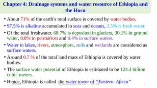
  • 1. Chapter 4: Drainage systems and water resource of Ethiopia and the Horn • About 71% of the earth’s total surface is covered by water bodies. • 97.5% is alkaline accumulated in seas and oceans, 2.5% is fresh water. • Of the total freshwater, 68.7% is deposited in glaciers, 30.1% in ground water, 0.8% in permafrost and 0.4% in surface waters. • Water in lakes, rivers, atmosphere, soils and wetlands are considered as surface waters. • Around 0.7 % of the total land mass of Ethiopia is covered by water bodies. • The surface water potential of Ethiopia is estimated to be 124.4 billion cubic meters. • Hence, Ethiopia is called the water tower of “Eastern Africa” 02/05/2020 Ethiopian Geography and the Horn GeES, MU 1
  • 2. 4.2. Major Drainage System of Ethiopia • The flow of water through well-defined channel is known as drainage. • A drainage system is made up of a principal river and its tributaries. • The major river basins are determined by topographical structures: a) The topography of the outward sloping of the Western and South eastern plateaus b) The structural formation of the Rift Valley with its in-ward- sloping escarpments resulting mainly in an inland drainage system. c) Faults and joints that structurally influence part of the courses of many rivers. 02/05/2020 Ethiopian Geography and the Horn GeES, MU 2
  • 3. • Ethiopia possesses three broadly classified drainage systems namely Western, Southeastern and Rift Valley drainage systems. • Western and the Southeastern drainage systems are separated by the Rift Valley system. 4.2.1. The Western Drainage Systems • It accounts for about 60% of the total water flow of the country. • It drains 40% of total area of the country. • It is made up of 4 major river basins which flow westward except the Ghibe (Omo) basin which flows southward. The remaining are Abay, Baro and Tekeze basins. • This system is called the Mediterranean drainage system because the three basins joining the Nile river in Sudan finally drain to the Mediterranean Sea. 02/05/2020 Ethiopian Geography and the Horn GeES, MU 3
  • 4. • The drainage systems are divided into 3 groups: 1. The Western (Mediterranean) drainage system 2. The Southeastern (Indian Ocean) drainage system 3. The Inland (Rift Valley) drainage system Flows to the Nile Flows to the Somalia Drainage Basins of Ethiopia 02/05/2020 Ethiopian Geography and the Horn GeES, MU 4
  • 5. • The largest river both in volumetric discharge is the Abay. • Abay river basin covers 199,812 km2 , covering parts of Amhara, Oromia and Benishangul-Gumuz regional states. • The river carries 65 % of the annual water flow of the region. • Abay which rises from Lake Tana (its origin from Sekela, Choke mountain) flows 1,450 km and joins the White Nile in Khartoum, Sudan to form the Nile River. • More than 60 streams drains to Abay within elevation ranging between 500 - 4261 m.a.s.l. • The largest tributary in Abay River is Ghilgel Abay (Little Abay). • Tekeze carryies 12 % of the annual water flow of the region. 02/05/2020 Ethiopian Geography and the Horn GeES, MU 5
  • 6. • Tekeze drains 82,350 Km2 of land surface within elevation ranging between 536-4517 m.a.s.l. • It has two main tributaries (Angereb and Goang) which rises in the central highlands of Ethiopia. • It is termed Atbara in Sudan, which is a tributary of the Nile. • The total mean annual flow is 8.2 billion metric cubes (bmc). • The Baro-Akobo and Ghibe / Omo rivers drain the wettest highlands in the south and southwestern Ethiopia. • Baro-Akobo carries 17 % and Ghibe / Omo river carries 6% of the annual water flow. • Ghibe/ Omo river basin drains an area of 79,000 km2 . • Baro Akobo river basin has an area of 75,912 km2 . 02/05/2020 Ethiopian Geography and the Horn GeES, MU 6
  • 7. • Baro Akobo river basin covers parts of BenishangulGumuz, Gambella, Oromia and SNNPR. • The total mean annual flow from the river basin is 23.6 BMC. • The Baro and Akobo river forms the Sobat River in South Sudan. • The Ghibe /Omo River finally empties into the Chew-Bahir at the mouth of Lake Turkana (an elongated Rift Valley lake) forming an inland drainage. 4.2.2. The Southeastern Drainage Systems • It is drained by the southeastern drainage systems. • The basin slopes south-eastwards across large water deficient plains. • The highlands include plateaus of Arsi, Bale, Sidama and Harerghe. • Wabshebelle and Ghenale rivers cross the border into Somalia, carrying 25 % of the annual water flow of Ethiopia. 02/05/2020 Ethiopian Geography and the Horn GeES, MU 7
  • 8. Ghenale River basin  It has an area of 171,042 km2.  It covers parts of Oromia, SNNPR, and Somali regions.  It has fewer tributaries but carries more water than Wabishebelle, reaches the Indian Ocean.  The basin flows estimated to be 5.8 BMC within elevation ranging between 171-4385 m.a.s.l.  When Ghenale River reaches in Somalia, it is named the Juba River. Wabishebelle River basin  It has a total catchment area of 202,697 km2, and largest river in terms catchment area.  It drains parts of Oromia, Harari and the Somali regions.  It is the longest river in Ethiopia.  Its tributaries are left bank and, most of them, are intermittent.  Wabishebelle fails to reach the Indian Ocean where at the end of its journey it flows parallel to the coast before its water disappears in the sands, just near the Juba River. 02/05/2020 Ethiopian Geography and the Horn GeES, MU 8
  • 9. 4.2.3. The Rift Valley Drainage System • It is an area of small amount of rainfall, high evaporation and small catchment area. • The only major river basin is that of the Awash. • Awash river basin has a catchment area of 114,123 km2. • It has an average annual discharge of 4.9 BMC. • It originates from Shewan plateau in central highlands of Ethiopia. • It covers parts of the Amhara, Oromia, Afar, Somali, Dire Dawa ... • It is the most utilized river in the country. • Following the Rift Valley orientation, the Awash flows in a northeast direction. 02/05/2020 Ethiopian Geography and the Horn GeES, MU 9
  • 10. • Awash river has its source from Mecha highlands west Shewa and flows into lake Abe on the Ethio-Djibouti border. • The Afar drainage sub-basin has no stream flow. • It is an area of little rain, very high temperature and very high evaporation. • Lake Afrera and Asale are the only main surface waters in the Awash basin which are not the result of any meaningful surface flow. • The formation Lake Afrera and Asale is related to tectonic activities. • Southern part of the Rift Valley sub-basin is characterized by a number of lakes and small streams. • It is described as lakes region, occupying fault depression. 02/05/2020 Ethiopian Geography and the Horn GeES, MU 10
  • 11. • Important streams drain to the Lakes' basin Meki and Kater flow into Lake Ziway Teggi and Guracha flow into Lake Langano Gidu and Lendi flow into Lake Shalla Bilate, Chidabo and Gelana flow into Lake Abbaya Bullbulla river connects Lake Ziway and Lake Abiyata Horocalo river connects Lake Abiyata and Lake Langano Segen drains into Chew bahir 4.3. Water Resources: rivers, lakes and sub-surface water 4.3.1. The Ethiopian Rivers • Ethiopia is endowed with many rivers. • Majority of the rivers originate from highland areas. 02/05/2020 Ethiopian Geography and the Horn GeES, MU 11
  • 12. Table: Data on major Ethiopian rivers River Catchment Area(km2 ) Annual Volume BMC Terminus/Mouth Major tributaries Abay 199,812 4.5 Mediterranean Dabus, Dedessa, Fincha, Guder, Muger, Jema, Beshilo Wabishebelle 202,697 3.4 Coast of Indian Ocean Ramis Erer, Daketa Fafan Genale Dawa 171,042 6 Indian-Ocean Dawa, Weyb, Welmel, Mena Awash 114,123 4.9 Inland (within Eth) Akaki, Kesem, Borkena, Mile Tekeze 87,733 8.2 Mediterranean Goang, Angereb Gibe (Omo) 79,000 16.6 Lake Turkana Gojeb Baro Akobo 75,912 23.23 Mediterranean Akobo • Ethiopian rivers form 12 major watersheds separating the Mediterranean Sea from the Indian Ocean drainage systems. 02/05/2020 Ethiopian Geography and the Horn GeES, MU 12
  • 13. General characteristics of Ethiopian rivers • Major rivers originate from the highlands. • Majority of Ethiopian rivers are trans-boundary. • The rivers are have extreme seasonal fluctuation due to RF seasonality. • In the wet season, runoff is higher and rivers are full bursting their banks, destroying small bridges, damage roads and flooding low lands. • They became mere trickles of water or even dry up in the dry seasons. • Due to ruggedness, they have rapids and waterfalls along their course. • They have cuts, steep-sided river valleys and deep gorges. • Rivers flow on steep slopes having steep profiles. • Some rivers serve as boundaries, international and domestic administrative units. 02/05/2020 Ethiopian Geography and the Horn GeES, MU 13
  • 14. 4.3.2. The Ethiopian Lakes • Relatively Ethiopia is rich in lakes. • The lakes are the result of tectonic process that took place during Quaternary period of Cenozoic era. • Except few lakes (Tana, Hayik, & Hashege), majority of lakes are located within the Rift Valley System. • Lake Tana, the largest lake, occupies a shallow depression in the highlands. • The Tana depression is believed to be formed following slower sinking and reservoir by lava flow between Gojjam and Gonder massifs. • Ethiopia is gifted with crater lakes; at Bishoftu, Wonchi, Hayk and the Crater Lake on top of Mount Zikwala. • Lake Hashenge is formed on a tectonic basin. • Other types are man-made such as Lakes Koka, Fincha and Melka Wakena, and other lakes dammed following hydroelectric power generation projects. 02/05/2020 Ethiopian Geography and the Horn GeES, MU 14
  • 15. • Cluster of lakes are lined up within Main Ethiopian Rift. • Lake Abaya is the largest of all the lakes in the system. • The southern tip of the Rift Valley forms the marshy land called the Chew Bahir which is drained by Segan and Woito rivers. • Lake Shala and Ziway are the shallowest and the deepest lakes in the central Ethiopian Rift Valley. 02/05/2020 Ethiopian Geography and the Horn GeES, MU 15
  • 16. Major Lakes in Ethiopia Lakes Area (km2 ) Max. Depth(m) Lakes Area (km2 ) Max. Depth(m) Tana 3600 9 Abijata 205 14 Abaya 1162 13.1 Awassa 129 10 Chamo 551 13 Ashenge 20 25 Ziway 442 8.95 Hayk 5 23 Shala 409 266* Beseka 48.5 11 Koka 205 9 02/05/2020 Ethiopian Geography and the Horn GeES, MU 16
  • 17. 4.3.3. Subsurface (ground) water resource of Ethiopia • Climatic and geophysical conditions determine the availability of groundwater resource. • The ground water potential is estimated to be 2.6 - 6.5 BMC. • Other studies believed that Ethiopian groundwater potential is believed to range between 12-30 BMC. 4.4. Water Resources Potentials and Development in Ethiopia 1. Hydro-electric Potential • The exploitable potential of hydroelectric power is 45000 megawatts. • The first hydroelectric power generation plant was installed on Akaki River (Aba Samuel) in 1932. 02/05/2020 Ethiopian Geography and the Horn GeES, MU 17
  • 18. • Grand Ethiopian Renaissance Dam is the largest dam under construction aiming to generate 6400 megawatts (?). • Gilgel Gibe III hydropower project has gone operational generating 1870 megawatts. • Ethiopia is administering 14 hydroelectric power plants constructed on Lake Aba Samuel, Koka, Tis-Abay, Awash, MelkaWakena, Sor, Fincha, Gibe/Omo, Tana Beles and Tekeze, generating close to 4000 megawatts of energy. • The country is exporting electricity to the neighboring countries. • The major problem related to the use of Ethiopian rivers for the generation of hydroelectric power are: The seasonal flow fluctuations. Impact of climate change and variabilities. The severe erosion from the highlands and sedimentation in the reservoirs. 02/05/2020 Ethiopian Geography and the Horn GeES, MU 18
  • 19. 2) For Irrigation and Transportation • In the lowland areas of Ethiopia, the demand for irrigation is high. • Ethiopia’s potential of irrigation is estimated to be 5.3 million hectares. • The Baro-Akobo and Genale Dawa river systems have large irrigation potential compared to other basins. • More than 60% of the area under irrigation so far is located in Rift Valley drainage system. • Majority of hydro-electric reservoirs are multi-purpose and are expected to contribute for irrigation. • Majority of Ethiopian rivers are not suitable for transportation. • The Baro at its lower course is the only navigable river. • Ethiopian lakes are much suitable for transportation than rivers. • Lake Tana and Abaya are the most used for transportation. 02/05/2020 Ethiopian Geography and the Horn GeES, MU 19
  • 20. 3) Fishing and Recreation • Majority of Ethiopian lakes are rich in fish. • The annual production of fish is estimated to be 31.5 thousand tons. • The exploitable potential is larger than the current annual production. • Lake Tana leads the potential by estimated 8,000-10,000 tons per year. • Fish production from Lake Chamo is estimated at 4,500 tons per year. • More than 60% of fish supplies are coming from Main Rift Valley lakes. 02/05/2020 Ethiopian Geography and the Horn GeES, MU 20
  • 21. Some of the problems for fishing in the lakes are: the lakes threatened by sedimentation. invasive species (water hyacinth). over exploitation and expansion of investments around lakes •What makes Ethiopian rivers and lakes important for recreational and tourist attractions? othe existence of variety of fish, birds and other aquatic life forms in the lakes. oThe scenic beauty of the lakes, the hot springs around them. oThe spectacular river gorges and the most impressive waterfalls (eg. Tis-Abay waterfall). 02/05/2020 Ethiopian Geography and the Horn GeES, MU 21
  • 22. Chapter 5: the climate of Ethiopia and the Horn 5.1. Introduction Ethiopia is characterized by wide variety of altitudinal ranges and diverse climatic conditions.  Ethiopia is subjected to large temporal and spatial variations in elements of weather and climate because of its closeness to the equator and the Indian Ocean.  Ethiopian climate is mainly controlled by:  The seasonal migration of the Intertropical Convergence Zone (ITCZ).  Associated atmospheric circulations.  The complex topography of the country. 02/05/2020 Ethiopian Geography and the Horn GeES, MU 22
  • 23. Weather and climate Weather • It is the instantaneous/current state of the atmosphere composing temperature, atmospheric pressure, humidity, wind speed and direction, cloudiness and precipitation. Climate • It is the state of the atmosphere over long time periods. • It considers extremes or variations that may occur beyond the average conditions. Climate is determined by latitude, elevation, nearby water, ocean currents, topography, vegetation, and prevailing winds • The global climate system and any changes that occur within it also influence local climate. 02/05/2020 Ethiopian Geography and the Horn GeES, MU 23
  • 24. Cont’d Expressions of weather • Hotness or coldness • Rainy or cloudiness of air you are feeling on the daily • Sunniness • Windiness or calmness 5.2. Elements and controls of weather and climate • The determining factors are called controls of weather and climate. Elements Controls 1. Temperature 1 Latitude/angle of the Sun 2. Precipitation and humidity 2 Land and water distribution 3. Winds and air pressure 3 Winds and air pressure 4 Altitude and mountain barriers 5 Ocean currents 02/05/2020 Ethiopian Geography and the Horn GeES, MU 24
  • 25. 5.2.1. Controls of weather and climate A. Latitude • It is the distance of a location from the equator. • The sun shines on equator for more hours in the year than anywhere else. • Moving away from the equator towards the poles, less solar insolation is received during the year and the temperature become colder. • Ethiopia’s latitudinal location has bearings on its temperature. Latitudinal location of Ethiopia and the Horn resulted: • High average temperatures • High daily and small annual ranges of temperature • No significant variation in length of day and night between summer and winter. 02/05/2020 Ethiopian Geography and the Horn GeES, MU 25
  • 26. B. Inclination of the Earth's Axis • The earth’s rotation axis makes an angle of 66 ½ ° with the plane of its orbit around the sun, or about 23 ½ ° from the perpendicular to the ecliptic plane. • The inclination determines the location of the Tropics of Cancer, Capricorn and the Arctic and Antarctic Circles. • As the earth revolves around the sun, this inclination produces a change in the directness of the sun's rays, which in turn causes the directness of the sun and differences in length of day and seasons. Equinoxes and Solstices • An equinox is the instant of time when the sun strikes the plane of the equator. • During this passage the length of day and night are equal. • Revolution of the earth along its orbit, the inclination of its axis from the plane of that orbit, and the constant position (parallelism) of the axis causes seasonal changes in the daylight and darkness periods. 02/05/2020 Ethiopian Geography and the Horn GeES, MU 26
  • 27. cont’d •Equinox appears twice a year. Two major equinoxes: I. The Vernal (spring) equinox  It is the day when the point of verticality of sun’s rays crosses the equator northwards.  This equinox experiences in Northern Hemisphere when the sun is exactly above the equator.  During this period, the length of day and night are equal.  Vernal (spring) equinox marks the beginning of spring season. March 21 marks the offset of the vernal equinox. II. The Autumn equinox: •It appears to happen when the sun crosses equator giving approximately equal length between day and night. • It appears to happen when the visible sun moves south across the celestial equator on 23rd of September. •It marks the beginning of Autumn season. 02/05/2020 Ethiopian Geography and the Horn GeES, MU 27
  • 28. Solstice • It is an event when the overhead sun appears to cross northern/southern points. • It results in unequal length of days and nights in the hemispheres. • Both hemispheres during this event has either the most or least sunlight of the year. I. The summer Solstice On June 21st, the northern hemisphere has maximum tilt towards the sun experiencing longest daylight of the year. It is the astronomical first day of summer in the Northern Hemisphere. The sun is at its highest position in the noonday sky, directly above 23 ½ in the Tropic of Cancer. II. The winter solstice 22nd of December is the day when the maximum southward inclination is attained in the Southern Hemisphere. The sun travels shortest length causing longest night and shortest daylight. In the Northern Hemisphere, it occurs when the sun is over the Tropic of Capricorn, which is located at 23 ½ ° south of the equator. 02/05/2020 Ethiopian Geography and the Horn GeES, MU 28
  • 29. The apparent path of the sun at different latitudes 02/05/2020 Ethiopian Geography and the Horn GeES, MU 29
  • 30. C. Altitude • It is the height of location above the sea level. • There is a general decrease in temperature with increasing elevation. • The average rate at which temperature changes per unit of altitudinal change is known as lapse rate. • The lapse rate is limited to the troposphere/lower layer of the atmosphere. • The normal lapse rate is 6.5°C per km rise in altitude. Types of lapse rate: i. Dry adiabatic laps rate ii. Wet Adiabatic laps rate iii. Environmental lapse rate or Atmospheric lapse late 02/05/2020 Ethiopian Geography and the Horn GeES, MU 30
  • 31. 5.3. Spatiotemporal patterns and distribution of temperature and rainfall in Ethiopia 5.3.1. Spatiotemporal Distribution of Temperature Temperature of Ethiopia and the Horn is determined by altitude (has greater influence), humidity, and winds. The spatial distribution of temperature in Ethiopia is primarily determined by altitude and latitude. Every part of Ethiopia experiences overhead sun twice a year because of the location at close to equator, a zone of maximum insolation. However, tropical temperature conditions have no full spatial coverage in Ethiopia.  They are limited to the lowlands in the peripheries. Temperature decreases towards the interior highlands. 02/05/2020 Ethiopian Geography and the Horn GeES, MU 31
  • 32. Mean annual temperature varies from over 30 0c in the tropical lowlands to less than 100c at very high altitudes (Bale Mountains Vs Afar Depression).  Environmental influences have traditional expressions in Ethiopia and there are local terms denoting temperature zones. Table : Temperature versus altitude Altitude (meter) Mean ann temp (0C) Description Local Equivalent 3,300 and above 10 or less Cool Wurch 2,300 - 3,300 10 – 15 Cool Temperate Dega 1,500 - 2,300 15 – 20 Temperate Woina Dega 500 - 1,500 20 – 25 Warm Temperate Kola below 500 25 and above Hot Bereha 02/05/2020 Ethiopian Geography and the Horn GeES, MU 32
  • 33. • The temporal distribution of temperature is characterized by extremes due to latitude and cloud cover. • However, some parts of the country enjoy a temperate climate. • In Ethiopia, as in all places in the tropics, the air is frost free and changes in solar angles are small making intense solar radiation. • Ethiopia’s daily temperatures are more extreme than its annual averages. • Daily maximum temperature varies from 37 oC over the lowlands and southeast to 10 -15 oC over the northwestern and southwestern highlands. • But in the monthly averages, variation is minimal and the annual range of temperature is small. • In Ethiopia, temperature shows seasonal variations. Example: months from March to June have records of highest temperatures. 02/05/2020 Ethiopian Geography and the Horn GeES, MU 33
  • 34. • Low temperatures are recorded from November to February. • There is a slight temperature increase in summer. • Southern part receives highest records of temperature in autumn and spring following the relative shift of the sun. • In the northern, summer season is characterized by higher temperature. • Certain seasons should have special considerations. For instance, the southern and southwestern highlands experience reduced temperature. • This is because the temperature and the amount of energy reaching the surface is related with the directness of the sun. • The direction of rain bearing winds (leeward or windward side) determines the temperature variations in mountainous regions. 02/05/2020 Ethiopian Geography and the Horn GeES, MU 34
  • 35. 5.3.2. Spatiotemporal Distribution of Rainfall • Rainfall system of Ethiopia is complexities. • The rainfall system is characterized by spatial and temporal variabilities. • Rainfall is influenced by the position of Intertropical Convergence Zone (ITCZ). • The convergence of Northeast Trade winds and the Equatorial Westerlies forms the ITCZ, which is a low-pressure zone. • The inter-annual oscillation of the surface position of the ITCZ causes a variation in the wind flow patterns. • As the shift takes place, equatorial westerlies from the south and southwest invade most parts of Ethiopia bringing moist winds. 02/05/2020 Ethiopian Geography and the Horn GeES, MU 35
  • 36. • Winds decrease the length of rainy seasons and magnitudes. • The shift takes place when the trade winds from the north retreat giving the space for equatorial westerlies in July causing variability and seasonality. • The ITCZ shifts towards south of equator in January, then Northeast Trade Winds carrying non-moisture-laden. • In January, Afar and parts of Eritrean coastal areas experience rainfall. • In March and September, the ITCZ shifts towards equator. • During this time, the central highlands, southeastern highlands and lowlands receives rainfall as the south easterlies bring moist winds. 02/05/2020 Ethiopian Geography and the Horn GeES, MU 36
  • 37. Seasonal or Temporal Variabilities • The rainfall is highly variable in amount and distribution across seasons. • The seasonal and annual rainfall variations are results of the macro-scale pressure systems and monsoon flows which are related to the changes in the pressure systems. • The temporal variabilities of rainfall are characterized by; i. Summer (June, July, August) • From mid-June to mid-September, majority of Ethiopian regions, receive rainfall during the summer season as the sun overheads north of the equator. • High pressure cells develop on the Atlantic and Indian Oceans around the tropic of Capricorn, but the Indian Ocean is source of rainfall. • Ethiopia and the Horn come under the influence of the Equatorial Westerlies (Guinea monsoon) and Easterlies. • Hence, Guinea monsoon and South easterly winds are responsible for the rain. 02/05/2020 Ethiopian Geography and the Horn GeES, MU 37
  • 38. ii. Autumn (September, October and November)  Autumn is the season of the year between summer and winter.  The exact position of the ITCZ changes over the course of the year, oscillating across the equator. The ITCZ shifts towards the equator weakening the equatorial westerlies.  The south easterlies from Indian Ocean showers the lowlands in southeastern. iii. Winter (December, January and February) • The overhead sun is far south of equator in winter. • Northeasterly winds originating from the landmass of Asia dominantly prevail Ethiopian landmass. • It has no significant coverage compared to other seasons. • The northeasterly winds crossing the Red Sea carry very little moisture and supplies rain only to the Afar lowlands and the Red Sea coastal areas. 02/05/2020 Ethiopian Geography and the Horn GeES, MU 38
  • 39. iv. Spring (March, April and May) • The noonday sun is shining on the equator while shifting north from south. • The shift of the ITCZ, results in longer days and more direct solar radiation providing warmer weather for the northern world. • Then, the effect of the northeast trade wind is very much reduced. • Conversely, the southeasterlies from the Indian Ocean provide rain to the highlands of Somalia, and to the central and southeastern lowlands and highlands of Ethiopia. 02/05/2020 Ethiopian Geography and the Horn GeES, MU 39
  • 40. Ethiopia has four rainfall regions: I. Summer rainfall region  In almost all parts of the country, except southeastern and northeastern lowlands.  Two dry and wet summer rainfall regions. II. All year-round rainfall region It has many rainy days than any part of the country. It is a rainfall region in the southwestern part of the country. Average rainfall= 1,400 to over 2,200 mm/year. III. Autumn and spring rainfall regions  South eastern lowlands of Ethiopia  Average rainfall = <500 to 1,000 mm. IV. Winter rainfall region  Receives rain from the northeasterly winds.  Some parts of the Afar region. 02/05/2020 Ethiopian Geography and the Horn GeES, MU 40
  • 41. 5.4 Agro-ecological Zones of Ethiopia • Ethiopia possesses diverse agro-climatic zones, in terms of temperature. • Five major climatic zones A. Bereha - Kolla  In south, southeast, west and northeastern part of Ethiopia. B. Woina Dega  Suitable for majority of crops grown in Ethiopia. C. Dega  Long inhabited and has dense human settlement due to reliable rainfall for agriculture and absence of vector-borne diseases-malaria. D. Wurch  Mountain systems of Ras Dashen, Guna, Megezez in North Shoa, Batu, Choke, Abune Yoseph etc. 02/05/2020 Ethiopian Geography and the Horn GeES, MU 41
  • 42. Table: Agro Ecological Zones of Ethiopia Zones Altitude (m) Mean annual rainfall (mm) Length of growing periods (days) Mean annual temperature (0C) Area share (%) Wurch (cold to moist) >3,200 900-2,200 211–365 Below 10 0.98 Dega (cool to humid) 2,300 - 3,200 900-1,200 121–210 ≥11.5–17.5 9.94 Weyna Dega (cool sub humid) 1,500 - 2300 800-1,200 91–120 >17.5 – 20.0 26.75 Kola (Warm semiarid) 500 - 1,500 200-800 46–90 >20.0 – 27.5 52.94 Berha (Hot arid) <500 Below 200 0–45 >27.5 9.39 02/05/2020 Ethiopian Geography and the Horn GeES, MU 42
  • 43. • Traditional Agro Ecological Zones of Ethiopia 02/05/2020 Ethiopian Geography and the Horn GeES, MU 43
  • 44. 5.5. Climate Change/Global Warming: causes, consequences and response mechanisms • Climate change is natural and has been there. So why is it our concern now? • It is a change in the state of the climate. • It is any change in climate over time due to natural variability or human activities. 5.5.1 Current Trends of Climate in Ethiopia • Ethiopian climate experiences extremes: drought and flood. • She ranked 5th out of 184 countries in terms of its risk of drought. • About 12 extreme drought events were recorded between 1900 and 2010, 7 of the drought events occurred since 1980. • The severe drought of 2015/2016 was exacerbated by the strongest El Nino, causing successive harvest failures and widespread livestock deaths. 02/05/2020 Ethiopian Geography and the Horn GeES, MU 44
  • 45. Trends in temperature variability • Over the last decades, Ethiopia has experienced climatic changes. • Mean annual temperature has shown 0.2°C to 0.28°C rise per decade. • A rise in average temperature of about 1.3°C has been observed in 1960 -2006. • Higher rise in temperature was noted in drier areas in July-September. • The number of ‘hot day’ and ‘hot night’ has shown increment. • The minimum temperature has increased with 0.37°C to 0.4°C per decade. Global mean temperature anomaly: Orange (land) and blue (sea) 02/05/2020 Ethiopian Geography and the Horn GeES, MU 45
  • 46. Trends in rainfall variability • Precipitation has remained stable over the last 50 years. • However, these do not reflect local conditions which are extremely divergent. • The natural variability in rainfall makes it difficult to detect long-term trends. • Rainfall variability is increasing (and predictability is decreasing). • Total average rainfall is declining: southern, south-western and south-eastern in 1975 and 2010, stong implications for crop production. • Changes in temperature and rainfall increase the extreme events. • Major floods have led to loss of life and property in numerous parts of the country. • Warming has exacerbated droughts, and desertification in the lowlands is expanding. 02/05/2020 Ethiopian Geography and the Horn GeES, MU 46
  • 47. 5.5.2. Causes of climate change A. Natural causes • Earth orbital changes • Energy Budget • Volcanic eruptions B. Anthropogenic causes • Human activities • The warming of earth planet in the past 50 years is majorly driven by human activities. • Decomposition of wastes in landfills, agriculture, ruminant digestion and manure management, synthetic compounds manufacturing, clearing of land for agriculture and industrial activities have increased concentrations of greenhouse gases. 02/05/2020 Ethiopian Geography and the Horn GeES, MU 47
  • 48. 5.5.3. Consequences of climate change  Impacts on human health • Heat related mortality and morbidity. • Greater frequency of infectious disease epidemic.  Impact on water resources • Melting of snow and glaciers increases rise in sea level, drought and floods, distorts wind flow pattern and decreases water table.  Impact on agriculture • Increases physiological stress and fodder quality and availability.  Impact on ecosystem • Success of species, population, and community adaptation are affected 02/05/2020 Ethiopian Geography and the Horn GeES, MU 48
  • 49. 5.5.4. Climate Response Mechanisms Three major response mechanisms to climate change mitigation, adaptation and resilience. A. Mitigation and its strategies  Mitigation refers to action that is taken to reduce and control greenhouse gas emissions changing the climate.  The strategies are reducing the flow of heat trapping greenhouse gases into the atmosphere, either by reducing sources of these gases or enhancing the “sinks” that accumulate and store these gases. Examples: • Practice energy efficiency. • Increase the use of renewable energy such as solar. • Efficient means of transport implementation: electric public transport, bicycle, shared cars etc 02/05/2020 Ethiopian Geography and the Horn GeES, MU 49
  • 50. B. Adaptation and its strategies • Adaptation is defined as adapting to life in a changing climate. • It involves adjusting to actual or expected future climate. • It encompasses making the most of any potential beneficial opportunities associated with climate change. • The goal is to reduce our vulnerability to the harmful effects of extreme weather events or food insecurity. Example: • Building flood defenses • Planning for heatwaves and higher temperatures • Installing water-permeable pavements to better deal with floods and storm water. • Improving water storage and use are some of measures taken by cities and towns. • Landscape restoration and reforestation. • Flexible and diverse crop cultivation. • Preventive and precautionary measures (evacuation plans, health issues, etc.). 02/05/2020 Ethiopian Geography and the Horn GeES, MU 50
  • 51. Chapter 6: Soils, Natural Vegetation and Wildlife Resources of Ethiopia and the Horn 6.1. Introduction • The past geological process and varied climatic events ensued Ethiopia to have varied soil and biological diversity. • The formation and spatial variabilities of soils is related to topographic and climatic factors, parent material (rocks) and land use. • The distribution of wildlife and natural vegetation is controlled by many factors important among which are climate, soil types, drainage, etc. • Ethiopia possess unique and characteristic fauna and flora with a high level of endemicity. • However, manmade as well as natural problems are threatening their availability and distribution. 02/05/2020 Ethiopian Geography and the Horn GeES, MU 51
  • 52. 6.2. Ethiopian soils: types, degradation and conservation 6.2.1. Definition of soil • Soil is a composition of mineral particles, organic matter and living organisms in dynamic equilibrium. • Its variability reflects the parent material from which the soil was formed over very long periods of time and the environment. • It consists of weathered mineral materials (45%), organic matter (5%), air (20-30%) and water (20-30%). • The formation of soil depends on the parent material, climate, topography, living organism and time. 02/05/2020 Ethiopian Geography and the Horn GeES, MU 52
  • 53. What is weathering ? • It is the breakdown of rocks at the surface, by the action of rainwater, extremes of temperature, and biological activity. • It disintegrates the inorganic substances (rocks) of soils. Three weathering involving in soil formation: A. Mechanical (physical) weathering It causes decrease in size without appreciably altering composition. Example: Abrasion B. Biological weathering It is weakening and subsequent disintegration of rock by plants, animals and microbes. C. Chemical weathering It is modification of the chemical and mineralogical composition of the weathered material. Example: hydrolysis, oxidation, reduction, hydration, carbonation, and solution. 02/05/2020 Ethiopian Geography and the Horn GeES, MU 53
  • 54. Properties of soil  Soils have two properties: A. Physical properties • They are influenced by composition and proportion of major soil components: texture, structure and porosity. B. Chemical properties  Soil chemistry is the interaction of various chemical constituents that takes place among soil particles: availability of minerals, electrical conductivity and soil pH. 6.2.2. Major Soil Types in Ethiopia • Soils are basically derived from crystalline, volcanic and mesozoic sedimentary rocks. • Hence, some of the soil divisions are based on the geologic structure. 02/05/2020 Ethiopian Geography and the Horn GeES, MU 54
  • 55. Cont’d • There are soils formed due to long waited deposition of sediments. • FAO has identified 18 soil associations in Ethiopia at scale of 1:2,000,000. • 11 soil associations cover about 87.4 % of the land area. Six major soils groups in Ethiopia 1.Nitosols and Acrisols Nitosols They are develop on gently sloping ground.  They are weathered soils but far more productive than other tropical soils. They are associated with highlands with high rainfall.  They are originally formed on forest covered areas. They are characterized by soil leaching: poor in soluble minerals like potassium, calcium etc.; and rich in non-soluble minerals like iron and aluminum. 02/05/2020 Ethiopian Geography and the Horn GeES, MU 55
  • 56. • Nitosols are found in Western highlands (Wellega), Southwestern highlands (Kaffa, Illuababora), Southern highlands, Central highlands, and Eastern highlands. Acrisols • They are inherently infertile soils of the tropics. • They are degraded chemically and organically very quickly when utilized. • They have very low resilience to degradation and moderate sensitivity to yield decline. • In Ethiopia, it has lost the base nutrients and have low productive capacity. • They are found along with nitosols in some pockets of southwestern highlands of Ethiopia where there is high rainfall. 02/05/2020 Ethiopian Geography and the Horn GeES, MU 56
  • 57. 2. Vertisols  They are heavy clay soils with a high proportion of swelling clays when wet, and cracks when dry.  They are extremely difficult to manage (hence easily degraded).  They have very high natural chemical fertility.  They develop on volcanic plateau basalt, trachyte and pyroclastic materials, sedimentary rocks, colluvial slopes and alluvial plains.  They are soils of highlands and moderate climates.  They are found in parts of northwestern highlands, central highlands and southeastern highlands (especially in Gojjam, Shewa, Arsi, Bale and central Hararghe). 02/05/2020 Ethiopian Geography and the Horn GeES, MU 57
  • 58. 3. Lithosols, Cambisols and Regosol They are mostly found in rugged topography and steep slopes. They are young, shallow and coarse textured. They have low water holding capacity. They are found in areas of low rainfall. They have limited agricultural use. They are found in Central Highlands, Rift Valley Escarpments and highlands in of western Hararghe. Regosol and Lithosols are found in the Danakil and eastern Ogaden. 4. Xerosols, Yermosols and Solanchaks • They are soils of desert/dry steppe soils in arid and semiarid areas. • They have poor humus content and nitrogen. • They are rich in phosphorus and potash and can be very fertile if irrigated. 02/05/2020 Ethiopian Geography and the Horn GeES, MU 58
  • 59. Xerosols  They have low organic content.  They are extremely subjected to wind erosion and soluble salts.  They are found in Ogaden and northeastern escarpments. Yermosols  They are drier and more problematic than Xerosols. Solanchaks  They are saline soils which develop in areas of high evaporation and capillary action.  They are badly managed irrigation schemes may turn soils into solonchaks. NB: • Yermosols and Solonchaks cover the Ogaden and Afar plains 02/05/2020 Ethiopian Geography and the Horn GeES, MU 59
  • 60. 5. Fluvisols They are formed due to deposition of eroded materials from highlands. They develop on flat or nearly flat ground, on recent alluvial deposits. They are associated with fluvial (river), marine (sea) and lacustine (lake) deposits, but are highly variable. They are found in lower regions of rivers like Omo, Awash, Abay and the plains of Akobo and Baro Rivers. They are suitable for intensive agriculture (large-scale irrigation ) as they develop on flat ground, deposition sites, associated with water. 6. Luvisols They develop in areas where wet and dry seasons occur in alternation. They have good chemical nutrients >> agricultural soils in the tropics They found in Lake Tana area, parts of Northern, Central and Eastern Highlands, parts of Southern lowlands. 02/05/2020 Ethiopian Geography and the Horn GeES, MU 60
  • 61. • Soil types of Ethiopia 02/05/2020 Ethiopian Geography and the Horn GeES, MU 61
  • 62. 6.2.2. Soil degradation • Soil degradation is a change in soil status resulting in a diminished capacity of the ecosystem to provide goods and services. • It is a deterioration of physical, chemical & biological properties of soil. • It is a critical and growing global problem. • It is a major concern for at least two reasons: 1) It undermines the productive capacity of an ecosystem. 2) It affects climate through alterations in water and energy balances and disruptions in cycles of carbon, nitrogen, sulfur, and other elements. Three major types of soil degradation i) Physical degradation: the deterioration of the physical properties of soil. • It includes compaction: densification of soil is caused by the elimination or reduction of structural pores. • Soils prone to compaction are susceptible to accelerated runoff and erosion. 02/05/2020 Ethiopian Geography and the Horn GeES, MU 62
  • 63. • Soil erosion is a three-phase process consisting of the detachment of individual soil particles, transportation and deposition. II. Biological degradation  It results in reduction in soil organic matter content, decline in biomass carbon, and decrease in activity and diversity of soil fauna.  It is more severe in the tropics than in the temperate zone – due to high soil and air temperatures. iii. Chemical degradation • It is caused by nutrient depletion, excessive leaching of cat-ions in soils with low-activity clays - reduce soil pH, buildup of toxic chemicals and elemental. • Causes of soil degradation include natural and Human-induced. • Topographic and climatic factors includes steep slopes, frequent floods, storms and high-velocity wind, high-intensity rains and drought. 02/05/2020 Ethiopian Geography and the Horn GeES, MU 63
  • 64. 6.2.3. Soil erosion control measures A. Biological control measures • They include vegetative strips, plantation, and reforestation. • They can prevent splash erosion and reduces the velocity of surface runoff. • They increase surface roughness which reduces runoff and increases infiltration. B. Physical control measures • They are used to control the movement of water and wind. Example: • terracing, check dams, gabion, trenches, contour ploughing, soil bunds etc. 02/05/2020 Ethiopian Geography and the Horn GeES, MU 64
  • 65. 6.3. Natural Vegetation of Ethiopia 6.3.1. Introduction • Natural vegetation refers to a plant cover that develops with little or no human interference. • Controlling factors includes climate, soil types and drainage. • Temperature and precipitation affect the spatial distribution. • The characteristics of vegetation are determined by elevation and rainfall. • In lowlands, xeromorphic plants are adapted to drought and high temperatures. • Highlands (up to 3000 m) have adequate moisture a variety of forests. • Ethiopia possesses an estimated number of 6000 species of higher plants of which 10% are endemic. 02/05/2020 Ethiopian Geography and the Horn GeES, MU 65
  • 66. 6.3.2. Major Natural Vegetation Types of Ethiopia • We classify the vegetation belts of Ethiopia into 5 groups: 1. Afro-alpine and sub-afro alpine region • High mountain vegetation is similar to the Alpine vegetation in temperate regions. • Ethiopia has the largest extent of Afro-alpine and sub afro-alpine habitats in Africa. • They are found on mountains having an elevation ranging between 3,200 and 4,620 m asl. • The Afro-alpine habitat covers 1.3% of the total landmass of Ethiopia. • The region is found at very high altitudes (4,000 – 4,620 m). • The climate of Afro-alpine ecosystems is controlled by latitude and altitude. 02/05/2020 Ethiopian Geography and the Horn GeES, MU 66
  • 67. • The annul precipitation which ranges between 800 and 1,500 mm, is mostly in the form of sleet/snow. • Soils in this ecosystem are mostly shallow and eroded. • Bale and Semien mountains are typical examples of afro-alpine vegetations. • Vegetation in the Afro-alpine region consists of tussock grasslands, scrub, scattered mosses and lichens while the Sub-afro alpine region is dominated by woodland, degraded to scrub stages and wet grasslands. • Lobelia rhynchopetalum (giberra) and Erica arborea (Asta) are some of the dominant species in the Afro-alpine and sub-afro alpine regions, respectively. 02/05/2020 Ethiopian Geography and the Horn GeES, MU 67
  • 68. 2. Forest Region • Forest is a complex ecosystem consisting predominantly of trees that shield earth and support numerous life forms. • They are characterized by variation in mean annual rainfall: 200 and 2,200 mm. • These wide variations in rainfall and altitude result in two broad classification of forests: highlands and Lowland forests. • Highland forests include Hagenia Abyssinia (Kosso), Juniper procera (tid), Arundinaria Alpina(kerkha), Podocarpus falcatus (zigba), Aningeria adolfi-friedericii (keraro) and Olea africana (Weyra). • Lowland forests includes baphia. • Gallery (riverine) forests stretch along the banks of the lower courses of rivers. • Riverine forests are classified as lowland forests found in the banks of Awash, Wabishebelle, Ghenale etc. • Dominant species include Ficus sur (sholla) and different kinds of acacia trees. 02/05/2020 Ethiopian Geography and the Horn GeES, MU 68
  • 69. Cont’d 3. Woodland Savannah Region • They are found in areas of wide altitudinal ranges (250 to 2,300 m). • The large part of this region is found at a lower elevation and in a drier environment. • The plants in the woodland savannah are known for their xeromorphic characteristics like shading of leaves during the dry season. • The characteristics of vegetation types between savannahs and woodlands. • Woodland savannah can be classified into three divisions: a) Juniper procera (tid) is dominant species. The difference is in height: 3 - 45 meters tall in the forests and 10 -15 meters in the woodlands. b) Acacia woodlands are dominated by trees and shrubs, which belong to the 'Acacia‘: Acacia etbaica (grar),Acacia mellifera (Konter). c) Mixed deciduous woodlands are most of the trees in mixed deciduous woodlands shed their leaves during the dry season. 02/05/2020 Ethiopian Geography and the Horn GeES, MU 69
  • 70. 4. Steppe and Semi Desert Regions • They are common in the arid and semiarid parts of the country. • The steppe gets a mean annual rainfall of 100 to 550 mm as compared to 50 to 300 mm for the semi desert areas. • Even though there is a variation in the degree of alkalinity and salinity, soils in both regions are alkaline and saline. • Xerophytic plants (i.e. drought-resisting plants) are the dominant vegetations. • Short shrubs, scattered tufts of grass species and a variety of acacias are some of the examples. • Where there are moist soils, rich vegetation of acacia and palm trees may be observed. • Trees are restricted to fringes along watercourses. 02/05/2020 Ethiopian Geography and the Horn GeES, MU 70
  • 71. 6.3.3. Natural vegetation Degradation • Ethiopia's forest resources have been disappearing due to: 1. Clearing of forests for cultivation. 2. Timber exploitation practices. 3. Charcoal burning and cutting for fuel. 4. Extensions of coffee and tea production areas. 5. Overgrazing 6. Expansion of settlements, and clearing for construction. 6.3.4. Natural Vegetation Conservation • There are three main approaches of biodiversity conservation: a) Protection: sanctuaries, national parks, and community conservation areas. b) Sustainable forest management: sustainable harvesting of forest products to provide a source of financial income. c) Restoration or rehabilitation: recovery of a deraded forest to improve ecosystem services. 02/05/2020 Ethiopian Geography and the Horn GeES, MU 71
  • 72. 6.4. Wild Life/wild animals in Ethiopia • Ethiopia possess unique and characteristic fauna with a high level of endemicity. • She has about 860 avian species, 279 species of mammals, 201 species of reptiles, 23 species of amphibians, and 150 freshwater fish. • A total of 279 mammalian species of which 31 are endemic are known to occur in Ethiopia. • Endemic species require urgent conservation action: Example: Walia Ibex (Capra walie), Gelada Baboon (Theropithecus gelada), Mountain Nyala (Tragelaphus buxtoni), Ethiopian Wolf (Canis simensis), Starck s Hare (Lepus starcki). ‟ • The main wild life concentrations occur in the southern and western parts. 02/05/2020 Ethiopian Geography and the Horn GeES, MU 72
  • 73. 4.4.1 Major groupswild Life/wild animals • Wild animals in Ethiopia can be classified into five major groups: 1) Common wild animals (found in many parts of the country (e.g. hyenas, jackals). 2) Game (lowland) animal, (herbivores like giraffes, wild asses, zebras etc. and carnivores like lions, leopards, and cheetahs). 3) Tree animals or arboreals (monkeys, baboons). 4) A variety of birds in the Rift Valley lakes. 5) Rare animals (gelada baboon and Semien fox) scattered in highlands; walia- ibex in the Semien Massifs, Nyala in the Arsi Bale massifs). 6.4.2. Wildlife Conservation • The importance of wildlife can be categorized as ecological importance, economic importance, investigatory importance, conservation of biological diversities etc. 02/05/2020 Ethiopian Geography and the Horn GeES, MU 73
  • 74. • Wild animals can be used for: scientific and educational researches (for medical and environmental studies). physical and mental recreation (aesthetic value). promotion of tourism (economic value). potential for domestication and maintaining ecological balance. • To prevent the destruction of wildlife, a total area of nearly 100,000 Km2 of national parks, sanctuaries, community conservation areas, botanical gardens, wildlife reserves are established in different part of the country. • In Ethiopia, there are: 21 major national parks, 2 major wildlife sanctuaries, 3 wildlife reserves, 6 community conservation areas, 2 wildlife rescue centres, 22 controlled hunting areas, 2 botanical gardens, and 3 biosphere reserves 02/05/2020 Ethiopian Geography and the Horn GeES, MU 74
  • 75. • Spatial distribution of National Parks (four national parks are not mentioned) 02/05/2020 Ethiopian Geography and the Horn GeES, MU 75
  • 76. • Some national parks are unique in their wild animals they have: a) Abiyatta-Shalla lakes National Park: is a place of bird sanctuary such as flamingos and pelicans. b) Omo, Mago, and Gambela National Parks have hippopotamus and crocodiles in rivers and lakes. c) Semien and Bale Mountains National Parks have rare animals like Walia ibex, Semien fox, gelada baboon and Nyala. 6.4.3. Challenges of wildlife conservation in Ethiopia • Limited awareness on the importance of wild life. • Expansion of human settlement in protected areas. • Conflict over resource and overgrazing. • Illegal wildlife trade and excessive hunting. • Tourism and recreational pressure. • Mining and construction material extraction and forest fire. 02/05/2020 Ethiopian Geography and the Horn GeES, MU 76