SlideShare a Scribd company logo
1 of 10
Download to read offline
IOSR Journal of Applied Geology and Geophysics (IOSR-JAGG)
e-ISSN: 2321–0990, p-ISSN: 2321–0982.Volume 3, Issue 6 Ver. I (Nov. - Dec. 2015), PP 01-10
www.iosrjournals.org
DOI: 10.9790/0990-03610110 www.iosrjournals.org 1 | Page
Resistivity Imaging of Shallow Sediments within University of
Maiduguri Campus, Northeast Nigeria
S. C. Alkali, A. A. Zarma
Department of Geology, University of Maiduguri, Nigeria
Abstract: Electrical resistivity imaging within University of Maiduguri campus shows varying resistivity values
and thicknesses for shallow sediments from one profile line to another. Sequence stratigraphy of the sediments
indicates they were deposited at different times and varying conditions. Structure of the medium of deposition
conditioned the lithological structures of the sediments. Basin or bowl-shapes of some resistivity structures are
characteristics of some gravelly and clayey sediments. In most cases where such structures are encountered,
gravels seem to host sands; while clays are located at the central parts. This situation may suggest that the
sediments were deposited at the same time, where heavier ones settled to the bottom of the stratigraphy.
Sometimes clayey sediments host sandy sediments; a situation that may be associated with different times of
deposition. Some sediments were laid horizontally, some inclined and others nosed into overlying ones.
Majority of the resistivity images indicate clayey sediments occupying the basal resistivity units. Lower
resistivity values associated with some clayey sediment suggest high degree of saturation. The water might have
been derived through infiltration of the overlying porous sediments. The clays may be followed upwardly by
sands, while gravels sometimes form the capping sediments. Few resistivity profiles host the three sediments at
the bottom of the resistivity structures. Stratigraphic thicknesses for the sediments vary both laterally and
vertically. These are associated with the structure of the medium and prevailing conditions at the time of
deposition.
Keywords: Dipole-dipole, profile, sediments, resistivity, imaging, structures
I. Introduction
The area is situated in Maiduguri metropolitan area in North Eastern Nigeria between latitudes 11o
48’ -
11o
55’ N and longitudes 13o
04’ E - 13o
14’ E (Fig. 1).
Fig. 1 Location of resistivity profiles
Maiduguri area lies on a semi arid zone of long dry season from October to April and short rainy
season that lasts from May to September. Rainfall is generally low, averaging 405 mm. The temperature ranges
from 24 - 40 
C and more during the months of April - June. Dry dusty harmattan blows off the desert during
Resistivity Imaging of Shallow Sediments within University of Maiduguri Campus, Northeast Nigeria
DOI: 10.9790/0990-03610110 www.iosrjournals.org 2 | Page
the months of December - February. Evaporation is about 1600 mm. Maximum precipitation is from 650 - 700
mm. Effective precipitation is appreciably preceded by high rate of evaporation.
The University of Maiduguri Campus is situated on the Chad Basin sediments. The campus area is
relatively flat, but slopes gently away from the Bama Ridge area in the south towards the north. The soil consists
of clays, sands and gravels. Shallow subsurface sediments considered in the survey comprise the superficial
sediments and drift deposited by the activities of surface water runoff and winds. These sediments post-date the
well known stratigraphy of the Chad Formation which is of plio-pleistocene age. Recent sand dunes
accumulated in the Chad Basin and several ancient dune systems may be observed.
The present work is aimed at determining 2D resistivity structures of shallow sediments within the
University of Maiduguri Campus using dipole dipole arrangement.
II. Geology of the study area
The area is underlain by sediments of the Chad Formation (Fig. 2). The Chad Formation overlies the
Kerri Kerri Formation of Tertiary period and it is in turn overlain by recent alluvial deposits (Barber, 1965).
These sediments were deposited during the end of the Cretaceous period and the beginning of the Tertiary
period. The formation covers an area of about 23,000 km2
in parts of Bauchi, Borno, Jigawa, Kano and Yobe
States in Nigeria. The sediments are poorly sorted and vary in grain size and colour; finer grains exhibit
fluviatile depositional patterns.
Fig. 2 Geological map of part of Borno State showing the study area
Deposition of the Chad Formation commenced after the regression of the sea southwards at the end of
Cretaceous time (Barber and Jones, 1960). Boreholes’ drilling in Maiduguri has revealed three distinct zones of
sandy sediments separated by clay deposits. The sediments show both lateral and vertical heterogeneities.
III. Materials and methods
The survey was designed to image/map subsurface sediments from only a few metres in depth. ABEM
Terrameter was used to acquire the data. The survey was conducted in the month of July when the rainy season
has fully set in, which minimized the fatigue of wetting the electrodes. Eighteen profile lines spanning from 100
- 110 m, and covering almost the entire University Campus area were established. The lines were coordinated
with Global Positioning System at the beginning of the traverses.
The spacing between the current electrodes pair, C2-C1 given as “a” was the same as the distance
between the potential electrodes pair P1-P2 (Fig. 3). The factor marked as “n” is the ratio of the distance
between the C1 and P1 electrodes to the C2-C1 (or P1-P2) dipole length “a”. For this array, the “a” spacing was
initially kept fixed at the smallest unit electrode spacing and the “n” factor was increased from 1 to 2 to 3 until
up to about 6 in order to increase the depth of investigation (Loke, 2000).
Resistivity Imaging of Shallow Sediments within University of Maiduguri Campus, Northeast Nigeria
DOI: 10.9790/0990-03610110 www.iosrjournals.org 3 | Page
Fig. 3 Arrangement of the electrodes
To plot the data from a 2D imaging survey, the data was inverted using the pseudosection contouring
method in a DIPPRO software environment. In this case, the horizontal location of the point was placed at the
mid-point of the set of electrodes used to make the measurement. Vertical location of the plotting point was
placed at a distance that was proportional to the separation between the electrodes. Results of inverted model
resistivity distribution of pseudosection for Profile 2 is shown in Fig. 4
(a) Field data pseudosection (b) Theoretical data pseudosection
(c) 2D resistivity structure
Fig. 4: Field data pseudosection, theoretical data pseudosection and 2D resistivity structure for Profile 2
IV. Electrical resistivity tomography
Resistivity surveys measure variations in the electrical resistivity of the ground, by applying small
electric currents across arrays of ground electrodes. The measured resistivity is a bulk physical property of
materials that describes how difficult it is to pass an electrical current through the material.
During the resistivity survey, current was injected into the earth through current electrodes and the
potential difference, or “apparent resistivity” was measured between potential electrodes. Apparent resistivity is
the bulk average resistivity of all soils and rock influencing the flow of current (Powers et al, 1999). It is
calculated by dividing the measured potential difference with the input current, and multiplying by a geometric
factor related to the array used and electrode spacing.
Resistivity imaging or electrical tomography technique combines resistivity sounding and profiling,
incorporates the effects of lateral variations in resistivity on sounding, and produces a two-dimensional
subsurface resistivity image.
All geophysical inversion methods try to determine a model for the subsurface whose response agrees
with the measured data subject to certain restrictions. The model parameters are the resistivity values, while the
data is the measured apparent resistivity values. The mathematical link between the model parameters and the
model response for the 2D resistivity models is provided by the finite-difference (Dey and Morrison, 1979) or
finite-element methods (Silvester and Ferrari, 1996). In all optimization methods, an initial model is modified in
an iterative manner so that the difference between the model response and the observed data values agree
reasonably well.
Unconsolidated sediments generally have lower resistivity values than sedimentary rocks. Clay
materials, metallic oxides, and sulphide minerals are common sedimentary materials that carry significant
electrical current through them. As such, the resistivity of most near surface sedimentary materials is primarily
controlled by the quantity and chemistry of the pore fluids within the material (Kumar, 2012). Any particular
material can have a broad range of resistivity responses that is dependent on the level of saturation, the
concentration of ions, the presence of organic fluids, faulting, jointing, weathering, etc (Loke, 2004).
Eighteen traverses of lengths between 100 and 110 m were used for the purpose of the research.
Resistivity structures along the profiles are presented, described and discussed.
Resistivity image of Fig. 5 consists of clay sediments at its base from position 60 – 90 m of the profile
distance. The clay deposit occurs in crescent form where its upper boundary terminates at a depth of 5 m around
profile position of 70 – 80 m. Some clay sediments of a similar shape are also observed between 20 – 40 m at a
Resistivity Imaging of Shallow Sediments within University of Maiduguri Campus, Northeast Nigeria
DOI: 10.9790/0990-03610110 www.iosrjournals.org 4 | Page
depth of 5 m. The basal interval of 40 – 60 m that separates the clays contains sands which may be traced
upwards to 20 m below the surface. The sands are overlain by gravels at this depth to the surface. Thickness for
the gravel deposits is around 20 m. Surface deposits of the profile length consists basically of gravels; except
along positions 20 – 30 m and 60 – 70 m where 5 m thick of sandy sediments occur.
Fig. 5 Resistivity Structure of Profile 1
Fig. 6 shows clay sediments at the bottom of the resistivity structure around profile position of 60 - 80
m. The clays terminate at 10 m below the surface. Sandy sediments are disseminated around 0 - 30 m on the
surface and around 60 – 70 m at 5 m below the surface. Each sandy unit has an estimated thickness of 5 m. The
main composition of the resistivity structure consists of unconsolidated and consolidated gravels of relatively
higher resistivity values. The gravels that are separated at depth by clays and sands are linked on the surface.
Fig. 6 Resistivity Structure of Profile 2
The basal unit of Fig. 7 is partitioned into sands (0 - 50 m), gravels (50 – 80 m), clays (80 – 90 m) and
sands (90 – 110 m) of the profile length. The upper boundaries of the sands and clays terminate at depths of 10
m and 5 m respectively. Surface expression of the profile consists almost entirely of gravels, except along the
lateral distance of 100 – 110 m, where a deposit of sand is observed.
Fig. 7 Resistivity Structure of Profile 3
Along lateral distance of 60 – 90 m in Fig. 8, the basal unit is composed of a clay lens whose upper part
is observed at a depth of 10 m along lateral distance of 70 – 90 m. Also at the base of the geoelectric section are
deposits of gravels and sands. The lateral distance from 0 – 50 m contains gravels which extend through the
Resistivity Imaging of Shallow Sediments within University of Maiduguri Campus, Northeast Nigeria
DOI: 10.9790/0990-03610110 www.iosrjournals.org 5 | Page
profile thickness to the surface. The lateral distance from 50 – 60 m has sands whose upper boundary can be
reached at a depth of 20 m. The top of a sandy deposit is also observed at a depth of 10 m along profile distance
of 80 – 90 m. Gravels form the surface cover of the subsurface materials.
Fig. 8 Resistivity Structure of Profile 4
In Fig. 9 the basal topography is constituted essentially of clayey sediments that extended to a depth of
5 m around 70 – 80 m profile distance. The general thickness for the clay deposit is 20 m. The clays are
followed upwardly by sandy sediments whose lower boundary is observed at 10 m below the surface. Surface
expression of the sands is seen around 50 - 90 m distance of the profile. The sands measure about 5 m thick. A
greater proportion of gravelly materials occur on the surface. These are observed around lateral positions of 0 -
50 m and 80 – 110 m. Thickness of the gravels may exceed 10 m as indicated along the interval of 100 – 110 m.
Fig. 9 Resistivity Structure of Profile 5
Along Fig. 10 clayey sediments form the basal stratigraphy of the profile. The upper part of the clays
can be reached at 5 m below ground level. Sandy sediments rest upon clayey sediments around lateral distances
of 20 – 30 m and 50 – 70 m. Gravelly sediments are observed around 0 – 50 m and 70 – 110 m where their
surface expressions are interrupted by a sandy deposit. The 70 – 110 m section of the profile probably served as
a basin where about 10 m thick of gravelly materials were deposited.
Fig. 10 Resistivity Structure of Profile 6
Clayey sediments dominate the profile length of Fig. 11. They occupy the basal unit and extend to the
surface around 40 – 80 m. Most of the clays are saturated with water as indicated by their low resistivity values.
Resistivity Imaging of Shallow Sediments within University of Maiduguri Campus, Northeast Nigeria
DOI: 10.9790/0990-03610110 www.iosrjournals.org 6 | Page
Sandy sediments are exposed on the surface and are limited to 0 – 40 m of the profile distance. They attain
maximum thickness of 10 m. Surface position from 90 – 110 m of the profile is constituted by gravelly
sediments of about 10 m thick.
Fig. 11 Resistivity Structure of Profile 7
The bottom of the resistivity structure of Fig. 12 consists of clayey and sandy sediments. The upper
part of the clays appears at 5 m below the surface around 70 – 80 m distance. A bowl shape medium consisting
of clayey deposits occurs on the surface to a depth of 20 m around 20 – 50 m separation. Sandy sediments are
the main host of the clays. Apart from the 50 – 60 m distance at a depth of 10 m where gravels are observed, the
major proportion of gravelly sediments are confined to the 90 – 110 end of the profile where they are exposed
on the surface. The gravels have vertical thickness of 10 m.
Fig. 12 Resistivity Structure of Profile 8
The profile of Fig. 13 portrays an image of a basin, where gravelly sediments occupy the bottom (not
completely revealed) of the basin. The gravels outcropped on the surface at the edges of the basin. Sandy
sediments are laid on the gravels and clayey sediments occupy the central part of the basin. Both sandy and
clayey deposits outcropped on the surface. Wider electrode separation may give a clearer picture of the structure
of the basin.
Fig. 13 Resistivity Structure of Profile 9
Clayey sediments are the main constituents at the base of the electrical resistivity image of Fig. 14. The
upper surface of the clays approaches the surface at depths of 5 m around 40 - 60 m and 70 – 80 m of the profile
Resistivity Imaging of Shallow Sediments within University of Maiduguri Campus, Northeast Nigeria
DOI: 10.9790/0990-03610110 www.iosrjournals.org 7 | Page
distances. Sandy sediments assumed the wavy structure developed by the upper margin of the clays. The sandy
materials outcropped on the surface around 0 – 50 m and 70 – 80 m. At some locations the sands attained
thickness of 20 m. Gravelly sediments occur on the surface along lateral distances of 50 – 70 m and 80 – 110.
Estimated thickness of about 10 m of the deposit occurs around 100 - 110 m distance of the profile.
Fig. 14 Resistivity Structure of Profile 10
Resistivity tomography of Fig. 15 indicates the resistivity basement to consisting of sand, gravel and
clayey sediments. Basal sandy sediments are located at lateral intervals of 40 – 50 m and 70 – 80 m. Their upper
margins occur at depths of 20 m. Gravelly materials occur from 50 – 70 m and are inclined upwardly to the
surface around 80 – 90 m. Clayey sediments are observed around 80 – 90 m and are inclined to a depth of 10 m.
Clayey sediments also occupy the electrodes’ range of 20 - 50 m at a depth of 5 – 20 m. The clays also appear
on the surface along 50 – 80 m and have thickness of 5 m. Sandy sediments are exposed on the surface along 0 –
50 m and 90 – 110 m of the profile distances. Thicknesses for the sand deposits are 5 m and 10 m respectively.
Fig. 15 Resistivity Structure of Profile 11
Electrical resistivity image of Fig. 16 shows clayey sediments occupying the base of the profile. Low
resistivity values of the deposit are indications that the zone consists of saturated clays with attainable thickness
of about 20 m at some locations. Sandy sediments are exposed on the surface along lateral position of 30 – 80
m. The general thickness for the sand deposits is 10 m. The sands are flanked to the start (0 – 30 m) and to the
end (80 – 110 m) of the profile by gravelly sediments. The thickness of the gravel deposit may exceed 20 m.
Fig. 16 Resistivity Structure of Profile 12
Resistivity Imaging of Shallow Sediments within University of Maiduguri Campus, Northeast Nigeria
DOI: 10.9790/0990-03610110 www.iosrjournals.org 8 | Page
Clayey sediments form a substantial proportion of the base of the resistivity structure of Fig. 17. The
clays extend upwards from the base to 10 m below the surface. A minor deposit of sandy sediments grades into
gravels in place. The sandy deposit is located at 30 – 40 m distance at varying depths. Along lateral distance of
50 – 60 m the sands outcropped on the surface. Vertical thicknesses for the sands at the two locations are 10 m
each. A significant quantity of gravels is present in the profile structure. The deposits occur at the start and end
of the profile. The 80 – 110 m side of the gravels has thickness of 20 m.
Fig. 17 Resistivity Structure of Profile 13
Clayey sediments occupy a part of the base of Fig. 18. The upper surface of the sediments can be traced
to 5 m below the surface along 0 – 80 m profile length. Vertical contact of clays to the start of the profile is
defined by gravelly sediments which extend to the surface from 80 – 110 m of the profile length. Thickness of
the deposit may exceed 10 m. Sandy sediments are disseminated within the resistivity structure. A five metres
thick of a sandy deposit occurs around 20 – 30 m distance at a depth of 5 m. Similar deposits occur along 50 –
60 m and 90 – 100 m distances. The earlier sand deposit outcropped on the surface and the later is 10 below the
surface. Each sandy deposit has thickness of 10 m.
Fig. 18 Resistivity Structure of Profile 14
The basal unit of Fig. 19 is dominated by thick clayey sediments. The clays extend to the surface
around lateral distance of 70 – 80 m. A basin structure consisting of relative higher resistivity values that
outcropped on the surface around 20 – 60 m, represents that of clayey sand - an interface between the top clayey
layer and the bottom sand horizon (Keller and Frischknecht, 1966; Ayolabi, 2013). Main thickness for the
sediments is 5 m, although thickness of 10 m may be obtained along 40 – 50 m lateral distance where complete
transition to sandy sediments occurs. Gravelly sediments are the chief constituents around 80 – 110 m of the
profile distance. Thickness of each sediment may exceed 20 m.
Resistivity Imaging of Shallow Sediments within University of Maiduguri Campus, Northeast Nigeria
DOI: 10.9790/0990-03610110 www.iosrjournals.org 9 | Page
Fig. 19 Resistivity Structure of Profile 15
Fig. 20 has a crescent shaped deposit of clayey sediments at its bottom that nosed upwards to 5 m
below the surface around 60 – 90 m of the profile length. Isolated pockets of sandy sediments are observed
around lateral distances of 30 – 40 m, 50 - 70 m and 90 – 100 m of the profile length. While the sandy deposits
at the two ends occur at 10 m below the surface, the central deposit is exposed on the surface. Gravelly
sediments occur along 0 – 50 m and 70 – 110 m distances. The two deposits are exposed on the surface and
vertical thickness for each deposit may exceed 10 m.
Fig. 20 Resistivity Structure of Profile 16
Fig. 21 consists basically of clayey materials at the bottom. The thickest part of the clays at lateral
interval of 40 - 50 m may reach 25 m. The clayey sediments are followed upwardly by sandy sequence at a
depth of 10 m around 50 – 90 m. Similar sediments with thickness of 5 m outcropped on the surface around 30 –
40 m. Gravelly sediments occupy considerable parts of the profile. They are observed on the surface along the
entire profile length and possess maximum thickness of 20 m along 90 – 100 m.
Fig. 21 Resistivity Structure of Profile 17
The entire basal unit of Fig. 22 is composed of clayey sediments that arched upwards and terminated at
5 m below the surface around 50 – 80 m lateral distance. Sandy sediments are exposed on the surface from the
beginning of the profile to 80 m lateral distance. The sands show varying thicknesses from 5 – 30 m. The
proportion of gravelly materials in the resistivity structure is low. The disseminated gravel pockets occur on the
surface at distances of 30 – 40 m and 80 - 110 m. Observed thicknesses for the gravel deposits are 5 m each,
although towards the end of the profile, it may exceed 15 m.
Resistivity Imaging of Shallow Sediments within University of Maiduguri Campus, Northeast Nigeria
DOI: 10.9790/0990-03610110 www.iosrjournals.org 10 | Page
Fig. 22 Resistivity Structure of Profile 18
V. Discussion and conclusion
The basal units of most survey lines are characterized by clay sediments deposited under low current
velocity. Some of the clays at the bottom of the resistivity structures are saturated as indicated by their low
resistivity values. The porous overlying sediments might have aided infiltration of rainwater into the underlying
clays. Basin structures are common among some profile lines. Some basins are hosts to gravelly sediments at the
bottom, which is overlain by sandy sediments and clayey sediments at the central part. The sediments of such
basin types were probably deposited by the same transporting agent. Clays, sands and gravels are common
sediments occurring at the base of some profile lines. Basin structures of sandy sediments harbour clayey
sediments and vice-versa within their depressed regions. The crescent structure of clay sediments at the bottom
of a resistivity structure arched upwards into overlying sediments. Pockets of sandy sediments are common
within some profiles. Deposition of sandy sediments inherited the sinusoidal structures developed by the upper
margins of the clays in some areas. Interfaces between the top sandy layer and the bottom gravelly horizon
graded into gravels in places. Some resistivity structures accommodated unconsolidated and consolidated
gravels. Gravelly materials form the main surface cover of most subsurface sediments. In places gravelly and
clayey sediments are inclined upwardly towards the surface, which is attributed to the nature of the medium to
which the sediments settled. The general composition for the sediments shows varying depositional patterns.
The erratic grading of the sediments in the area may suggest that surface water runoff and winds were
probably the main transporting agents.
References
[1]. Ayolabi, .E. A., Folorunso, A. F. and Idem, S. S., (2013): Application of Electrical Resistivity Tomography in Mapping Subsurface
Hydrocarbon Contamination. Earth Science Research, Vol. 2(1), pp 93- 104.
[2]. Barber, W. and Jones, D. G., (1960): The Geology and Hydrogeology of Maiduguri. Geological Survey of Nigeria Records, 20 p.
[3]. Barber, W., (1965): Pressure Water in the Chad Formation of Borno and Dikwa Emirates, North East Nigeria. Geological Survey of
Nigeria, Bulletin 35, 138 p.
[4]. Dey, A. and Morrison H. F., (1979): Resistivity Modelling for Arbitrarily Shaped Two – Dimensional Structures, Vol. 27(1), pp 106
–136.
[5]. Keller, G. V. and Frischknecht, F. C., (1966): Electrical Methods in Geophysical Prospecting. Oxford: Pergamon Press Inc.
[6]. Kumar, D., (2012): Efficacy of Electrical Resistivity Tomography Technique in Mapping Shallow Subsurface Anomaly. Journal
Geological Society of India, Vol. 80 pp 304 - 307
[7]. Loke, M. H., (2000): Electrical Imaging Surveys for Environmental and Engineering Studies: A Practical Guide for 2D and 3D
Surveys. Retrieved from www.terrajp.co.Jp/lokenote.pdf.
[8]. Loke, M. H., (2004): Tutorial: 2-D and 3-D Electrical Imaging Surveys. 2004 Revised Edition. Retrieved from
www.geoelectrical.com.
[9]. Powers, C. J., Wilson, J., Haeni, F. P. and Johnson, C. D., (1999): Surface-Geophysical Characterization of the University of
Connecticut Landfill, Storrs, Connecticut: U.S. Geological Survey Water Resources Investigations Report 99-4211.
[10]. Silvester, P. P. and Ferrari. R. L., (1996): Finite Elements for Electrical Engineers. Cambridge University Press.

More Related Content

What's hot

Welcome to International Journal of Engineering Research and Development (IJERD)
Welcome to International Journal of Engineering Research and Development (IJERD)Welcome to International Journal of Engineering Research and Development (IJERD)
Welcome to International Journal of Engineering Research and Development (IJERD)IJERD Editor
 
Determination of Thickness of Aquifer with Vertical Electrical Sounding
Determination of Thickness of Aquifer with Vertical Electrical Sounding Determination of Thickness of Aquifer with Vertical Electrical Sounding
Determination of Thickness of Aquifer with Vertical Electrical Sounding iosrjce
 
Subsurface 2D Image Analyses of the Uyangha Basement Area, South-Eastern Nigeria
Subsurface 2D Image Analyses of the Uyangha Basement Area, South-Eastern NigeriaSubsurface 2D Image Analyses of the Uyangha Basement Area, South-Eastern Nigeria
Subsurface 2D Image Analyses of the Uyangha Basement Area, South-Eastern NigeriaIOSR Journals
 
Site Investigation of Subsurface Lithology of Ignatius Ajuru University of Ed...
Site Investigation of Subsurface Lithology of Ignatius Ajuru University of Ed...Site Investigation of Subsurface Lithology of Ignatius Ajuru University of Ed...
Site Investigation of Subsurface Lithology of Ignatius Ajuru University of Ed...Associate Professor in VSB Coimbatore
 
Delineation of Groundwater Potential Zones through Electrical Resistivity Par...
Delineation of Groundwater Potential Zones through Electrical Resistivity Par...Delineation of Groundwater Potential Zones through Electrical Resistivity Par...
Delineation of Groundwater Potential Zones through Electrical Resistivity Par...iosrjce
 
Dimensional modeling of the major structures underlying
Dimensional modeling of the major structures underlyingDimensional modeling of the major structures underlying
Dimensional modeling of the major structures underlyingAlexander Decker
 
Subsurface Determination Of Cavities In Limestone Rock Area By Geoelectric Me...
Subsurface Determination Of Cavities In Limestone Rock Area By Geoelectric Me...Subsurface Determination Of Cavities In Limestone Rock Area By Geoelectric Me...
Subsurface Determination Of Cavities In Limestone Rock Area By Geoelectric Me...IJERA Editor
 
Geophysical prospecting
Geophysical prospecting Geophysical prospecting
Geophysical prospecting Spondan Bora
 
2 d electrical resistivity tomography (ert) survey using the multi electrode ...
2 d electrical resistivity tomography (ert) survey using the multi electrode ...2 d electrical resistivity tomography (ert) survey using the multi electrode ...
2 d electrical resistivity tomography (ert) survey using the multi electrode ...Alexander Decker
 
Interpretation of Structural Terrace of Sheets: 303, 304 and 305 using Geophy...
Interpretation of Structural Terrace of Sheets: 303, 304 and 305 using Geophy...Interpretation of Structural Terrace of Sheets: 303, 304 and 305 using Geophy...
Interpretation of Structural Terrace of Sheets: 303, 304 and 305 using Geophy...IIJSRJournal
 
Electrical resistivity data interpretation for groundwater detection in titta...
Electrical resistivity data interpretation for groundwater detection in titta...Electrical resistivity data interpretation for groundwater detection in titta...
Electrical resistivity data interpretation for groundwater detection in titta...eSAT Journals
 
Subsurface Sedimentary Thickness and Structural types of Formations in Imo St...
Subsurface Sedimentary Thickness and Structural types of Formations in Imo St...Subsurface Sedimentary Thickness and Structural types of Formations in Imo St...
Subsurface Sedimentary Thickness and Structural types of Formations in Imo St...IIJSRJournal
 
Lecture 13-electrical method -field procedure
Lecture 13-electrical method -field procedureLecture 13-electrical method -field procedure
Lecture 13-electrical method -field procedureKosygin Leishangthem
 
Airborne electromagnetic survey REPORT
Airborne electromagnetic survey REPORTAirborne electromagnetic survey REPORT
Airborne electromagnetic survey REPORTSaba Saif
 
Structurally failed dam a case study of cham dam, north-eastern nigeria
Structurally failed dam a case study of cham dam, north-eastern nigeriaStructurally failed dam a case study of cham dam, north-eastern nigeria
Structurally failed dam a case study of cham dam, north-eastern nigeriaAlexander Decker
 

What's hot (19)

Welcome to International Journal of Engineering Research and Development (IJERD)
Welcome to International Journal of Engineering Research and Development (IJERD)Welcome to International Journal of Engineering Research and Development (IJERD)
Welcome to International Journal of Engineering Research and Development (IJERD)
 
Determination of Thickness of Aquifer with Vertical Electrical Sounding
Determination of Thickness of Aquifer with Vertical Electrical Sounding Determination of Thickness of Aquifer with Vertical Electrical Sounding
Determination of Thickness of Aquifer with Vertical Electrical Sounding
 
Subsurface 2D Image Analyses of the Uyangha Basement Area, South-Eastern Nigeria
Subsurface 2D Image Analyses of the Uyangha Basement Area, South-Eastern NigeriaSubsurface 2D Image Analyses of the Uyangha Basement Area, South-Eastern Nigeria
Subsurface 2D Image Analyses of the Uyangha Basement Area, South-Eastern Nigeria
 
Site Investigation of Subsurface Lithology of Ignatius Ajuru University of Ed...
Site Investigation of Subsurface Lithology of Ignatius Ajuru University of Ed...Site Investigation of Subsurface Lithology of Ignatius Ajuru University of Ed...
Site Investigation of Subsurface Lithology of Ignatius Ajuru University of Ed...
 
Delineation of Groundwater Potential Zones through Electrical Resistivity Par...
Delineation of Groundwater Potential Zones through Electrical Resistivity Par...Delineation of Groundwater Potential Zones through Electrical Resistivity Par...
Delineation of Groundwater Potential Zones through Electrical Resistivity Par...
 
Dimensional modeling of the major structures underlying
Dimensional modeling of the major structures underlyingDimensional modeling of the major structures underlying
Dimensional modeling of the major structures underlying
 
Subsurface Determination Of Cavities In Limestone Rock Area By Geoelectric Me...
Subsurface Determination Of Cavities In Limestone Rock Area By Geoelectric Me...Subsurface Determination Of Cavities In Limestone Rock Area By Geoelectric Me...
Subsurface Determination Of Cavities In Limestone Rock Area By Geoelectric Me...
 
Geophysical prospecting
Geophysical prospecting Geophysical prospecting
Geophysical prospecting
 
Methods
MethodsMethods
Methods
 
2 d electrical resistivity tomography (ert) survey using the multi electrode ...
2 d electrical resistivity tomography (ert) survey using the multi electrode ...2 d electrical resistivity tomography (ert) survey using the multi electrode ...
2 d electrical resistivity tomography (ert) survey using the multi electrode ...
 
C251221
C251221C251221
C251221
 
Interpretation of Structural Terrace of Sheets: 303, 304 and 305 using Geophy...
Interpretation of Structural Terrace of Sheets: 303, 304 and 305 using Geophy...Interpretation of Structural Terrace of Sheets: 303, 304 and 305 using Geophy...
Interpretation of Structural Terrace of Sheets: 303, 304 and 305 using Geophy...
 
Gi2511541161
Gi2511541161Gi2511541161
Gi2511541161
 
Electrical resistivity data interpretation for groundwater detection in titta...
Electrical resistivity data interpretation for groundwater detection in titta...Electrical resistivity data interpretation for groundwater detection in titta...
Electrical resistivity data interpretation for groundwater detection in titta...
 
Subsurface Sedimentary Thickness and Structural types of Formations in Imo St...
Subsurface Sedimentary Thickness and Structural types of Formations in Imo St...Subsurface Sedimentary Thickness and Structural types of Formations in Imo St...
Subsurface Sedimentary Thickness and Structural types of Formations in Imo St...
 
6.n wankwo cyril 57-71
6.n wankwo cyril 57-716.n wankwo cyril 57-71
6.n wankwo cyril 57-71
 
Lecture 13-electrical method -field procedure
Lecture 13-electrical method -field procedureLecture 13-electrical method -field procedure
Lecture 13-electrical method -field procedure
 
Airborne electromagnetic survey REPORT
Airborne electromagnetic survey REPORTAirborne electromagnetic survey REPORT
Airborne electromagnetic survey REPORT
 
Structurally failed dam a case study of cham dam, north-eastern nigeria
Structurally failed dam a case study of cham dam, north-eastern nigeriaStructurally failed dam a case study of cham dam, north-eastern nigeria
Structurally failed dam a case study of cham dam, north-eastern nigeria
 

Viewers also liked

Metodos de separacon de mezclas
Metodos de separacon de mezclasMetodos de separacon de mezclas
Metodos de separacon de mezclastigre444
 
Smartphone Repair Slidell
Smartphone Repair SlidellSmartphone Repair Slidell
Smartphone Repair SlidellCrish Mart
 
Diapositiva informatica
Diapositiva informaticaDiapositiva informatica
Diapositiva informaticaselenap95
 
Njr sunlight advantage plan sales training
Njr sunlight advantage plan   sales trainingNjr sunlight advantage plan   sales training
Njr sunlight advantage plan sales trainingrkeller1
 
InCC trainingen Voicemail als acquistietool
InCC trainingen Voicemail als acquistietoolInCC trainingen Voicemail als acquistietool
InCC trainingen Voicemail als acquistietoolDe Sales Coach
 
Il web che serve al vostro business
Il web che serve al vostro businessIl web che serve al vostro business
Il web che serve al vostro businessFondazione CUOA
 
Jonatan alexander lenguaje
Jonatan alexander lenguajeJonatan alexander lenguaje
Jonatan alexander lenguajejonatquijada
 
Cine y educación
Cine y educaciónCine y educación
Cine y educaciónsarausal
 

Viewers also liked (13)

Oregon Economic and Revenue Forecast, December 2015
Oregon Economic and Revenue Forecast, December 2015Oregon Economic and Revenue Forecast, December 2015
Oregon Economic and Revenue Forecast, December 2015
 
Metodos de separacon de mezclas
Metodos de separacon de mezclasMetodos de separacon de mezclas
Metodos de separacon de mezclas
 
Smartphone Repair Slidell
Smartphone Repair SlidellSmartphone Repair Slidell
Smartphone Repair Slidell
 
Diapositiva informatica
Diapositiva informaticaDiapositiva informatica
Diapositiva informatica
 
Njr sunlight advantage plan sales training
Njr sunlight advantage plan   sales trainingNjr sunlight advantage plan   sales training
Njr sunlight advantage plan sales training
 
InCC trainingen Voicemail als acquistietool
InCC trainingen Voicemail als acquistietoolInCC trainingen Voicemail als acquistietool
InCC trainingen Voicemail als acquistietool
 
Diseños Wonderland
Diseños WonderlandDiseños Wonderland
Diseños Wonderland
 
Tuspastelitos.com
Tuspastelitos.comTuspastelitos.com
Tuspastelitos.com
 
Documetos par exportar
Documetos par exportarDocumetos par exportar
Documetos par exportar
 
Il web che serve al vostro business
Il web che serve al vostro businessIl web che serve al vostro business
Il web che serve al vostro business
 
Trabajo nxt 2
Trabajo nxt 2Trabajo nxt 2
Trabajo nxt 2
 
Jonatan alexander lenguaje
Jonatan alexander lenguajeJonatan alexander lenguaje
Jonatan alexander lenguaje
 
Cine y educación
Cine y educaciónCine y educación
Cine y educación
 

Similar to Resistivity Imaging of Shallow Sediments within University of Maiduguri Campus, Northeast Nigeria

EUNICE PRESENTATION.pptx
EUNICE PRESENTATION.pptxEUNICE PRESENTATION.pptx
EUNICE PRESENTATION.pptxElvisIghodalo
 
Evaluation of sub-soil geo-electric properties in a proposed power sub-statio...
Evaluation of sub-soil geo-electric properties in a proposed power sub-statio...Evaluation of sub-soil geo-electric properties in a proposed power sub-statio...
Evaluation of sub-soil geo-electric properties in a proposed power sub-statio...IJERA Editor
 
Electrical Resistivity Survey Forground Water At Eye Zheba Village, Off Bida ...
Electrical Resistivity Survey Forground Water At Eye Zheba Village, Off Bida ...Electrical Resistivity Survey Forground Water At Eye Zheba Village, Off Bida ...
Electrical Resistivity Survey Forground Water At Eye Zheba Village, Off Bida ...iosrjce
 
Mapping of Aquifer Contamination Using Geoelectric Methods at a Municipal Sol...
Mapping of Aquifer Contamination Using Geoelectric Methods at a Municipal Sol...Mapping of Aquifer Contamination Using Geoelectric Methods at a Municipal Sol...
Mapping of Aquifer Contamination Using Geoelectric Methods at a Municipal Sol...iosrjce
 
TWO DIMENSIONAL ELECTRICAL RESISTIVITY IMAGING SURVEY FOR LITHOSTRATIGRAPHIC....
TWO DIMENSIONAL ELECTRICAL RESISTIVITY IMAGING SURVEY FOR LITHOSTRATIGRAPHIC....TWO DIMENSIONAL ELECTRICAL RESISTIVITY IMAGING SURVEY FOR LITHOSTRATIGRAPHIC....
TWO DIMENSIONAL ELECTRICAL RESISTIVITY IMAGING SURVEY FOR LITHOSTRATIGRAPHIC....Onahikechukwu1
 
Electrical resistivity sounding for subsurface delineation and evaluation of ...
Electrical resistivity sounding for subsurface delineation and evaluation of ...Electrical resistivity sounding for subsurface delineation and evaluation of ...
Electrical resistivity sounding for subsurface delineation and evaluation of ...Alexander Decker
 
Geo Environmental Investigation of Abuad Dumpsite, Southwestern Nigeria
Geo Environmental Investigation of Abuad Dumpsite, Southwestern NigeriaGeo Environmental Investigation of Abuad Dumpsite, Southwestern Nigeria
Geo Environmental Investigation of Abuad Dumpsite, Southwestern NigeriaIJERA Editor
 
Application of Electrical Resistivity Tomography for Soil Competence Study in...
Application of Electrical Resistivity Tomography for Soil Competence Study in...Application of Electrical Resistivity Tomography for Soil Competence Study in...
Application of Electrical Resistivity Tomography for Soil Competence Study in...IIJSRJournal
 
1-D Electrical Resistivity Survey For Groundwater In Ketu-Adie Owe, Ogun Stat...
1-D Electrical Resistivity Survey For Groundwater In Ketu-Adie Owe, Ogun Stat...1-D Electrical Resistivity Survey For Groundwater In Ketu-Adie Owe, Ogun Stat...
1-D Electrical Resistivity Survey For Groundwater In Ketu-Adie Owe, Ogun Stat...iosrjce
 
G012645256.iosr jmce p1
G012645256.iosr jmce p1G012645256.iosr jmce p1
G012645256.iosr jmce p1IOSR Journals
 
G012645256.iosr jmce p1
G012645256.iosr jmce p1G012645256.iosr jmce p1
G012645256.iosr jmce p1IOSR Journals
 
Application Of Resistivity For Groundwater, Hydrogeology and Pollution Research
Application Of Resistivity For Groundwater, Hydrogeology and Pollution ResearchApplication Of Resistivity For Groundwater, Hydrogeology and Pollution Research
Application Of Resistivity For Groundwater, Hydrogeology and Pollution ResearchOmokpariolaElshalom
 
11.assessment of the vulnerability of water supply aquifers in parts of imo r...
11.assessment of the vulnerability of water supply aquifers in parts of imo r...11.assessment of the vulnerability of water supply aquifers in parts of imo r...
11.assessment of the vulnerability of water supply aquifers in parts of imo r...Alexander Decker
 
GEOLOGICAL INVESTIGATTION OF PERCOLATION TANK
GEOLOGICAL INVESTIGATTION OF PERCOLATION TANKGEOLOGICAL INVESTIGATTION OF PERCOLATION TANK
GEOLOGICAL INVESTIGATTION OF PERCOLATION TANKIRJET Journal
 
Detection of shallow Aquifers Using Vertical Electrical Sounding in Abua Town...
Detection of shallow Aquifers Using Vertical Electrical Sounding in Abua Town...Detection of shallow Aquifers Using Vertical Electrical Sounding in Abua Town...
Detection of shallow Aquifers Using Vertical Electrical Sounding in Abua Town...Associate Professor in VSB Coimbatore
 
Groundwater investigation using geophysical methods a case study of pydibhim...
Groundwater investigation using geophysical methods  a case study of pydibhim...Groundwater investigation using geophysical methods  a case study of pydibhim...
Groundwater investigation using geophysical methods a case study of pydibhim...eSAT Publishing House
 

Similar to Resistivity Imaging of Shallow Sediments within University of Maiduguri Campus, Northeast Nigeria (20)

EUNICE PRESENTATION.pptx
EUNICE PRESENTATION.pptxEUNICE PRESENTATION.pptx
EUNICE PRESENTATION.pptx
 
Evaluation of sub-soil geo-electric properties in a proposed power sub-statio...
Evaluation of sub-soil geo-electric properties in a proposed power sub-statio...Evaluation of sub-soil geo-electric properties in a proposed power sub-statio...
Evaluation of sub-soil geo-electric properties in a proposed power sub-statio...
 
Electrical Resistivity Survey Forground Water At Eye Zheba Village, Off Bida ...
Electrical Resistivity Survey Forground Water At Eye Zheba Village, Off Bida ...Electrical Resistivity Survey Forground Water At Eye Zheba Village, Off Bida ...
Electrical Resistivity Survey Forground Water At Eye Zheba Village, Off Bida ...
 
Mapping of Aquifer Contamination Using Geoelectric Methods at a Municipal Sol...
Mapping of Aquifer Contamination Using Geoelectric Methods at a Municipal Sol...Mapping of Aquifer Contamination Using Geoelectric Methods at a Municipal Sol...
Mapping of Aquifer Contamination Using Geoelectric Methods at a Municipal Sol...
 
Ijciet 10 02_097
Ijciet 10 02_097Ijciet 10 02_097
Ijciet 10 02_097
 
TWO DIMENSIONAL ELECTRICAL RESISTIVITY IMAGING SURVEY FOR LITHOSTRATIGRAPHIC....
TWO DIMENSIONAL ELECTRICAL RESISTIVITY IMAGING SURVEY FOR LITHOSTRATIGRAPHIC....TWO DIMENSIONAL ELECTRICAL RESISTIVITY IMAGING SURVEY FOR LITHOSTRATIGRAPHIC....
TWO DIMENSIONAL ELECTRICAL RESISTIVITY IMAGING SURVEY FOR LITHOSTRATIGRAPHIC....
 
Gh2511431153
Gh2511431153Gh2511431153
Gh2511431153
 
Gh2511431153
Gh2511431153Gh2511431153
Gh2511431153
 
Electrical resistivity sounding for subsurface delineation and evaluation of ...
Electrical resistivity sounding for subsurface delineation and evaluation of ...Electrical resistivity sounding for subsurface delineation and evaluation of ...
Electrical resistivity sounding for subsurface delineation and evaluation of ...
 
Geo Environmental Investigation of Abuad Dumpsite, Southwestern Nigeria
Geo Environmental Investigation of Abuad Dumpsite, Southwestern NigeriaGeo Environmental Investigation of Abuad Dumpsite, Southwestern Nigeria
Geo Environmental Investigation of Abuad Dumpsite, Southwestern Nigeria
 
Application of Electrical Resistivity Tomography for Soil Competence Study in...
Application of Electrical Resistivity Tomography for Soil Competence Study in...Application of Electrical Resistivity Tomography for Soil Competence Study in...
Application of Electrical Resistivity Tomography for Soil Competence Study in...
 
A04503001018
A04503001018A04503001018
A04503001018
 
1-D Electrical Resistivity Survey For Groundwater In Ketu-Adie Owe, Ogun Stat...
1-D Electrical Resistivity Survey For Groundwater In Ketu-Adie Owe, Ogun Stat...1-D Electrical Resistivity Survey For Groundwater In Ketu-Adie Owe, Ogun Stat...
1-D Electrical Resistivity Survey For Groundwater In Ketu-Adie Owe, Ogun Stat...
 
G012645256.iosr jmce p1
G012645256.iosr jmce p1G012645256.iosr jmce p1
G012645256.iosr jmce p1
 
G012645256.iosr jmce p1
G012645256.iosr jmce p1G012645256.iosr jmce p1
G012645256.iosr jmce p1
 
Application Of Resistivity For Groundwater, Hydrogeology and Pollution Research
Application Of Resistivity For Groundwater, Hydrogeology and Pollution ResearchApplication Of Resistivity For Groundwater, Hydrogeology and Pollution Research
Application Of Resistivity For Groundwater, Hydrogeology and Pollution Research
 
11.assessment of the vulnerability of water supply aquifers in parts of imo r...
11.assessment of the vulnerability of water supply aquifers in parts of imo r...11.assessment of the vulnerability of water supply aquifers in parts of imo r...
11.assessment of the vulnerability of water supply aquifers in parts of imo r...
 
GEOLOGICAL INVESTIGATTION OF PERCOLATION TANK
GEOLOGICAL INVESTIGATTION OF PERCOLATION TANKGEOLOGICAL INVESTIGATTION OF PERCOLATION TANK
GEOLOGICAL INVESTIGATTION OF PERCOLATION TANK
 
Detection of shallow Aquifers Using Vertical Electrical Sounding in Abua Town...
Detection of shallow Aquifers Using Vertical Electrical Sounding in Abua Town...Detection of shallow Aquifers Using Vertical Electrical Sounding in Abua Town...
Detection of shallow Aquifers Using Vertical Electrical Sounding in Abua Town...
 
Groundwater investigation using geophysical methods a case study of pydibhim...
Groundwater investigation using geophysical methods  a case study of pydibhim...Groundwater investigation using geophysical methods  a case study of pydibhim...
Groundwater investigation using geophysical methods a case study of pydibhim...
 

More from iosrjce

An Examination of Effectuation Dimension as Financing Practice of Small and M...
An Examination of Effectuation Dimension as Financing Practice of Small and M...An Examination of Effectuation Dimension as Financing Practice of Small and M...
An Examination of Effectuation Dimension as Financing Practice of Small and M...iosrjce
 
Does Goods and Services Tax (GST) Leads to Indian Economic Development?
Does Goods and Services Tax (GST) Leads to Indian Economic Development?Does Goods and Services Tax (GST) Leads to Indian Economic Development?
Does Goods and Services Tax (GST) Leads to Indian Economic Development?iosrjce
 
Childhood Factors that influence success in later life
Childhood Factors that influence success in later lifeChildhood Factors that influence success in later life
Childhood Factors that influence success in later lifeiosrjce
 
Emotional Intelligence and Work Performance Relationship: A Study on Sales Pe...
Emotional Intelligence and Work Performance Relationship: A Study on Sales Pe...Emotional Intelligence and Work Performance Relationship: A Study on Sales Pe...
Emotional Intelligence and Work Performance Relationship: A Study on Sales Pe...iosrjce
 
Customer’s Acceptance of Internet Banking in Dubai
Customer’s Acceptance of Internet Banking in DubaiCustomer’s Acceptance of Internet Banking in Dubai
Customer’s Acceptance of Internet Banking in Dubaiiosrjce
 
A Study of Employee Satisfaction relating to Job Security & Working Hours amo...
A Study of Employee Satisfaction relating to Job Security & Working Hours amo...A Study of Employee Satisfaction relating to Job Security & Working Hours amo...
A Study of Employee Satisfaction relating to Job Security & Working Hours amo...iosrjce
 
Consumer Perspectives on Brand Preference: A Choice Based Model Approach
Consumer Perspectives on Brand Preference: A Choice Based Model ApproachConsumer Perspectives on Brand Preference: A Choice Based Model Approach
Consumer Perspectives on Brand Preference: A Choice Based Model Approachiosrjce
 
Student`S Approach towards Social Network Sites
Student`S Approach towards Social Network SitesStudent`S Approach towards Social Network Sites
Student`S Approach towards Social Network Sitesiosrjce
 
Broadcast Management in Nigeria: The systems approach as an imperative
Broadcast Management in Nigeria: The systems approach as an imperativeBroadcast Management in Nigeria: The systems approach as an imperative
Broadcast Management in Nigeria: The systems approach as an imperativeiosrjce
 
A Study on Retailer’s Perception on Soya Products with Special Reference to T...
A Study on Retailer’s Perception on Soya Products with Special Reference to T...A Study on Retailer’s Perception on Soya Products with Special Reference to T...
A Study on Retailer’s Perception on Soya Products with Special Reference to T...iosrjce
 
A Study Factors Influence on Organisation Citizenship Behaviour in Corporate ...
A Study Factors Influence on Organisation Citizenship Behaviour in Corporate ...A Study Factors Influence on Organisation Citizenship Behaviour in Corporate ...
A Study Factors Influence on Organisation Citizenship Behaviour in Corporate ...iosrjce
 
Consumers’ Behaviour on Sony Xperia: A Case Study on Bangladesh
Consumers’ Behaviour on Sony Xperia: A Case Study on BangladeshConsumers’ Behaviour on Sony Xperia: A Case Study on Bangladesh
Consumers’ Behaviour on Sony Xperia: A Case Study on Bangladeshiosrjce
 
Design of a Balanced Scorecard on Nonprofit Organizations (Study on Yayasan P...
Design of a Balanced Scorecard on Nonprofit Organizations (Study on Yayasan P...Design of a Balanced Scorecard on Nonprofit Organizations (Study on Yayasan P...
Design of a Balanced Scorecard on Nonprofit Organizations (Study on Yayasan P...iosrjce
 
Public Sector Reforms and Outsourcing Services in Nigeria: An Empirical Evalu...
Public Sector Reforms and Outsourcing Services in Nigeria: An Empirical Evalu...Public Sector Reforms and Outsourcing Services in Nigeria: An Empirical Evalu...
Public Sector Reforms and Outsourcing Services in Nigeria: An Empirical Evalu...iosrjce
 
Media Innovations and its Impact on Brand awareness & Consideration
Media Innovations and its Impact on Brand awareness & ConsiderationMedia Innovations and its Impact on Brand awareness & Consideration
Media Innovations and its Impact on Brand awareness & Considerationiosrjce
 
Customer experience in supermarkets and hypermarkets – A comparative study
Customer experience in supermarkets and hypermarkets – A comparative studyCustomer experience in supermarkets and hypermarkets – A comparative study
Customer experience in supermarkets and hypermarkets – A comparative studyiosrjce
 
Social Media and Small Businesses: A Combinational Strategic Approach under t...
Social Media and Small Businesses: A Combinational Strategic Approach under t...Social Media and Small Businesses: A Combinational Strategic Approach under t...
Social Media and Small Businesses: A Combinational Strategic Approach under t...iosrjce
 
Secretarial Performance and the Gender Question (A Study of Selected Tertiary...
Secretarial Performance and the Gender Question (A Study of Selected Tertiary...Secretarial Performance and the Gender Question (A Study of Selected Tertiary...
Secretarial Performance and the Gender Question (A Study of Selected Tertiary...iosrjce
 
Implementation of Quality Management principles at Zimbabwe Open University (...
Implementation of Quality Management principles at Zimbabwe Open University (...Implementation of Quality Management principles at Zimbabwe Open University (...
Implementation of Quality Management principles at Zimbabwe Open University (...iosrjce
 
Organizational Conflicts Management In Selected Organizaions In Lagos State, ...
Organizational Conflicts Management In Selected Organizaions In Lagos State, ...Organizational Conflicts Management In Selected Organizaions In Lagos State, ...
Organizational Conflicts Management In Selected Organizaions In Lagos State, ...iosrjce
 

More from iosrjce (20)

An Examination of Effectuation Dimension as Financing Practice of Small and M...
An Examination of Effectuation Dimension as Financing Practice of Small and M...An Examination of Effectuation Dimension as Financing Practice of Small and M...
An Examination of Effectuation Dimension as Financing Practice of Small and M...
 
Does Goods and Services Tax (GST) Leads to Indian Economic Development?
Does Goods and Services Tax (GST) Leads to Indian Economic Development?Does Goods and Services Tax (GST) Leads to Indian Economic Development?
Does Goods and Services Tax (GST) Leads to Indian Economic Development?
 
Childhood Factors that influence success in later life
Childhood Factors that influence success in later lifeChildhood Factors that influence success in later life
Childhood Factors that influence success in later life
 
Emotional Intelligence and Work Performance Relationship: A Study on Sales Pe...
Emotional Intelligence and Work Performance Relationship: A Study on Sales Pe...Emotional Intelligence and Work Performance Relationship: A Study on Sales Pe...
Emotional Intelligence and Work Performance Relationship: A Study on Sales Pe...
 
Customer’s Acceptance of Internet Banking in Dubai
Customer’s Acceptance of Internet Banking in DubaiCustomer’s Acceptance of Internet Banking in Dubai
Customer’s Acceptance of Internet Banking in Dubai
 
A Study of Employee Satisfaction relating to Job Security & Working Hours amo...
A Study of Employee Satisfaction relating to Job Security & Working Hours amo...A Study of Employee Satisfaction relating to Job Security & Working Hours amo...
A Study of Employee Satisfaction relating to Job Security & Working Hours amo...
 
Consumer Perspectives on Brand Preference: A Choice Based Model Approach
Consumer Perspectives on Brand Preference: A Choice Based Model ApproachConsumer Perspectives on Brand Preference: A Choice Based Model Approach
Consumer Perspectives on Brand Preference: A Choice Based Model Approach
 
Student`S Approach towards Social Network Sites
Student`S Approach towards Social Network SitesStudent`S Approach towards Social Network Sites
Student`S Approach towards Social Network Sites
 
Broadcast Management in Nigeria: The systems approach as an imperative
Broadcast Management in Nigeria: The systems approach as an imperativeBroadcast Management in Nigeria: The systems approach as an imperative
Broadcast Management in Nigeria: The systems approach as an imperative
 
A Study on Retailer’s Perception on Soya Products with Special Reference to T...
A Study on Retailer’s Perception on Soya Products with Special Reference to T...A Study on Retailer’s Perception on Soya Products with Special Reference to T...
A Study on Retailer’s Perception on Soya Products with Special Reference to T...
 
A Study Factors Influence on Organisation Citizenship Behaviour in Corporate ...
A Study Factors Influence on Organisation Citizenship Behaviour in Corporate ...A Study Factors Influence on Organisation Citizenship Behaviour in Corporate ...
A Study Factors Influence on Organisation Citizenship Behaviour in Corporate ...
 
Consumers’ Behaviour on Sony Xperia: A Case Study on Bangladesh
Consumers’ Behaviour on Sony Xperia: A Case Study on BangladeshConsumers’ Behaviour on Sony Xperia: A Case Study on Bangladesh
Consumers’ Behaviour on Sony Xperia: A Case Study on Bangladesh
 
Design of a Balanced Scorecard on Nonprofit Organizations (Study on Yayasan P...
Design of a Balanced Scorecard on Nonprofit Organizations (Study on Yayasan P...Design of a Balanced Scorecard on Nonprofit Organizations (Study on Yayasan P...
Design of a Balanced Scorecard on Nonprofit Organizations (Study on Yayasan P...
 
Public Sector Reforms and Outsourcing Services in Nigeria: An Empirical Evalu...
Public Sector Reforms and Outsourcing Services in Nigeria: An Empirical Evalu...Public Sector Reforms and Outsourcing Services in Nigeria: An Empirical Evalu...
Public Sector Reforms and Outsourcing Services in Nigeria: An Empirical Evalu...
 
Media Innovations and its Impact on Brand awareness & Consideration
Media Innovations and its Impact on Brand awareness & ConsiderationMedia Innovations and its Impact on Brand awareness & Consideration
Media Innovations and its Impact on Brand awareness & Consideration
 
Customer experience in supermarkets and hypermarkets – A comparative study
Customer experience in supermarkets and hypermarkets – A comparative studyCustomer experience in supermarkets and hypermarkets – A comparative study
Customer experience in supermarkets and hypermarkets – A comparative study
 
Social Media and Small Businesses: A Combinational Strategic Approach under t...
Social Media and Small Businesses: A Combinational Strategic Approach under t...Social Media and Small Businesses: A Combinational Strategic Approach under t...
Social Media and Small Businesses: A Combinational Strategic Approach under t...
 
Secretarial Performance and the Gender Question (A Study of Selected Tertiary...
Secretarial Performance and the Gender Question (A Study of Selected Tertiary...Secretarial Performance and the Gender Question (A Study of Selected Tertiary...
Secretarial Performance and the Gender Question (A Study of Selected Tertiary...
 
Implementation of Quality Management principles at Zimbabwe Open University (...
Implementation of Quality Management principles at Zimbabwe Open University (...Implementation of Quality Management principles at Zimbabwe Open University (...
Implementation of Quality Management principles at Zimbabwe Open University (...
 
Organizational Conflicts Management In Selected Organizaions In Lagos State, ...
Organizational Conflicts Management In Selected Organizaions In Lagos State, ...Organizational Conflicts Management In Selected Organizaions In Lagos State, ...
Organizational Conflicts Management In Selected Organizaions In Lagos State, ...
 

Recently uploaded

Call Us ≽ 9953322196 ≼ Call Girls In Mukherjee Nagar(Delhi) |
Call Us ≽ 9953322196 ≼ Call Girls In Mukherjee Nagar(Delhi) |Call Us ≽ 9953322196 ≼ Call Girls In Mukherjee Nagar(Delhi) |
Call Us ≽ 9953322196 ≼ Call Girls In Mukherjee Nagar(Delhi) |aasikanpl
 
Presentation Vikram Lander by Vedansh Gupta.pptx
Presentation Vikram Lander by Vedansh Gupta.pptxPresentation Vikram Lander by Vedansh Gupta.pptx
Presentation Vikram Lander by Vedansh Gupta.pptxgindu3009
 
Unlocking the Potential: Deep dive into ocean of Ceramic Magnets.pptx
Unlocking  the Potential: Deep dive into ocean of Ceramic Magnets.pptxUnlocking  the Potential: Deep dive into ocean of Ceramic Magnets.pptx
Unlocking the Potential: Deep dive into ocean of Ceramic Magnets.pptxanandsmhk
 
Nightside clouds and disequilibrium chemistry on the hot Jupiter WASP-43b
Nightside clouds and disequilibrium chemistry on the hot Jupiter WASP-43bNightside clouds and disequilibrium chemistry on the hot Jupiter WASP-43b
Nightside clouds and disequilibrium chemistry on the hot Jupiter WASP-43bSérgio Sacani
 
Orientation, design and principles of polyhouse
Orientation, design and principles of polyhouseOrientation, design and principles of polyhouse
Orientation, design and principles of polyhousejana861314
 
Traditional Agroforestry System in India- Shifting Cultivation, Taungya, Home...
Traditional Agroforestry System in India- Shifting Cultivation, Taungya, Home...Traditional Agroforestry System in India- Shifting Cultivation, Taungya, Home...
Traditional Agroforestry System in India- Shifting Cultivation, Taungya, Home...jana861314
 
Stunning ➥8448380779▻ Call Girls In Panchshil Enclave Delhi NCR
Stunning ➥8448380779▻ Call Girls In Panchshil Enclave Delhi NCRStunning ➥8448380779▻ Call Girls In Panchshil Enclave Delhi NCR
Stunning ➥8448380779▻ Call Girls In Panchshil Enclave Delhi NCRDelhi Call girls
 
SOLUBLE PATTERN RECOGNITION RECEPTORS.pptx
SOLUBLE PATTERN RECOGNITION RECEPTORS.pptxSOLUBLE PATTERN RECOGNITION RECEPTORS.pptx
SOLUBLE PATTERN RECOGNITION RECEPTORS.pptxkessiyaTpeter
 
Discovery of an Accretion Streamer and a Slow Wide-angle Outflow around FUOri...
Discovery of an Accretion Streamer and a Slow Wide-angle Outflow around FUOri...Discovery of an Accretion Streamer and a Slow Wide-angle Outflow around FUOri...
Discovery of an Accretion Streamer and a Slow Wide-angle Outflow around FUOri...Sérgio Sacani
 
Call Girls in Munirka Delhi 💯Call Us 🔝9953322196🔝 💯Escort.
Call Girls in Munirka Delhi 💯Call Us 🔝9953322196🔝 💯Escort.Call Girls in Munirka Delhi 💯Call Us 🔝9953322196🔝 💯Escort.
Call Girls in Munirka Delhi 💯Call Us 🔝9953322196🔝 💯Escort.aasikanpl
 
Animal Communication- Auditory and Visual.pptx
Animal Communication- Auditory and Visual.pptxAnimal Communication- Auditory and Visual.pptx
Animal Communication- Auditory and Visual.pptxUmerFayaz5
 
Cultivation of KODO MILLET . made by Ghanshyam pptx
Cultivation of KODO MILLET . made by Ghanshyam pptxCultivation of KODO MILLET . made by Ghanshyam pptx
Cultivation of KODO MILLET . made by Ghanshyam pptxpradhanghanshyam7136
 
Work, Energy and Power for class 10 ICSE Physics
Work, Energy and Power for class 10 ICSE PhysicsWork, Energy and Power for class 10 ICSE Physics
Work, Energy and Power for class 10 ICSE Physicsvishikhakeshava1
 
GFP in rDNA Technology (Biotechnology).pptx
GFP in rDNA Technology (Biotechnology).pptxGFP in rDNA Technology (Biotechnology).pptx
GFP in rDNA Technology (Biotechnology).pptxAleenaTreesaSaji
 
Formation of low mass protostars and their circumstellar disks
Formation of low mass protostars and their circumstellar disksFormation of low mass protostars and their circumstellar disks
Formation of low mass protostars and their circumstellar disksSérgio Sacani
 
Raman spectroscopy.pptx M Pharm, M Sc, Advanced Spectral Analysis
Raman spectroscopy.pptx M Pharm, M Sc, Advanced Spectral AnalysisRaman spectroscopy.pptx M Pharm, M Sc, Advanced Spectral Analysis
Raman spectroscopy.pptx M Pharm, M Sc, Advanced Spectral AnalysisDiwakar Mishra
 
Labelling Requirements and Label Claims for Dietary Supplements and Recommend...
Labelling Requirements and Label Claims for Dietary Supplements and Recommend...Labelling Requirements and Label Claims for Dietary Supplements and Recommend...
Labelling Requirements and Label Claims for Dietary Supplements and Recommend...Lokesh Kothari
 
Hubble Asteroid Hunter III. Physical properties of newly found asteroids
Hubble Asteroid Hunter III. Physical properties of newly found asteroidsHubble Asteroid Hunter III. Physical properties of newly found asteroids
Hubble Asteroid Hunter III. Physical properties of newly found asteroidsSérgio Sacani
 
Isotopic evidence of long-lived volcanism on Io
Isotopic evidence of long-lived volcanism on IoIsotopic evidence of long-lived volcanism on Io
Isotopic evidence of long-lived volcanism on IoSérgio Sacani
 

Recently uploaded (20)

Call Us ≽ 9953322196 ≼ Call Girls In Mukherjee Nagar(Delhi) |
Call Us ≽ 9953322196 ≼ Call Girls In Mukherjee Nagar(Delhi) |Call Us ≽ 9953322196 ≼ Call Girls In Mukherjee Nagar(Delhi) |
Call Us ≽ 9953322196 ≼ Call Girls In Mukherjee Nagar(Delhi) |
 
Presentation Vikram Lander by Vedansh Gupta.pptx
Presentation Vikram Lander by Vedansh Gupta.pptxPresentation Vikram Lander by Vedansh Gupta.pptx
Presentation Vikram Lander by Vedansh Gupta.pptx
 
Unlocking the Potential: Deep dive into ocean of Ceramic Magnets.pptx
Unlocking  the Potential: Deep dive into ocean of Ceramic Magnets.pptxUnlocking  the Potential: Deep dive into ocean of Ceramic Magnets.pptx
Unlocking the Potential: Deep dive into ocean of Ceramic Magnets.pptx
 
Nightside clouds and disequilibrium chemistry on the hot Jupiter WASP-43b
Nightside clouds and disequilibrium chemistry on the hot Jupiter WASP-43bNightside clouds and disequilibrium chemistry on the hot Jupiter WASP-43b
Nightside clouds and disequilibrium chemistry on the hot Jupiter WASP-43b
 
Orientation, design and principles of polyhouse
Orientation, design and principles of polyhouseOrientation, design and principles of polyhouse
Orientation, design and principles of polyhouse
 
Traditional Agroforestry System in India- Shifting Cultivation, Taungya, Home...
Traditional Agroforestry System in India- Shifting Cultivation, Taungya, Home...Traditional Agroforestry System in India- Shifting Cultivation, Taungya, Home...
Traditional Agroforestry System in India- Shifting Cultivation, Taungya, Home...
 
Stunning ➥8448380779▻ Call Girls In Panchshil Enclave Delhi NCR
Stunning ➥8448380779▻ Call Girls In Panchshil Enclave Delhi NCRStunning ➥8448380779▻ Call Girls In Panchshil Enclave Delhi NCR
Stunning ➥8448380779▻ Call Girls In Panchshil Enclave Delhi NCR
 
SOLUBLE PATTERN RECOGNITION RECEPTORS.pptx
SOLUBLE PATTERN RECOGNITION RECEPTORS.pptxSOLUBLE PATTERN RECOGNITION RECEPTORS.pptx
SOLUBLE PATTERN RECOGNITION RECEPTORS.pptx
 
Discovery of an Accretion Streamer and a Slow Wide-angle Outflow around FUOri...
Discovery of an Accretion Streamer and a Slow Wide-angle Outflow around FUOri...Discovery of an Accretion Streamer and a Slow Wide-angle Outflow around FUOri...
Discovery of an Accretion Streamer and a Slow Wide-angle Outflow around FUOri...
 
Call Girls in Munirka Delhi 💯Call Us 🔝9953322196🔝 💯Escort.
Call Girls in Munirka Delhi 💯Call Us 🔝9953322196🔝 💯Escort.Call Girls in Munirka Delhi 💯Call Us 🔝9953322196🔝 💯Escort.
Call Girls in Munirka Delhi 💯Call Us 🔝9953322196🔝 💯Escort.
 
CELL -Structural and Functional unit of life.pdf
CELL -Structural and Functional unit of life.pdfCELL -Structural and Functional unit of life.pdf
CELL -Structural and Functional unit of life.pdf
 
Animal Communication- Auditory and Visual.pptx
Animal Communication- Auditory and Visual.pptxAnimal Communication- Auditory and Visual.pptx
Animal Communication- Auditory and Visual.pptx
 
Cultivation of KODO MILLET . made by Ghanshyam pptx
Cultivation of KODO MILLET . made by Ghanshyam pptxCultivation of KODO MILLET . made by Ghanshyam pptx
Cultivation of KODO MILLET . made by Ghanshyam pptx
 
Work, Energy and Power for class 10 ICSE Physics
Work, Energy and Power for class 10 ICSE PhysicsWork, Energy and Power for class 10 ICSE Physics
Work, Energy and Power for class 10 ICSE Physics
 
GFP in rDNA Technology (Biotechnology).pptx
GFP in rDNA Technology (Biotechnology).pptxGFP in rDNA Technology (Biotechnology).pptx
GFP in rDNA Technology (Biotechnology).pptx
 
Formation of low mass protostars and their circumstellar disks
Formation of low mass protostars and their circumstellar disksFormation of low mass protostars and their circumstellar disks
Formation of low mass protostars and their circumstellar disks
 
Raman spectroscopy.pptx M Pharm, M Sc, Advanced Spectral Analysis
Raman spectroscopy.pptx M Pharm, M Sc, Advanced Spectral AnalysisRaman spectroscopy.pptx M Pharm, M Sc, Advanced Spectral Analysis
Raman spectroscopy.pptx M Pharm, M Sc, Advanced Spectral Analysis
 
Labelling Requirements and Label Claims for Dietary Supplements and Recommend...
Labelling Requirements and Label Claims for Dietary Supplements and Recommend...Labelling Requirements and Label Claims for Dietary Supplements and Recommend...
Labelling Requirements and Label Claims for Dietary Supplements and Recommend...
 
Hubble Asteroid Hunter III. Physical properties of newly found asteroids
Hubble Asteroid Hunter III. Physical properties of newly found asteroidsHubble Asteroid Hunter III. Physical properties of newly found asteroids
Hubble Asteroid Hunter III. Physical properties of newly found asteroids
 
Isotopic evidence of long-lived volcanism on Io
Isotopic evidence of long-lived volcanism on IoIsotopic evidence of long-lived volcanism on Io
Isotopic evidence of long-lived volcanism on Io
 

Resistivity Imaging of Shallow Sediments within University of Maiduguri Campus, Northeast Nigeria

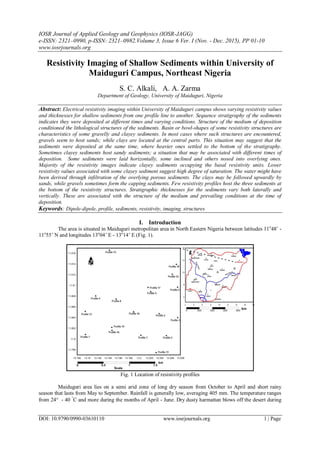
  • 1. IOSR Journal of Applied Geology and Geophysics (IOSR-JAGG) e-ISSN: 2321–0990, p-ISSN: 2321–0982.Volume 3, Issue 6 Ver. I (Nov. - Dec. 2015), PP 01-10 www.iosrjournals.org DOI: 10.9790/0990-03610110 www.iosrjournals.org 1 | Page Resistivity Imaging of Shallow Sediments within University of Maiduguri Campus, Northeast Nigeria S. C. Alkali, A. A. Zarma Department of Geology, University of Maiduguri, Nigeria Abstract: Electrical resistivity imaging within University of Maiduguri campus shows varying resistivity values and thicknesses for shallow sediments from one profile line to another. Sequence stratigraphy of the sediments indicates they were deposited at different times and varying conditions. Structure of the medium of deposition conditioned the lithological structures of the sediments. Basin or bowl-shapes of some resistivity structures are characteristics of some gravelly and clayey sediments. In most cases where such structures are encountered, gravels seem to host sands; while clays are located at the central parts. This situation may suggest that the sediments were deposited at the same time, where heavier ones settled to the bottom of the stratigraphy. Sometimes clayey sediments host sandy sediments; a situation that may be associated with different times of deposition. Some sediments were laid horizontally, some inclined and others nosed into overlying ones. Majority of the resistivity images indicate clayey sediments occupying the basal resistivity units. Lower resistivity values associated with some clayey sediment suggest high degree of saturation. The water might have been derived through infiltration of the overlying porous sediments. The clays may be followed upwardly by sands, while gravels sometimes form the capping sediments. Few resistivity profiles host the three sediments at the bottom of the resistivity structures. Stratigraphic thicknesses for the sediments vary both laterally and vertically. These are associated with the structure of the medium and prevailing conditions at the time of deposition. Keywords: Dipole-dipole, profile, sediments, resistivity, imaging, structures I. Introduction The area is situated in Maiduguri metropolitan area in North Eastern Nigeria between latitudes 11o 48’ - 11o 55’ N and longitudes 13o 04’ E - 13o 14’ E (Fig. 1). Fig. 1 Location of resistivity profiles Maiduguri area lies on a semi arid zone of long dry season from October to April and short rainy season that lasts from May to September. Rainfall is generally low, averaging 405 mm. The temperature ranges from 24 - 40  C and more during the months of April - June. Dry dusty harmattan blows off the desert during
  • 2. Resistivity Imaging of Shallow Sediments within University of Maiduguri Campus, Northeast Nigeria DOI: 10.9790/0990-03610110 www.iosrjournals.org 2 | Page the months of December - February. Evaporation is about 1600 mm. Maximum precipitation is from 650 - 700 mm. Effective precipitation is appreciably preceded by high rate of evaporation. The University of Maiduguri Campus is situated on the Chad Basin sediments. The campus area is relatively flat, but slopes gently away from the Bama Ridge area in the south towards the north. The soil consists of clays, sands and gravels. Shallow subsurface sediments considered in the survey comprise the superficial sediments and drift deposited by the activities of surface water runoff and winds. These sediments post-date the well known stratigraphy of the Chad Formation which is of plio-pleistocene age. Recent sand dunes accumulated in the Chad Basin and several ancient dune systems may be observed. The present work is aimed at determining 2D resistivity structures of shallow sediments within the University of Maiduguri Campus using dipole dipole arrangement. II. Geology of the study area The area is underlain by sediments of the Chad Formation (Fig. 2). The Chad Formation overlies the Kerri Kerri Formation of Tertiary period and it is in turn overlain by recent alluvial deposits (Barber, 1965). These sediments were deposited during the end of the Cretaceous period and the beginning of the Tertiary period. The formation covers an area of about 23,000 km2 in parts of Bauchi, Borno, Jigawa, Kano and Yobe States in Nigeria. The sediments are poorly sorted and vary in grain size and colour; finer grains exhibit fluviatile depositional patterns. Fig. 2 Geological map of part of Borno State showing the study area Deposition of the Chad Formation commenced after the regression of the sea southwards at the end of Cretaceous time (Barber and Jones, 1960). Boreholes’ drilling in Maiduguri has revealed three distinct zones of sandy sediments separated by clay deposits. The sediments show both lateral and vertical heterogeneities. III. Materials and methods The survey was designed to image/map subsurface sediments from only a few metres in depth. ABEM Terrameter was used to acquire the data. The survey was conducted in the month of July when the rainy season has fully set in, which minimized the fatigue of wetting the electrodes. Eighteen profile lines spanning from 100 - 110 m, and covering almost the entire University Campus area were established. The lines were coordinated with Global Positioning System at the beginning of the traverses. The spacing between the current electrodes pair, C2-C1 given as “a” was the same as the distance between the potential electrodes pair P1-P2 (Fig. 3). The factor marked as “n” is the ratio of the distance between the C1 and P1 electrodes to the C2-C1 (or P1-P2) dipole length “a”. For this array, the “a” spacing was initially kept fixed at the smallest unit electrode spacing and the “n” factor was increased from 1 to 2 to 3 until up to about 6 in order to increase the depth of investigation (Loke, 2000).
  • 3. Resistivity Imaging of Shallow Sediments within University of Maiduguri Campus, Northeast Nigeria DOI: 10.9790/0990-03610110 www.iosrjournals.org 3 | Page Fig. 3 Arrangement of the electrodes To plot the data from a 2D imaging survey, the data was inverted using the pseudosection contouring method in a DIPPRO software environment. In this case, the horizontal location of the point was placed at the mid-point of the set of electrodes used to make the measurement. Vertical location of the plotting point was placed at a distance that was proportional to the separation between the electrodes. Results of inverted model resistivity distribution of pseudosection for Profile 2 is shown in Fig. 4 (a) Field data pseudosection (b) Theoretical data pseudosection (c) 2D resistivity structure Fig. 4: Field data pseudosection, theoretical data pseudosection and 2D resistivity structure for Profile 2 IV. Electrical resistivity tomography Resistivity surveys measure variations in the electrical resistivity of the ground, by applying small electric currents across arrays of ground electrodes. The measured resistivity is a bulk physical property of materials that describes how difficult it is to pass an electrical current through the material. During the resistivity survey, current was injected into the earth through current electrodes and the potential difference, or “apparent resistivity” was measured between potential electrodes. Apparent resistivity is the bulk average resistivity of all soils and rock influencing the flow of current (Powers et al, 1999). It is calculated by dividing the measured potential difference with the input current, and multiplying by a geometric factor related to the array used and electrode spacing. Resistivity imaging or electrical tomography technique combines resistivity sounding and profiling, incorporates the effects of lateral variations in resistivity on sounding, and produces a two-dimensional subsurface resistivity image. All geophysical inversion methods try to determine a model for the subsurface whose response agrees with the measured data subject to certain restrictions. The model parameters are the resistivity values, while the data is the measured apparent resistivity values. The mathematical link between the model parameters and the model response for the 2D resistivity models is provided by the finite-difference (Dey and Morrison, 1979) or finite-element methods (Silvester and Ferrari, 1996). In all optimization methods, an initial model is modified in an iterative manner so that the difference between the model response and the observed data values agree reasonably well. Unconsolidated sediments generally have lower resistivity values than sedimentary rocks. Clay materials, metallic oxides, and sulphide minerals are common sedimentary materials that carry significant electrical current through them. As such, the resistivity of most near surface sedimentary materials is primarily controlled by the quantity and chemistry of the pore fluids within the material (Kumar, 2012). Any particular material can have a broad range of resistivity responses that is dependent on the level of saturation, the concentration of ions, the presence of organic fluids, faulting, jointing, weathering, etc (Loke, 2004). Eighteen traverses of lengths between 100 and 110 m were used for the purpose of the research. Resistivity structures along the profiles are presented, described and discussed. Resistivity image of Fig. 5 consists of clay sediments at its base from position 60 – 90 m of the profile distance. The clay deposit occurs in crescent form where its upper boundary terminates at a depth of 5 m around profile position of 70 – 80 m. Some clay sediments of a similar shape are also observed between 20 – 40 m at a
  • 4. Resistivity Imaging of Shallow Sediments within University of Maiduguri Campus, Northeast Nigeria DOI: 10.9790/0990-03610110 www.iosrjournals.org 4 | Page depth of 5 m. The basal interval of 40 – 60 m that separates the clays contains sands which may be traced upwards to 20 m below the surface. The sands are overlain by gravels at this depth to the surface. Thickness for the gravel deposits is around 20 m. Surface deposits of the profile length consists basically of gravels; except along positions 20 – 30 m and 60 – 70 m where 5 m thick of sandy sediments occur. Fig. 5 Resistivity Structure of Profile 1 Fig. 6 shows clay sediments at the bottom of the resistivity structure around profile position of 60 - 80 m. The clays terminate at 10 m below the surface. Sandy sediments are disseminated around 0 - 30 m on the surface and around 60 – 70 m at 5 m below the surface. Each sandy unit has an estimated thickness of 5 m. The main composition of the resistivity structure consists of unconsolidated and consolidated gravels of relatively higher resistivity values. The gravels that are separated at depth by clays and sands are linked on the surface. Fig. 6 Resistivity Structure of Profile 2 The basal unit of Fig. 7 is partitioned into sands (0 - 50 m), gravels (50 – 80 m), clays (80 – 90 m) and sands (90 – 110 m) of the profile length. The upper boundaries of the sands and clays terminate at depths of 10 m and 5 m respectively. Surface expression of the profile consists almost entirely of gravels, except along the lateral distance of 100 – 110 m, where a deposit of sand is observed. Fig. 7 Resistivity Structure of Profile 3 Along lateral distance of 60 – 90 m in Fig. 8, the basal unit is composed of a clay lens whose upper part is observed at a depth of 10 m along lateral distance of 70 – 90 m. Also at the base of the geoelectric section are deposits of gravels and sands. The lateral distance from 0 – 50 m contains gravels which extend through the
  • 5. Resistivity Imaging of Shallow Sediments within University of Maiduguri Campus, Northeast Nigeria DOI: 10.9790/0990-03610110 www.iosrjournals.org 5 | Page profile thickness to the surface. The lateral distance from 50 – 60 m has sands whose upper boundary can be reached at a depth of 20 m. The top of a sandy deposit is also observed at a depth of 10 m along profile distance of 80 – 90 m. Gravels form the surface cover of the subsurface materials. Fig. 8 Resistivity Structure of Profile 4 In Fig. 9 the basal topography is constituted essentially of clayey sediments that extended to a depth of 5 m around 70 – 80 m profile distance. The general thickness for the clay deposit is 20 m. The clays are followed upwardly by sandy sediments whose lower boundary is observed at 10 m below the surface. Surface expression of the sands is seen around 50 - 90 m distance of the profile. The sands measure about 5 m thick. A greater proportion of gravelly materials occur on the surface. These are observed around lateral positions of 0 - 50 m and 80 – 110 m. Thickness of the gravels may exceed 10 m as indicated along the interval of 100 – 110 m. Fig. 9 Resistivity Structure of Profile 5 Along Fig. 10 clayey sediments form the basal stratigraphy of the profile. The upper part of the clays can be reached at 5 m below ground level. Sandy sediments rest upon clayey sediments around lateral distances of 20 – 30 m and 50 – 70 m. Gravelly sediments are observed around 0 – 50 m and 70 – 110 m where their surface expressions are interrupted by a sandy deposit. The 70 – 110 m section of the profile probably served as a basin where about 10 m thick of gravelly materials were deposited. Fig. 10 Resistivity Structure of Profile 6 Clayey sediments dominate the profile length of Fig. 11. They occupy the basal unit and extend to the surface around 40 – 80 m. Most of the clays are saturated with water as indicated by their low resistivity values.
  • 6. Resistivity Imaging of Shallow Sediments within University of Maiduguri Campus, Northeast Nigeria DOI: 10.9790/0990-03610110 www.iosrjournals.org 6 | Page Sandy sediments are exposed on the surface and are limited to 0 – 40 m of the profile distance. They attain maximum thickness of 10 m. Surface position from 90 – 110 m of the profile is constituted by gravelly sediments of about 10 m thick. Fig. 11 Resistivity Structure of Profile 7 The bottom of the resistivity structure of Fig. 12 consists of clayey and sandy sediments. The upper part of the clays appears at 5 m below the surface around 70 – 80 m distance. A bowl shape medium consisting of clayey deposits occurs on the surface to a depth of 20 m around 20 – 50 m separation. Sandy sediments are the main host of the clays. Apart from the 50 – 60 m distance at a depth of 10 m where gravels are observed, the major proportion of gravelly sediments are confined to the 90 – 110 end of the profile where they are exposed on the surface. The gravels have vertical thickness of 10 m. Fig. 12 Resistivity Structure of Profile 8 The profile of Fig. 13 portrays an image of a basin, where gravelly sediments occupy the bottom (not completely revealed) of the basin. The gravels outcropped on the surface at the edges of the basin. Sandy sediments are laid on the gravels and clayey sediments occupy the central part of the basin. Both sandy and clayey deposits outcropped on the surface. Wider electrode separation may give a clearer picture of the structure of the basin. Fig. 13 Resistivity Structure of Profile 9 Clayey sediments are the main constituents at the base of the electrical resistivity image of Fig. 14. The upper surface of the clays approaches the surface at depths of 5 m around 40 - 60 m and 70 – 80 m of the profile
  • 7. Resistivity Imaging of Shallow Sediments within University of Maiduguri Campus, Northeast Nigeria DOI: 10.9790/0990-03610110 www.iosrjournals.org 7 | Page distances. Sandy sediments assumed the wavy structure developed by the upper margin of the clays. The sandy materials outcropped on the surface around 0 – 50 m and 70 – 80 m. At some locations the sands attained thickness of 20 m. Gravelly sediments occur on the surface along lateral distances of 50 – 70 m and 80 – 110. Estimated thickness of about 10 m of the deposit occurs around 100 - 110 m distance of the profile. Fig. 14 Resistivity Structure of Profile 10 Resistivity tomography of Fig. 15 indicates the resistivity basement to consisting of sand, gravel and clayey sediments. Basal sandy sediments are located at lateral intervals of 40 – 50 m and 70 – 80 m. Their upper margins occur at depths of 20 m. Gravelly materials occur from 50 – 70 m and are inclined upwardly to the surface around 80 – 90 m. Clayey sediments are observed around 80 – 90 m and are inclined to a depth of 10 m. Clayey sediments also occupy the electrodes’ range of 20 - 50 m at a depth of 5 – 20 m. The clays also appear on the surface along 50 – 80 m and have thickness of 5 m. Sandy sediments are exposed on the surface along 0 – 50 m and 90 – 110 m of the profile distances. Thicknesses for the sand deposits are 5 m and 10 m respectively. Fig. 15 Resistivity Structure of Profile 11 Electrical resistivity image of Fig. 16 shows clayey sediments occupying the base of the profile. Low resistivity values of the deposit are indications that the zone consists of saturated clays with attainable thickness of about 20 m at some locations. Sandy sediments are exposed on the surface along lateral position of 30 – 80 m. The general thickness for the sand deposits is 10 m. The sands are flanked to the start (0 – 30 m) and to the end (80 – 110 m) of the profile by gravelly sediments. The thickness of the gravel deposit may exceed 20 m. Fig. 16 Resistivity Structure of Profile 12
  • 8. Resistivity Imaging of Shallow Sediments within University of Maiduguri Campus, Northeast Nigeria DOI: 10.9790/0990-03610110 www.iosrjournals.org 8 | Page Clayey sediments form a substantial proportion of the base of the resistivity structure of Fig. 17. The clays extend upwards from the base to 10 m below the surface. A minor deposit of sandy sediments grades into gravels in place. The sandy deposit is located at 30 – 40 m distance at varying depths. Along lateral distance of 50 – 60 m the sands outcropped on the surface. Vertical thicknesses for the sands at the two locations are 10 m each. A significant quantity of gravels is present in the profile structure. The deposits occur at the start and end of the profile. The 80 – 110 m side of the gravels has thickness of 20 m. Fig. 17 Resistivity Structure of Profile 13 Clayey sediments occupy a part of the base of Fig. 18. The upper surface of the sediments can be traced to 5 m below the surface along 0 – 80 m profile length. Vertical contact of clays to the start of the profile is defined by gravelly sediments which extend to the surface from 80 – 110 m of the profile length. Thickness of the deposit may exceed 10 m. Sandy sediments are disseminated within the resistivity structure. A five metres thick of a sandy deposit occurs around 20 – 30 m distance at a depth of 5 m. Similar deposits occur along 50 – 60 m and 90 – 100 m distances. The earlier sand deposit outcropped on the surface and the later is 10 below the surface. Each sandy deposit has thickness of 10 m. Fig. 18 Resistivity Structure of Profile 14 The basal unit of Fig. 19 is dominated by thick clayey sediments. The clays extend to the surface around lateral distance of 70 – 80 m. A basin structure consisting of relative higher resistivity values that outcropped on the surface around 20 – 60 m, represents that of clayey sand - an interface between the top clayey layer and the bottom sand horizon (Keller and Frischknecht, 1966; Ayolabi, 2013). Main thickness for the sediments is 5 m, although thickness of 10 m may be obtained along 40 – 50 m lateral distance where complete transition to sandy sediments occurs. Gravelly sediments are the chief constituents around 80 – 110 m of the profile distance. Thickness of each sediment may exceed 20 m.
  • 9. Resistivity Imaging of Shallow Sediments within University of Maiduguri Campus, Northeast Nigeria DOI: 10.9790/0990-03610110 www.iosrjournals.org 9 | Page Fig. 19 Resistivity Structure of Profile 15 Fig. 20 has a crescent shaped deposit of clayey sediments at its bottom that nosed upwards to 5 m below the surface around 60 – 90 m of the profile length. Isolated pockets of sandy sediments are observed around lateral distances of 30 – 40 m, 50 - 70 m and 90 – 100 m of the profile length. While the sandy deposits at the two ends occur at 10 m below the surface, the central deposit is exposed on the surface. Gravelly sediments occur along 0 – 50 m and 70 – 110 m distances. The two deposits are exposed on the surface and vertical thickness for each deposit may exceed 10 m. Fig. 20 Resistivity Structure of Profile 16 Fig. 21 consists basically of clayey materials at the bottom. The thickest part of the clays at lateral interval of 40 - 50 m may reach 25 m. The clayey sediments are followed upwardly by sandy sequence at a depth of 10 m around 50 – 90 m. Similar sediments with thickness of 5 m outcropped on the surface around 30 – 40 m. Gravelly sediments occupy considerable parts of the profile. They are observed on the surface along the entire profile length and possess maximum thickness of 20 m along 90 – 100 m. Fig. 21 Resistivity Structure of Profile 17 The entire basal unit of Fig. 22 is composed of clayey sediments that arched upwards and terminated at 5 m below the surface around 50 – 80 m lateral distance. Sandy sediments are exposed on the surface from the beginning of the profile to 80 m lateral distance. The sands show varying thicknesses from 5 – 30 m. The proportion of gravelly materials in the resistivity structure is low. The disseminated gravel pockets occur on the surface at distances of 30 – 40 m and 80 - 110 m. Observed thicknesses for the gravel deposits are 5 m each, although towards the end of the profile, it may exceed 15 m.
  • 10. Resistivity Imaging of Shallow Sediments within University of Maiduguri Campus, Northeast Nigeria DOI: 10.9790/0990-03610110 www.iosrjournals.org 10 | Page Fig. 22 Resistivity Structure of Profile 18 V. Discussion and conclusion The basal units of most survey lines are characterized by clay sediments deposited under low current velocity. Some of the clays at the bottom of the resistivity structures are saturated as indicated by their low resistivity values. The porous overlying sediments might have aided infiltration of rainwater into the underlying clays. Basin structures are common among some profile lines. Some basins are hosts to gravelly sediments at the bottom, which is overlain by sandy sediments and clayey sediments at the central part. The sediments of such basin types were probably deposited by the same transporting agent. Clays, sands and gravels are common sediments occurring at the base of some profile lines. Basin structures of sandy sediments harbour clayey sediments and vice-versa within their depressed regions. The crescent structure of clay sediments at the bottom of a resistivity structure arched upwards into overlying sediments. Pockets of sandy sediments are common within some profiles. Deposition of sandy sediments inherited the sinusoidal structures developed by the upper margins of the clays in some areas. Interfaces between the top sandy layer and the bottom gravelly horizon graded into gravels in places. Some resistivity structures accommodated unconsolidated and consolidated gravels. Gravelly materials form the main surface cover of most subsurface sediments. In places gravelly and clayey sediments are inclined upwardly towards the surface, which is attributed to the nature of the medium to which the sediments settled. The general composition for the sediments shows varying depositional patterns. The erratic grading of the sediments in the area may suggest that surface water runoff and winds were probably the main transporting agents. References [1]. Ayolabi, .E. A., Folorunso, A. F. and Idem, S. S., (2013): Application of Electrical Resistivity Tomography in Mapping Subsurface Hydrocarbon Contamination. Earth Science Research, Vol. 2(1), pp 93- 104. [2]. Barber, W. and Jones, D. G., (1960): The Geology and Hydrogeology of Maiduguri. Geological Survey of Nigeria Records, 20 p. [3]. Barber, W., (1965): Pressure Water in the Chad Formation of Borno and Dikwa Emirates, North East Nigeria. Geological Survey of Nigeria, Bulletin 35, 138 p. [4]. Dey, A. and Morrison H. F., (1979): Resistivity Modelling for Arbitrarily Shaped Two – Dimensional Structures, Vol. 27(1), pp 106 –136. [5]. Keller, G. V. and Frischknecht, F. C., (1966): Electrical Methods in Geophysical Prospecting. Oxford: Pergamon Press Inc. [6]. Kumar, D., (2012): Efficacy of Electrical Resistivity Tomography Technique in Mapping Shallow Subsurface Anomaly. Journal Geological Society of India, Vol. 80 pp 304 - 307 [7]. Loke, M. H., (2000): Electrical Imaging Surveys for Environmental and Engineering Studies: A Practical Guide for 2D and 3D Surveys. Retrieved from www.terrajp.co.Jp/lokenote.pdf. [8]. Loke, M. H., (2004): Tutorial: 2-D and 3-D Electrical Imaging Surveys. 2004 Revised Edition. Retrieved from www.geoelectrical.com. [9]. Powers, C. J., Wilson, J., Haeni, F. P. and Johnson, C. D., (1999): Surface-Geophysical Characterization of the University of Connecticut Landfill, Storrs, Connecticut: U.S. Geological Survey Water Resources Investigations Report 99-4211. [10]. Silvester, P. P. and Ferrari. R. L., (1996): Finite Elements for Electrical Engineers. Cambridge University Press.