SlideShare a Scribd company logo
1 of 4
Download to read offline
Agus Santoso et al. Int. Journal of Engineering Research and Application www.ijera.com
ISSN : 2248-9622, Vol. 6, Issue 9, ( Part -4) September 2016, pp.01-04
www.ijera.com 1|P a g e
Subsurface Determination Of Cavities In Limestone Rock Area
By Geoelectric Method In Tinapan Village Todanan Blora
District Central Java Indonesia
Agus Santoso1,2
, Sismanto3
, Ari Setiawan4
, Subagyo Pramumijoyo5
Indriati Retno Palupi2
1
Ph.D. Student, Physics Department, GadjahMada University, Indonesia
2
Geophysical Engineering, UPN "Veteran" University, Yogyakarta, Indonesia
3
Physics Department, FMIPA GadjahMada University, Indonesia
4
Physics Department, FMIPA GadjahMada University, Indonesia Geology engineering GadjahMada
University, Indonesia
Corresponding author: agussantoso1953@gmail.com
ABSTRACT
Two Dimensional of geoelectric method can be used to find out the conductive formation in the earth surface.
The purpose of this research is to give the description about the geological subsurface formation, that the high
resistivity value is indicate the potential area of cave and void in the limestone rocks.
The dipole dipolegeoelectric method is used in this research with the path of lines is 250 m with 10 m electrode
spacing. The total lines is 7 and the azimuth is from east to west. Resistivity method is started with inject the
electrical current into the earth by current electrode, then potential difference will arise and measured by
potential electrode. Variation value of resistance for each layer rock can calculated by divided potential
defference with current value.
The existence of the cavity is known by the resistivity value is more than 2500 ohm-m, while the cracks have a
resistivity of 1500 to 2500 ohm-m.
Keywords: Geoelectric, resistivity, dipole-dipole, ohm-m, Cavities.
I. INTRODUCTION
Geoelectric method is a geophysical method
that learn about the flow of electricity in the
subsurface and detect it in the surface of the earth.
In this method there are several parameters needed,
they are potential measurements, currents and
electromagnetic fields. There are many kinds of
geoelectricmethod, they are self potential, telluric
current, magneto-teluric, electromagnetic, induced
polarization and resistivity.
In resistivity method, the current is injected
into subsurface by the current electrode, then
potential difference will arise and measured by
potential electrode. The variation of spacing of the
electrode can reduce the variation value of
resistivity in each type of barrier layer below the
measuring point.
II. BASIC THEORY
The basic principle of geoelectric method is
Ohm’s Law, where the resistance is obtained by
measuring the potential difference and current in
the subsurface :
(1)
where R is the resistance (Ω), V is potential
difference (Volt) and I is current (Ampere).
Because the medium in the subsurface is very
heterogeneous, so there are variety in the resistance
value. It can be measured by configuration factor
(K) in addition to read potential and current value.
R (2)
where is apparent resistivity. The implementation
of resistivity method is inject the current into
subsurface to potential electrode. The space of
current and potential electrode is varied to get the
resistivity value at any distance between them. By
plotting resistivity versus electrode space, it can
obtained the curve that describe functional
relationship.
 V I
P 1 P 2 O C 1 C 2
a n a a
V
V
Figure 1.Geoelectric dipole-dipole arrangement
C1P1 = a+na = a(n+1) ; C1P2 = na
C2P1 = a+na+a = a(n+2)
C2P2 = na+a = a(n+1)
RESEARCH ARTICLE OPEN ACCESS
Agus Santoso et al. Int. Journal of Engineering Research and Application www.ijera.com
ISSN : 2248-9622, Vol. 6, Issue 9, ( Part -4) September 2016, pp.01-04
www.ijera.com 2|P a g e
1
d
)1n(a
1
na
1
)2n(a
1
)1n(a
1
2k













1
d
na
1
)2n(a
1
)1n(a
2
2k












1
d
)2n)(1n)(n(a
)2n)(1n()1n)(n()2n)(n(2
2k










)2n)(1n)(n(ak d
 (3)
and apparent resistivity is :
I
V
)2n)(1n)(n(a

 (4)
Geoelectric equipment
The equipment used in this research are :
1. ARESdigitalresistivity meter
2. Cable 4rollswith a length ofover 300m
3. Twocurrentelectrodesand2(two)
potentialelectrode
4. 12 voltbatteriesandsomedry batterytype
5. GPS(Global PositioningSystem)
6. Compassgeologyandgeologicalhammer
7. Distance measuring tool andmultimeter
8. Topographic mapsscale 1: 5000.
III. DATA ACQUISITION
Dipole-dipole method is used to measure the
rock resistivity. Principally, injecting electrical
current into subsurface it will be obtained the
potential difference in the medium that contains
information about rock resistivity. Current usedis
preferably direct current, but to avoid the influence
of the capacitance and the polarization (the
tendency of rock store charge) thenusedan
alternating currentof low frequency.This
currentflowsinto subsurface throughtwo
electrodescalled thecontactelectrodecurrent,then
resultingpotential distributionthrough thepotential
electrode. By knowing the current flow that caused
the great potential, it can be calculated the rock
resistant in the subsurface, the distance of each
current and potential electrode. Figure 1 describe
about the configuration of current (C1 and C2) and
potential (P1 and P2) electrode.
Tabel. Coordinates from : line 01 - 07
LINE Azimut
h
COORDINATES
(UTM)
Starting
Point
Endpoint
Line-
01
N 90O
E x :
0522342
y :
9227950
x :
0522590
y :
9227950
Line- N 90O
E x : x :
02 0522338
y :
9227856
0522590
y :
9227853
Line-
03
N 90O
E x :
0522259
y :
9227775
x :
0522495
y :
9227772
Line-
04
N 90O
E x :
0522243
y :
9227714
x :
0522481
y :
9227714
Line-
05
N 0O
E x :
0522607
y :
9227969
x :
0522607
y :
9227727
Line-
06
N 90O
E x :
0522342
y :
9227889
x :
0522590
y :
9227885
Line-
07
N 90O
E x :
0522371
y :
9227820
x :
0522624
y :
9227821
IV. GENERAL GEOLOGY
1. Geomorphology
The geomorphology of the research area is include
to the Rembang-Madura antiklinorium. This area
can be divided into two kinds of morphological
units, the first isdenudasional sloping hills and the
second is steep hills structural units of anticline. In
general, the research area is located in the hills with
lush vegetation and the relief is not so high. The
topography of this area is caused by the presence of
either clastic limestone or limestone reef (reef) that
located in thetop of the Bulu Formation. This area
is a karst topography, there are many rivers and
underground cavities in limestone reef.
2. Lithology (rock composition)
Based on it’s regional stratigraphic, it is include
four kinds of rock units, from the oldest to the
youngest, the massive limestone unit, quartz
sandstone unit, unit of organic lime stones and
sandy limestones with sandstones glauconit inserts.
From the regional of geology, the structure found
in the area arelimestone stocky, regional fault
structure that crosses the village Tinapan.Historical
geological mapping of the area began in the Middle
Miocene and Late Miocene ended, beginning with
the deposition of limestone (Tawun Formation),
followed by precipitation of quartz sandstone
(Ngrayong Formation), organic lime stones (Bulu
Formation), last sandy lime stones (Ledok
Formation). While geological disasters that can
happen is a mass movement in the form of creep
and avalanches result from mining.
Agus Santoso et al. Int. Journal of Engineering Research and Application www.ijera.com
ISSN : 2248-9622, Vol. 6, Issue 9, ( Part -4) September 2016, pp.01-04
www.ijera.com 3|P a g e
Lithology or rock-forming region is a limestone
reef formations that are widespread throughout the
Bulu Formation in Blora that located at the top of
Pati carbonate composition, both clastic and non-
clastic, the clastic rocks are well layered, with a
thickness of 2 cm - 50 cm whereas a non clastic
reef (coral reefs) with a circular shape - the
circumference to form a morphological karst
topography.The shape of this reef rock often
forming cavity - small to large cavities that occur
due to the leaching process due to groundwater or
rainwater, these rocks have vug porosity, so the
porosity is large enough. Besides this karst area
formed the river - underground river which flows
from north to south through the dams (small dams)
were watery during the year.
V. DATA PROCESSING AND
ANALYSIS
Based on the final result of this research that
proseccing with Res2dinv software, it can be
analized that the depth resistivitycorrelate with
themagnitude ofthe real("True resistivity") of
therockis dividedinto a number ofrock unitsas
follows:
1.The cover layer(Soil).
Resistivityranging from 50 tomorethan 1000Ω
meters, consisting ofloose sand, marl, silt,
gravelandgravel.
2.UnitClay/Marl
Resistivityless than 10Ω meters,consisting ofmarl.
Generally permeable
3.CalcareousSandUnit
Resistivity value is ranging from 10 to 100Ω
meters,
whichcomprisescalcareoussandstonelimestoneclasti
csedimentsis generally aresultof eruption
ofvolcanoes. Is agoodaquifer, highly permeable,
andcontainsplenty ofwaterdischarge.
4.SandyLimestoneunit.
Resistivity value is ranging from 100 to 200Ω
meters, consisting ofa mixture
oflimestonewithorfine sandsizeupa bit rude.
5.LimestoneUnit
Resistivity value is ranging from200 to 500Ω
meter, limestone with fragments
oflimestonebouldersthe size of5-10 mm, matrixof
sandandcarbonatecement.
6.Limestonecompactunit
Resistivity value is ranging from 500 to 1500Ω
meters. Very compactsometimes withfragments
oflimestoneboulders5-10 cm,
matrixcalcareoussands, carbonatecement.
7. Cracks in limestone that have resistivity value
that ranging grom 1500 to 2500 Ω meters
8. Cavitiesinlimestone.
Resisitivity value is larger than 2500 Ω meter, the
greaterthevalueresistivitybethe greater
thecavitiesinthe rock.
Figure 2. Line 01
Description: Line 01
There is no limestone cavities in rocks, here there
are only rocks cracked, form a small cavity
diameter less than 5 cm. Cracks located at 85-95 m,
130-135 m and 160-165 m.
Figure 3. Line 02
Description: Line 02
There is nolimestonecavitiesin rocks,herethere are
onlyrocks crackedat50-60m, at the depth of3-
16mand80-195mat the depth more than30 m.
cracksformsmallcavitieswithdiameterless than 5cm.
Figure 4. Line 03
Description: Line 03
Cavity (> 2500 Ω meters) is located on 55-60 m,
82-85 m, 103-112 m and 125-128 m in diameter 3-
10 m,at the depth of 2-6 m. At the bottom there are
cavities in the limestone surrounded by sandy Bulu
Formation limestone, forming limestone reefs.
Figure 5. Line 04
Agus Santoso et al. Int. Journal of Engineering Research and Application www.ijera.com
ISSN : 2248-9622, Vol. 6, Issue 9, ( Part -4) September 2016, pp.01-04
www.ijera.com 4|P a g e
Description: Line 04
Cavity (> 2500 ohm-m) is located on 95-105 m
with the depth of 15 m until more than 31 m. found
on the surface152-154 m, at a depth of 1.5 - 4 m.At
the bottom there are cavities in the limestone
surrounded by sandy Limestone.
Figure 6. Line 05
Description: Line 05
There is nolimestonecavitiesin rocks,there are
onlyrocks crackedforma
smallcavitydiameterlessthan 6cm. at65-70mat the
depth of9 mto 25m. On the surface.these
cracksfound in55-57m, 67-74m, 81-83m, (at 155-
167mdepth12m) and227-233mwith a depthup to
5m.
Figure 7. Line 06
Description: Line 06
There is nolimestonecavitiesin rocks,there are
onlyrocks cracked forma
smallcavitydiameterlessthan5 cm. crackslocated
at86-92m, at the depthsmore than 8 m. this area
isstable enoughbecause theyonly
slightcrackswithoutcavity.
Figure 8. Line 07
Description: 07
Cavity (> 2500 Ω meters) arequite largeat97-
150mwith the depth of29 muntil more than34 m.
The top of cavity is found in142-145m, at a depth
of5-7m and the bottom ofare includedrock
sedimentarysandstone orclayofTawun Formation
Fig 9. Location Map ofcavitiesandcracks
VI. CONCLUSION
Interpretation of cavity
Line - 01: There is no existing cavity is formed
crack rock crevices with a small hole diameter
2-5 cm. Cracks found in 85-95 m, 130-135 m
and 160-165 m to more than 30 m.
Line - 02:. Cracks found on the meters to 50-60 m
at the depth of 3-16 m, and, on the surface of
the meter to 80-195 m, at a depth that more
than 30 m. Basically rock strong enough.
Line - 03: no cavities - cavities in four places on
the meters to 55-60 m, 82-85 m, 103-112 m,
and 125-128 m, a depth of 2-6 m, to form
limestone reefs / coral reefs.
Line - 04: no cavities in two places on the 95-105
m, which is enough to more than 30 m
somewhat enlarged. On the surface there is a
small cavity at 152-154 m with a depth of 2-4
m
Line - 05:. No existing cavity is formed cracks
rock crevices with a small hole diameter 2-5
cm. the meters to 65-70 m at a depth of 9 m
and, on the surface at the meters to 57-67 m, at
a depth of 5 m. There are also cracks in the
155-165 m at the depth of 15 m.
Line - 06: forming little cracks with small hole
diameter 2-5 cm. the meters to 86-92 m at
depths more than 8 m and, basically strong and
stable rock, the rock is not hollow and little
cracks only.
Line - 07:. There cavity - the cavity in two places
at meters to 97-150 m, which is quite large and
in up to more than 30 m somewhat enlarged.
On the surface there is a small cavity at 142-
145 m with a depth of 5-7 m. In this trajectory
limestone reefs in the middle of the track are
covered by limestone lined the edge of a path.

More Related Content

What's hot

F021203036039
F021203036039F021203036039
F021203036039theijes
 
Site Investigation of Subsurface Lithology of Ignatius Ajuru University of Ed...
Site Investigation of Subsurface Lithology of Ignatius Ajuru University of Ed...Site Investigation of Subsurface Lithology of Ignatius Ajuru University of Ed...
Site Investigation of Subsurface Lithology of Ignatius Ajuru University of Ed...Associate Professor in VSB Coimbatore
 
2020-02-12 Theory of Application of Synthetic Aperture Radar
2020-02-12 Theory of Application of Synthetic Aperture Radar2020-02-12 Theory of Application of Synthetic Aperture Radar
2020-02-12 Theory of Application of Synthetic Aperture RadarYosuke Aoki
 
Geophysics
GeophysicsGeophysics
Geophysicsfulay
 
Geoelectrical assessment of a proposed dam site around ehuhe area of oji rive...
Geoelectrical assessment of a proposed dam site around ehuhe area of oji rive...Geoelectrical assessment of a proposed dam site around ehuhe area of oji rive...
Geoelectrical assessment of a proposed dam site around ehuhe area of oji rive...Alexander Decker
 
Evaluation of Heterogeneous Aquifers in Crystalline Rocks from Resistivity So...
Evaluation of Heterogeneous Aquifers in Crystalline Rocks from Resistivity So...Evaluation of Heterogeneous Aquifers in Crystalline Rocks from Resistivity So...
Evaluation of Heterogeneous Aquifers in Crystalline Rocks from Resistivity So...theijes
 
Role of Geophysics in the Oil and Gas Industry
Role of Geophysics in the Oil and Gas IndustryRole of Geophysics in the Oil and Gas Industry
Role of Geophysics in the Oil and Gas IndustryMusisi Norbert
 
Determination of Thickness of Aquifer with Vertical Electrical Sounding
Determination of Thickness of Aquifer with Vertical Electrical Sounding Determination of Thickness of Aquifer with Vertical Electrical Sounding
Determination of Thickness of Aquifer with Vertical Electrical Sounding iosrjce
 
Geophysical investigation
Geophysical investigation Geophysical investigation
Geophysical investigation shruthiv19
 
Ground water Survey and Water Quality
Ground water Survey and Water QualityGround water Survey and Water Quality
Ground water Survey and Water Qualitykeyur pansara
 
Resistivity Imaging of Shallow Sediments within University of Maiduguri Campu...
Resistivity Imaging of Shallow Sediments within University of Maiduguri Campu...Resistivity Imaging of Shallow Sediments within University of Maiduguri Campu...
Resistivity Imaging of Shallow Sediments within University of Maiduguri Campu...iosrjce
 
Geophysical investigation into the cause(s) of structural failure within baco...
Geophysical investigation into the cause(s) of structural failure within baco...Geophysical investigation into the cause(s) of structural failure within baco...
Geophysical investigation into the cause(s) of structural failure within baco...Alexander Decker
 
Subsurface 2D Image Analyses of the Uyangha Basement Area, South-Eastern Nigeria
Subsurface 2D Image Analyses of the Uyangha Basement Area, South-Eastern NigeriaSubsurface 2D Image Analyses of the Uyangha Basement Area, South-Eastern Nigeria
Subsurface 2D Image Analyses of the Uyangha Basement Area, South-Eastern NigeriaIOSR Journals
 
Seismic Refraction Survey for Groundwater Potentials of Northern Paiko Area. ...
Seismic Refraction Survey for Groundwater Potentials of Northern Paiko Area. ...Seismic Refraction Survey for Groundwater Potentials of Northern Paiko Area. ...
Seismic Refraction Survey for Groundwater Potentials of Northern Paiko Area. ...iosrjce
 
Geo Environmental Investigation of Abuad Dumpsite, Southwestern Nigeria
Geo Environmental Investigation of Abuad Dumpsite, Southwestern NigeriaGeo Environmental Investigation of Abuad Dumpsite, Southwestern Nigeria
Geo Environmental Investigation of Abuad Dumpsite, Southwestern NigeriaIJERA Editor
 

What's hot (19)

F021203036039
F021203036039F021203036039
F021203036039
 
Site Investigation of Subsurface Lithology of Ignatius Ajuru University of Ed...
Site Investigation of Subsurface Lithology of Ignatius Ajuru University of Ed...Site Investigation of Subsurface Lithology of Ignatius Ajuru University of Ed...
Site Investigation of Subsurface Lithology of Ignatius Ajuru University of Ed...
 
2020-02-12 Theory of Application of Synthetic Aperture Radar
2020-02-12 Theory of Application of Synthetic Aperture Radar2020-02-12 Theory of Application of Synthetic Aperture Radar
2020-02-12 Theory of Application of Synthetic Aperture Radar
 
Presentation on geophysical methods
Presentation on geophysical methodsPresentation on geophysical methods
Presentation on geophysical methods
 
Geophysics
GeophysicsGeophysics
Geophysics
 
Geoelectrical assessment of a proposed dam site around ehuhe area of oji rive...
Geoelectrical assessment of a proposed dam site around ehuhe area of oji rive...Geoelectrical assessment of a proposed dam site around ehuhe area of oji rive...
Geoelectrical assessment of a proposed dam site around ehuhe area of oji rive...
 
Evaluation of Heterogeneous Aquifers in Crystalline Rocks from Resistivity So...
Evaluation of Heterogeneous Aquifers in Crystalline Rocks from Resistivity So...Evaluation of Heterogeneous Aquifers in Crystalline Rocks from Resistivity So...
Evaluation of Heterogeneous Aquifers in Crystalline Rocks from Resistivity So...
 
Role of Geophysics in the Oil and Gas Industry
Role of Geophysics in the Oil and Gas IndustryRole of Geophysics in the Oil and Gas Industry
Role of Geophysics in the Oil and Gas Industry
 
Determination of Thickness of Aquifer with Vertical Electrical Sounding
Determination of Thickness of Aquifer with Vertical Electrical Sounding Determination of Thickness of Aquifer with Vertical Electrical Sounding
Determination of Thickness of Aquifer with Vertical Electrical Sounding
 
Geophysical investigation
Geophysical investigation Geophysical investigation
Geophysical investigation
 
C251221
C251221C251221
C251221
 
Ground water Survey and Water Quality
Ground water Survey and Water QualityGround water Survey and Water Quality
Ground water Survey and Water Quality
 
Resistivity Imaging of Shallow Sediments within University of Maiduguri Campu...
Resistivity Imaging of Shallow Sediments within University of Maiduguri Campu...Resistivity Imaging of Shallow Sediments within University of Maiduguri Campu...
Resistivity Imaging of Shallow Sediments within University of Maiduguri Campu...
 
E262634
E262634E262634
E262634
 
Geophysical investigation into the cause(s) of structural failure within baco...
Geophysical investigation into the cause(s) of structural failure within baco...Geophysical investigation into the cause(s) of structural failure within baco...
Geophysical investigation into the cause(s) of structural failure within baco...
 
Subsurface 2D Image Analyses of the Uyangha Basement Area, South-Eastern Nigeria
Subsurface 2D Image Analyses of the Uyangha Basement Area, South-Eastern NigeriaSubsurface 2D Image Analyses of the Uyangha Basement Area, South-Eastern Nigeria
Subsurface 2D Image Analyses of the Uyangha Basement Area, South-Eastern Nigeria
 
Gi2511541161
Gi2511541161Gi2511541161
Gi2511541161
 
Seismic Refraction Survey for Groundwater Potentials of Northern Paiko Area. ...
Seismic Refraction Survey for Groundwater Potentials of Northern Paiko Area. ...Seismic Refraction Survey for Groundwater Potentials of Northern Paiko Area. ...
Seismic Refraction Survey for Groundwater Potentials of Northern Paiko Area. ...
 
Geo Environmental Investigation of Abuad Dumpsite, Southwestern Nigeria
Geo Environmental Investigation of Abuad Dumpsite, Southwestern NigeriaGeo Environmental Investigation of Abuad Dumpsite, Southwestern Nigeria
Geo Environmental Investigation of Abuad Dumpsite, Southwestern Nigeria
 

Viewers also liked

Efficient Planning Scheduling and Delay Analysis of Residential Project
Efficient Planning Scheduling and Delay Analysis of Residential ProjectEfficient Planning Scheduling and Delay Analysis of Residential Project
Efficient Planning Scheduling and Delay Analysis of Residential ProjectIJERA Editor
 
Chosen Problems in Agro Logistics - a Proposals to the Use of Selected Indica...
Chosen Problems in Agro Logistics - a Proposals to the Use of Selected Indica...Chosen Problems in Agro Logistics - a Proposals to the Use of Selected Indica...
Chosen Problems in Agro Logistics - a Proposals to the Use of Selected Indica...IJERA Editor
 
Total Ozone Content over Kathmandu from TOMS Observations
Total Ozone Content over Kathmandu from TOMS ObservationsTotal Ozone Content over Kathmandu from TOMS Observations
Total Ozone Content over Kathmandu from TOMS ObservationsIJERA Editor
 
FPGA based JPEG Encoder
FPGA based JPEG EncoderFPGA based JPEG Encoder
FPGA based JPEG EncoderIJERA Editor
 
The State of Analytical Instruments in Some Environmental Pollution Control L...
The State of Analytical Instruments in Some Environmental Pollution Control L...The State of Analytical Instruments in Some Environmental Pollution Control L...
The State of Analytical Instruments in Some Environmental Pollution Control L...IJERA Editor
 
The Use Of Permeable Concrete For Ground Water Recharge
The Use Of Permeable Concrete For Ground Water RechargeThe Use Of Permeable Concrete For Ground Water Recharge
The Use Of Permeable Concrete For Ground Water RechargeIJERA Editor
 
Effect of Weaknesses of the Internal Control Systems And NonCompliance With S...
Effect of Weaknesses of the Internal Control Systems And NonCompliance With S...Effect of Weaknesses of the Internal Control Systems And NonCompliance With S...
Effect of Weaknesses of the Internal Control Systems And NonCompliance With S...IJERA Editor
 
Dielectric properties of Ni-Al nano ferrites synthesized by citrate gel method
Dielectric properties of Ni-Al nano ferrites synthesized by citrate gel methodDielectric properties of Ni-Al nano ferrites synthesized by citrate gel method
Dielectric properties of Ni-Al nano ferrites synthesized by citrate gel methodIJERA Editor
 
Optimization of Process Parameters And Dielectric Fluids on Machining En 31 B...
Optimization of Process Parameters And Dielectric Fluids on Machining En 31 B...Optimization of Process Parameters And Dielectric Fluids on Machining En 31 B...
Optimization of Process Parameters And Dielectric Fluids on Machining En 31 B...IJERA Editor
 
An Effective Security Mechanism for M-Commerce Applications Exploiting Ontolo...
An Effective Security Mechanism for M-Commerce Applications Exploiting Ontolo...An Effective Security Mechanism for M-Commerce Applications Exploiting Ontolo...
An Effective Security Mechanism for M-Commerce Applications Exploiting Ontolo...IJERA Editor
 
Selection of Supplier by Using Saw and Vikor Methods
Selection of Supplier by Using Saw and Vikor MethodsSelection of Supplier by Using Saw and Vikor Methods
Selection of Supplier by Using Saw and Vikor MethodsIJERA Editor
 
Life Cycle Energy Analysis of a Traditional Building in India (A Case Study)
Life Cycle Energy Analysis of a Traditional Building in India (A Case Study)Life Cycle Energy Analysis of a Traditional Building in India (A Case Study)
Life Cycle Energy Analysis of a Traditional Building in India (A Case Study)IJERA Editor
 
Monitoring Of Water Logged Areas in Krishana Canal Command Using Gis Techniques
Monitoring Of Water Logged Areas in Krishana Canal Command Using Gis TechniquesMonitoring Of Water Logged Areas in Krishana Canal Command Using Gis Techniques
Monitoring Of Water Logged Areas in Krishana Canal Command Using Gis TechniquesIJERA Editor
 
Cyclic Response of Reinforced Concrete Moment Resisting Beams Repaired with E...
Cyclic Response of Reinforced Concrete Moment Resisting Beams Repaired with E...Cyclic Response of Reinforced Concrete Moment Resisting Beams Repaired with E...
Cyclic Response of Reinforced Concrete Moment Resisting Beams Repaired with E...IJERA Editor
 
Research On Preserving User Confidentiality In Cloud Computing – Design Of A ...
Research On Preserving User Confidentiality In Cloud Computing – Design Of A ...Research On Preserving User Confidentiality In Cloud Computing – Design Of A ...
Research On Preserving User Confidentiality In Cloud Computing – Design Of A ...IJERA Editor
 
Production of Xylose from Corncobs
Production of Xylose from Corncobs Production of Xylose from Corncobs
Production of Xylose from Corncobs IJERA Editor
 
Applications and Properties of Unique Coloring of Graphs
Applications and Properties of Unique Coloring of GraphsApplications and Properties of Unique Coloring of Graphs
Applications and Properties of Unique Coloring of GraphsIJERA Editor
 
Performance Improvement Of Bengali Text Compression Using Transliteration And...
Performance Improvement Of Bengali Text Compression Using Transliteration And...Performance Improvement Of Bengali Text Compression Using Transliteration And...
Performance Improvement Of Bengali Text Compression Using Transliteration And...IJERA Editor
 
Grid Integration of Large PV Power Systems Using HVDC Link
Grid Integration of Large PV Power Systems Using HVDC LinkGrid Integration of Large PV Power Systems Using HVDC Link
Grid Integration of Large PV Power Systems Using HVDC LinkIJERA Editor
 

Viewers also liked (19)

Efficient Planning Scheduling and Delay Analysis of Residential Project
Efficient Planning Scheduling and Delay Analysis of Residential ProjectEfficient Planning Scheduling and Delay Analysis of Residential Project
Efficient Planning Scheduling and Delay Analysis of Residential Project
 
Chosen Problems in Agro Logistics - a Proposals to the Use of Selected Indica...
Chosen Problems in Agro Logistics - a Proposals to the Use of Selected Indica...Chosen Problems in Agro Logistics - a Proposals to the Use of Selected Indica...
Chosen Problems in Agro Logistics - a Proposals to the Use of Selected Indica...
 
Total Ozone Content over Kathmandu from TOMS Observations
Total Ozone Content over Kathmandu from TOMS ObservationsTotal Ozone Content over Kathmandu from TOMS Observations
Total Ozone Content over Kathmandu from TOMS Observations
 
FPGA based JPEG Encoder
FPGA based JPEG EncoderFPGA based JPEG Encoder
FPGA based JPEG Encoder
 
The State of Analytical Instruments in Some Environmental Pollution Control L...
The State of Analytical Instruments in Some Environmental Pollution Control L...The State of Analytical Instruments in Some Environmental Pollution Control L...
The State of Analytical Instruments in Some Environmental Pollution Control L...
 
The Use Of Permeable Concrete For Ground Water Recharge
The Use Of Permeable Concrete For Ground Water RechargeThe Use Of Permeable Concrete For Ground Water Recharge
The Use Of Permeable Concrete For Ground Water Recharge
 
Effect of Weaknesses of the Internal Control Systems And NonCompliance With S...
Effect of Weaknesses of the Internal Control Systems And NonCompliance With S...Effect of Weaknesses of the Internal Control Systems And NonCompliance With S...
Effect of Weaknesses of the Internal Control Systems And NonCompliance With S...
 
Dielectric properties of Ni-Al nano ferrites synthesized by citrate gel method
Dielectric properties of Ni-Al nano ferrites synthesized by citrate gel methodDielectric properties of Ni-Al nano ferrites synthesized by citrate gel method
Dielectric properties of Ni-Al nano ferrites synthesized by citrate gel method
 
Optimization of Process Parameters And Dielectric Fluids on Machining En 31 B...
Optimization of Process Parameters And Dielectric Fluids on Machining En 31 B...Optimization of Process Parameters And Dielectric Fluids on Machining En 31 B...
Optimization of Process Parameters And Dielectric Fluids on Machining En 31 B...
 
An Effective Security Mechanism for M-Commerce Applications Exploiting Ontolo...
An Effective Security Mechanism for M-Commerce Applications Exploiting Ontolo...An Effective Security Mechanism for M-Commerce Applications Exploiting Ontolo...
An Effective Security Mechanism for M-Commerce Applications Exploiting Ontolo...
 
Selection of Supplier by Using Saw and Vikor Methods
Selection of Supplier by Using Saw and Vikor MethodsSelection of Supplier by Using Saw and Vikor Methods
Selection of Supplier by Using Saw and Vikor Methods
 
Life Cycle Energy Analysis of a Traditional Building in India (A Case Study)
Life Cycle Energy Analysis of a Traditional Building in India (A Case Study)Life Cycle Energy Analysis of a Traditional Building in India (A Case Study)
Life Cycle Energy Analysis of a Traditional Building in India (A Case Study)
 
Monitoring Of Water Logged Areas in Krishana Canal Command Using Gis Techniques
Monitoring Of Water Logged Areas in Krishana Canal Command Using Gis TechniquesMonitoring Of Water Logged Areas in Krishana Canal Command Using Gis Techniques
Monitoring Of Water Logged Areas in Krishana Canal Command Using Gis Techniques
 
Cyclic Response of Reinforced Concrete Moment Resisting Beams Repaired with E...
Cyclic Response of Reinforced Concrete Moment Resisting Beams Repaired with E...Cyclic Response of Reinforced Concrete Moment Resisting Beams Repaired with E...
Cyclic Response of Reinforced Concrete Moment Resisting Beams Repaired with E...
 
Research On Preserving User Confidentiality In Cloud Computing – Design Of A ...
Research On Preserving User Confidentiality In Cloud Computing – Design Of A ...Research On Preserving User Confidentiality In Cloud Computing – Design Of A ...
Research On Preserving User Confidentiality In Cloud Computing – Design Of A ...
 
Production of Xylose from Corncobs
Production of Xylose from Corncobs Production of Xylose from Corncobs
Production of Xylose from Corncobs
 
Applications and Properties of Unique Coloring of Graphs
Applications and Properties of Unique Coloring of GraphsApplications and Properties of Unique Coloring of Graphs
Applications and Properties of Unique Coloring of Graphs
 
Performance Improvement Of Bengali Text Compression Using Transliteration And...
Performance Improvement Of Bengali Text Compression Using Transliteration And...Performance Improvement Of Bengali Text Compression Using Transliteration And...
Performance Improvement Of Bengali Text Compression Using Transliteration And...
 
Grid Integration of Large PV Power Systems Using HVDC Link
Grid Integration of Large PV Power Systems Using HVDC LinkGrid Integration of Large PV Power Systems Using HVDC Link
Grid Integration of Large PV Power Systems Using HVDC Link
 

Similar to Subsurface Determination Of Cavities In Limestone Rock Area By Geoelectric Method In Tinapan Village Todanan Blora District Central Java Indonesia

EUNICE PRESENTATION.pptx
EUNICE PRESENTATION.pptxEUNICE PRESENTATION.pptx
EUNICE PRESENTATION.pptxElvisIghodalo
 
Geophysical studies
Geophysical studiesGeophysical studies
Geophysical studiesDr. M Prasad
 
An application of the 2 d d.c. resistivity method in building site investigat...
An application of the 2 d d.c. resistivity method in building site investigat...An application of the 2 d d.c. resistivity method in building site investigat...
An application of the 2 d d.c. resistivity method in building site investigat...Alexander Decker
 
GEOLOGICAL INVESTIGATTION OF PERCOLATION TANK
GEOLOGICAL INVESTIGATTION OF PERCOLATION TANKGEOLOGICAL INVESTIGATTION OF PERCOLATION TANK
GEOLOGICAL INVESTIGATTION OF PERCOLATION TANKIRJET Journal
 
Evaluation of sub-soil geo-electric properties in a proposed power sub-statio...
Evaluation of sub-soil geo-electric properties in a proposed power sub-statio...Evaluation of sub-soil geo-electric properties in a proposed power sub-statio...
Evaluation of sub-soil geo-electric properties in a proposed power sub-statio...IJERA Editor
 
Exploration and Exploitation Groundwater From Journal and Materials
Exploration and Exploitation Groundwater From Journal and MaterialsExploration and Exploitation Groundwater From Journal and Materials
Exploration and Exploitation Groundwater From Journal and MaterialsMartheana Kencanawati
 
Application Of Resistivity For Groundwater, Hydrogeology and Pollution Research
Application Of Resistivity For Groundwater, Hydrogeology and Pollution ResearchApplication Of Resistivity For Groundwater, Hydrogeology and Pollution Research
Application Of Resistivity For Groundwater, Hydrogeology and Pollution ResearchOmokpariolaElshalom
 
G012645256.iosr jmce p1
G012645256.iosr jmce p1G012645256.iosr jmce p1
G012645256.iosr jmce p1IOSR Journals
 
G012645256.iosr jmce p1
G012645256.iosr jmce p1G012645256.iosr jmce p1
G012645256.iosr jmce p1IOSR Journals
 
11.assessment of the vulnerability of water supply aquifers in parts of imo r...
11.assessment of the vulnerability of water supply aquifers in parts of imo r...11.assessment of the vulnerability of water supply aquifers in parts of imo r...
11.assessment of the vulnerability of water supply aquifers in parts of imo r...Alexander Decker
 
Electrical Resistivity Survey Forground Water At Eye Zheba Village, Off Bida ...
Electrical Resistivity Survey Forground Water At Eye Zheba Village, Off Bida ...Electrical Resistivity Survey Forground Water At Eye Zheba Village, Off Bida ...
Electrical Resistivity Survey Forground Water At Eye Zheba Village, Off Bida ...iosrjce
 
2 d seismic refraction tomography investigation of a sewage treatment site
2 d seismic refraction tomography investigation of a sewage treatment site2 d seismic refraction tomography investigation of a sewage treatment site
2 d seismic refraction tomography investigation of a sewage treatment siteAlexander Decker
 
Ground Geophysical Survey
Ground Geophysical SurveyGround Geophysical Survey
Ground Geophysical SurveyOmary Issa
 

Similar to Subsurface Determination Of Cavities In Limestone Rock Area By Geoelectric Method In Tinapan Village Todanan Blora District Central Java Indonesia (20)

EUNICE PRESENTATION.pptx
EUNICE PRESENTATION.pptxEUNICE PRESENTATION.pptx
EUNICE PRESENTATION.pptx
 
Geophysical studies
Geophysical studiesGeophysical studies
Geophysical studies
 
An application of the 2 d d.c. resistivity method in building site investigat...
An application of the 2 d d.c. resistivity method in building site investigat...An application of the 2 d d.c. resistivity method in building site investigat...
An application of the 2 d d.c. resistivity method in building site investigat...
 
GEOLOGICAL INVESTIGATTION OF PERCOLATION TANK
GEOLOGICAL INVESTIGATTION OF PERCOLATION TANKGEOLOGICAL INVESTIGATTION OF PERCOLATION TANK
GEOLOGICAL INVESTIGATTION OF PERCOLATION TANK
 
Evaluation of sub-soil geo-electric properties in a proposed power sub-statio...
Evaluation of sub-soil geo-electric properties in a proposed power sub-statio...Evaluation of sub-soil geo-electric properties in a proposed power sub-statio...
Evaluation of sub-soil geo-electric properties in a proposed power sub-statio...
 
Identification of Groundwater Prospective Zones Using Geoelectrical and Elec...
Identification of Groundwater Prospective Zones Using  Geoelectrical and Elec...Identification of Groundwater Prospective Zones Using  Geoelectrical and Elec...
Identification of Groundwater Prospective Zones Using Geoelectrical and Elec...
 
Exploration and Exploitation Groundwater From Journal and Materials
Exploration and Exploitation Groundwater From Journal and MaterialsExploration and Exploitation Groundwater From Journal and Materials
Exploration and Exploitation Groundwater From Journal and Materials
 
Application Of Resistivity For Groundwater, Hydrogeology and Pollution Research
Application Of Resistivity For Groundwater, Hydrogeology and Pollution ResearchApplication Of Resistivity For Groundwater, Hydrogeology and Pollution Research
Application Of Resistivity For Groundwater, Hydrogeology and Pollution Research
 
Bi26396403
Bi26396403Bi26396403
Bi26396403
 
Geophysical methods
Geophysical methodsGeophysical methods
Geophysical methods
 
G012645256.iosr jmce p1
G012645256.iosr jmce p1G012645256.iosr jmce p1
G012645256.iosr jmce p1
 
G012645256.iosr jmce p1
G012645256.iosr jmce p1G012645256.iosr jmce p1
G012645256.iosr jmce p1
 
proposal dadu.pptx
proposal dadu.pptxproposal dadu.pptx
proposal dadu.pptx
 
11.assessment of the vulnerability of water supply aquifers in parts of imo r...
11.assessment of the vulnerability of water supply aquifers in parts of imo r...11.assessment of the vulnerability of water supply aquifers in parts of imo r...
11.assessment of the vulnerability of water supply aquifers in parts of imo r...
 
Electrical Resistivity Survey Forground Water At Eye Zheba Village, Off Bida ...
Electrical Resistivity Survey Forground Water At Eye Zheba Village, Off Bida ...Electrical Resistivity Survey Forground Water At Eye Zheba Village, Off Bida ...
Electrical Resistivity Survey Forground Water At Eye Zheba Village, Off Bida ...
 
Unit 5
Unit 5Unit 5
Unit 5
 
2 d seismic refraction tomography investigation of a sewage treatment site
2 d seismic refraction tomography investigation of a sewage treatment site2 d seismic refraction tomography investigation of a sewage treatment site
2 d seismic refraction tomography investigation of a sewage treatment site
 
Ijciet 10 02_097
Ijciet 10 02_097Ijciet 10 02_097
Ijciet 10 02_097
 
Well logging
Well loggingWell logging
Well logging
 
Ground Geophysical Survey
Ground Geophysical SurveyGround Geophysical Survey
Ground Geophysical Survey
 

Recently uploaded

Gurgaon ✡️9711147426✨Call In girls Gurgaon Sector 51 escort service
Gurgaon ✡️9711147426✨Call In girls Gurgaon Sector 51 escort serviceGurgaon ✡️9711147426✨Call In girls Gurgaon Sector 51 escort service
Gurgaon ✡️9711147426✨Call In girls Gurgaon Sector 51 escort servicejennyeacort
 
Work Experience-Dalton Park.pptxfvvvvvvv
Work Experience-Dalton Park.pptxfvvvvvvvWork Experience-Dalton Park.pptxfvvvvvvv
Work Experience-Dalton Park.pptxfvvvvvvvLewisJB
 
Gfe Mayur Vihar Call Girls Service WhatsApp -> 9999965857 Available 24x7 ^ De...
Gfe Mayur Vihar Call Girls Service WhatsApp -> 9999965857 Available 24x7 ^ De...Gfe Mayur Vihar Call Girls Service WhatsApp -> 9999965857 Available 24x7 ^ De...
Gfe Mayur Vihar Call Girls Service WhatsApp -> 9999965857 Available 24x7 ^ De...srsj9000
 
Internship report on mechanical engineering
Internship report on mechanical engineeringInternship report on mechanical engineering
Internship report on mechanical engineeringmalavadedarshan25
 
An experimental study in using natural admixture as an alternative for chemic...
An experimental study in using natural admixture as an alternative for chemic...An experimental study in using natural admixture as an alternative for chemic...
An experimental study in using natural admixture as an alternative for chemic...Chandu841456
 
complete construction, environmental and economics information of biomass com...
complete construction, environmental and economics information of biomass com...complete construction, environmental and economics information of biomass com...
complete construction, environmental and economics information of biomass com...asadnawaz62
 
Oxy acetylene welding presentation note.
Oxy acetylene welding presentation note.Oxy acetylene welding presentation note.
Oxy acetylene welding presentation note.eptoze12
 
CCS355 Neural Network & Deep Learning UNIT III notes and Question bank .pdf
CCS355 Neural Network & Deep Learning UNIT III notes and Question bank .pdfCCS355 Neural Network & Deep Learning UNIT III notes and Question bank .pdf
CCS355 Neural Network & Deep Learning UNIT III notes and Question bank .pdfAsst.prof M.Gokilavani
 
Call Girls Narol 7397865700 Independent Call Girls
Call Girls Narol 7397865700 Independent Call GirlsCall Girls Narol 7397865700 Independent Call Girls
Call Girls Narol 7397865700 Independent Call Girlsssuser7cb4ff
 
Risk Assessment For Installation of Drainage Pipes.pdf
Risk Assessment For Installation of Drainage Pipes.pdfRisk Assessment For Installation of Drainage Pipes.pdf
Risk Assessment For Installation of Drainage Pipes.pdfROCENODodongVILLACER
 
Call Us ≽ 8377877756 ≼ Call Girls In Shastri Nagar (Delhi)
Call Us ≽ 8377877756 ≼ Call Girls In Shastri Nagar (Delhi)Call Us ≽ 8377877756 ≼ Call Girls In Shastri Nagar (Delhi)
Call Us ≽ 8377877756 ≼ Call Girls In Shastri Nagar (Delhi)dollysharma2066
 
EduAI - E learning Platform integrated with AI
EduAI - E learning Platform integrated with AIEduAI - E learning Platform integrated with AI
EduAI - E learning Platform integrated with AIkoyaldeepu123
 
Concrete Mix Design - IS 10262-2019 - .pptx
Concrete Mix Design - IS 10262-2019 - .pptxConcrete Mix Design - IS 10262-2019 - .pptx
Concrete Mix Design - IS 10262-2019 - .pptxKartikeyaDwivedi3
 
Introduction-To-Agricultural-Surveillance-Rover.pptx
Introduction-To-Agricultural-Surveillance-Rover.pptxIntroduction-To-Agricultural-Surveillance-Rover.pptx
Introduction-To-Agricultural-Surveillance-Rover.pptxk795866
 
VICTOR MAESTRE RAMIREZ - Planetary Defender on NASA's Double Asteroid Redirec...
VICTOR MAESTRE RAMIREZ - Planetary Defender on NASA's Double Asteroid Redirec...VICTOR MAESTRE RAMIREZ - Planetary Defender on NASA's Double Asteroid Redirec...
VICTOR MAESTRE RAMIREZ - Planetary Defender on NASA's Double Asteroid Redirec...VICTOR MAESTRE RAMIREZ
 
UNIT III ANALOG ELECTRONICS (BASIC ELECTRONICS)
UNIT III ANALOG ELECTRONICS (BASIC ELECTRONICS)UNIT III ANALOG ELECTRONICS (BASIC ELECTRONICS)
UNIT III ANALOG ELECTRONICS (BASIC ELECTRONICS)Dr SOUNDIRARAJ N
 

Recently uploaded (20)

Gurgaon ✡️9711147426✨Call In girls Gurgaon Sector 51 escort service
Gurgaon ✡️9711147426✨Call In girls Gurgaon Sector 51 escort serviceGurgaon ✡️9711147426✨Call In girls Gurgaon Sector 51 escort service
Gurgaon ✡️9711147426✨Call In girls Gurgaon Sector 51 escort service
 
Work Experience-Dalton Park.pptxfvvvvvvv
Work Experience-Dalton Park.pptxfvvvvvvvWork Experience-Dalton Park.pptxfvvvvvvv
Work Experience-Dalton Park.pptxfvvvvvvv
 
Gfe Mayur Vihar Call Girls Service WhatsApp -> 9999965857 Available 24x7 ^ De...
Gfe Mayur Vihar Call Girls Service WhatsApp -> 9999965857 Available 24x7 ^ De...Gfe Mayur Vihar Call Girls Service WhatsApp -> 9999965857 Available 24x7 ^ De...
Gfe Mayur Vihar Call Girls Service WhatsApp -> 9999965857 Available 24x7 ^ De...
 
Internship report on mechanical engineering
Internship report on mechanical engineeringInternship report on mechanical engineering
Internship report on mechanical engineering
 
An experimental study in using natural admixture as an alternative for chemic...
An experimental study in using natural admixture as an alternative for chemic...An experimental study in using natural admixture as an alternative for chemic...
An experimental study in using natural admixture as an alternative for chemic...
 
Call Us -/9953056974- Call Girls In Vikaspuri-/- Delhi NCR
Call Us -/9953056974- Call Girls In Vikaspuri-/- Delhi NCRCall Us -/9953056974- Call Girls In Vikaspuri-/- Delhi NCR
Call Us -/9953056974- Call Girls In Vikaspuri-/- Delhi NCR
 
complete construction, environmental and economics information of biomass com...
complete construction, environmental and economics information of biomass com...complete construction, environmental and economics information of biomass com...
complete construction, environmental and economics information of biomass com...
 
Oxy acetylene welding presentation note.
Oxy acetylene welding presentation note.Oxy acetylene welding presentation note.
Oxy acetylene welding presentation note.
 
CCS355 Neural Network & Deep Learning UNIT III notes and Question bank .pdf
CCS355 Neural Network & Deep Learning UNIT III notes and Question bank .pdfCCS355 Neural Network & Deep Learning UNIT III notes and Question bank .pdf
CCS355 Neural Network & Deep Learning UNIT III notes and Question bank .pdf
 
Call Girls Narol 7397865700 Independent Call Girls
Call Girls Narol 7397865700 Independent Call GirlsCall Girls Narol 7397865700 Independent Call Girls
Call Girls Narol 7397865700 Independent Call Girls
 
POWER SYSTEMS-1 Complete notes examples
POWER SYSTEMS-1 Complete notes  examplesPOWER SYSTEMS-1 Complete notes  examples
POWER SYSTEMS-1 Complete notes examples
 
Risk Assessment For Installation of Drainage Pipes.pdf
Risk Assessment For Installation of Drainage Pipes.pdfRisk Assessment For Installation of Drainage Pipes.pdf
Risk Assessment For Installation of Drainage Pipes.pdf
 
🔝9953056974🔝!!-YOUNG call girls in Rajendra Nagar Escort rvice Shot 2000 nigh...
🔝9953056974🔝!!-YOUNG call girls in Rajendra Nagar Escort rvice Shot 2000 nigh...🔝9953056974🔝!!-YOUNG call girls in Rajendra Nagar Escort rvice Shot 2000 nigh...
🔝9953056974🔝!!-YOUNG call girls in Rajendra Nagar Escort rvice Shot 2000 nigh...
 
Call Us ≽ 8377877756 ≼ Call Girls In Shastri Nagar (Delhi)
Call Us ≽ 8377877756 ≼ Call Girls In Shastri Nagar (Delhi)Call Us ≽ 8377877756 ≼ Call Girls In Shastri Nagar (Delhi)
Call Us ≽ 8377877756 ≼ Call Girls In Shastri Nagar (Delhi)
 
EduAI - E learning Platform integrated with AI
EduAI - E learning Platform integrated with AIEduAI - E learning Platform integrated with AI
EduAI - E learning Platform integrated with AI
 
Concrete Mix Design - IS 10262-2019 - .pptx
Concrete Mix Design - IS 10262-2019 - .pptxConcrete Mix Design - IS 10262-2019 - .pptx
Concrete Mix Design - IS 10262-2019 - .pptx
 
Introduction-To-Agricultural-Surveillance-Rover.pptx
Introduction-To-Agricultural-Surveillance-Rover.pptxIntroduction-To-Agricultural-Surveillance-Rover.pptx
Introduction-To-Agricultural-Surveillance-Rover.pptx
 
VICTOR MAESTRE RAMIREZ - Planetary Defender on NASA's Double Asteroid Redirec...
VICTOR MAESTRE RAMIREZ - Planetary Defender on NASA's Double Asteroid Redirec...VICTOR MAESTRE RAMIREZ - Planetary Defender on NASA's Double Asteroid Redirec...
VICTOR MAESTRE RAMIREZ - Planetary Defender on NASA's Double Asteroid Redirec...
 
9953056974 Call Girls In South Ex, Escorts (Delhi) NCR.pdf
9953056974 Call Girls In South Ex, Escorts (Delhi) NCR.pdf9953056974 Call Girls In South Ex, Escorts (Delhi) NCR.pdf
9953056974 Call Girls In South Ex, Escorts (Delhi) NCR.pdf
 
UNIT III ANALOG ELECTRONICS (BASIC ELECTRONICS)
UNIT III ANALOG ELECTRONICS (BASIC ELECTRONICS)UNIT III ANALOG ELECTRONICS (BASIC ELECTRONICS)
UNIT III ANALOG ELECTRONICS (BASIC ELECTRONICS)
 

Subsurface Determination Of Cavities In Limestone Rock Area By Geoelectric Method In Tinapan Village Todanan Blora District Central Java Indonesia

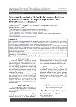
  • 1. Agus Santoso et al. Int. Journal of Engineering Research and Application www.ijera.com ISSN : 2248-9622, Vol. 6, Issue 9, ( Part -4) September 2016, pp.01-04 www.ijera.com 1|P a g e Subsurface Determination Of Cavities In Limestone Rock Area By Geoelectric Method In Tinapan Village Todanan Blora District Central Java Indonesia Agus Santoso1,2 , Sismanto3 , Ari Setiawan4 , Subagyo Pramumijoyo5 Indriati Retno Palupi2 1 Ph.D. Student, Physics Department, GadjahMada University, Indonesia 2 Geophysical Engineering, UPN "Veteran" University, Yogyakarta, Indonesia 3 Physics Department, FMIPA GadjahMada University, Indonesia 4 Physics Department, FMIPA GadjahMada University, Indonesia Geology engineering GadjahMada University, Indonesia Corresponding author: agussantoso1953@gmail.com ABSTRACT Two Dimensional of geoelectric method can be used to find out the conductive formation in the earth surface. The purpose of this research is to give the description about the geological subsurface formation, that the high resistivity value is indicate the potential area of cave and void in the limestone rocks. The dipole dipolegeoelectric method is used in this research with the path of lines is 250 m with 10 m electrode spacing. The total lines is 7 and the azimuth is from east to west. Resistivity method is started with inject the electrical current into the earth by current electrode, then potential difference will arise and measured by potential electrode. Variation value of resistance for each layer rock can calculated by divided potential defference with current value. The existence of the cavity is known by the resistivity value is more than 2500 ohm-m, while the cracks have a resistivity of 1500 to 2500 ohm-m. Keywords: Geoelectric, resistivity, dipole-dipole, ohm-m, Cavities. I. INTRODUCTION Geoelectric method is a geophysical method that learn about the flow of electricity in the subsurface and detect it in the surface of the earth. In this method there are several parameters needed, they are potential measurements, currents and electromagnetic fields. There are many kinds of geoelectricmethod, they are self potential, telluric current, magneto-teluric, electromagnetic, induced polarization and resistivity. In resistivity method, the current is injected into subsurface by the current electrode, then potential difference will arise and measured by potential electrode. The variation of spacing of the electrode can reduce the variation value of resistivity in each type of barrier layer below the measuring point. II. BASIC THEORY The basic principle of geoelectric method is Ohm’s Law, where the resistance is obtained by measuring the potential difference and current in the subsurface : (1) where R is the resistance (Ω), V is potential difference (Volt) and I is current (Ampere). Because the medium in the subsurface is very heterogeneous, so there are variety in the resistance value. It can be measured by configuration factor (K) in addition to read potential and current value. R (2) where is apparent resistivity. The implementation of resistivity method is inject the current into subsurface to potential electrode. The space of current and potential electrode is varied to get the resistivity value at any distance between them. By plotting resistivity versus electrode space, it can obtained the curve that describe functional relationship.  V I P 1 P 2 O C 1 C 2 a n a a V V Figure 1.Geoelectric dipole-dipole arrangement C1P1 = a+na = a(n+1) ; C1P2 = na C2P1 = a+na+a = a(n+2) C2P2 = na+a = a(n+1) RESEARCH ARTICLE OPEN ACCESS
  • 2. Agus Santoso et al. Int. Journal of Engineering Research and Application www.ijera.com ISSN : 2248-9622, Vol. 6, Issue 9, ( Part -4) September 2016, pp.01-04 www.ijera.com 2|P a g e 1 d )1n(a 1 na 1 )2n(a 1 )1n(a 1 2k              1 d na 1 )2n(a 1 )1n(a 2 2k             1 d )2n)(1n)(n(a )2n)(1n()1n)(n()2n)(n(2 2k           )2n)(1n)(n(ak d  (3) and apparent resistivity is : I V )2n)(1n)(n(a   (4) Geoelectric equipment The equipment used in this research are : 1. ARESdigitalresistivity meter 2. Cable 4rollswith a length ofover 300m 3. Twocurrentelectrodesand2(two) potentialelectrode 4. 12 voltbatteriesandsomedry batterytype 5. GPS(Global PositioningSystem) 6. Compassgeologyandgeologicalhammer 7. Distance measuring tool andmultimeter 8. Topographic mapsscale 1: 5000. III. DATA ACQUISITION Dipole-dipole method is used to measure the rock resistivity. Principally, injecting electrical current into subsurface it will be obtained the potential difference in the medium that contains information about rock resistivity. Current usedis preferably direct current, but to avoid the influence of the capacitance and the polarization (the tendency of rock store charge) thenusedan alternating currentof low frequency.This currentflowsinto subsurface throughtwo electrodescalled thecontactelectrodecurrent,then resultingpotential distributionthrough thepotential electrode. By knowing the current flow that caused the great potential, it can be calculated the rock resistant in the subsurface, the distance of each current and potential electrode. Figure 1 describe about the configuration of current (C1 and C2) and potential (P1 and P2) electrode. Tabel. Coordinates from : line 01 - 07 LINE Azimut h COORDINATES (UTM) Starting Point Endpoint Line- 01 N 90O E x : 0522342 y : 9227950 x : 0522590 y : 9227950 Line- N 90O E x : x : 02 0522338 y : 9227856 0522590 y : 9227853 Line- 03 N 90O E x : 0522259 y : 9227775 x : 0522495 y : 9227772 Line- 04 N 90O E x : 0522243 y : 9227714 x : 0522481 y : 9227714 Line- 05 N 0O E x : 0522607 y : 9227969 x : 0522607 y : 9227727 Line- 06 N 90O E x : 0522342 y : 9227889 x : 0522590 y : 9227885 Line- 07 N 90O E x : 0522371 y : 9227820 x : 0522624 y : 9227821 IV. GENERAL GEOLOGY 1. Geomorphology The geomorphology of the research area is include to the Rembang-Madura antiklinorium. This area can be divided into two kinds of morphological units, the first isdenudasional sloping hills and the second is steep hills structural units of anticline. In general, the research area is located in the hills with lush vegetation and the relief is not so high. The topography of this area is caused by the presence of either clastic limestone or limestone reef (reef) that located in thetop of the Bulu Formation. This area is a karst topography, there are many rivers and underground cavities in limestone reef. 2. Lithology (rock composition) Based on it’s regional stratigraphic, it is include four kinds of rock units, from the oldest to the youngest, the massive limestone unit, quartz sandstone unit, unit of organic lime stones and sandy limestones with sandstones glauconit inserts. From the regional of geology, the structure found in the area arelimestone stocky, regional fault structure that crosses the village Tinapan.Historical geological mapping of the area began in the Middle Miocene and Late Miocene ended, beginning with the deposition of limestone (Tawun Formation), followed by precipitation of quartz sandstone (Ngrayong Formation), organic lime stones (Bulu Formation), last sandy lime stones (Ledok Formation). While geological disasters that can happen is a mass movement in the form of creep and avalanches result from mining.
  • 3. Agus Santoso et al. Int. Journal of Engineering Research and Application www.ijera.com ISSN : 2248-9622, Vol. 6, Issue 9, ( Part -4) September 2016, pp.01-04 www.ijera.com 3|P a g e Lithology or rock-forming region is a limestone reef formations that are widespread throughout the Bulu Formation in Blora that located at the top of Pati carbonate composition, both clastic and non- clastic, the clastic rocks are well layered, with a thickness of 2 cm - 50 cm whereas a non clastic reef (coral reefs) with a circular shape - the circumference to form a morphological karst topography.The shape of this reef rock often forming cavity - small to large cavities that occur due to the leaching process due to groundwater or rainwater, these rocks have vug porosity, so the porosity is large enough. Besides this karst area formed the river - underground river which flows from north to south through the dams (small dams) were watery during the year. V. DATA PROCESSING AND ANALYSIS Based on the final result of this research that proseccing with Res2dinv software, it can be analized that the depth resistivitycorrelate with themagnitude ofthe real("True resistivity") of therockis dividedinto a number ofrock unitsas follows: 1.The cover layer(Soil). Resistivityranging from 50 tomorethan 1000Ω meters, consisting ofloose sand, marl, silt, gravelandgravel. 2.UnitClay/Marl Resistivityless than 10Ω meters,consisting ofmarl. Generally permeable 3.CalcareousSandUnit Resistivity value is ranging from 10 to 100Ω meters, whichcomprisescalcareoussandstonelimestoneclasti csedimentsis generally aresultof eruption ofvolcanoes. Is agoodaquifer, highly permeable, andcontainsplenty ofwaterdischarge. 4.SandyLimestoneunit. Resistivity value is ranging from 100 to 200Ω meters, consisting ofa mixture oflimestonewithorfine sandsizeupa bit rude. 5.LimestoneUnit Resistivity value is ranging from200 to 500Ω meter, limestone with fragments oflimestonebouldersthe size of5-10 mm, matrixof sandandcarbonatecement. 6.Limestonecompactunit Resistivity value is ranging from 500 to 1500Ω meters. Very compactsometimes withfragments oflimestoneboulders5-10 cm, matrixcalcareoussands, carbonatecement. 7. Cracks in limestone that have resistivity value that ranging grom 1500 to 2500 Ω meters 8. Cavitiesinlimestone. Resisitivity value is larger than 2500 Ω meter, the greaterthevalueresistivitybethe greater thecavitiesinthe rock. Figure 2. Line 01 Description: Line 01 There is no limestone cavities in rocks, here there are only rocks cracked, form a small cavity diameter less than 5 cm. Cracks located at 85-95 m, 130-135 m and 160-165 m. Figure 3. Line 02 Description: Line 02 There is nolimestonecavitiesin rocks,herethere are onlyrocks crackedat50-60m, at the depth of3- 16mand80-195mat the depth more than30 m. cracksformsmallcavitieswithdiameterless than 5cm. Figure 4. Line 03 Description: Line 03 Cavity (> 2500 Ω meters) is located on 55-60 m, 82-85 m, 103-112 m and 125-128 m in diameter 3- 10 m,at the depth of 2-6 m. At the bottom there are cavities in the limestone surrounded by sandy Bulu Formation limestone, forming limestone reefs. Figure 5. Line 04
  • 4. Agus Santoso et al. Int. Journal of Engineering Research and Application www.ijera.com ISSN : 2248-9622, Vol. 6, Issue 9, ( Part -4) September 2016, pp.01-04 www.ijera.com 4|P a g e Description: Line 04 Cavity (> 2500 ohm-m) is located on 95-105 m with the depth of 15 m until more than 31 m. found on the surface152-154 m, at a depth of 1.5 - 4 m.At the bottom there are cavities in the limestone surrounded by sandy Limestone. Figure 6. Line 05 Description: Line 05 There is nolimestonecavitiesin rocks,there are onlyrocks crackedforma smallcavitydiameterlessthan 6cm. at65-70mat the depth of9 mto 25m. On the surface.these cracksfound in55-57m, 67-74m, 81-83m, (at 155- 167mdepth12m) and227-233mwith a depthup to 5m. Figure 7. Line 06 Description: Line 06 There is nolimestonecavitiesin rocks,there are onlyrocks cracked forma smallcavitydiameterlessthan5 cm. crackslocated at86-92m, at the depthsmore than 8 m. this area isstable enoughbecause theyonly slightcrackswithoutcavity. Figure 8. Line 07 Description: 07 Cavity (> 2500 Ω meters) arequite largeat97- 150mwith the depth of29 muntil more than34 m. The top of cavity is found in142-145m, at a depth of5-7m and the bottom ofare includedrock sedimentarysandstone orclayofTawun Formation Fig 9. Location Map ofcavitiesandcracks VI. CONCLUSION Interpretation of cavity Line - 01: There is no existing cavity is formed crack rock crevices with a small hole diameter 2-5 cm. Cracks found in 85-95 m, 130-135 m and 160-165 m to more than 30 m. Line - 02:. Cracks found on the meters to 50-60 m at the depth of 3-16 m, and, on the surface of the meter to 80-195 m, at a depth that more than 30 m. Basically rock strong enough. Line - 03: no cavities - cavities in four places on the meters to 55-60 m, 82-85 m, 103-112 m, and 125-128 m, a depth of 2-6 m, to form limestone reefs / coral reefs. Line - 04: no cavities in two places on the 95-105 m, which is enough to more than 30 m somewhat enlarged. On the surface there is a small cavity at 152-154 m with a depth of 2-4 m Line - 05:. No existing cavity is formed cracks rock crevices with a small hole diameter 2-5 cm. the meters to 65-70 m at a depth of 9 m and, on the surface at the meters to 57-67 m, at a depth of 5 m. There are also cracks in the 155-165 m at the depth of 15 m. Line - 06: forming little cracks with small hole diameter 2-5 cm. the meters to 86-92 m at depths more than 8 m and, basically strong and stable rock, the rock is not hollow and little cracks only. Line - 07:. There cavity - the cavity in two places at meters to 97-150 m, which is quite large and in up to more than 30 m somewhat enlarged. On the surface there is a small cavity at 142- 145 m with a depth of 5-7 m. In this trajectory limestone reefs in the middle of the track are covered by limestone lined the edge of a path.