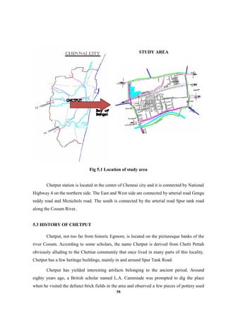
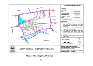
Downloaded 76 times
![28
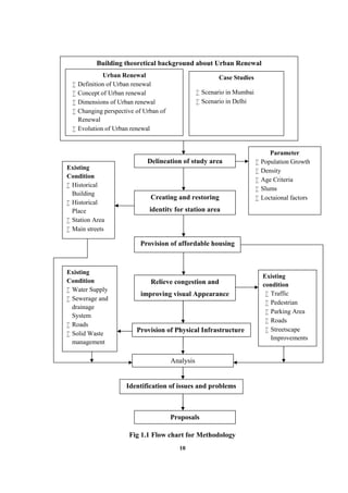
CHAPTER III
CHENNAI CITY ANALYSIS
3.1 INTRODUCTION
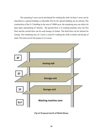
The process of modern city planning seeks to steer market forces in the city building
towards citizen welfare and the public good. Master plans and detailed development plans see
that physical pattern of land use and transportation routes within the city and for the city as a
whole. Zoning and building byelaws are still among the primary tools of such planning. In
addition, urban renewal program seeks to lay out a development or re-development or
improvement of the specific area. This urban renewal serves as a guide for public agencies to
tailor their sectoral programming to the plan while facilitating private investments in the
same manner.
Chennai the fourth largest city in India is the focus of economic, societal and ethnic
development and is the capital of the Tamil Nadu province. It is developing at a speedy rate,
and there is a need for integration of the past developments with the future demands. A co-
ordinate and integrated approach among the various authorities involved in urban
development is the demand of the hour. In this chapter, the dimension of urban renewal in
Chennai city context is analyzed for the urban center as a whole. The various dimensions of
urban renewal, physical, social, economic, legal and environmental aspects are discussed
below in Chennai city. Urban renewal plays vital part in a participatory process in planning
with equal importance and at the local body level to accomplish the aims of building this city
more livable and of international standard.
3.2 CHENNAI CITY PROFILE
Chennai situated on the shores of the Bay of Bengal is the capital of Tamil Nadu state.
It is the fourth largest metropolitan in India. Its older name ‘Madras’ was officially changed
to ‘Chennai’ in 1996. It is located [with latitude between 12°50'49" and 13°17'24", and
longitude between 79°59'53" and 80°20'12"] on the coramandal coast of southern India and
the land is a flat coastal plain.](https://image.slidesharecdn.com/edce4db0-0db7-4104-b61e-d43a1b6b1172-150312050722-conversion-gate01/85/Report-44-320.jpg)

This document is a thesis submitted by Ramachandran A for a Master's degree in Planning at Anna University, Chennai. It examines the concept of urban renewal with a focus on the Chetput Station Area in Chennai as a case study. The introduction provides background and justification for studying urban renewal. A literature review covers definitions and evolution of urban renewal concepts globally and in India. An analysis of Chennai city examines its physical, social, economic, environmental and legal aspects. The study area of Chetput Station is delineated based on population growth, density, age and location factors. An analysis of Chetput Station Area covers its demography, development pattern, infrastructure and issues. Proposals are made to restore


