Introduzione alla retta nel piano cartesianoVoglio 10
Introduzione alla retta nel piano cartesiano. si parte da una situazione problematica risolvibile conoscendo la formula per la distanza tra due punti, ossia la determinazione dell'asse di un segmento. La soluzione geometrica del problema e poi quella algebrica permettono di congetturare che le equazioni lineari rappresentino una retta.
Contare gli interi, i razionali e i reali (e altre amenità)Cristian Consonni
Dopo aver definito l’operazione di “contare” e il concetto di cardinalità
di un insieme viene delineata una dimostrazione del fatto che la cardinalità di Q è uguale a quella di N. Allo stesso modo viene tratteggiata la
dimostrazione del fatto che la cardinalità di R è maggiore di quella del
numerabile.
Il documento intende dare un significato all'unità immaginaria ed ai numeri complessi per poter meglio comprendere le applicazioni fisiche che ne fanno uso. Non mancano regole ed esercizi svolti e da svolgere.
http://youtu.be/1CQqRjs1jcE
http://youtu.be/1CQqRjs1jcE
TEOREMA DI LAGRANGE (o Teorema del valor medio) e conseguenze: dimostrazione ed esempi.
http://www.youtube.com/watch?v=1CQqRjs1jcE&feature=youtu.be
The document discusses Open History Map, which aims to create tools to teach history using modern web GIS tools. It notes challenges representing history with detail, depth, and structure. Open History Map created a map and data index to contextualize historical sources in time and space. It discusses representing changes over time from nature, mankind, and ephemeral data like photos. The future may include a public history toolkit and updating Wikidata and other databases with digital humanities data.
- OpenHistoryMap aims to create a toolchain and tools for teaching history using modern web-GIS tools. It allows representation of historical data with varying levels of detail, sources, and time periods.
- The software uses open source tools like Python, PostGIS, and Docker. Data is stored in Postgres and rendered on a tileserver for viewing maps on openhistorymap.org.
- Tools are being developed for tasks like digitizing old maps, reconciling data from different sources, and creating visualizations for educators. Future goals include integrating with Wikipedia and adding time series and 3D modeling capabilities.
The document traces the history of computing from ancient times to the present day. It discusses important figures and inventions such as Charles Babbage and Ada Lovelace, Alan Turing, the development of programmable computers at universities in the 1940s, the creation of Microsoft and Apple in the 1970s, and the rise of personal computing and the Internet. The summary highlights some of the key people and technologies that have shaped the evolution of the field over time.
This document discusses defining descriptors to simplify analysis and enable composition of features for cultural heritage applications. It presents the "divide and conquer" approach of separating the problem into maps, content and menus. Descriptors are defined for the map component, including a geocontext JSON sample defining layers and data sources to visualize geographic information. A static content JSON sample is also provided. Finally, it demonstrates existing applications and discusses installation/use of the open source front-end framework.
GEOCONTEXT AND CHCONTEXT GEOGRAPHIC INFORMATION IN CULTURAL HERITAGEMarco Montanari
Internet presence and applications are central for modern museums and cultural institutions. Even more it is important to facilitate and standardize the user experience in order to create a standard quality level and, for the institutions, it is important to simplify configuration operations bound to the creation of the visualized elements and the explorations of the spaces. This demo covers both the technologies underneath the GeoContext tool and the CHContext visualization generator as well as the possible targets and applications.
The document discusses OpenHistoricalMap (OHM), a project that aims to create an open platform for participatory and public archaeology. It summarizes OHM's approach of digitizing archaeological data at different levels of detail and tracking interpretations over time. The technology behind OHM is based on OpenStreetMap and includes additions like a tiler for digitizing paper maps and a time travel toolbar. The goal is to make archaeological research and data openly accessible and traceable.
MN-MAP is an Angular module that simplifies interacting with geographical datasets and web services by wrapping common LeafletJS operations and plugins in a simple API. It addresses the complexity of defining Angular components and directives without pure JavaScript simplicity as well as interacting with asynchronous Angular architecture. The module is an Angular4+ wrapper for LeafletJS that is plugin-aware and exposes common mapping situations through a simple API.
The document discusses using standardized metadata and APIs to generate reusable UI components for designers. It proposes using Django Rest Framework metadata and a library called GrapesJS to automatically create common components like lists and detail views. This would allow developers to write code once and designers to modify the UI without additional coding. The speaker demonstrates a prototype that transforms DRF metadata into GrapesJS components to connect APIs and user interfaces more seamlessly.
This document discusses how big data is impacting tourism. It notes that data comes from tourists, attractions, hotels, and restaurants through sensors and online activities. This data is owned by both the government and private sector, but the private sector data is more integrated with user experiences. It also discusses challenges with scraping data from major travel sites which frequently change their structures. Potential applications of big data in tourism include analyzing user behaviors, automated storytelling for destinations, and tailoring experiences based on user profiles.
The document discusses OpenHistoryMap (OHM), a public archaeology and participatory GIS project. It addresses OHM's approach to digitizing archaeological data at different levels of detail, developing a research ontology to track interpretations, and reliability of source information. The document also outlines OHM's open-source technology stack built on OpenStreetMap and its custom additions like a tiler, time travel toolbar, and Archaeological Research Database to integrate archaeological research. Finally, it invites the audience to join the open-source OHM community.
Open Data e Trasparenza come punto di contatto fra cittadinanza e politica
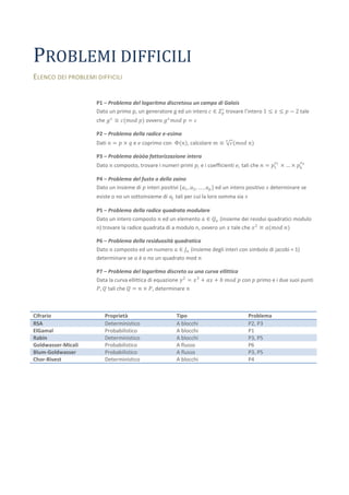
Problemi difficili
1. PROBLEMI DIFFICILI
ELENCO DEI PROBLEMI DIFFICILI
P1 – Problema del logaritmo discretosu un campo di Galois
Dato un primo p, un generatore g ed un intero 𝑐 ∈ 𝑍 ∗ trovare l’intero 1 ≤ 𝑥 ≤ 𝑝 − 2 tale
𝑝
che 𝑔 𝑥 ≡ 𝑐(𝑚𝑜𝑑 𝑝) ovvero 𝑔 𝑥 𝑚𝑜𝑑 𝑝 = 𝑐
P2 – Problema della radice e-esima
𝑒
Dati 𝑛 = 𝑝 × 𝑞 e 𝑒 coprimo con Φ(𝑛), calcolare 𝑚 ≡ 𝑐 (𝑚𝑜𝑑 𝑛)
P3 – Problema deòòa fattorizzazione intera
𝑒 𝑒
Dato 𝑛 composto, trovare i numeri primi 𝑝 𝑖 e i coefficienti 𝑒 𝑖 tali che 𝑛 = 𝑝1 1 × … × 𝑝 𝑘 𝑘
P4 – Problema del fusto o dello zaino
Dato un insieme di 𝑝 interi positivi {𝑎1 , 𝑎2 , … , 𝑎 𝑝 } ed un intero positivo 𝑠 determinare se
esiste o no un sottoinsieme di 𝑎 𝑗 tali per cui la loro somma sia 𝑠
P5 – Problema della radice quadrata modulare
Dato un intero composto 𝑛 ed un elemento 𝑎 ∈ 𝑄 𝑛 (insieme dei residui quadratici modulo
n) trovare la radice quadrata di a modulo n, ovvero un 𝑥 tale che 𝑥 2 ≡ 𝑎(𝑚𝑜𝑑 𝑛)
P6 – Problema della residuosità quadratica
Dato 𝑛 composto ed un numero 𝑎 ∈ 𝐽 𝑛 (insieme degli interi con simbolo di jacobi = 1)
determinare se 𝑎 è o no un quadrato mod 𝑛
P7 – Problema del logaritmo discreto su una curva ellittica
Data la curva ellittica di equazione 𝑦 2 = 𝑥 3 + 𝑎𝑥 + 𝑏 𝑚𝑜𝑑 𝑝 con 𝑝 primo e i due suoi punti
𝑃, 𝑄 tali che 𝑄 = 𝑛 × 𝑃, determinare 𝑛
Cifrario Proprietà Tipo Problema
RSA Deterministico A blocchi P2, P3
ElGamal Probabilistico A blocchi P1
Rabin Deterministico A blocchi P3, P5
Goldwasser-Micali Probabilistico A flusso P6
Blum-Goldwasser Probabilistico A flusso P3, P5
Chor-Rivest Deterministico A blocchi P4

![Infinitesimi ed infiniti [teoria ed esericizi][santi caltabiano]](data:image/gif;base64,R0lGODlhAQABAIAAAAAAAP///yH5BAEAAAAALAAAAAABAAEAAAIBRAA7)