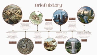
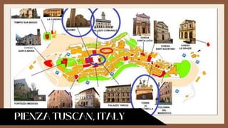
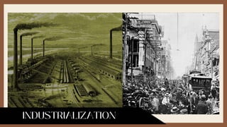
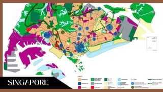
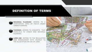
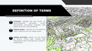
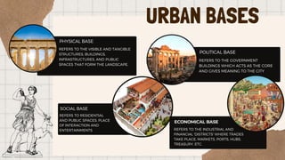
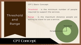
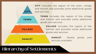
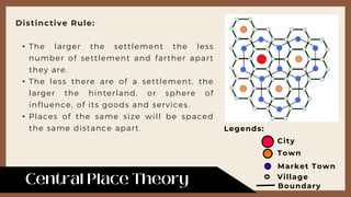
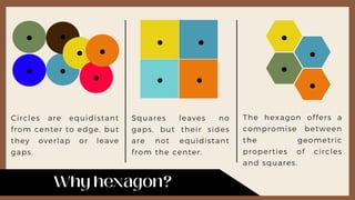
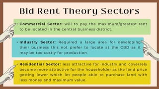
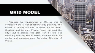
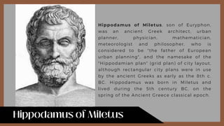
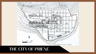
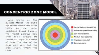
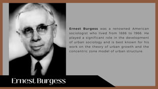
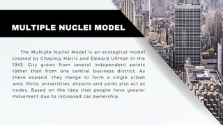
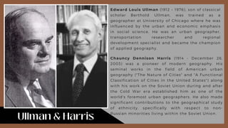
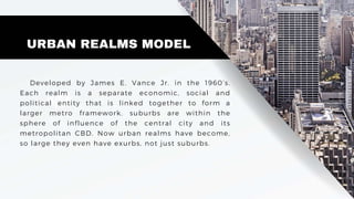
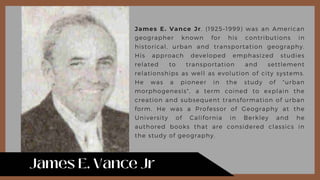
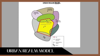
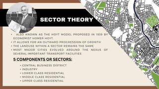
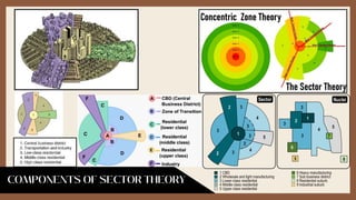
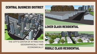
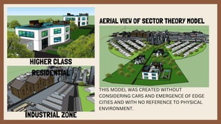
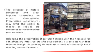
ARI. & CO.
OVERVIEW OF URBAN AND
REGIONAL PLANNING
THEORIES AND ISSUES:
ARC 142- PLANNING 3
IMPLICATIONS TO ARCHITECTURAL
PRACTICE
CONTENT
01
Brief History
02
Introduction
03
Definition of Terms
04
Urban Bases
05
URP Theories
06
URP Issues
07
Implications
to Arch. Prac,
08
Urban Fabric
Layers
09
Design
Process
10
Case Studies
11 12
Reference Proponents
27 BCE.
EARLY SETTLEMENTS -
CONFIGURED
THROUGH PRIMARY
NEEDS IN WHICH
LAYOUT ORGANICALLY
EMERGED
CLASSICAL -SHAPING
BOUNDARY AND
SPACES MORE
EVIDENTLY, SETTING
THE FOUNDATION OF
PLANNING
MEDIEVAL TO
RENAISSANCE -
CONFIGURED
THROUGH
CENTRALIZATION;
A COMMON
SHARED SPACE
CONTEMPORARY -
REVITALIZING
CENTERS AND
BOUNDARIES,
IMPROVING THE
QUALITY OF LIFE
THROUGH
PLACEMAKING.
FUTURE AND ASPIRATIONS -
UTOPIC URBAN LANDSCAPE
WITH A PLETHORA OF ENERGY
AND AN UNPARALLELED
QUALITY OF LIFE.
17TH CE.
21ST CE.
4000 BCE. 5TH CE.
19TH
CE.
2050+
MODERNISM -RISE OF
AUSTERE, ALIENATED,
AND BLEAK
SKYSCRAPERS WHICH
ARE PRIMARILY MADE OF
STEEL AND GLASS
INDUSTRIAL
REVOLUTION -
EMPHASIS ON
SANITATION AND
ZONING OF AREAS
BASED ON THEIR
FUNCTIONS
URBAN AND REGIONAL PLANNING AS A METHODOLOGICAL
APPROACH IN ACHIEVING A LIVABLE, RESPONSIVE, AND
PROGRESSIVE SOCIETY THAT ENABLES SUSTAINABLE
GROWTH WITHOUT COMPROMISING THE ECOLOGICAL IMPACT.
INTRODUCTION
THE EVER CHANGING TIMES RELENTLESSLY CALLS FOR
NEW INNOVATIONS AND SOLUTIONS FOR EXISTING AND
RISING PROBLEMS OF SOCIETY -BOTH CHALLENGES AND
OPPORTUNITIES TO CREATE AND DEVELOP A MORE
SUSTAINABLE, EFFICIENT, AND RESILIENT ENVIRONMENT
WHERE BUILT INFRASTRUCTURES, THE NATURE, AND THE
PEOPLE WORKS IN SYMBIOSIS.
01 URBAN -REFERS TO A DENSELY
POPULATED AREA WITH COMPLEX
SYSTEM.
DEFINITION OF TERMS
02 URBAN PLANNING -REFERS TO THE
STRATEGIC METHOD OF EFFECTIVELY
TRANSFORMING AN URBAN AREA IN
PURSUITS OF SUSTAINABILITY,
EFFICIENCY, ANR RESILIENCE
03 REGION -REFERS TO A CENTRAL PLACE
PLUS THE OUTLYING TERRITORIES THAT
ARE FUNCTIONALLY INTEGRATED WITH IT
(AN INTERMEDIATE AREA BETWEEN
NATIONAL AND LOCAL)
04 REGIONAL PLANNING -REFERS TO A
CATEGORICAL AREA OF FOCUS UNDER
URBAN PLANNING
DEFINITION OF TERMS
05 THEORIES -REFERS TO CONCEPTS THAT
PARALLELS TO URBAN AND REGIONAL
PLANNING.
06 LAND USE -REFERS TO THE REGULATION
AND MANAGEMENT WITH RESPECT TO
THE ALLOCATION OR USE OF LAND
07
DEFINITION OF TERMS
08
09 URBAN PATTERN -REFER TO THE WAYS
IN WHICH CITIES AND TOWNS ARE
ORGANISED AND DISTRIBUTED ACROSS A
LANDSCAPE.
ECOLOGY- REFERS TO THE STUDY OF
RELATIONSHIPS BETWEEN LIVING
ORGANISMS, INCLUDING HUMANS, AND
THEIR PHYSICAL ENVIRONMENT
URBAN BASES - REFERS TO THE ASPECTS
THAT CONSTITUTES AN URBAN AREA
A METHODOLOGICAL APPROACH IN PLANNING TOWNS
WITH STRATEGIC CONSIDERATIONS AND ANTICIPATIONS
URP THEORIES
URBAN BASES
PHYSICAL BASE
REFERS TO THE VISIBLE AND TANGIBLE
STRUCTURES, BUILDINGS,
INFRASTRUCTURES, AND PUBLIC
SPACES THAT FORM THE LANDSCAPE.
SOCIAL BASE
REFERS TO RESIDENTIAL
AND PUBLIC SPACES; PLACE
OF INTERACTION AND
ENTERTAINMENTS
POLITICAL BASE
REFERS TO THE GOVERNMENT
BUILDINGS WHICH ACTS AS THE CORE
AND GIVES MEANING TO THE CITY
ECONOMICAL BASE
REFERS TO THE INDUSTRIAL AND
FINANCIAL 'DISTRICTS' WHERE TRADES
TAKE PLACE, MARKETS, PORTS, HUBS,
TREASURY, ETC.
THEORIES OF TOWN
EMERGENCE
• THE FOUNDER OF MODERN TOWN AND
REGIONAL PLANNING.
• THE theoretical ideas of Petric Geddes have
influenced much subsequent
• planning practice, regional economic
development and environmental
management . In particular his focus on
the triad ‘Place-Work-Folk’ is
• fundamental to land use planning.
PATRICK GEDDES
October 2, 1854 - April 17, 1932
Scottish geographer,
philanthropist, town planner,
sociologist, biologist, &
comtean positivist
CENTRAL PLACE
THEORY
Central Place Theory in geography is an element
of Location Theory based on the size of
distribution of settlements within a system.
Developed by the German geographer Walter
Christaller in 1933. It explains the reasons
behind the distribution patterns, size, and
number of cities and towns. Examples. Polders
of the Netherlands, the Fens of East Anglia in
the UK
• WALTER CHRISTALLER WAS A GERMAN
GEOGRAPHER KNOWN FOR HIS
PRINCIPAL CONTRIBUTION TO THE
DICIPLINE OF CENTRAL PLACE THEORY.
• HE PUBLISHED A BOOK TITLED THE "DIE
ZENTRALEN ORTE IN SÜDDEUTSCHLAND
(THE CENTRAL PLACES IN SOUTHERN
GERMANY)" IN 1933.
WALTER CHRISTALLER
April 21, 1893 - March 9, 1969
German geographer,
What is Central Place Theory?
• It is a settlement that provide goods and services living
around it, may it be a village or a city.
• Simple basic services are said to be of lower order while
specialized services are said to be high order.
What are Central Place Theory assumptions?
• All isotropic surface.
• An evenly distributed resources
• An evenly distributed population with similar purchasing
power.
• Transportation cost equal.
CPT 2 Basic Concept:
Threshold - is the minimum number of people
required to support the services.
Range - is the maximum distance people are
willing to travel to use a service.
Threshold
Range
Threshold
and
Range
CITY
TOWN
VILLAGE
HAMLET
CITY includes the region of the town, village
and hamlet and provides some additional goods
and services
TOWN includes the region of the village
and hamlet and provides some additional
goods and services
VILLAGE includes the region of the
hamlet and provides some additional
goods and services
HAMLET fewest goods and
services available.
Legends:
Distinctive Rule:
• The larger the settlement the less
number of settlement and farther apart
they are.
• The less there are of a settlement, the
larger the hinterland, or sphere of
influence, of its goods and services.
• Places of the same size will be spaced
the same distance apart.
City
Town
Market Town
Village
Boundary
Circles are equidistant
from center to edge, but
they overlap or leave
gaps.
Squares leaves no
gaps, but their sides
are not equidistant
from the center.
The hexagon offers a
compromise between
the geometric
properties of circles
and squares.
Advantages:
• No other economic theory explains why there is a hierarchy of urban
centers.
• Describing the location of trade and service activity.
• Describing consumer market oriented manufacturing.
• Relevant information about what kind or service enterprises will likely work.
Limitations:
• Large areas of flat land rarely exist-transport is uneven.
• People and wealth are not evenly distributed
• People do not always go to the nearest place.
• Purchasing power of people differs.
• Perfect competition is unreal-some make more money than others.
• Shopping habits have changed.
PUBLIC CHOICE
THEORY
Advanced by Paul Peterson in his 1981 book, City
Limits states that urban politicians and governing
regimes are subordinate to the overall economic
principles that force cities to compete to capture
new investment and capital. The competitive nature
of cities encourages the business elite and
politicians to favour new development.
• Politics works towards the
welfare of the people.
• Government knows what
to do and it will do it.
• In a state of market failure
the next best option is
government intervention.
• Problems such as of
pollution, and such will be
controlled by the
government.
• People are rational
beings who look for
their own self-
interest. When it
comes to politics the
case is the same. They
don't suddenly become
benevolent, they strive
for their own self-
interest.
• Devleoped by James Buchanan and Tullock,
the concept of applying economics theories
to analysis the concepts of politics is the
basic idea of Public Choice Theory. It
disagrees with the idea that the people
working for the government are public
interest oriented or have a benevolent
deposition.
James Buchanan
Gordon Tullock
1. Self-Interest:
• Individuals in the political sphere, including voters, politicians, and
bureaucrats, act in their own self-interest, aiming to maximize personal
well-being.
2. Rationality:
• Individuals are assumed to be rational actors who make decisions based on
a careful consideration of costs and benefits.
3. Utility Maximization:
• Political actors seek to maximize their utility, measuring satisfaction or
well-being, influencing choices such as voting or supporting specific
policies.
4. Political Decision-Making:
• Public choice theory examines how individuals in the political system
pursue self-interest in activities like voting, lobbying, and policy
implementation.
5. Rent-Seeking:
• Individuals or groups attempt to gain economic benefits through political
means, such as lobbying or influencing government decisions.
6. Incentives and Institutions:
• Understanding incentives within different institutional frameworks is
crucial; institutions shape behavior and influence decision-making.
7. Limitations of Government:
• Public choice theory fosters skepticism about the effectiveness of
government intervention, suggesting that government actors may prioritize
self-interest over the broader public interest.
• Public choice theory originated in economics and analyzes
collective decision-making in the public sector.
• It assumes individuals act rationally, aiming to maximize their own
self-interest, even in government decisions.
• Applied to urban planning, public choice theory
offers insights into interactions among individuals,
interest groups, and policymakers in the planning
process.
How is it applicable to urban planning?
BID RENT THEORY
Geographical economic theory that refers to how
the price and demand for real estate change as the
distance from the central business district (CBD).
This is based upon the idea that retail
establishments wish to maximize their profitability,
so they are much more willing to pay more for land
close to the CBD and less for land further away from
this area. The amount they are willing to pay is
called "bid rent".
David Recardo Johann Heinrich
von Thunen
James Buchanan
First theoretician of
Bid Rent Effect.
Developed the theory
and combine it with
notion of transport
cost.
Modeled the BRT in
1964 inspired by Von
Thunen’s model.
• The Bid rent theory is a geographical economic theory that refers
to how the prices and demand for real estate change as the
distance from the central business district (CBD) increases.
• This is based upon the idea that retail establishments wish to
maximize their profitability, so they are much more willing to pay
more for land close to CBD and less for land further away from
this area.
• This theory is based upon the reasoning that more accessible area
(i.E., the greater the concentration of customers), more profitable.
• Commercial Sector: will to pay the maximum/greatest rent
to be located in the central business district.
• Industry Sector: Required a large area for developing
their business this not prefer to locate at the CBD as it
may be too costly for production.
• Residential Sector: less attractive for industry and coversely
become more attractive for the householder as the land price
getting lower which let people able to purchase land with
less money and maximum value.
THEORIES OF TOWN
ARRANGEMENTS
GRID MODEL
Proposed by Hippodamus of Miletus who is
considered the father of rational city planning. The
center of the city contains the agora (Market place),
theaters, and temples. Private rooms surround the
city’s public arenas. The plan can be laid out
uniformly over any kind of terrain since it’s based on
angles and measurements. Examples; The city of
Priene .
Hippodamus of Miletus, son of Euryphon,
was an ancient Greek architect, urban
planner, physician, mathematician,
meteorologist and philosopher, who is
considered to be "the father of European
urban planning", and the namesake of the
"Hippodamian plan" (grid plan) of city layout,
although rectangular city plans were in use
by the ancient Greeks as early as the 8th c.
BC. Hippodamus was born in Miletus and
lived during the 5th century BC, on the
spring of the Ancient Greece classical epoch.
CONCENTRIC ZONE MODEL
Also known as The
Burgess Model, The Bull's
Eye Model. Developed in the
1920's by the urban
sociologist Ernest Burgess.
The model portrays how
cities social groups are
spatially arranged in a series
of rings. The size of the
rings may vary, but the
order always remains the
same.
Ernest Burgess was a renowned American
sociologist who lived from 1886 to 1966. He
played a significant role in the development
of urban sociology and is best known for his
work on the theory of urban growth and the
concentric zone model of urban structure.
MULTIPLE NUCLEI MODEL
The Multiple Nuclei Model is an ecological model
created by Chauncy Harris and Edward Ullman in the
1945. City grows from several independent points
rather than from one central business district. As
these expand, they merge to form a single urban
area. Ports, universities, airports and parks also act as
nodes. Based on the idea that people have greater
movement due to increased car ownership.
Chauncy Dennison Harris (1914 - December 26,
2003) was a pioneer of modern geography. His
seminal works in the field of American urban
geography ("The Nature of Cities" and "A Functional
Classification of Cities in the United States") along
with his work on the Soviet Union during and after
the Cold War era established him as one of the
world's foremost urban geographers. He also made
significant contributions to the geographical study
of ethnicity, specifically with respect to non-
Russian minorities living within the Soviet Union.
Edward Louis Ullman (1912 – 1976), son of classical
scholar Berthold Ullman, was trained as a
geographer at University of Chicago where he was
influenced by the urban and economic emphasis
in social science. He was an urban geographer,
transportation researcher and regional
development specialist and became the champion
of applied geography.
URBAN REALMS MODEL
Developed by James E. Vance Jr. in the 1960’s.
Each realm is a separate economic, social and
political entity that is linked together to form a
larger metro framework. suburbs are within the
sphere of influence of the central city and its
metropolitan CBD. Now urban realms have become,
so large they even have exurbs, not just suburbs.
James E. Vance Jr. (1925–1999) was an American
geographer known for his contributions in
historical, urban and transportation geography.
His approach developed emphasized studies
related to transportation and settlement
relationships as well as evolution of city systems.
He was a pioneer in the study of "urban
morphogenesis", a term coined to explain the
creation and subsequent transformation of urban
form. He was a Professor of Geography at the
University of California in Berkley and he
authored books that are considered classics in
the study of geography.
CORE FRAME MODEL
The Core frame model is a model showing the
urban structure of the Central Business District of a
town or city. The model was first suggested by
Ronald R. Boyce and Edgar M. Horwood in 1959. The
model includes an inner core where land is
expensive and used intensively, resulting in vertical
development. The outer core and frame have lower
land values and are less intensively developed. The
various land uses are linked to the bid rent theory.
Ronald R. Boyce was an American
geographer and academic who made
significant contributions to the field of
economic geography. He authored a book
titled The Bases of Economic Geography
which was published in 1978. He was also a
professor at Seattle Pacific University.
Edgar M. Horwood was a professor of Civil
Engineering and Urban Planning at the
University of Washington, Seattle from 1960
to 1980. He was a pioneer in the
application of computers to urban
planning. In 1969, he and Ronald R. Boyce
suggested the Core Frame Model, which is
a model showing the urban structure of the
Central Business District of a town or city.
IRREGULAR PATTERN MODEL
Arrangement of Public space that characterizes
the stage of "Transition from village to city"
especially in Third World. This urban model is due to
lack of planning or construction and illegal without a
specific order. Includes blocks with no fixed order, or
permanent and temporary structures. Structures are
not related to an urban centres near the place
• CENTRAL BUSINESS DISTRICT
• INDUSTRY
• LOWER CLASS RESIDENTIAL
• MIDDLE CLASS RESIDENTIAL
• UPPER CLASS RESIDENTIAL
SECTOR THEORY
• ALSO KNOWN AS THE HOYT MODEL PROPOSED IN 1939 BY
ECONOMIST HOMER HOYT.
• IT ALLOWS FOR AN OUTWARD PROGRESSION OF GROWTH
• THE LANDUSE WITHIN A SECTOR REMAINS THE SAME
• MOST MAJOR CITIES EVOLVED AROUND THE NEXUS OF
SEVERAL IMPORTANT TRANSPORT FACILITIES
5 COMPONENTS OR SECTORS:
CENTRAL BUSINESS DISTRICT
THE CITY’S CENTER OF ATTRACTION
GEOGRAPHICALLY AND
ECONOMICALLY
MIDDLE CLASS RESIDENTIAL
LOWER CLASS RESIDENTIAL
HIGHER CLASS
RESIDENTIAL
INDUSTRIAL ZONE
AERIAL VIEW OF SECTOR THEORY MODEL
THIS MODEL WAS CREATED WITHOUT
CONSIDERING CARS AND EMERGENCE OF EDGE
CITIES AND WITH NO REFERENCE TO PHYSICAL
ENVIRONMENT.
THEORIES ON SPATIAL
INTERACTIONS
•
•
•
•
•
•
1. INDIVIDUAL CONTROL OR SMALL PARCELS OF LAND
2. Arbitrary Political Boundaries
3. Irregularity of Environmental Site
4. Heritage of Past Construction
5. Anticipation of Future Change
URP ISSUES
• Individual Control or Small
Parcels of Land:
⚬ Challenge: Urban areas
often comprise numerous
small parcels of privately
owned land, making it
challenging to implement
cohesive and efficient
development plans.
⚬ Impacts: Fragmented ownership can lead to inconsistent
development patterns hindering the implementation of
comprehensive strategies for transportation, infrastructure, and land
use.
⚬ The presence of numerous small,
privately owned parcels of land
poses challenges for
comprehensive planning.
Decisions made by individual
landowners may not align with
broader community goals, leading
to fragmented and inconsistent
development patterns. It becomes
difficult to implement
coordinated infrastructure,
transportation, and land-use plans
when ownership is dispersed.
2. Arbitrary Political Boundaries:
⚬ Challenge: Political
boundaries may not align
with functional urban
areas, leading to
coordination challenges
across jurisdictions and
difficulties in
implementing unified
planning efforts.
⚬ Impacts: Inconsistent policies and regulations between neighboring
municipalities can result in disjointed development, inefficient
resource allocation, and difficulties in addressing regional issues.
⚬ Political boundaries often do
not align with the functional
dynamics of urban areas. This
misalignment creates
challenges in implementing
unified planning efforts, as
different municipalities may
have divergent priorities and
regulations. The lack of
coordination across political
boundaries can result in
inefficient resource use,
transportation challenges, and
difficulties in addressing shared
regional issues.
3. Irregularity of Environmental
Site:
⚬ Challenge: Urban areas
may be characterized by
irregular and challenging
environmental conditions,
such as slopes, wetlands, or
flood-prone areas.
⚬ Impacts: Planning around such irregularities requires careful
consideration to avoid environmental degradation, ensure
sustainable development, and reduce the risk of natural disasters.
⚬ The presence of numerous small,
privately owned parcels of land
poses challenges for
comprehensive planning.
Decisions made by individual
landowners may not align with
broader community goals,
leading to fragmented and
inconsistent development
patterns. It becomes difficult to
implement coordinated
infrastructure, transportation,
and land-use plans when
ownership is dispersed.
4. Heritage of Past Construction:
⚬ Challenge: Historic
structures and areas may
have preservation
requirements, limiting the
scope for contemporary
development.
⚬ Impacts: Balancing the preservation of cultural heritage with the
need for modern infrastructure and development can be complex,
requiring careful planning to maintain a sense of continuity while
meeting current needs.
⚬ The presence of historic
structures and areas
imposes constraints on
urban development.
Preservation requirements
may limit the ability to
modify or replace old
structures to accommodate
modern needs.
Balancing the preservation of cultural heritage with the necessity for
contemporary infrastructure and development is a delicate task that
requires thoughtful planning to maintain a sense of continuity while
meeting current demands.
5. Anticipation of Future Change:
⚬ Challenge: Urban planning
must consider the
dynamic nature of cities,
anticipating future
changes in demographics,
technology, and economic
activities.
⚬ Impacts: Failure to account for future changes can result in outdated
infrastructure, inadequate housing, and an inability to adapt to
emerging challenges, undermining the long-term sustainability of
urban areas.
⚬ Urban areas are dynamic and
subject to continuous change
due to factors like population
growth, technological
advancements, and economic
shifts. The challenge lies in
planning for future changes that
are often unpredictable. Failure
to anticipate and adapt to
emerging trends can result in
outdated infrastructure,
insufficient housing, and an
inability to meet evolving needs,
undermining the long-term
sustainability and resilience of
urban areas.
1.Small Parcels of Land:
⚬ Implement mixed-use zoning to optimize land use efficiently.
⚬ Encourage community-led development initiatives to enhance
local collaboration.
⚬ Develop shared infrastructure and services to reduce individual
land parcel demands.
2.Arbitrary Political Boundaries:
⚬ Foster inter-municipal cooperation for coordinated regional
planning.
⚬ Establish regional planning authorities to address shared
challenges collaboratively.
⚬ Develop integrated transportation systems that span political
boundaries.
3. Irregularity of Environmental Site:
⚬ Conduct thorough environmental impact assessments before
approving projects.
⚬ Integrate sustainable drainage systems to manage water in
irregular landscapes.
⚬ Promote elevated or flood-resistant designs in flood-prone areas.
4. Heritage of Past Construction:
⚬ Implement adaptive reuse policies to preserve historic structures.
⚬ Integrate new developments harmoniously with existing heritage
buildings.
⚬ Heritage conservation districts with protective regulations.
5. Anticipation of Future Change:
⚬ Integrate climate-resilient design principles into urban planning
guidelines.
⚬ Establish early-warning systems and emergency response plans.
⚬ Use adaptive design and incorporation of technology.
⚬ Incorporate green infrastructure to mitigate climate-related risks.
⚬ Encourage the use of sustainable building materials for long-term
durability.
IMPLICATIONS TO
ARCHITECTURAL PRACTICE
P R O P O N E N T S :
PATRICK J. CASTILLO
ABD-ALQADIR AWADI
JYRAN PAT SUNDY P.
TURNOS
BERNOULLIE ELIJAH
SUMAPIG
BSARCH-IV A
AR. NUR-AISA L. MADJALES, UAP, RMP
“LEARN FROM YOUR
MISTAKES”
“HAVE FAITH”
“TRUST THE PROCESS”
I N S T R U C T O R
“YOU ONLY LIVE ONCE”
SOURCES
•
•
•
•
•
•
•
•
•
•
•
•
•
•
•
•
谢谢!
ARI. & CO.

PLANNING 3_20240130_115036_0000.pptx

  • 1.
    ARI. & CO. OVERVIEWOF URBAN AND REGIONAL PLANNING THEORIES AND ISSUES: ARC 142- PLANNING 3 IMPLICATIONS TO ARCHITECTURAL PRACTICE
  • 2.
    CONTENT 01 Brief History 02 Introduction 03 Definition ofTerms 04 Urban Bases 05 URP Theories 06 URP Issues 07 Implications to Arch. Prac, 08 Urban Fabric Layers 09 Design Process 10 Case Studies 11 12 Reference Proponents
  • 3.
    27 BCE. EARLY SETTLEMENTS- CONFIGURED THROUGH PRIMARY NEEDS IN WHICH LAYOUT ORGANICALLY EMERGED CLASSICAL -SHAPING BOUNDARY AND SPACES MORE EVIDENTLY, SETTING THE FOUNDATION OF PLANNING MEDIEVAL TO RENAISSANCE - CONFIGURED THROUGH CENTRALIZATION; A COMMON SHARED SPACE CONTEMPORARY - REVITALIZING CENTERS AND BOUNDARIES, IMPROVING THE QUALITY OF LIFE THROUGH PLACEMAKING. FUTURE AND ASPIRATIONS - UTOPIC URBAN LANDSCAPE WITH A PLETHORA OF ENERGY AND AN UNPARALLELED QUALITY OF LIFE. 17TH CE. 21ST CE. 4000 BCE. 5TH CE. 19TH CE. 2050+ MODERNISM -RISE OF AUSTERE, ALIENATED, AND BLEAK SKYSCRAPERS WHICH ARE PRIMARILY MADE OF STEEL AND GLASS INDUSTRIAL REVOLUTION - EMPHASIS ON SANITATION AND ZONING OF AREAS BASED ON THEIR FUNCTIONS
  • 14.
    URBAN AND REGIONALPLANNING AS A METHODOLOGICAL APPROACH IN ACHIEVING A LIVABLE, RESPONSIVE, AND PROGRESSIVE SOCIETY THAT ENABLES SUSTAINABLE GROWTH WITHOUT COMPROMISING THE ECOLOGICAL IMPACT. INTRODUCTION THE EVER CHANGING TIMES RELENTLESSLY CALLS FOR NEW INNOVATIONS AND SOLUTIONS FOR EXISTING AND RISING PROBLEMS OF SOCIETY -BOTH CHALLENGES AND OPPORTUNITIES TO CREATE AND DEVELOP A MORE SUSTAINABLE, EFFICIENT, AND RESILIENT ENVIRONMENT WHERE BUILT INFRASTRUCTURES, THE NATURE, AND THE PEOPLE WORKS IN SYMBIOSIS.
  • 15.
    01 URBAN -REFERSTO A DENSELY POPULATED AREA WITH COMPLEX SYSTEM. DEFINITION OF TERMS 02 URBAN PLANNING -REFERS TO THE STRATEGIC METHOD OF EFFECTIVELY TRANSFORMING AN URBAN AREA IN PURSUITS OF SUSTAINABILITY, EFFICIENCY, ANR RESILIENCE 03 REGION -REFERS TO A CENTRAL PLACE PLUS THE OUTLYING TERRITORIES THAT ARE FUNCTIONALLY INTEGRATED WITH IT (AN INTERMEDIATE AREA BETWEEN NATIONAL AND LOCAL)
  • 16.
    04 REGIONAL PLANNING-REFERS TO A CATEGORICAL AREA OF FOCUS UNDER URBAN PLANNING DEFINITION OF TERMS 05 THEORIES -REFERS TO CONCEPTS THAT PARALLELS TO URBAN AND REGIONAL PLANNING. 06 LAND USE -REFERS TO THE REGULATION AND MANAGEMENT WITH RESPECT TO THE ALLOCATION OR USE OF LAND
  • 17.
    07 DEFINITION OF TERMS 08 09URBAN PATTERN -REFER TO THE WAYS IN WHICH CITIES AND TOWNS ARE ORGANISED AND DISTRIBUTED ACROSS A LANDSCAPE. ECOLOGY- REFERS TO THE STUDY OF RELATIONSHIPS BETWEEN LIVING ORGANISMS, INCLUDING HUMANS, AND THEIR PHYSICAL ENVIRONMENT URBAN BASES - REFERS TO THE ASPECTS THAT CONSTITUTES AN URBAN AREA
  • 18.
    A METHODOLOGICAL APPROACHIN PLANNING TOWNS WITH STRATEGIC CONSIDERATIONS AND ANTICIPATIONS URP THEORIES
  • 20.
    URBAN BASES PHYSICAL BASE REFERSTO THE VISIBLE AND TANGIBLE STRUCTURES, BUILDINGS, INFRASTRUCTURES, AND PUBLIC SPACES THAT FORM THE LANDSCAPE. SOCIAL BASE REFERS TO RESIDENTIAL AND PUBLIC SPACES; PLACE OF INTERACTION AND ENTERTAINMENTS POLITICAL BASE REFERS TO THE GOVERNMENT BUILDINGS WHICH ACTS AS THE CORE AND GIVES MEANING TO THE CITY ECONOMICAL BASE REFERS TO THE INDUSTRIAL AND FINANCIAL 'DISTRICTS' WHERE TRADES TAKE PLACE, MARKETS, PORTS, HUBS, TREASURY, ETC.
  • 21.
  • 22.
    • THE FOUNDEROF MODERN TOWN AND REGIONAL PLANNING. • THE theoretical ideas of Petric Geddes have influenced much subsequent • planning practice, regional economic development and environmental management . In particular his focus on the triad ‘Place-Work-Folk’ is • fundamental to land use planning. PATRICK GEDDES October 2, 1854 - April 17, 1932 Scottish geographer, philanthropist, town planner, sociologist, biologist, & comtean positivist
  • 23.
    CENTRAL PLACE THEORY Central PlaceTheory in geography is an element of Location Theory based on the size of distribution of settlements within a system. Developed by the German geographer Walter Christaller in 1933. It explains the reasons behind the distribution patterns, size, and number of cities and towns. Examples. Polders of the Netherlands, the Fens of East Anglia in the UK
  • 24.
    • WALTER CHRISTALLERWAS A GERMAN GEOGRAPHER KNOWN FOR HIS PRINCIPAL CONTRIBUTION TO THE DICIPLINE OF CENTRAL PLACE THEORY. • HE PUBLISHED A BOOK TITLED THE "DIE ZENTRALEN ORTE IN SÜDDEUTSCHLAND (THE CENTRAL PLACES IN SOUTHERN GERMANY)" IN 1933. WALTER CHRISTALLER April 21, 1893 - March 9, 1969 German geographer,
  • 25.
    What is CentralPlace Theory? • It is a settlement that provide goods and services living around it, may it be a village or a city. • Simple basic services are said to be of lower order while specialized services are said to be high order. What are Central Place Theory assumptions? • All isotropic surface. • An evenly distributed resources • An evenly distributed population with similar purchasing power. • Transportation cost equal.
  • 26.
    CPT 2 BasicConcept: Threshold - is the minimum number of people required to support the services. Range - is the maximum distance people are willing to travel to use a service. Threshold Range Threshold and Range
  • 27.
    CITY TOWN VILLAGE HAMLET CITY includes theregion of the town, village and hamlet and provides some additional goods and services TOWN includes the region of the village and hamlet and provides some additional goods and services VILLAGE includes the region of the hamlet and provides some additional goods and services HAMLET fewest goods and services available.
  • 28.
    Legends: Distinctive Rule: • Thelarger the settlement the less number of settlement and farther apart they are. • The less there are of a settlement, the larger the hinterland, or sphere of influence, of its goods and services. • Places of the same size will be spaced the same distance apart. City Town Market Town Village Boundary
  • 29.
    Circles are equidistant fromcenter to edge, but they overlap or leave gaps. Squares leaves no gaps, but their sides are not equidistant from the center. The hexagon offers a compromise between the geometric properties of circles and squares.
  • 30.
    Advantages: • No othereconomic theory explains why there is a hierarchy of urban centers. • Describing the location of trade and service activity. • Describing consumer market oriented manufacturing. • Relevant information about what kind or service enterprises will likely work. Limitations: • Large areas of flat land rarely exist-transport is uneven. • People and wealth are not evenly distributed • People do not always go to the nearest place. • Purchasing power of people differs. • Perfect competition is unreal-some make more money than others. • Shopping habits have changed.
  • 31.
    PUBLIC CHOICE THEORY Advanced byPaul Peterson in his 1981 book, City Limits states that urban politicians and governing regimes are subordinate to the overall economic principles that force cities to compete to capture new investment and capital. The competitive nature of cities encourages the business elite and politicians to favour new development.
  • 32.
    • Politics workstowards the welfare of the people. • Government knows what to do and it will do it. • In a state of market failure the next best option is government intervention. • Problems such as of pollution, and such will be controlled by the government.
  • 33.
    • People arerational beings who look for their own self- interest. When it comes to politics the case is the same. They don't suddenly become benevolent, they strive for their own self- interest.
  • 34.
    • Devleoped byJames Buchanan and Tullock, the concept of applying economics theories to analysis the concepts of politics is the basic idea of Public Choice Theory. It disagrees with the idea that the people working for the government are public interest oriented or have a benevolent deposition. James Buchanan Gordon Tullock
  • 35.
    1. Self-Interest: • Individualsin the political sphere, including voters, politicians, and bureaucrats, act in their own self-interest, aiming to maximize personal well-being. 2. Rationality: • Individuals are assumed to be rational actors who make decisions based on a careful consideration of costs and benefits. 3. Utility Maximization: • Political actors seek to maximize their utility, measuring satisfaction or well-being, influencing choices such as voting or supporting specific policies. 4. Political Decision-Making: • Public choice theory examines how individuals in the political system pursue self-interest in activities like voting, lobbying, and policy implementation.
  • 36.
    5. Rent-Seeking: • Individualsor groups attempt to gain economic benefits through political means, such as lobbying or influencing government decisions. 6. Incentives and Institutions: • Understanding incentives within different institutional frameworks is crucial; institutions shape behavior and influence decision-making. 7. Limitations of Government: • Public choice theory fosters skepticism about the effectiveness of government intervention, suggesting that government actors may prioritize self-interest over the broader public interest.
  • 37.
    • Public choicetheory originated in economics and analyzes collective decision-making in the public sector. • It assumes individuals act rationally, aiming to maximize their own self-interest, even in government decisions. • Applied to urban planning, public choice theory offers insights into interactions among individuals, interest groups, and policymakers in the planning process. How is it applicable to urban planning?
  • 38.
    BID RENT THEORY Geographicaleconomic theory that refers to how the price and demand for real estate change as the distance from the central business district (CBD). This is based upon the idea that retail establishments wish to maximize their profitability, so they are much more willing to pay more for land close to the CBD and less for land further away from this area. The amount they are willing to pay is called "bid rent".
  • 39.
    David Recardo JohannHeinrich von Thunen James Buchanan First theoretician of Bid Rent Effect. Developed the theory and combine it with notion of transport cost. Modeled the BRT in 1964 inspired by Von Thunen’s model.
  • 40.
    • The Bidrent theory is a geographical economic theory that refers to how the prices and demand for real estate change as the distance from the central business district (CBD) increases. • This is based upon the idea that retail establishments wish to maximize their profitability, so they are much more willing to pay more for land close to CBD and less for land further away from this area. • This theory is based upon the reasoning that more accessible area (i.E., the greater the concentration of customers), more profitable.
  • 42.
    • Commercial Sector:will to pay the maximum/greatest rent to be located in the central business district. • Industry Sector: Required a large area for developing their business this not prefer to locate at the CBD as it may be too costly for production. • Residential Sector: less attractive for industry and coversely become more attractive for the householder as the land price getting lower which let people able to purchase land with less money and maximum value.
  • 43.
  • 44.
    GRID MODEL Proposed byHippodamus of Miletus who is considered the father of rational city planning. The center of the city contains the agora (Market place), theaters, and temples. Private rooms surround the city’s public arenas. The plan can be laid out uniformly over any kind of terrain since it’s based on angles and measurements. Examples; The city of Priene .
  • 45.
    Hippodamus of Miletus,son of Euryphon, was an ancient Greek architect, urban planner, physician, mathematician, meteorologist and philosopher, who is considered to be "the father of European urban planning", and the namesake of the "Hippodamian plan" (grid plan) of city layout, although rectangular city plans were in use by the ancient Greeks as early as the 8th c. BC. Hippodamus was born in Miletus and lived during the 5th century BC, on the spring of the Ancient Greece classical epoch.
  • 47.
    CONCENTRIC ZONE MODEL Alsoknown as The Burgess Model, The Bull's Eye Model. Developed in the 1920's by the urban sociologist Ernest Burgess. The model portrays how cities social groups are spatially arranged in a series of rings. The size of the rings may vary, but the order always remains the same.
  • 48.
    Ernest Burgess wasa renowned American sociologist who lived from 1886 to 1966. He played a significant role in the development of urban sociology and is best known for his work on the theory of urban growth and the concentric zone model of urban structure.
  • 49.
    MULTIPLE NUCLEI MODEL TheMultiple Nuclei Model is an ecological model created by Chauncy Harris and Edward Ullman in the 1945. City grows from several independent points rather than from one central business district. As these expand, they merge to form a single urban area. Ports, universities, airports and parks also act as nodes. Based on the idea that people have greater movement due to increased car ownership.
  • 50.
    Chauncy Dennison Harris(1914 - December 26, 2003) was a pioneer of modern geography. His seminal works in the field of American urban geography ("The Nature of Cities" and "A Functional Classification of Cities in the United States") along with his work on the Soviet Union during and after the Cold War era established him as one of the world's foremost urban geographers. He also made significant contributions to the geographical study of ethnicity, specifically with respect to non- Russian minorities living within the Soviet Union. Edward Louis Ullman (1912 – 1976), son of classical scholar Berthold Ullman, was trained as a geographer at University of Chicago where he was influenced by the urban and economic emphasis in social science. He was an urban geographer, transportation researcher and regional development specialist and became the champion of applied geography.
  • 52.
    URBAN REALMS MODEL Developedby James E. Vance Jr. in the 1960’s. Each realm is a separate economic, social and political entity that is linked together to form a larger metro framework. suburbs are within the sphere of influence of the central city and its metropolitan CBD. Now urban realms have become, so large they even have exurbs, not just suburbs.
  • 53.
    James E. VanceJr. (1925–1999) was an American geographer known for his contributions in historical, urban and transportation geography. His approach developed emphasized studies related to transportation and settlement relationships as well as evolution of city systems. He was a pioneer in the study of "urban morphogenesis", a term coined to explain the creation and subsequent transformation of urban form. He was a Professor of Geography at the University of California in Berkley and he authored books that are considered classics in the study of geography.
  • 55.
    CORE FRAME MODEL TheCore frame model is a model showing the urban structure of the Central Business District of a town or city. The model was first suggested by Ronald R. Boyce and Edgar M. Horwood in 1959. The model includes an inner core where land is expensive and used intensively, resulting in vertical development. The outer core and frame have lower land values and are less intensively developed. The various land uses are linked to the bid rent theory.
  • 56.
    Ronald R. Boycewas an American geographer and academic who made significant contributions to the field of economic geography. He authored a book titled The Bases of Economic Geography which was published in 1978. He was also a professor at Seattle Pacific University. Edgar M. Horwood was a professor of Civil Engineering and Urban Planning at the University of Washington, Seattle from 1960 to 1980. He was a pioneer in the application of computers to urban planning. In 1969, he and Ronald R. Boyce suggested the Core Frame Model, which is a model showing the urban structure of the Central Business District of a town or city.
  • 58.
    IRREGULAR PATTERN MODEL Arrangementof Public space that characterizes the stage of "Transition from village to city" especially in Third World. This urban model is due to lack of planning or construction and illegal without a specific order. Includes blocks with no fixed order, or permanent and temporary structures. Structures are not related to an urban centres near the place
  • 60.
    • CENTRAL BUSINESSDISTRICT • INDUSTRY • LOWER CLASS RESIDENTIAL • MIDDLE CLASS RESIDENTIAL • UPPER CLASS RESIDENTIAL SECTOR THEORY • ALSO KNOWN AS THE HOYT MODEL PROPOSED IN 1939 BY ECONOMIST HOMER HOYT. • IT ALLOWS FOR AN OUTWARD PROGRESSION OF GROWTH • THE LANDUSE WITHIN A SECTOR REMAINS THE SAME • MOST MAJOR CITIES EVOLVED AROUND THE NEXUS OF SEVERAL IMPORTANT TRANSPORT FACILITIES 5 COMPONENTS OR SECTORS:
  • 62.
    CENTRAL BUSINESS DISTRICT THECITY’S CENTER OF ATTRACTION GEOGRAPHICALLY AND ECONOMICALLY MIDDLE CLASS RESIDENTIAL LOWER CLASS RESIDENTIAL
  • 63.
    HIGHER CLASS RESIDENTIAL INDUSTRIAL ZONE AERIALVIEW OF SECTOR THEORY MODEL THIS MODEL WAS CREATED WITHOUT CONSIDERING CARS AND EMERGENCE OF EDGE CITIES AND WITH NO REFERENCE TO PHYSICAL ENVIRONMENT.
  • 64.
  • 65.
  • 66.
    1. INDIVIDUAL CONTROLOR SMALL PARCELS OF LAND 2. Arbitrary Political Boundaries 3. Irregularity of Environmental Site 4. Heritage of Past Construction 5. Anticipation of Future Change URP ISSUES
  • 67.
    • Individual Controlor Small Parcels of Land: ⚬ Challenge: Urban areas often comprise numerous small parcels of privately owned land, making it challenging to implement cohesive and efficient development plans. ⚬ Impacts: Fragmented ownership can lead to inconsistent development patterns hindering the implementation of comprehensive strategies for transportation, infrastructure, and land use.
  • 68.
    ⚬ The presenceof numerous small, privately owned parcels of land poses challenges for comprehensive planning. Decisions made by individual landowners may not align with broader community goals, leading to fragmented and inconsistent development patterns. It becomes difficult to implement coordinated infrastructure, transportation, and land-use plans when ownership is dispersed.
  • 69.
    2. Arbitrary PoliticalBoundaries: ⚬ Challenge: Political boundaries may not align with functional urban areas, leading to coordination challenges across jurisdictions and difficulties in implementing unified planning efforts. ⚬ Impacts: Inconsistent policies and regulations between neighboring municipalities can result in disjointed development, inefficient resource allocation, and difficulties in addressing regional issues.
  • 70.
    ⚬ Political boundariesoften do not align with the functional dynamics of urban areas. This misalignment creates challenges in implementing unified planning efforts, as different municipalities may have divergent priorities and regulations. The lack of coordination across political boundaries can result in inefficient resource use, transportation challenges, and difficulties in addressing shared regional issues.
  • 71.
    3. Irregularity ofEnvironmental Site: ⚬ Challenge: Urban areas may be characterized by irregular and challenging environmental conditions, such as slopes, wetlands, or flood-prone areas. ⚬ Impacts: Planning around such irregularities requires careful consideration to avoid environmental degradation, ensure sustainable development, and reduce the risk of natural disasters.
  • 72.
    ⚬ The presenceof numerous small, privately owned parcels of land poses challenges for comprehensive planning. Decisions made by individual landowners may not align with broader community goals, leading to fragmented and inconsistent development patterns. It becomes difficult to implement coordinated infrastructure, transportation, and land-use plans when ownership is dispersed.
  • 73.
    4. Heritage ofPast Construction: ⚬ Challenge: Historic structures and areas may have preservation requirements, limiting the scope for contemporary development. ⚬ Impacts: Balancing the preservation of cultural heritage with the need for modern infrastructure and development can be complex, requiring careful planning to maintain a sense of continuity while meeting current needs.
  • 74.
    ⚬ The presenceof historic structures and areas imposes constraints on urban development. Preservation requirements may limit the ability to modify or replace old structures to accommodate modern needs. Balancing the preservation of cultural heritage with the necessity for contemporary infrastructure and development is a delicate task that requires thoughtful planning to maintain a sense of continuity while meeting current demands.
  • 75.
    5. Anticipation ofFuture Change: ⚬ Challenge: Urban planning must consider the dynamic nature of cities, anticipating future changes in demographics, technology, and economic activities. ⚬ Impacts: Failure to account for future changes can result in outdated infrastructure, inadequate housing, and an inability to adapt to emerging challenges, undermining the long-term sustainability of urban areas.
  • 76.
    ⚬ Urban areasare dynamic and subject to continuous change due to factors like population growth, technological advancements, and economic shifts. The challenge lies in planning for future changes that are often unpredictable. Failure to anticipate and adapt to emerging trends can result in outdated infrastructure, insufficient housing, and an inability to meet evolving needs, undermining the long-term sustainability and resilience of urban areas.
  • 77.
    1.Small Parcels ofLand: ⚬ Implement mixed-use zoning to optimize land use efficiently. ⚬ Encourage community-led development initiatives to enhance local collaboration. ⚬ Develop shared infrastructure and services to reduce individual land parcel demands. 2.Arbitrary Political Boundaries: ⚬ Foster inter-municipal cooperation for coordinated regional planning. ⚬ Establish regional planning authorities to address shared challenges collaboratively. ⚬ Develop integrated transportation systems that span political boundaries.
  • 78.
    3. Irregularity ofEnvironmental Site: ⚬ Conduct thorough environmental impact assessments before approving projects. ⚬ Integrate sustainable drainage systems to manage water in irregular landscapes. ⚬ Promote elevated or flood-resistant designs in flood-prone areas. 4. Heritage of Past Construction: ⚬ Implement adaptive reuse policies to preserve historic structures. ⚬ Integrate new developments harmoniously with existing heritage buildings. ⚬ Heritage conservation districts with protective regulations.
  • 79.
    5. Anticipation ofFuture Change: ⚬ Integrate climate-resilient design principles into urban planning guidelines. ⚬ Establish early-warning systems and emergency response plans. ⚬ Use adaptive design and incorporation of technology. ⚬ Incorporate green infrastructure to mitigate climate-related risks. ⚬ Encourage the use of sustainable building materials for long-term durability.
  • 80.
  • 82.
    P R OP O N E N T S : PATRICK J. CASTILLO ABD-ALQADIR AWADI JYRAN PAT SUNDY P. TURNOS BERNOULLIE ELIJAH SUMAPIG BSARCH-IV A AR. NUR-AISA L. MADJALES, UAP, RMP “LEARN FROM YOUR MISTAKES” “HAVE FAITH” “TRUST THE PROCESS” I N S T R U C T O R “YOU ONLY LIVE ONCE”
  • 83.
  • 84.