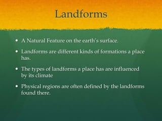
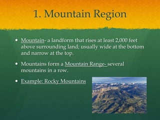
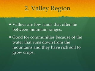
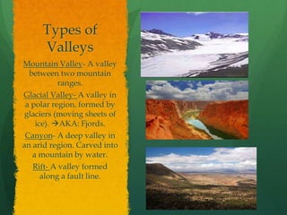
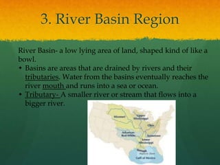
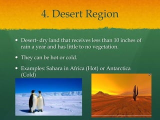
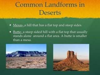
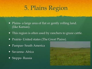
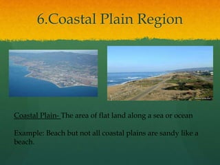
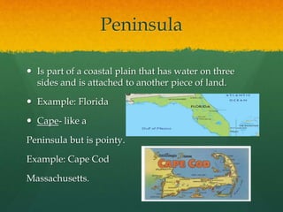
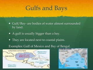
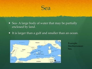
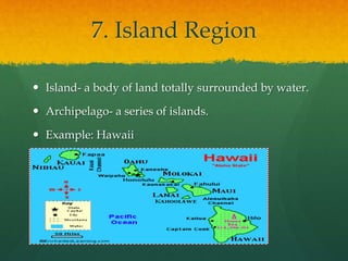
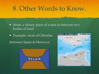
Physical Regions & 
Landforms 
What in the world is a Landform? Can you think of any examples?
What if I show you 
pictures?
Landforms 
 A Natural Feature on the earth’s surface. 
 Landforms are different kinds of formations a place 
has. 
 The types of landforms a place has are influenced 
by its climate 
 Physical regions are often defined by the landforms 
found there.
1. Mountain Region 
 Mountain- a landform that rises at least 2,000 feet 
above surrounding land; usually wide at the bottom 
and narrow at the top. 
 Mountains form a Mountain Range- several 
mountains in a row. 
 Example: Rocky Mountains
Plateau 
 Plateaus- are landforms that are found in mountain 
regions. 
 They often come off of mountains. 
 The Great Plains are located on a plateau that comes 
off the Rocky Mountains.
2. Valley Region 
 Valleys are low lands that often lie 
between mountain ranges. 
 Good for communities because of the 
water that runs down from the 
mountains and they have rich soil to 
grow crops.
Types of 
Valleys 
Mountain Valley- A valley 
between two mountain 
ranges. 
Glacial Valley- A valley in 
a polar region, formed by 
glaciers (moving sheets of 
ice). AKA: Fjords. 
Canyon- A deep valley in 
an arid region. Carved into 
a mountain by water. 
Rift- A valley formed 
along a fault line.
3. River Basin Region 
River Basin- a low lying area of land, shaped kind of like a 
bowl. 
• Basins are areas that are drained by rivers and their 
tributaries. Water from the basins eventually reaches the 
river mouth and runs into a sea or ocean. 
• Tributary- A smaller river or stream that flows into a 
bigger river.
4. Desert Region 
 Desert- dry land that receives less than 10 inches of 
rain a year and has little to no vegetation. 
 They can be hot or cold. 
 Examples: Sahara in Africa (Hot) or Antarctica 
(Cold)
Common Landforms in 
Deserts 
 Mesas- a hill that has a flat top and steep sides. 
 Butte- a steep sided hill with a flat top that usually 
stands alone around a flat area. A butte is smaller 
than a mesa.
5. Plains Region 
 Plains- a large area of flat or gently rolling land. 
(like Kansas). 
 This region is often used by ranchers to graze cattle. 
 Prairie- United states (The Great Plains). 
 Pampas- South America 
 Savanna- Africa 
 Steppe- Russia
6.Coastal Plain Region 
Coastal Plain- The area of flat land along a sea or ocean 
Example: Beach but not all coastal plains are sandy like a 
beach.
Peninsula 
 Is part of a coastal plain that has water on three 
sides and is attached to another piece of land. 
 Example: Florida 
 Cape- like a 
Peninsula but is pointy. 
Example: Cape Cod 
Massachusetts.
Gulfs and Bays 
 Gulf/Bay- are bodies of water almost surrounded 
by land. 
 A gulf is usually bigger than a bay. 
 They are located next to coastal plains. 
Examples: Gulf of Mexico and Bay of Bengal.
Sea 
 Sea- A large body of water that may be partially 
enclosed by land. 
 It is larger than a gulf and smaller than an ocean. 
Example: 
Mediterranean 
Sea.
7. Island Region 
 Island- a body of land totally surrounded by water. 
 Archipelago- a series of islands. 
 Example: Hawaii
8. Other Words to Know. 
 Strait- a skinny piece of water in between two 
bodies of land. 
 Example: strait of Gibraltar 
(between Spain & Morocco)
Isthmus 
 A skinny piece of land that attaches to a bigger 
piece of land. 
 Example: Panama  Connects Central America to 
South America.

Physical Regions and Landforms

  • 1.
    Physical Regions & Landforms What in the world is a Landform? Can you think of any examples?
  • 2.
    What if Ishow you pictures?
  • 9.
    Landforms  ANatural Feature on the earth’s surface.  Landforms are different kinds of formations a place has.  The types of landforms a place has are influenced by its climate  Physical regions are often defined by the landforms found there.
  • 10.
    1. Mountain Region  Mountain- a landform that rises at least 2,000 feet above surrounding land; usually wide at the bottom and narrow at the top.  Mountains form a Mountain Range- several mountains in a row.  Example: Rocky Mountains
  • 11.
    Plateau  Plateaus-are landforms that are found in mountain regions.  They often come off of mountains.  The Great Plains are located on a plateau that comes off the Rocky Mountains.
  • 12.
    2. Valley Region  Valleys are low lands that often lie between mountain ranges.  Good for communities because of the water that runs down from the mountains and they have rich soil to grow crops.
  • 13.
    Types of Valleys Mountain Valley- A valley between two mountain ranges. Glacial Valley- A valley in a polar region, formed by glaciers (moving sheets of ice). AKA: Fjords. Canyon- A deep valley in an arid region. Carved into a mountain by water. Rift- A valley formed along a fault line.
  • 14.
    3. River BasinRegion River Basin- a low lying area of land, shaped kind of like a bowl. • Basins are areas that are drained by rivers and their tributaries. Water from the basins eventually reaches the river mouth and runs into a sea or ocean. • Tributary- A smaller river or stream that flows into a bigger river.
  • 15.
    4. Desert Region  Desert- dry land that receives less than 10 inches of rain a year and has little to no vegetation.  They can be hot or cold.  Examples: Sahara in Africa (Hot) or Antarctica (Cold)
  • 16.
    Common Landforms in Deserts  Mesas- a hill that has a flat top and steep sides.  Butte- a steep sided hill with a flat top that usually stands alone around a flat area. A butte is smaller than a mesa.
  • 17.
    5. Plains Region  Plains- a large area of flat or gently rolling land. (like Kansas).  This region is often used by ranchers to graze cattle.  Prairie- United states (The Great Plains).  Pampas- South America  Savanna- Africa  Steppe- Russia
  • 18.
    6.Coastal Plain Region Coastal Plain- The area of flat land along a sea or ocean Example: Beach but not all coastal plains are sandy like a beach.
  • 19.
    Peninsula  Ispart of a coastal plain that has water on three sides and is attached to another piece of land.  Example: Florida  Cape- like a Peninsula but is pointy. Example: Cape Cod Massachusetts.
  • 20.
    Gulfs and Bays  Gulf/Bay- are bodies of water almost surrounded by land.  A gulf is usually bigger than a bay.  They are located next to coastal plains. Examples: Gulf of Mexico and Bay of Bengal.
  • 21.
    Sea  Sea-A large body of water that may be partially enclosed by land.  It is larger than a gulf and smaller than an ocean. Example: Mediterranean Sea.
  • 22.
    7. Island Region  Island- a body of land totally surrounded by water.  Archipelago- a series of islands.  Example: Hawaii
  • 23.
    8. Other Wordsto Know.  Strait- a skinny piece of water in between two bodies of land.  Example: strait of Gibraltar (between Spain & Morocco)
  • 24.
    Isthmus  Askinny piece of land that attaches to a bigger piece of land.  Example: Panama  Connects Central America to South America.