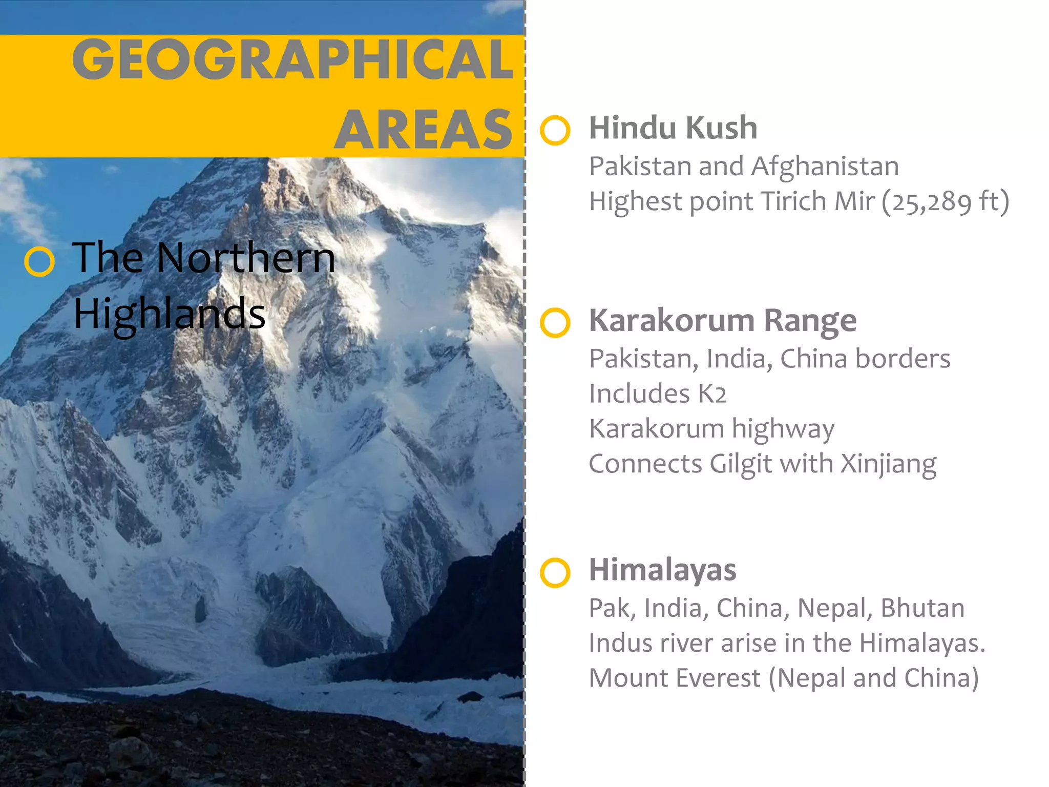
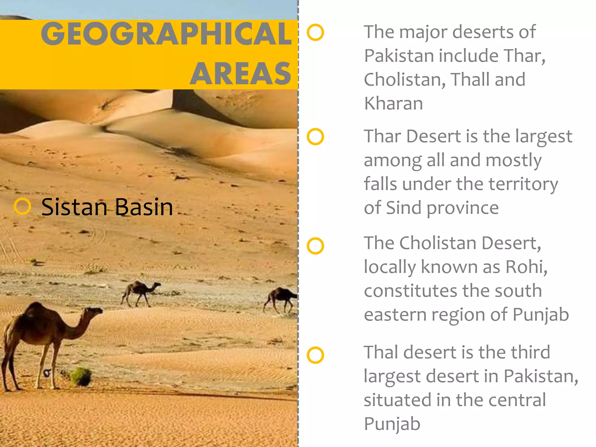
Pakistan is located in South Asia, bordering India, Afghanistan, Iran and China. It has a diverse geography that includes the Himalayan and Karakoram mountain ranges in the north and the Indus River plain in the east, which has supported major civilizations. Pakistan has a varied climate influenced by western disturbances in the winter and monsoons in the summer. It has significant natural resources including water from the Indus River system and its tributaries, extensive natural gas and petroleum reserves, coal fields, and hydropower potential. Forests cover only 4% of the land but provide important resources. Pakistan also has deposits of minerals including salt, limestone, copper and gold.
In the extreme north-East, Common border with China.
In the west , a long border known as “ Durand Line” with Afghanistan.
To the North-west “Wakhan” is a narrow strip of Afghan territory that separates Pakistan from Tajikistan.
To the South-West Pakistan has a common border with Iran.
Arabian Sea as Southern Border.
In the East, a long border with India
1:-The Northern Mountains
Pakistan Geographical Location - Pakistan Strategic WorthFaHaD .H. NooR
Pakistan Geography Location Analysis
Final Presentation #UCP
Pakistan (/ˈpækɪstæn/ (About this sound listen) or /pɑːkɪˈstɑːn/ (About this sound listen); Urdu: پاکستان), officially the Islamic Republic of Pakistan (Urdu: اسلامی جمہوریہ پاکستان), is a country in South Asia and on junction of West Asia, Central Asia and East Asia. It is the fifth-most populous country with a population exceeding 207.77 million people.[17] In terms of area, it is the 33rd-largest country spanning 881,913 square kilometres (340,509 square miles). Pakistan has a 1,046-kilometre (650-mile) coastline along the Arabian Sea and its Gulf of Oman in the south and is bordered by India to the east, Afghanistan to the west, Iran to the southwest, and China in the far northeast, respectively. It is separated narrowly from Tajikistan by Afghanistan's Wakhan Corridor in the north-west, and also shares a maritime border with Oman.
The territory that constitutes Pakistan is considered a cradle of civilisation[24][25][26][27][28] that was previously home to several ancient cultures, including the Mehrgarh of the Neolithic and the Bronze Age Indus Valley Civilisation, and later home to kingdoms ruled by people of different faiths and cultures, including Hindus, Indo-Greeks, Muslims, Turco-Mongols, Afghans, and Sikhs. The area has been ruled by numerous empires and dynasties, including the Persian Achaemenid Empire, Alexander III of Macedon, the Indian Mauryan Empire, the Arab Umayyad Caliphate, the Delhi Sultanate, the Mongol Empire, the Mughal Empire, the Afghan Durrani Empire, the Sikh Empire (partially), and most recently, the British Empire.
Pakistan is unique among Muslim countries in that it is the only country to have been created in the name of Islam.[29][30] As a result of the Pakistan Movement led by Muhammad Ali Jinnah and the subcontinent's struggle for independence, Pakistan was created in 1947 as an independent homeland for Indian Muslims.[31] It is an ethnically and linguistically diverse country, with a similarly diverse geography and wildlife. Initially a dominion, Pakistan adopted a constitution in 1956, becoming an Islamic republic. An ethnic civil war in 1971 resulted in the secession of East Pakistan as the new country of Bangladesh. In 1973 Pakistan adopted a new constitution establishing, alongside its pre-existing parliamentary republic status, a federal government based in Islamabad consisting of four provinces and four federal territories. The new constitution also stipulated that all laws were to conform to the injunctions of Islam as laid down in the Quran and Sunnah.[32]
This slide has physical features of Pakistan, important for intermediate and Metric Class students, it also includes demographic profile of Pakistan, the date on collected from Intermediate, and Metric class books, and for Demographic profile data was collected online.
land and physical features of Pakistan in detail.
>physical map of Pakistan.
>location of Pakistan
> altitude and neighboring countries.
> provinces and physical division of Pakistan.
>mountains, plains, deserts, salt range and plateaus.
> natural diversity
> river, seas, valleys, agriculture and Seasons of Pakistan .
In these slides we explained the "Geography of Pakistan" e.g landscapes
Plains
Deserts
Forests
Hills
Plateaus
Coastal areas of the Arabian Sea
Mountains
etc
Geo-strategic Worth And Location of Pakistan - CPEC - 2017FaHaD .H. NooR
CPEC Game changer
IT will help you finding why Pakistan is impotant to China. Cpec importance worth
The geography of Pakistan is a profound blend of landscapes varying from plains to deserts, forests, hills, and plateaus ranging from the coastal areas of the Arabian Sea in the south to the mountains of the Karakoram range in the north. Pakistan geologically overlaps both with the Indian and the Eurasian tectonic plates where its Sindh and Punjab provinces lie on the north-western corner of the Indian plate while Balochistan and most of the Khyber Pakhtunkhwa lie within the Eurasian plate which mainly comprises the Iranian Plateau. Gilgit-Baltistan and Azad Kashmir lie along the edge of the Indian plate and hence are prone to violent earthquakes where the two tectonic plates collide.
Pakistan is bordered by India to the east, Afghanistan to the west and Iran to the southwest while China borders the country in the northeast. The nation is geopolitically placed within some of the most controversial regional boundaries which share disputes and have many-a-times escalated military tensions between the nations, e.g., that of Kashmir with India and the Durand Line with Afghanistan. Its western borders include the Khyber Pass and Bolan Pass that have served as traditional migration routes between Central Eurasia and South Asia
This is a presentation designed for 3rd graders. There were many videos embedded in this PPT, which you will not be able to view. It was also designed in kiosk mode which allows students to view a section at a time.
An Introduction to Pakistan. Pakistan extends along either side of the historic Indus River, following its course from the mountain valleys of the Himalayas down to the Arabian Sea. Bordering on India, China, Afghanistan and Iran, it is strategically located astride the ancient trade routes between Asia and Europe.
Detail on ,
Physiography region of Pakistan, Like Mountains, Plateaus, Deserts, River system of Pakistan,
it is very important for the students of Geography & Pakistan Studies.
This project involves the study of the main factors that contributing in Pakistan floods. Statistical study of temperature and precipitation over the past 55 years conducted in three different regions of Pakistan.
India is a country of great geographical extent. It extends from 8°4’ north to 37°6’ north latitude and 68°7’ east to 97°25’ east longitude thus, it’s latitudinal and longitudinal extent is about 30 degrees.
http://www.abtutorials.com/study-modules.php
India is home to an extraordinary variety of climatic regions, ranging from tropical in the south to temperate in the Himalayan north, where elevated regions receive sustained winter snowfall. The nation's climate is strongly influenced by the Himalayas and the Thar Desert.Though the Tropic of Cancer—the boundary between the tropics and subtropics—passes through the middle of India, the bulk of the country can be regarded as climatically tropical.
We all have good and bad thoughts from time to time and situation to situation. We are bombarded daily with spiraling thoughts(both negative and positive) creating all-consuming feel , making us difficult to manage with associated suffering. Good thoughts are like our Mob Signal (Positive thought) amidst noise(negative thought) in the atmosphere. Negative thoughts like noise outweigh positive thoughts. These thoughts often create unwanted confusion, trouble, stress and frustration in our mind as well as chaos in our physical world. Negative thoughts are also known as “distorted thinking”.
Palestine last event orientationfvgnh .pptxRaedMohamed3
An EFL lesson about the current events in Palestine. It is intended to be for intermediate students who wish to increase their listening skills through a short lesson in power point.
The Indian economy is classified into different sectors to simplify the analysis and understanding of economic activities. For Class 10, it's essential to grasp the sectors of the Indian economy, understand their characteristics, and recognize their importance. This guide will provide detailed notes on the Sectors of the Indian Economy Class 10, using specific long-tail keywords to enhance comprehension.
For more information, visit-www.vavaclasses.com
The Art Pastor's Guide to Sabbath | Steve ThomasonSteve Thomason
What is the purpose of the Sabbath Law in the Torah. It is interesting to compare how the context of the law shifts from Exodus to Deuteronomy. Who gets to rest, and why?
Welcome to TechSoup New Member Orientation and Q&A (May 2024).pdfTechSoup
In this webinar you will learn how your organization can access TechSoup's wide variety of product discount and donation programs. From hardware to software, we'll give you a tour of the tools available to help your nonprofit with productivity, collaboration, financial management, donor tracking, security, and more.
Instructions for Submissions thorugh G- Classroom.pptxJheel Barad
This presentation provides a briefing on how to upload submissions and documents in Google Classroom. It was prepared as part of an orientation for new Sainik School in-service teacher trainees. As a training officer, my goal is to ensure that you are comfortable and proficient with this essential tool for managing assignments and fostering student engagement.
Unit 8 - Information and Communication Technology (Paper I).pdfThiyagu K
This slides describes the basic concepts of ICT, basics of Email, Emerging Technology and Digital Initiatives in Education. This presentations aligns with the UGC Paper I syllabus.
3. OVER VIEW
Continent: Asia
Region: South Asia,
Subcontinent
Area: Ranked 36th
Total: 796,095 km2
Land: 97.13%
Water: 2.87%
Coastline: 1,046 km
Borders
Total: 6,774 km
Afghanistan: 2,430 km
China: 523 km
India: 2,912 km
Line of Control: 740 km
Iran: 909 km
Highest Point: K2
Lowest Point: Arabian Sea
5. INTERNATIONAL
BOUNDRIES
China and Pakistan having 520
kilometers boundary.
The 8th wonder of the world:
Karakoram Highway has been
constructed at a height
of 15,397 ft between China and
Pakistan.
Iran, 800 kilometers in length
7. GEOGRAPHICAL
AREAS
The Northern
Highlands
Hindu Kush
Pakistan and Afghanistan
Highest point Tirich Mir (25,289 ft)
Karakorum Range
Pakistan, India, China borders
Includes K2
Karakorum highway
Connects Gilgit with Xinjiang
Himalayas
Pak, India, China, Nepal, Bhutan
Indus river arise in the Himalayas.
Mount Everest (Nepal and China)
8. GEOGRAPHICAL
AREAS
Indus River, one of the
greatest rivers of world
Pakistan's major rivers
the Kabul, Jhelum,
Chenab, Ravi, and Sutlej
flow into it
This area has been
inhabited by agricultural
civilizations for at least
5,000 years.
The Indus Plain
The world’s largest
irrigation network are
present in Pakistan.
9. GEOGRAPHICAL
AREAS
The major deserts of
Pakistan include Thar,
Cholistan, Thall and
Kharan
Thar Desert is the largest
among all and mostly
falls under the territory
of Sind province
The Cholistan Desert,
locally known as Rohi,
constitutes the south
eastern region of Punjab
Sistan Basin
Thal desert is the third
largest desert in Pakistan,
situated in the central
Punjab
10. CLIMATE
Western Disturbances mostly
occur during the winter months
and cause light to moderate
showers in southern parts of the
country while moderate to heavy
showers with heavy snowfall in
the northern parts of the country.
Fog occurs during the winter
season and remains for weeks in
upper Sindh, central Khyber
Pakhtunkhwa and Punjab.
Monsoon occurs in summer from
the month of June till September
in almost whole Pakistan
11. CLIMATE
Dust storms occur during summer
months with peak in May and
June, They are locally known
as Andhi. These dust storms are
quite violent. Dust storms during
the early summer indicates the
arrival of the monsoons while
dust storms in the autumn
indicate the arrival of winter.
Heat waves occur during May and
June, especially in southern
Punjab, central Balochistan and
interior Sindh.
Recently a heat stroke in Karachi
killed nearly 1500 people.
12. NATURAL
RESOURCES
Water Resources
Hydrological power is a
renewable resource which
benefits Pakistan a lot.
River Indus System is Known
as Indus System. It is divided
Into Two Plains. Upper Indus
Plain Which Starts From
Northern Pakistan and ends
Up to Mithankot.
River Jhelum, Chenab,
Sutlej, Ravi and Beas meet
at Panjnad from where they
are known as River Panjnad.
13. NATURAL
RESOURCES
Fuel Resources Pakistan has extensive
energy resources,
including natural
gas reserves, petroleum
oil reserves, coal fields
and large hydropower
potential.
14. NATURAL
RESOURCES
Forestry
About only 4% of land in
Pakistan is covered with
forests.
The forests of Pakistan
are a main source of
food, lumber, paper,
fuel, wood, latex,
medicine as well as used
for purposes of wildlife
conservation
15. NATURAL
RESOURCES
Mining
The Salt Range has large
deposits of rock salt.
Pakistan has extensive
mineral resources,
including:
limestone, silver, gold,
gems, marbles, copper,
sulfur and silica sand.