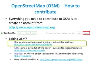
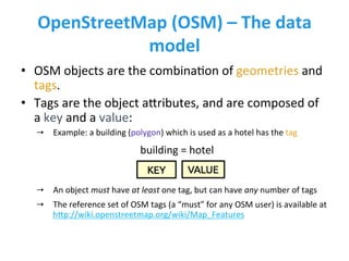
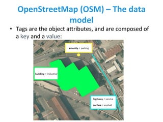
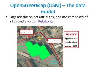
Introduc)on	
  to	
  OpenStreetMap	
  
(OSM)	
  
Mayra	
  Zurbarán	
  
With	
  support	
  from	
  GEOlab	
  and	
  
PoliMappers	
  from	
  Politecnico	
  di	
  Milano	
  
OpenStreetMap	
  (OSM)	
  –	
  What	
  is	
  it?	
  
•  The	
  most	
  popular	
  project	
  of	
  Volunteered	
  Geographic	
  
InformaAon	
  (VGI)	
  	
  
→  Founded	
  by	
  Steve	
  Coast	
  in	
  UK	
  in	
  2004:	
  	
  
hNp://wiki.openstreetmap.org/wiki/History_of_OpenStreetMap	
  	
  
→  Free,	
  editable	
  vector	
  map	
  of	
  the	
  whole	
  world	
  built	
  by	
  volunteers:	
  	
  
hNp://wiki.openstreetmap.org/wiki/About_OpenStreetMap	


h9p://openstreetmap.org	
  	
  
OpenStreetMap	
  (OSM)	
  –	
  How	
  many	
  
users?	
  	
  
•  (Jan	
  2017)	
  there	
  are	
  more	
  than	
  3	
  million	
  registered	
  
users:	
  hNp://wiki.openstreetmap.org/wiki/Stats	
  	
  
OpenStreetMap	
  (OSM)	
  –	
  License	
  	
  
•  OpenStreetMap	
  is	
  an	
  openly-­‐licensed	
  database!	
  	
  
→  OSM	
  was	
  born	
  from	
  the	
  evidence	
  that	
  many	
  geodata	
  are	
  proprietary	
  
or	
  copyrighted,	
  i.e.	
  you	
  cannot	
  freely	
  use	
  them	
  (e.g.	
  Google	
  Maps)	
  
hNp://wiki.openstreetmap.org/wiki/Why_OpenStreetMap%3F	
  	
  
→  OSM	
  is	
  licensed	
  under	
  the	
  Open	
  Database	
  License	
  (ODbL)	
  by	
  the	
  
OpenStreetMap	
  FoundaAon	
  (OSMF)	
  
hNp://opendatacommons.org/licenses/odbl/summary	


OpenStreetMap	
  (OSM)	
  –	
  How	
  to	
  
contribute	
  
•  Everything	
  you	
  need	
  to	
  contribute	
  to	
  OSM	
  is	
  to	
  
create	
  an	
  account	
  from:	
  
hNp://www.openstreetmap.org	


•  EdiAng	
  OSM?	
  	
  
→  iD:	
  a	
  simple,	
  easy-­‐to-­‐use	
  online	
  editor	
  –	
  suitable	
  for	
  beginners	
  
hNp://wiki.openstreetmap.org/wiki/ID	
  
→  JOSM:	
  a	
  more	
  powerful,	
  offline	
  editor	
  –	
  suitable	
  for	
  experienced	
  users	
  
hNps://josm.openstreetmap.de	
  	
  
→  Vespucci:	
  an	
  Android	
  editor	
  –	
  suitable	
  for	
  fast	
  and	
  efficient	
  field	
  survey	
  
hNp://vespucci.io	
  	
  
→  Many	
  others!	
  –	
  Full	
  list	
  at:	
  hNp://wiki.openstreetmap.org/wiki/Editors	
  
OpenStreetMap	
  (OSM)	
  –	
  The	
  data	
  
model	
  	
  
•  OSM	
  objects	
  are	
  the	
  
combinaAon	
  of	
  geometries	
  and	
  
tags.	
  
•  There	
  are	
  3	
  geometries	
  	
  
(hNp://wiki.openstreetmap.org/wiki/Elements)	
  :	
  	
  
→  NODE:	
  a	
  single	
  point	
  
→  WAY:	
  an	
  ordered	
  list	
  of	
  nodes	
  –	
  
Includes	
  polylines	
  and	
  polygons	
  
→  RELATION:	
  a	
  logic	
  group	
  of	
  nodes,	
  
polylines	
  &	
  polygons	
  
OpenStreetMap	
  (OSM)	
  –	
  The	
  data	
  
model	
  	
  
•  OSM	
  objects	
  are	
  the	
  combinaAon	
  of	
  geometries	
  and	
  
tags.	
  
•  Tags	
  are	
  the	
  object	
  aNributes,	
  and	
  are	
  composed	
  of	
  
a	
  key	
  and	
  a	
  value:	


→  Example:	
  a	
  building	
  (polygon)	
  which	
  is	
  used	
  as	
  a	
  hotel	
  has	
  the	
  tag	
  	
  
→  An	
  object	
  must	
  have	
  at	
  least	
  one	
  tag,	
  but	
  can	
  have	
  any	
  number	
  of	
  tags	
  	
  
→  The	
  reference	
  set	
  of	
  OSM	
  tags	
  (a	
  “must”	
  for	
  any	
  OSM	
  user)	
  is	
  available	
  at	
  
hNp://wiki.openstreetmap.org/wiki/Map_Features	
  	
  
building	
  =	
  hotel	
  
OpenStreetMap	
  (OSM)	
  –	
  The	
  data	
  
model	
  	
  
•  Tags	
  are	
  the	
  object	
  aNributes,	
  and	
  are	
  composed	
  of	
  
a	
  key	
  and	
  a	
  value:	
  
OpenStreetMap	
  (OSM)	
  –	
  The	
  data	
  
model	
  	
  
•  Tags	
  are	
  the	
  object	
  aNributes,	
  and	
  are	
  composed	
  of	
  
a	
  key	
  and	
  a	
  value	
  -­‐	
  RelaAons:	
  
OpenStreetMap	
  (OSM)	
  –	
  It’s	
  simple!	
  
10-­‐year	
  old	
  kids	
  can	
  do	
  it!	
  
Mapathon	
  at	
  
POLIMI	
  with	
  200+	
  
school	
  kids	
  
The	
  HOT	
  Tasking	
  Manager	
  
•  The	
  tool	
  designed	
  for	
  managing	
  collaboraAve	
  
humanitarian	
  mapping	
  in	
  HOT	
  and	
  Missing	
  Maps	
  
projects	
  (hNp://tasks.hotosm.org):	
  	
  
→  The	
  areas	
  to	
  be	
  mapped	
  are	
  subdivided	
  into	
  small	
  sub-­‐areas,	
  that	
  can	
  
be	
  completed	
  rapidly	
  –	
  users	
  map	
  independently	
  from	
  each	
  other	
  and	
  
in	
  different	
  areas,	
  to	
  avoid	
  conflicts!	
  
Task	
  –	
  #2631	
  
•  Missing	
  Maps:	
  Zambia	
  Malaria	
  EliminaAon	
  46	
  
→  hNp://tasks.hotosm.org/project/2631	


Help	
  create	
  an	
  UNINORTE	
  #hashtag!	
  
•  Aper	
  Mapping:	
  QuanAfying	
  the	
  mapping	
  done	
  using	
  
this	
  great	
  tool	
  from	
  Pascal	
  Neis:	
  
hNp://resultmaps.neis-­‐one.org/osm-­‐changesets	


State	
  of	
  the	
  map	
  –	
  Ramani	
  Huria	
  
Mapping	
  for	
  flood	
  resilience	
  in	
  Tanzania:	
  hNp://ramanihuria.org/	
  
Atlas	
  available	
  at:	
  hNps://issuu.com/ramanihuria/docs/ramani_huria_atlas_final	


Gracias!	
  –	
  let’s	
  map!	


OSM	
  user:	
  mazucci	
  
TwiNer	
  user:	
  @mazucci	
  

Introduction to OSM

  • 1.
    Introduc)on  to  OpenStreetMap   (OSM)   Mayra  Zurbarán   With  support  from  GEOlab  and   PoliMappers  from  Politecnico  di  Milano  
  • 2.
    OpenStreetMap  (OSM)  –  What  is  it?   •  The  most  popular  project  of  Volunteered  Geographic   InformaAon  (VGI)     →  Founded  by  Steve  Coast  in  UK  in  2004:     hNp://wiki.openstreetmap.org/wiki/History_of_OpenStreetMap     →  Free,  editable  vector  map  of  the  whole  world  built  by  volunteers:     hNp://wiki.openstreetmap.org/wiki/About_OpenStreetMap       h9p://openstreetmap.org    
  • 3.
    OpenStreetMap  (OSM)  –  How  many   users?     •  (Jan  2017)  there  are  more  than  3  million  registered   users:  hNp://wiki.openstreetmap.org/wiki/Stats    
  • 4.
    OpenStreetMap  (OSM)  –  License     •  OpenStreetMap  is  an  openly-­‐licensed  database!     →  OSM  was  born  from  the  evidence  that  many  geodata  are  proprietary   or  copyrighted,  i.e.  you  cannot  freely  use  them  (e.g.  Google  Maps)   hNp://wiki.openstreetmap.org/wiki/Why_OpenStreetMap%3F     →  OSM  is  licensed  under  the  Open  Database  License  (ODbL)  by  the   OpenStreetMap  FoundaAon  (OSMF)   hNp://opendatacommons.org/licenses/odbl/summary      
  • 5.
    OpenStreetMap  (OSM)  –  How  to   contribute   •  Everything  you  need  to  contribute  to  OSM  is  to   create  an  account  from:   hNp://www.openstreetmap.org       •  EdiAng  OSM?     →  iD:  a  simple,  easy-­‐to-­‐use  online  editor  –  suitable  for  beginners   hNp://wiki.openstreetmap.org/wiki/ID   →  JOSM:  a  more  powerful,  offline  editor  –  suitable  for  experienced  users   hNps://josm.openstreetmap.de     →  Vespucci:  an  Android  editor  –  suitable  for  fast  and  efficient  field  survey   hNp://vespucci.io     →  Many  others!  –  Full  list  at:  hNp://wiki.openstreetmap.org/wiki/Editors  
  • 6.
    OpenStreetMap  (OSM)  –  The  data   model     •  OSM  objects  are  the   combinaAon  of  geometries  and   tags.   •  There  are  3  geometries     (hNp://wiki.openstreetmap.org/wiki/Elements)  :     →  NODE:  a  single  point   →  WAY:  an  ordered  list  of  nodes  –   Includes  polylines  and  polygons   →  RELATION:  a  logic  group  of  nodes,   polylines  &  polygons  
  • 7.
    OpenStreetMap  (OSM)  –  The  data   model     •  OSM  objects  are  the  combinaAon  of  geometries  and   tags.   •  Tags  are  the  object  aNributes,  and  are  composed  of   a  key  and  a  value:       →  Example:  a  building  (polygon)  which  is  used  as  a  hotel  has  the  tag     →  An  object  must  have  at  least  one  tag,  but  can  have  any  number  of  tags     →  The  reference  set  of  OSM  tags  (a  “must”  for  any  OSM  user)  is  available  at   hNp://wiki.openstreetmap.org/wiki/Map_Features     building  =  hotel  
  • 8.
    OpenStreetMap  (OSM)  –  The  data   model     •  Tags  are  the  object  aNributes,  and  are  composed  of   a  key  and  a  value:  
  • 9.
    OpenStreetMap  (OSM)  –  The  data   model     •  Tags  are  the  object  aNributes,  and  are  composed  of   a  key  and  a  value  -­‐  RelaAons:  
  • 10.
    OpenStreetMap  (OSM)  –  It’s  simple!   10-­‐year  old  kids  can  do  it!   Mapathon  at   POLIMI  with  200+   school  kids  
  • 11.
    The  HOT  Tasking  Manager   •  The  tool  designed  for  managing  collaboraAve   humanitarian  mapping  in  HOT  and  Missing  Maps   projects  (hNp://tasks.hotosm.org):     →  The  areas  to  be  mapped  are  subdivided  into  small  sub-­‐areas,  that  can   be  completed  rapidly  –  users  map  independently  from  each  other  and   in  different  areas,  to  avoid  conflicts!  
  • 12.
    Task  –  #2631   •  Missing  Maps:  Zambia  Malaria  EliminaAon  46   →  hNp://tasks.hotosm.org/project/2631     Help  create  an  UNINORTE  #hashtag!   •  Aper  Mapping:  QuanAfying  the  mapping  done  using   this  great  tool  from  Pascal  Neis:   hNp://resultmaps.neis-­‐one.org/osm-­‐changesets      
  • 13.
    State  of  the  map  –  Ramani  Huria   Mapping  for  flood  resilience  in  Tanzania:  hNp://ramanihuria.org/   Atlas  available  at:  hNps://issuu.com/ramanihuria/docs/ramani_huria_atlas_final      
  • 14.
    Gracias!  –  let’s  map!     OSM  user:  mazucci   TwiNer  user:  @mazucci