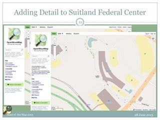
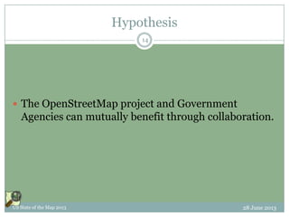
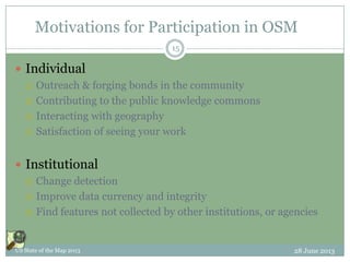
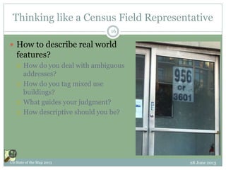
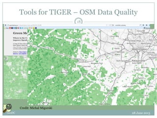
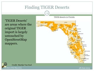
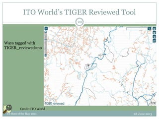
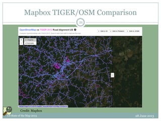
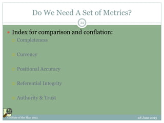
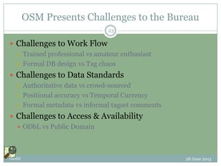
THE US CENSUS BUREAU
EXPERIENCE
OSM in Government
This document licensed in entirety by Creative Commons CC-by-SA. For specific terms of license, see:
http://creativecommons.org/licenses/by-sa/3.0/
Overview
 US Census Bureau’s TIGER/Line & OSM: the
Nexus
 Case Study
 Questions for Research
28 June 2013US State of the Map 2013
WHERE CENSUS
OPERATIONS MEET
OPENSTREETMAP
The Rational Nexus
US State of the Map 2013 28 June 2013
US Census Bureau: The Basics
 US Census Bureau is a statistical agency
 The largest Federal statistical agency
 Data is central to the Bureau’s mission
 US Census Bureau conducts:
 Censuses – a complete count
 Examples: Decennial, Economic
 Surveys – drawn from a representative sample
 Examples: American Community Survey, Current Population
Survey, American Housing Survey, etc.
 Geospatial data are essential to these operations
28 June 2013GeoDC
4
US Census Furnishes Data
 Data is at the core of the Bureau’s mission
 Data as an explicit public good
 Embodied in Mission Statement
 Strong Geospatial Component to Data:
 Master Address File
 Not public -- Protected by Title 13
 Contains position by latitude/longitude for housing units, group
quarters
 TIGER/line
 Public domain
 Transportation features, boundaries
28 June 2013US State of the Map 2013
5
A Brief History of TIGER
 Mid ‘80s, Census Bureau & USGS make 1st nationwide digital
street map with address ranges.
 Evolved into TIGER for 1990 decennial census
 Early ‘90s - Local governments bootstrap GIS with TIGER data
 Early ‘90’s - NAVTEQ, TeleAtlas started with TIGER data
 ‘96, MapQuest deploys Web-based system with street address &
map display.
 2008 - OpenStreetMap receives a jump-start by importing TIGER
 TIGER data provided a foundation for GIS and launched
the geospatial industry.
28 June 2013GeoDC
6
TIGER today…
28 June 2013US State of the Map 2013
7
The Nexus with OpenStreetMap
 OpenStreetMap is a large & growing constituency for
Census Bureau geographic data:
 Continued attention to TIGER 2012 for import
 Ongoing fixes to TIGER 2007 base
 Local knowledge used to supplement & correct TIGER
 OpenStreetMap gives Bureau professionals exposure
to geographic issues that face the Bureau:
 Locating features in the real world
 Describing real world features
 Familiarity with field-based issues
28 June 2013GeoDC
8
CASE STUDY
OpenStreetMap at Census
Bureau
US State of the Map 2013 28 June 2013
Starting an OpenStreetMap Working Group
 Informal group, multiple interests, casual to more
formal
 Working across Census Bureau organizational
divisions
 Current project: Map Suitland Federal Center
 Regular mapping parties planned through
September
28 June 2013US State of the Map 2013
10
Getting into OpenStreetMap at Census
 Experience Open Source methods of production
 Collaboration
 Gain understanding of OpenStreetMap project ethos
 Understand Field Operations
 Engage with geography on a 1:1 scale
 How do we describe real world features?
 What roles do Citizen Geographers play?
 How can the Bureau collaborate with OpenStreetMap?
 Cross-division Collaboration
 What are the geographic issues that span the Bureau
Divisions?
28 June 2013GeoDC
11
Adding Detail to Suitland Federal Center
28 June 2013State of the Map 2013
12
LINES OF INQUIRY
Research Questions
US State of the Map 2013 28 June 2013
Hypothesis
 The OpenStreetMap project and Government
Agencies can mutually benefit through collaboration.
28 June 2013US State of the Map 2013
14
Motivations for Participation in OSM
 Individual
 Outreach & forging bonds in the community
 Contributing to the public knowledge commons
 Interacting with geography
 Satisfaction of seeing your work
 Institutional
 Change detection
 Improve data currency and integrity
 Find features not collected by other institutions, or agencies
28 June 2013US State of the Map 2013
15
Thinking like a Census Field Representative
 How to describe real world
features?
 How do you deal with ambiguous
addresses?
 How do you tag mixed use
buildings?
 What guides your judgment?
 How descriptive should you be?
28 June 2013US State of the Map 2013
16
OSM – Government relationship
 The OSM community relies on Census Bureau data
 TIGER import in ’07 and subsequent refinements
 There is a large natural constituency for TIGER data
 Encouraging a community of citizen scientists can
yield benefits for the Census Bureau
 Public agencies need a constituency for their data.
 Collaboration between Census & OpenStreetMap project can
be mutually beneficial.
28 June 2013US State of the Map 2013
17
Tools for TIGER – OSM Data Quality
28 June 2013GeoDC
18
Credit: Michal Migurski
Finding TIGER Deserts
28 June 2013US State of the Map 2013
19
Credit: Martijn Van Exel
‘TIGER Deserts’
are areas where the
original TIGER
import is largely
untouched by
OpenStreetMap
mappers.
ITO World’s TIGER Reviewed Tool
28 June 2013US State of the Map 2013
20
Credit: ITO World
Ways tagged with
TIGER_reviewed=no
Mapbox TIGER/OSM Comparison
28 June 2013US State of the Map 2013
21
Credit: Mapbox
Do We Need A Set of Metrics?
 Index for comparison and conflation:
 Completeness
 Currency
 Positional Accuracy
 Referential Integrity
 Authority & Trust
28 June 2013US State of the Map 2013
22
OSM Presents Challenges to the Bureau
 Challenges to Work Flow
 Trained professional vs amateur enthusiast
 Formal DB design vs Tag chaos
 Challenges to Data Standards
 Authoritative data vs crowd-sourced
 Positional accuracy vs Temporal Currency
 Formal metadata vs informal tagset comments
 Challenges to Access & Availability
 ODbL vs Public Domain
28 June 2013GeoDC
23
Where next?
 OpenStreetMap is a large & natural constituency
 The OSM community can benefit from a better understanding
of Census Bureau operations & data
 The OSM community scrutinizes TIGER data quality
 The OSM community has made significant corrections &
additions to the original TIGER base import
 Tools are available to compare OSM & TIGER data
 The Bureau can benefit from an OSM relationship
 OSM community is a large constituency for Census data
 OSM platform for public collaboration
 Citizen engagement can augment Bureau’s location intelligence
28 June 2013US State of the Map 2013
24
Summary
 Continued investments in public data depend on
strong constituency of active users.
 For Census Bureau, OpenStreetMap offers…
 A constituency for the Bureau’s data products
 A source of citizen collaborators
 For OpenStreetMap, the Bureau offers…
 Technical expertise
 A universal mandate
28 June 2013GeoDC
25
Thank You
 Questions? Comments?
 Steven Johnson
 (e) stevejohnson@deloitte.com
 (t) @geomantic
28 June 2013US State of the Map 2013
26
This document licensed in entirety by Creative Commons CC-by-SA. For specific terms of license, see:
http://creativecommons.org/licenses/by-sa/3.0/

OpenStreetMap in Government: US Census Bureau Experience

  • 1.
    THE US CENSUSBUREAU EXPERIENCE OSM in Government This document licensed in entirety by Creative Commons CC-by-SA. For specific terms of license, see: http://creativecommons.org/licenses/by-sa/3.0/
  • 2.
    Overview  US CensusBureau’s TIGER/Line & OSM: the Nexus  Case Study  Questions for Research 28 June 2013US State of the Map 2013
  • 3.
    WHERE CENSUS OPERATIONS MEET OPENSTREETMAP TheRational Nexus US State of the Map 2013 28 June 2013
  • 4.
    US Census Bureau:The Basics  US Census Bureau is a statistical agency  The largest Federal statistical agency  Data is central to the Bureau’s mission  US Census Bureau conducts:  Censuses – a complete count  Examples: Decennial, Economic  Surveys – drawn from a representative sample  Examples: American Community Survey, Current Population Survey, American Housing Survey, etc.  Geospatial data are essential to these operations 28 June 2013GeoDC 4
  • 5.
    US Census FurnishesData  Data is at the core of the Bureau’s mission  Data as an explicit public good  Embodied in Mission Statement  Strong Geospatial Component to Data:  Master Address File  Not public -- Protected by Title 13  Contains position by latitude/longitude for housing units, group quarters  TIGER/line  Public domain  Transportation features, boundaries 28 June 2013US State of the Map 2013 5
  • 6.
    A Brief Historyof TIGER  Mid ‘80s, Census Bureau & USGS make 1st nationwide digital street map with address ranges.  Evolved into TIGER for 1990 decennial census  Early ‘90s - Local governments bootstrap GIS with TIGER data  Early ‘90’s - NAVTEQ, TeleAtlas started with TIGER data  ‘96, MapQuest deploys Web-based system with street address & map display.  2008 - OpenStreetMap receives a jump-start by importing TIGER  TIGER data provided a foundation for GIS and launched the geospatial industry. 28 June 2013GeoDC 6
  • 7.
    TIGER today… 28 June2013US State of the Map 2013 7
  • 8.
    The Nexus withOpenStreetMap  OpenStreetMap is a large & growing constituency for Census Bureau geographic data:  Continued attention to TIGER 2012 for import  Ongoing fixes to TIGER 2007 base  Local knowledge used to supplement & correct TIGER  OpenStreetMap gives Bureau professionals exposure to geographic issues that face the Bureau:  Locating features in the real world  Describing real world features  Familiarity with field-based issues 28 June 2013GeoDC 8
  • 9.
    CASE STUDY OpenStreetMap atCensus Bureau US State of the Map 2013 28 June 2013
  • 10.
    Starting an OpenStreetMapWorking Group  Informal group, multiple interests, casual to more formal  Working across Census Bureau organizational divisions  Current project: Map Suitland Federal Center  Regular mapping parties planned through September 28 June 2013US State of the Map 2013 10
  • 11.
    Getting into OpenStreetMapat Census  Experience Open Source methods of production  Collaboration  Gain understanding of OpenStreetMap project ethos  Understand Field Operations  Engage with geography on a 1:1 scale  How do we describe real world features?  What roles do Citizen Geographers play?  How can the Bureau collaborate with OpenStreetMap?  Cross-division Collaboration  What are the geographic issues that span the Bureau Divisions? 28 June 2013GeoDC 11
  • 12.
    Adding Detail toSuitland Federal Center 28 June 2013State of the Map 2013 12
  • 13.
    LINES OF INQUIRY ResearchQuestions US State of the Map 2013 28 June 2013
  • 14.
    Hypothesis  The OpenStreetMapproject and Government Agencies can mutually benefit through collaboration. 28 June 2013US State of the Map 2013 14
  • 15.
    Motivations for Participationin OSM  Individual  Outreach & forging bonds in the community  Contributing to the public knowledge commons  Interacting with geography  Satisfaction of seeing your work  Institutional  Change detection  Improve data currency and integrity  Find features not collected by other institutions, or agencies 28 June 2013US State of the Map 2013 15
  • 16.
    Thinking like aCensus Field Representative  How to describe real world features?  How do you deal with ambiguous addresses?  How do you tag mixed use buildings?  What guides your judgment?  How descriptive should you be? 28 June 2013US State of the Map 2013 16
  • 17.
    OSM – Governmentrelationship  The OSM community relies on Census Bureau data  TIGER import in ’07 and subsequent refinements  There is a large natural constituency for TIGER data  Encouraging a community of citizen scientists can yield benefits for the Census Bureau  Public agencies need a constituency for their data.  Collaboration between Census & OpenStreetMap project can be mutually beneficial. 28 June 2013US State of the Map 2013 17
  • 18.
    Tools for TIGER– OSM Data Quality 28 June 2013GeoDC 18 Credit: Michal Migurski
  • 19.
    Finding TIGER Deserts 28June 2013US State of the Map 2013 19 Credit: Martijn Van Exel ‘TIGER Deserts’ are areas where the original TIGER import is largely untouched by OpenStreetMap mappers.
  • 20.
    ITO World’s TIGERReviewed Tool 28 June 2013US State of the Map 2013 20 Credit: ITO World Ways tagged with TIGER_reviewed=no
  • 21.
    Mapbox TIGER/OSM Comparison 28June 2013US State of the Map 2013 21 Credit: Mapbox
  • 22.
    Do We NeedA Set of Metrics?  Index for comparison and conflation:  Completeness  Currency  Positional Accuracy  Referential Integrity  Authority & Trust 28 June 2013US State of the Map 2013 22
  • 23.
    OSM Presents Challengesto the Bureau  Challenges to Work Flow  Trained professional vs amateur enthusiast  Formal DB design vs Tag chaos  Challenges to Data Standards  Authoritative data vs crowd-sourced  Positional accuracy vs Temporal Currency  Formal metadata vs informal tagset comments  Challenges to Access & Availability  ODbL vs Public Domain 28 June 2013GeoDC 23
  • 24.
    Where next?  OpenStreetMapis a large & natural constituency  The OSM community can benefit from a better understanding of Census Bureau operations & data  The OSM community scrutinizes TIGER data quality  The OSM community has made significant corrections & additions to the original TIGER base import  Tools are available to compare OSM & TIGER data  The Bureau can benefit from an OSM relationship  OSM community is a large constituency for Census data  OSM platform for public collaboration  Citizen engagement can augment Bureau’s location intelligence 28 June 2013US State of the Map 2013 24
  • 25.
    Summary  Continued investmentsin public data depend on strong constituency of active users.  For Census Bureau, OpenStreetMap offers…  A constituency for the Bureau’s data products  A source of citizen collaborators  For OpenStreetMap, the Bureau offers…  Technical expertise  A universal mandate 28 June 2013GeoDC 25
  • 26.
    Thank You  Questions?Comments?  Steven Johnson  (e) stevejohnson@deloitte.com  (t) @geomantic 28 June 2013US State of the Map 2013 26 This document licensed in entirety by Creative Commons CC-by-SA. For specific terms of license, see: http://creativecommons.org/licenses/by-sa/3.0/