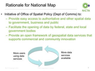
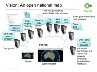
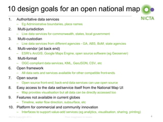
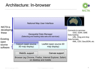
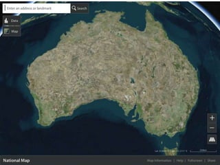
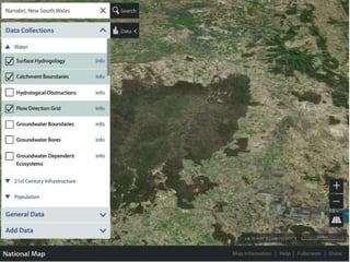
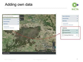
The document discusses the rationale and design goals for a proposed National Map of Australia. The National Map is an initiative to provide easy access to authoritative and other spatial data from all levels of government through an open framework. It will allow users to access maps, imagery, and geospatial data from various agencies through a single web interface. The proposed architecture is an in-browser system that connects users to multiple data services from different jurisdictions and vendors using open source mapping libraries. It will support adding additional data services and user-generated content over time.
1. NICTA Copyright 2013 From imagination to impact
National Map
Overview
Tim Mackey (GA)
3 June 2014
2. NICTA Copyright 2013 From imagination to impact
Rationale for National Map
• Initiative of Office of Spatial Policy (Dept of Comms) to:
– Provide easy access to authoritative and other spatial data
to government, business and public
– Facilitate the opening of data by federal, state and local
government bodies
– Provide an open framework of geospatial data services that
supports commercial and community innovation
2
More users
using data
services
More data
services
available
3. NICTA Copyright 2013 From imagination to impact
Map browser
code and
data mgmt
Govt open
data
directory
Vision: An open national map
3
Web browser
…
Value-add
commercial and
community
services
(analytics,
visualisations,
mashups)
Map
imagery
Tile map
server
Elevation
data
Terrain
server
C/wealth govt agency
authoritative data services
Internet
Tablet
Other data
and
services
Data.gov.au
ABS
data
GA
data
BoM
data
…
State govt authoritative
data services
WA
data
QLD
data
State
data
…
4. NICTA Copyright 2013 From imagination to impact
10 design goals for an open national map
1. Authoritative data services
– Eg Administrative boundaries, place names
2. Multi-jurisdiction
– Live data services for commonwealth, states, local government
3. Multi-custodian
– Live data services from different agencies - GA, ABS, BoM, state agencies
4. Multi-vendor (at back end)
– ESRI’s ArcGIS, Google Maps Engine, open source software (eg Geoserver)
5. Multi-format
– OGC-compliant data services, KML, GeoJSON, CSV, etc
6. Open framework
– All data sets and services available for other compatible front-ends
7. Open source
– Open source front-end; back-end data services can use open source
8. Easy access to the data set/service itself from the National Map UI
– Map provides visualisation but all data can be directly accessed too
9. Features not available in current globes
– Timeline, water flow direction, subsurface, etc
10. Platform for commercial and community innovation
– Interfaces to support value-add services (eg analytics, visualisation, sharing, printing)
4
5. NICTA Copyright 2013 From imagination to impact
Existing
open
source
software
Architecture: In-browser
5
Browser (eg Chrome, Firefox, Internet Explorer, Safari)
on desktop and mobile
National Map User Interface
Leaflet (open source 2D
map display)
Geospatial Data Manager
(Selecting and loading data sets and services)
Cesium (open source
3D map display)
NICTA is
developing
these
Connects to services:
OGC, ESRI, GME
Data loading:
URL, Drag and drop
Data formats:
KML, CSV, GeoJSON, etc
Canvas supportWebGL support
10. NICTA Copyright 2013 From imagination to impact
Current available data services
• All now available from their custodian and in National Map
• Land (Geoscience Australia)
– Gravity, land cover, magnetic image, surface geology, hillshade
• Water (Bureau of Meteorology’s Geofabric)
– Water bodies, streams and rivers, catchments, estuaries, boreholes, waterholes,
river regions, drainage divisions, aquifer contours, water table aquifers
• Infrastructure (Geoscience Australia’s Geotopo 250k)
– Roads, railroads, airports, ferry routes, pipelines, power lines
• Boundaries (Australian Bureau of Statistics)
– States and territories, local government areas, postal areas, commonwealth
electoral divisions, state electoral divisions, state suburbs, natural resource
management regions, Australian drainage divisions, tourism regions, statistical
boundaries
• Population (Geoscience Australia)
– Cities
– Populated places
• Other data sets and services at data.gov.au
• Lots more coming!
10
11. NICTA Copyright 2013 From imagination to impact
National Map status
• Beta will be released in time for Govhack
(11-13 July)
• Any custodian wanting their data set or
service in the National Map…
– Add it to data.gov.au; and
– Email nationalmap@lists.nicta.com.au or
contact bill.simpson-young@nicta.com.au
11