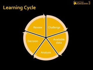
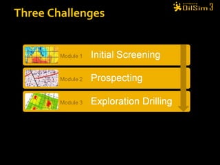
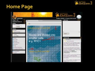
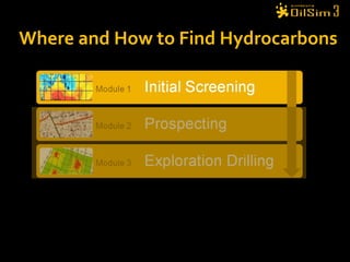
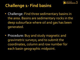
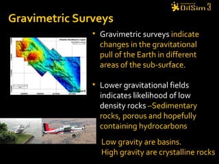
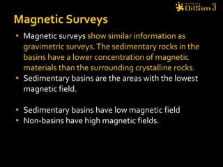
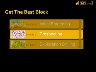
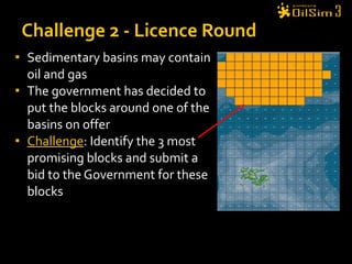
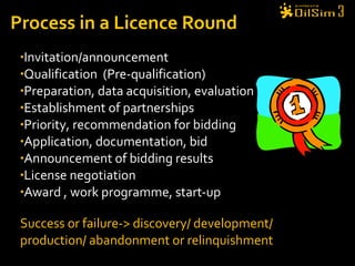
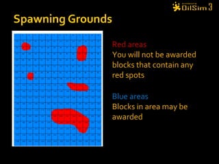
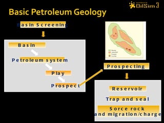
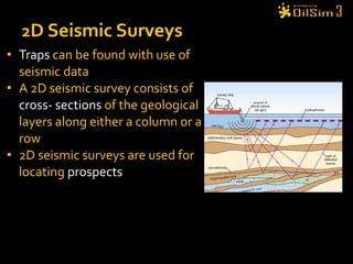
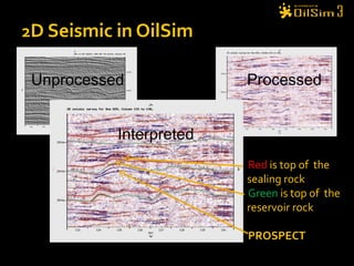
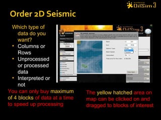
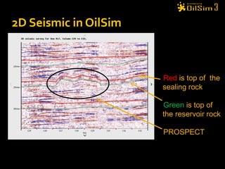
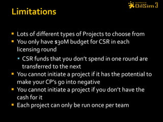
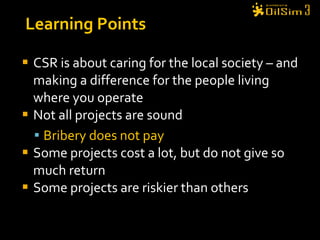
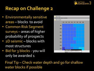
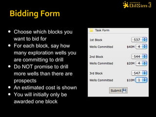
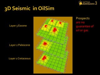
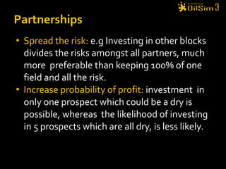
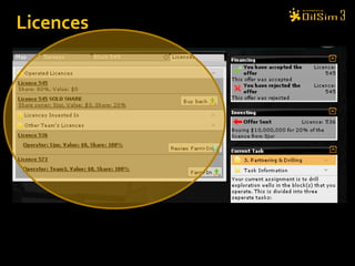
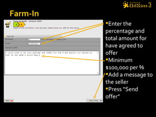
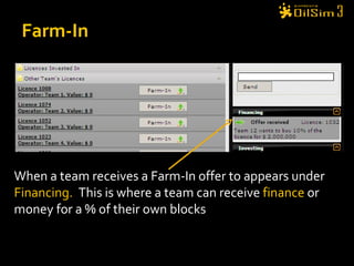
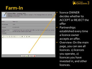
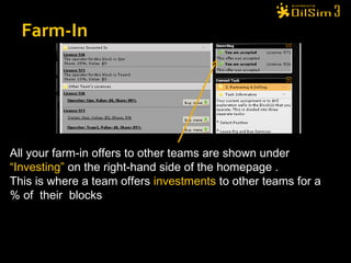
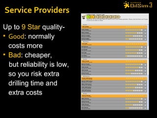
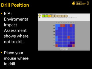
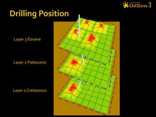
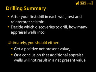
The document provides instructions for participants in an oil and gas simulation game called OilSim. It outlines three main challenges: 1) finding sedimentary basins using magnetic and gravity surveys, 2) identifying and bidding on the most promising exploration blocks near a basin, and 3) reducing risk through partnerships while acquiring seismic data and drilling exploration/appraisal wells. The goal is to make economically viable hydrocarbon discoveries and maximize the net value of license blocks.
The document discusses various aspects of oil and gas exploration, including:
1) Finding sedimentary basins using magnetic and gravity surveys and submitting the coordinates of three basin centers.
2) Identifying the most promising oil and gas blocks and bidding on licenses to drill exploration wells.
3) Choosing corporate social responsibility projects to increase credibility points to improve chances of winning licenses.
4) Farming into other licenses by investing a percentage in exchange for a share of future revenues.
The document discusses various aspects of oil exploration and production, including:
1) Teams are tasked with finding sedimentary basins using magnetic and gravity surveys to earn credibility points.
2) Teams then bid on blocks near identified basins and choose corporate social responsibility projects to increase points for license awards.
3) Licensed blocks can be farmout to acquire funding and farmin to other blocks to spread risk, with the goal of drilling exploration and appraisal wells to prove oil reserves.
The document provides instructions for an oil exploration simulation game. Players take on the role of an exploration team tasked with discovering oil and gas reserves through licensing blocks, acquiring surveys, drilling wells, and managing finances. The goal is to maximize profit by finding hydrocarbons, developing any discoveries, and hedging risk through partnerships while balancing costs. Players must make strategic decisions around exploration, appraisal, development, and joint ventures to be successful.
This document provides an overview of OilSim, a simulation for the oil and gas upstream value chain. It describes the learning objectives, challenges, and tasks involved in exploring for and developing oil and gas resources. The tasks include locating sedimentary basins using surveys, bidding on exploration licenses, acquiring seismic data, drilling exploration and appraisal wells to evaluate discoveries, and developing field production plans to maximize resource recovery. The goal is to make economically viable decisions that consider costs, risks, environmental factors, and partnerships with other teams.
The document provides an overview of OilSim, a simulation for the oil and gas upstream value chain. It describes the learning objectives, challenges, and tasks involved in exploring for and developing oil and gas fields. The tasks include identifying sedimentary basins using surveys, bidding on exploration licenses, partnering to share risks and costs, 3D seismic analysis, exploration drilling, appraising discoveries, and developing field production plans. The goal is to maximize the net value of discoveries through correct decisions and efficient operations while gaining experience in the upstream process.
This document provides information about an oil and gas exploration simulation game called PetroChallenge IPAA 2011. The simulation allows participants to take on the role of an exploration team with the goal of maximizing returns through various exploration and development activities. These include identifying sedimentary basins using surveys, bidding on licenses, acquiring partnerships through farm-ins and farm-outs, drilling exploration wells using various rigs and service providers, analyzing drilling results, and calculating field value. The game aims to enhance understanding of the full petroleum exploration and field development process.
Petro challengefinal 2010 ppt presentationMeghan Clark
The document provides information about an oil and gas exploration simulation game called International PetroChallenge2010. Players take on the role of an exploration team with the goal of maximizing financial returns through discovering and developing oil and gas reserves. The simulation involves multiple tasks such as identifying sedimentary basins using surveys, bidding on exploration licenses, partnering with other teams, drilling exploration wells, and calculating the value of any discovered resources. Players can learn about key aspects of the oil and gas industry through participating in the simulation.
Opito petrochallenge 2010 offshore presentationMeghan Clark
The document provides an introduction to oil and gas exploration through a simulation game. It outlines the objectives to maximize return on investment and credibility points. It describes key steps like identifying sedimentary basins using surveys, bidding on licenses, partnering through farm-ins and farm-outs to spread risk, drilling exploration wells using appropriate rigs and service providers, and applying for additional funds. The goal is to discover and appraise hydrocarbon volumes through repeated exploration cycles to determine proven reserves.
Updated op ex power-point 22nd march 2011Meghan Clark
This document provides an overview and agenda for a three-part learning simulation about the oil and gas industry called OilSim. The simulation uses a team-based challenge where participants take on the role of an exploration team tasked with finding and drilling for new oil reserves. It outlines the objectives to learn about exploration, drilling, partnerships, licensing rounds, and applying business strategies. The agenda includes challenges to find sedimentary basins, identify promising blocks, form partnerships, conduct drilling, and participate in additional licensing rounds. It describes the evaluation of teams based on return on investment and credibility points awarded for correct decisions.
Offshore - Dubai -Introduction to ExplorationMeghan Clark
The team is given $200 million to explore for oil and gas in a new petroleum province through activities like acquiring surveys, locating sedimentary basins, bidding on blocks, drilling exploratory wells, and seeking partnerships. The goal is to maximize the net value of discovered hydrocarbons minus all costs. Knowledge points are earned for correct decisions and can be used to get funds or bid on better blocks in future licensing rounds. The document provides guidance on the exploration and field development process.
The document provides instructions for an exploration team on their tasks in finding and drilling for new petroleum reserves. The team's objective is to maximize return on investment. They are given $50 million to start and can apply for more funds later. Teams explore areas, identify sedimentary basins using surveys, bid on exploration licenses, drill wells using rigs, and can partner with other teams to share risks and rewards. The goal is to discover oil and gas fields and achieve the highest profit relative to funds received.
The document provides information about using an oil and gas simulation game to learn about the oil and gas industry. It describes various challenges in the simulation that involve exploring for oil and gas, including identifying sedimentary basins, acquiring seismic data, bidding on exploration licenses, drilling wells, and planning production facilities. The goal is to maximize the net value of discovered oil and gas fields while gaining experience in decision making, teamwork, and evaluating economic and environmental factors.
Here are the key steps to follow based on the exploration results:
1. Reprocess seismic data for your discovery to better define the reservoir.
2. Drill at least one appraisal well into your largest discovery to determine if it can be commercially developed based on the size of recoverable reserves.
3. If the appraisal well looks promising, consider drilling a second appraisal well to further assess the field size.
4. Once you have a better understanding of the field size from appraisal drilling, evaluate if development costs can be recovered from future production revenues based on current oil/gas prices.
5. If the field is economically viable, proceed with field development planning. Otherwise, consider selling the license
The document provides information about an oil and gas simulation game. It describes challenges around finding sedimentary basins, bidding on exploration licenses, acquiring 3D seismic data, developing well plans, and designing production facilities. The goal is to maximize the net value of discovered oil and gas fields by making correct decisions that balance costs, production, the environment, and risk.
The document provides an overview of an onshore oil and gas exploration simulation. Players take on the role of an exploration team tasked with finding and drilling for reserves to maximize return on investment. The simulation involves completing challenges such as identifying sedimentary basins using surveys, bidding on exploration licenses, and partnering with other teams to share risks and costs. Players can earn credibility points for correct decisions which are considered when applying for funds or bidding on blocks. The goal is to learn about the key stages and decisions involved in onshore oil and gas exploration.
The document provides information and instructions for an exploration team participating in an online oil and gas exploration simulation. It outlines the team's objectives to find reserves and maximize returns. It also describes various exploration activities the team can undertake like acquiring surveys, identifying basins, bidding on licenses, partnering with other teams, drilling wells, and testing for oil and gas discoveries. The goal is to make successful exploration decisions and have the highest return on investment compared to other participating teams.
Here are the key steps to apply for more funds in OilSim:
1. Click on the "Apply for More Funds" tab
2. Choose how much additional cash you want to apply for, up to a maximum of $200 million
3. Answer multiple choice questions about the OilSim simulation, with each correct answer worth 1 CP
4. Your CPs determine how much cash you receive and whether you keep the CPs:
- All correct answers gets full cash and you keep CPs
- One wrong answer gets full cash but you keep half CPs
- Two wrong answers gets half cash and you lose all CPs
- All wrong answers gets no cash and you lose all CPs
5
The document provides an overview of the tasks and objectives for an onshore oil and gas exploration simulation. Participants will take on the role of an exploration team tasked with finding and drilling for reserves to maximize return on investment. The challenges include identifying sedimentary basins using surveys, bidding on exploration licenses, acquiring partnerships through farm-ins and farm-outs, and selecting drilling rigs to explore blocks. The goal is to learn about the exploration process and industry while earning credibility points to demonstrate skills.
The document provides an overview of the OilSim simulation game. Players take on the role of an exploration team tasked with finding and drilling for new oil reserves. The simulation involves 3 challenges: 1) locating sedimentary basins using surveys, 2) bidding on exploration licenses, and 3) partnering and drilling exploratory wells. It explains gameplay mechanics like available finances, knowledge points that reward correct decisions, and calculating return on investment. The goal is for players to learn about the oil and gas industry through practical experience in the simulation.
The document provides an introduction to onshore petroleum exploration. It outlines the objectives of finding new reserves and maximizing return on investment. It discusses finances, credibility points, licenses, partnerships, seismic surveys, drilling, and applying for more funds. The overall goal is to learn about the exploration process through simulations and make critical decisions to increase value and return on investment.
The document provides an overview of an onshore oil and gas exploration simulation game. It outlines the key challenges players will face, including finding sedimentary basins using surveys, bidding on exploration licenses, and partnering to spread drilling risks. It explains concepts like source rocks, traps, seismic data interpretation, and farm-in/farm-out agreements. The goal is to maximize return on investment through successful exploration efforts and credibility points reward good decisions.
OilSim is a simulation game that teaches about the oil and gas exploration process. Players take on the role of an exploration team with the goal of maximizing return on investment. The simulation involves bidding on exploration licenses, interpreting seismic data to find prospects, drilling exploration wells, testing any discoveries, and developing oil fields. Players must manage costs, risks, and environmental concerns at each stage of exploration.
The document provides guidance for an exploration team tasked with maximizing return on investment from a new petroleum province. It outlines various challenges involved in the exploration and development process, including acquiring surveys, identifying sedimentary basins, bidding on licenses, partnering with other teams, drilling wells, and testing discoveries to prove reserves. The ultimate goal is to apply successful strategies to increase the net value of oil and gas fields discovered while minimizing costs.
Alaska was formed by the accretion of several island and continental fragments and oceanic terranes that collided with the western edge of North America over time. The document presents a series of plate tectonic reconstructions that show how Alaska developed from the Precambrian era to its current shape, beginning with isolated terranes that converged and were added to the North American margin. Key terranes included the Yukon, Arctic, and Central terranes in the Paleozoic, and the addition of Wrangellia and other terranes from the Triassic through Cenozoic as the Farallon and Kula plates subducted.
Regional seismic framework of Early Eocene to Mid-Miocene strata across the Central North Sea - presentation by Juan Alcalde (University of Edinburgh) at the UKCCSRC Glacistore meeting "Impact of glacial advances and retreats on the strata overlying prospective North Sea CO2 storage sites", 27 February 2015
The document discusses the opening of the North Atlantic and Norwegian-Greenland Sea basins, drawing comparisons to the evolution of the South Atlantic. It notes that the northern basins have asymmetric conjugate margins due to reactivation of mid-ocean ridge fracture zones, which create structural traps and influence sediment entry and hydrocarbon migration. These fracture zones can be traced onshore in outcrops and seismic data, indicating they act as long-lived shear zones that influence regional geology over millions of years. Understanding the interplay between seafloor spreading and fracture zone reactivation provides insights that can help develop new exploration models in the northern basins.
The document discusses different types of human-induced seismicity including reservoir-induced seismicity from dam filling and wastewater injection. It provides several examples of seismic events likely triggered by reservoir filling or fluid injection and withdrawal. These include the 1967 M6.3 earthquake in India following the filling of the Koyna Dam and smaller earthquakes at the Monticello Dam in South Carolina correlated with reservoir filling. The document also examines seismicity related to oil and gas extraction and links some events to changes in pore pressure and subsurface stress fields from these activities.
This document provides information about the three main types of rocks: igneous, sedimentary, and metamorphic. It describes how each type forms and gives examples. Igneous rocks form from cooling magma or lava. Sedimentary rocks form from compaction and cementation of sediments. Metamorphic rocks form from heat and pressure altering existing rocks. The document also explains key processes that change rocks, such as weathering, erosion, melting and cooling. It introduces the concept of the rock cycle to show how rocks continuously change between the three types.
1. The document discusses multicomponent seismic stratigraphy and elastic wavefield stratigraphy methods. It provides definitions for key terms used in seismic stratigraphy like chronostratigraphic surface, lithostratigraphic surface, depositional sequence, and seismic sequence.
2. Elastic wavefield stratigraphy is a method that uses different wavefield modes to provide unique seismic sequence or facies information not observable with other modes.
3. The document presents examples comparing P-P and P-SV data and reflectivities from brine versus gas-charged sediments.
The document discusses minerals, rocks, and fossils. It provides definitions of minerals as naturally occurring solids that were never alive, and rocks as composed of one or more minerals. It describes the three main types of rocks - igneous, sedimentary, and metamorphic - and the rock cycle by which rocks change types. Fossils are preserved remains or evidence of ancient plants and animals, and can show what dinosaurs looked like and what they ate.
Glaciation features such as corries, aretes, pyramidal peaks, glacial troughs, ribbon lakes, hanging valleys, truncated spurs, boulder clay/till, moraines and drumlins are formed by the glacial erosion processes of freeze-thaw weathering, abrasion, and plucking. Upland glaciated areas are used for farming, forestry, and tourism, but these human uses can cause conflicts over land management with environmental and social issues. Case studies of specific glaciated regions help explain these issues.
Minerals are naturally occurring non-organic substances with distinctive chemical compositions and physical properties including crystallization. Rocks form in three main classes - igneous from lava or magma, metamorphic from existing rocks undergoing heat and pressure, and sedimentary from compressed sediments. Fossils found in sedimentary rocks provide clues about past life and environments by preserving remains or traces of ancient plants and animals.
The document provides an overview of several Earth science topics: astronomy, meteorology, geology, and oceanography. It then discusses the four main spheres that interact within the Earth system - the lithosphere, hydrosphere, atmosphere, and biosphere. The key interactions between these spheres are also outlined.
This document discusses the stages of depression formation. It begins with a warm air mass meeting a cold air mass, forming a depression. In the second stage, rain occurs along the warm and cold fronts as air rises and cools. Finally, the cold front catches up to the slower warm front, forming an occluded front where the three air masses converge.
The past 66 million years, known as the Cenozoic Era, is particularly relevant to climate change because the world's climate changed from the greenhouse world of the dinosaurs to our modern icehouse world. But Cenozoic sediments in the Arctic are notoriously difficult to date using fossils (‘biostratigraphy’). The talk describes the methodology, based on 40 years work by Dr Jonathan Bujak, for establishing a biostratigraphic framework for the Cenozoic of the Arctic. This enables the history of the entire region to be correlated within the Arctic and with events in lower latitudes.
Convolutional neural networks can be used to automatically identify stratigraphic patterns in seismic data. The CNNs can be trained on various seismic facies and depositional sequences to recognize visual similarities. This will help perform seismic stratigraphic interpretation more efficiently and objectively compared to current methods that rely heavily on human expertise. The automated identification of stratigraphic features could further allow the detection of potential play types, leads, and prospects within the seismic volume.
The document outlines a zonation scheme for the Paleocene-Eocene of the North Atlantic region that integrates plate tectonic events, mantle plume activity, oceanography, climate, and their effects on microfaunal assemblages. Uplift of the Greenland mantle plume during the late Paleocene and Paleocene-Eocene transition separated the region into three marine systems and caused shifts from calcareous to siliceous microfossils. Maximum uplift during the PETM exacerbated anoxia and biotic crises. Middle Eocene cooling steps associated with the greenhouse to icehouse transition caused diachronous extinctions between basins. The integrated scheme provides a robust chrono
ROLE OF GEOLOGY IN SELECTION OF CONSTRUCTION SITE of Mega ProjectsEhsan Ahmed khan
The document discusses the role of geology in selecting construction sites for mega projects. Mega projects are defined as those costing over $1 billion that gain large public attention, such as bridges, tunnels, highways, airports, power plants, and dams. Site selection for mega projects is based on geological factors like geological surveys, bearing capacity, slope stability, water tables, rock type, seismic activity, soil erosion, altitude, and climatic parameters. Geological surveys are needed to understand the site conditions and features. Bearing capacity, seismic activity, slope stability, water content, rock type, soil erosion, soil type, and climatic parameters must all be considered for safe construction and foundation.
The document discusses key concepts in petrophysics including:
- Petrophysics integrates formation evaluation data like logs and cores.
- It involves analyzing logs to determine properties like porosity, water saturation, and clay content using equations.
- A petrophysicist links subsurface data between geology and reservoir engineering to provide quantitative assessments of formations.
- Their work involves complicated reservoirs and new technologies, but provides important outputs used across disciplines.
Geologic Timeline of Earth Quiz Game PowerPoint, Earth Science Lesson PowerPointwww.sciencepowerpoint.com
This PowerPoint is one small part of the Geology Topics unit from www.sciencepowerpoint.com. This unit consists of a five part 6000+ slide PowerPoint roadmap, 14 page bundled homework package, modified homework, detailed answer keys, 12 pages of unit notes for students who may require assistance, follow along worksheets, and many review games. The homework and lesson notes chronologically follow the PowerPoint slideshow. The answer keys and unit notes are great for support professionals. The activities and discussion questions in the slideshow are meaningful. The PowerPoint includes built-in instructions, visuals, and review questions. Also included are critical class notes (color coded red), project ideas, video links, and review games. This unit also includes four PowerPoint review games (110+ slides each with Answers), 38+ video links, lab handouts, activity sheets, rubrics, materials list, templates, guides, 6 PowerPoint review Game, and much more. Also included is a 190 slide first day of school PowerPoint presentation.
Areas of Focus within The Geology Topics Unit: -Plate Tectonics, Evidence for Plate Tectonics, Pangea, Energy Waves, Layers of the Earth, Heat Transfer, Types of Crust, Plate Boundaries, Hot Spots, Volcanoes, Positives and Negatives of Volcanoes, Types of Volcanoes, Parts of a Volcano, Magma, Types of Lava, Viscosity, Earthquakes, Faults, Folds, Seismograph, Richter Scale, Seismograph, Tsunami's, Rocks, Minerals, Crystals, Uses of Minerals, Types of Crystals, Physical Properties of Minerals, Rock Cycle, Common Igneous Rocks, Common Sedimentary Rocks, Common Metamorphic Rocks.
This unit aligns with the Next Generation Science Standards and with Common Core Standards for ELA and Literacy for Science and Technical Subjects. See preview for more information
If you have any questions please feel free to contact me. Thanks again and best wishes. Sincerely, Ryan Murphy M.Ed www.sciencepowerpoint@gmail.com
This document provides an overview of petroleum geology, including:
1. It defines petroleum geology as the study of the origin, generation, migration, and accumulation of hydrocarbons, with the goal of exploring for and producing oil and gas.
2. Petroleum can occur as liquid (crude oil), gas (natural gas), or solid/semi-solid forms like asphalt or bitumen. Natural gas exists as either associated or non-associated gas.
3. Crude oils vary in properties like specific gravity, viscosity, pour point, and optical activity. The origin of petroleum is now widely accepted to be organic rather than inorganic.
DepthInsight Geoscience Geomodeling Software Technology IntroductionBo Sun
DepthInsight is a geoscience geomodeling software platform including the following modules:
Structural Modeling Module: efficiently and stably build any complex models.
Velocity and Attribute Modeling;
Reservoir Modeling;
Geomechanics: finite element based; A direct calculation based on the structural models, and no need to export structural models into other software;
3D Paleo-Structural Restoration: finite element and geomechanics based;
Enormous Modeling Platform:distributed modeling with multiple users working in individual sub regions simultaneously and then update and seamlessly embed back into the master model.
This PowerPoint is one small part of the Geology Topics unit from www.sciencepowerpoint.com. This unit consists of a five part 6000+ slide PowerPoint roadmap, 14 page bundled homework package, modified homework, detailed answer keys, 12 pages of unit notes for students who may require assistance, follow along worksheets, and many review games. The homework and lesson notes chronologically follow the PowerPoint slideshow. The answer keys and unit notes are great for support professionals. The activities and discussion questions in the slideshow are meaningful. The PowerPoint includes built-in instructions, visuals, and review questions. Also included are critical class notes (color coded red), project ideas, video links, and review games. This unit also includes four PowerPoint review games (110+ slides each with Answers), 38+ video links, lab handouts, activity sheets, rubrics, materials list, templates, guides, 6 PowerPoint review Game, and much more. Also included is a 190 slide first day of school PowerPoint presentation.
Areas of Focus within The Geology Topics Unit: -Plate Tectonics, Evidence for Plate Tectonics, Pangea, Energy Waves, Layers of the Earth, Heat Transfer, Types of Crust, Plate Boundaries, Hot Spots, Volcanoes, Positives and Negatives of Volcanoes, Types of Volcanoes, Parts of a Volcano, Magma, Types of Lava, Viscosity, Earthquakes, Faults, Folds, Seismograph, Richter Scale, Seismograph, Tsunami's, Rocks, Minerals, Crystals, Uses of Minerals, Types of Crystals, Physical Properties of Minerals, Rock Cycle, Common Igneous Rocks, Common Sedimentary Rocks, Common Metamorphic Rocks.
This unit aligns with the Next Generation Science Standards and with Common Core Standards for ELA and Literacy for Science and Technical Subjects. See preview for more information
If you have any questions please feel free to contact me. Thanks again and best wishes. Sincerely, Ryan Murphy M.Ed www.sciencepowerpoint@gmail.com
The document provides instructions for an oil and gas exploration simulation game. Players take on the role of an exploration team tasked with finding and developing oil and gas reserves. Key aspects of the simulation include acquiring seismic data, identifying potential reserves, drilling exploration wells, calculating costs and revenues, partnering with other teams, and applying for additional funds. The ultimate goal is to maximize the net value of discovered hydrocarbons while managing costs and credibility points.
This document provides an overview of OilSim, a simulation for the oil and gas upstream value chain. It describes the learning objectives, challenges, and tasks involved in exploring for and developing oil and gas resources. The tasks include identifying sedimentary basins from surveys, bidding on exploration licenses, acquiring seismic data, drilling exploration and appraisal wells to evaluate discoveries, and developing field production plans to maximize resource recovery. The goal is to make economically viable decisions that consider costs, risks, environmental factors, and partnerships with other teams.
Offshore 3.4 presentation intro to explorationMeghan Clark
The document provides an introduction to an oil and gas exploration simulation game. Players take on the role of an exploration team with $200 million to discover and develop oil and gas fields. The challenges involve identifying sedimentary basins using surveys, bidding on exploration licenses, acquiring partnerships by farming-in and farming-out license shares, drilling exploration wells using rigs and service providers, and calculating the value of any discovered resources. Players earn knowledge points based on their decisions that can be used to bid on future blocks and funding.
The document provides instructions for an oil exploration simulation game. Players take on the role of an exploration team with $200 million to discover and develop oil fields. The goal is to maximize net value from oil sales while minimizing costs. Players must locate promising sedimentary basins, acquire oil exploration licenses, conduct seismic surveys, drill exploratory wells, develop any oil discoveries, and carry out corporate social responsibility projects to earn credibility points to improve their chances of winning new licenses. Farming in and farming out partnerships allow players to share risks and costs with other teams.
Offshore 3.4 presentation intro to explorationMeghan Clark
The team is tasked with exploring a new petroleum province with $200 million. They must locate sedimentary basins using magnetic and gravity surveys, identify promising blocks and bid on licenses. Partnerships can be formed through farm-ins and farm-outs to spread risk. Wells are drilled to find oil and gas, with tests conducted to prove reserves. Additional funds can be applied for, with the goal of maximizing net value through exploration and development.
Offshore 3.4 presentation intro to explorationMeghan Clark
The team is tasked with exploring a new petroleum province with $200 million. They must locate sedimentary basins using magnetic and gravity surveys, identify promising blocks and bid on licenses. Partnerships can be formed through farm-ins and farm-outs to spread risk. Wells are drilled using rented rigs to find oil and gas reserves. Additional funds can be applied for by answering knowledge questions. The overall goal is to maximize the net value of discovered hydrocarbons minus costs.
The exploration team must find oil reserves and maximize return on investment. They will study surveys to identify sedimentary basins, then bid on licenses for promising blocks. The team must also partner with others to share risks and costs by farming out a portion of their license or farming into other licenses. Finally, the team will need to choose a drilling rig to explore their block and begin assessing whether it contains oil.
The document provides an overview of a simulation for an oil and gas exploration team. The team's task is to maximize return on investment by exploring a new petroleum province. They start with $200 million and can apply for more funds. The simulation involves multiple phases: finding basins from surveys, bidding on licenses, drilling exploration wells, testing discoveries, and applying for additional funding if needed. The goal is to accumulate knowledge points through accurate decisions and have the highest return on investment to win the simulation.
The document provides an overview of OilSim Greenland 2007, a simulation where participants take on the role of an oil exploration team. The objective is to maximize return on investment by discovering oil fields. The simulation involves multiple phases - finding oil basins, bidding on licenses, partnering with other teams, ordering rigs, drilling exploratory wells, and appraising any oil discoveries. Performance is measured based on earnings from oil fields minus costs, with the team achieving the highest return on investment declared the winner.
The document provides an overview of OilSim Greenland 2008, a simulation where participants take on the role of an exploration team for a new petroleum province. The objective is to maximize return on investment. Participants start with $200 million and can apply for more funds. Through various tasks and phases, participants work to discover oil fields by interpreting surveys, bidding on licenses, partnering with other teams, ordering rigs, drilling wells, and testing any discoveries. The best performing teams will receive bonuses based on their return on investment.
The document provides instructions for an oil exploration simulation game. Players take on the role of an exploration team tasked with maximizing return on investment by discovering oil fields. Key steps include identifying basins from surveys, bidding on exploration licenses, ordering drilling rigs, drilling wells to discover oil fields, and conducting production tests to determine proven reserves. The goal is to end with the highest return on investment compared to initial funds.
Presentation for PetroChallenge Faroe Islands 2010simprentisfo
This document outlines the objectives, scenario, and challenges for a simulation game about petroleum exploration. Players take on the role of an exploration team sent to an island to discover oil and gas. They are given $200 million to spend on surveys, licenses, drilling, and investing. The goal is to earn the most Credibility Points by meeting several challenges: 1) Locating 3 sedimentary basins, 2) Identifying the 3 most promising blocks of land, and 3) Finding and proving oil and gas reserves. Players must acquire seismic data, bid on land, sell portions of licenses, drill exploration/appraisal wells, and ultimately sell their license to determine if reserves are commercially viable. The team with the highest total points
Bite size guide for PetroChallenge Faroe Islands 2010simprentisfo
This document provides guidance on three challenges for an oil exploration simulation:
1) Initial screening - Submit coordinates for 3 basin centres for up to 100 credibility points.
2) Prospecting - Select 3 licensing blocks and well commitments based on environmental, geological, and seismic data for up to 300 credibility points.
3) Exploration - Partner by farming out licenses, drill exploration wells, appraise discoveries, and sell blocks to maximize value for up to 300 credibility points.
This document discusses new techniques for reducing exploration risk in challenging subsurface environments like deep water and beneath salt or basalt. It describes how 3D seismic surveys have improved drilling success rates from 25% to 50% but success is still low in some areas like 10% in deep Gulf of Mexico wells. New methods of acquiring seismic data from multiple azimuths and with vertically aligned sources and receivers are providing higher quality images to further reduce risk by illuminating subsurface targets from more directions. Examples from various basins demonstrate how these improvements in seismic technology decrease the chance of drilling dry holes.
Similar to Offshore exploration geologyrocks_final_small (16)
it describes the bony anatomy including the femoral head , acetabulum, labrum . also discusses the capsule , ligaments . muscle that act on the hip joint and the range of motion are outlined. factors affecting hip joint stability and weight transmission through the joint are summarized.
Main Java[All of the Base Concepts}.docxadhitya5119
This is part 1 of my Java Learning Journey. This Contains Custom methods, classes, constructors, packages, multithreading , try- catch block, finally block and more.
Walmart Business+ and Spark Good for Nonprofits.pdfTechSoup
"Learn about all the ways Walmart supports nonprofit organizations.
You will hear from Liz Willett, the Head of Nonprofits, and hear about what Walmart is doing to help nonprofits, including Walmart Business and Spark Good. Walmart Business+ is a new offer for nonprofits that offers discounts and also streamlines nonprofits order and expense tracking, saving time and money.
The webinar may also give some examples on how nonprofits can best leverage Walmart Business+.
The event will cover the following::
Walmart Business + (https://business.walmart.com/plus) is a new shopping experience for nonprofits, schools, and local business customers that connects an exclusive online shopping experience to stores. Benefits include free delivery and shipping, a 'Spend Analytics” feature, special discounts, deals and tax-exempt shopping.
Special TechSoup offer for a free 180 days membership, and up to $150 in discounts on eligible orders.
Spark Good (walmart.com/sparkgood) is a charitable platform that enables nonprofits to receive donations directly from customers and associates.
Answers about how you can do more with Walmart!"
How to Setup Warehouse & Location in Odoo 17 InventoryCeline George
In this slide, we'll explore how to set up warehouses and locations in Odoo 17 Inventory. This will help us manage our stock effectively, track inventory levels, and streamline warehouse operations.
LAND USE LAND COVER AND NDVI OF MIRZAPUR DISTRICT, UPRAHUL
This Dissertation explores the particular circumstances of Mirzapur, a region located in the
core of India. Mirzapur, with its varied terrains and abundant biodiversity, offers an optimal
environment for investigating the changes in vegetation cover dynamics. Our study utilizes
advanced technologies such as GIS (Geographic Information Systems) and Remote sensing to
analyze the transformations that have taken place over the course of a decade.
The complex relationship between human activities and the environment has been the focus
of extensive research and worry. As the global community grapples with swift urbanization,
population expansion, and economic progress, the effects on natural ecosystems are becoming
more evident. A crucial element of this impact is the alteration of vegetation cover, which plays a
significant role in maintaining the ecological equilibrium of our planet.Land serves as the foundation for all human activities and provides the necessary materials for
these activities. As the most crucial natural resource, its utilization by humans results in different
'Land uses,' which are determined by both human activities and the physical characteristics of the
land.
The utilization of land is impacted by human needs and environmental factors. In countries
like India, rapid population growth and the emphasis on extensive resource exploitation can lead
to significant land degradation, adversely affecting the region's land cover.
Therefore, human intervention has significantly influenced land use patterns over many
centuries, evolving its structure over time and space. In the present era, these changes have
accelerated due to factors such as agriculture and urbanization. Information regarding land use and
cover is essential for various planning and management tasks related to the Earth's surface,
providing crucial environmental data for scientific, resource management, policy purposes, and
diverse human activities.
Accurate understanding of land use and cover is imperative for the development planning
of any area. Consequently, a wide range of professionals, including earth system scientists, land
and water managers, and urban planners, are interested in obtaining data on land use and cover
changes, conversion trends, and other related patterns. The spatial dimensions of land use and
cover support policymakers and scientists in making well-informed decisions, as alterations in
these patterns indicate shifts in economic and social conditions. Monitoring such changes with the
help of Advanced technologies like Remote Sensing and Geographic Information Systems is
crucial for coordinated efforts across different administrative levels. Advanced technologies like
Remote Sensing and Geographic Information Systems
9
Changes in vegetation cover refer to variations in the distribution, composition, and overall
structure of plant communities across different temporal and spatial scales. These changes can
occur natural.
How to Manage Your Lost Opportunities in Odoo 17 CRMCeline George
Odoo 17 CRM allows us to track why we lose sales opportunities with "Lost Reasons." This helps analyze our sales process and identify areas for improvement. Here's how to configure lost reasons in Odoo 17 CRM
বাংলাদেশের অর্থনৈতিক সমীক্ষা ২০২৪ [Bangladesh Economic Review 2024 Bangla.pdf] কম্পিউটার , ট্যাব ও স্মার্ট ফোন ভার্সন সহ সম্পূর্ণ বাংলা ই-বুক বা pdf বই " সুচিপত্র ...বুকমার্ক মেনু 🔖 ও হাইপার লিংক মেনু 📝👆 যুক্ত ..
আমাদের সবার জন্য খুব খুব গুরুত্বপূর্ণ একটি বই ..বিসিএস, ব্যাংক, ইউনিভার্সিটি ভর্তি ও যে কোন প্রতিযোগিতা মূলক পরীক্ষার জন্য এর খুব ইম্পরট্যান্ট একটি বিষয় ...তাছাড়া বাংলাদেশের সাম্প্রতিক যে কোন ডাটা বা তথ্য এই বইতে পাবেন ...
তাই একজন নাগরিক হিসাবে এই তথ্য গুলো আপনার জানা প্রয়োজন ...।
বিসিএস ও ব্যাংক এর লিখিত পরীক্ষা ...+এছাড়া মাধ্যমিক ও উচ্চমাধ্যমিকের স্টুডেন্টদের জন্য অনেক কাজে আসবে ...
This presentation includes basic of PCOS their pathology and treatment and also Ayurveda correlation of PCOS and Ayurvedic line of treatment mentioned in classics.
How to Fix the Import Error in the Odoo 17Celine George
An import error occurs when a program fails to import a module or library, disrupting its execution. In languages like Python, this issue arises when the specified module cannot be found or accessed, hindering the program's functionality. Resolving import errors is crucial for maintaining smooth software operation and uninterrupted development processes.
ISO/IEC 27001, ISO/IEC 42001, and GDPR: Best Practices for Implementation and...PECB
Denis is a dynamic and results-driven Chief Information Officer (CIO) with a distinguished career spanning information systems analysis and technical project management. With a proven track record of spearheading the design and delivery of cutting-edge Information Management solutions, he has consistently elevated business operations, streamlined reporting functions, and maximized process efficiency.
Certified as an ISO/IEC 27001: Information Security Management Systems (ISMS) Lead Implementer, Data Protection Officer, and Cyber Risks Analyst, Denis brings a heightened focus on data security, privacy, and cyber resilience to every endeavor.
His expertise extends across a diverse spectrum of reporting, database, and web development applications, underpinned by an exceptional grasp of data storage and virtualization technologies. His proficiency in application testing, database administration, and data cleansing ensures seamless execution of complex projects.
What sets Denis apart is his comprehensive understanding of Business and Systems Analysis technologies, honed through involvement in all phases of the Software Development Lifecycle (SDLC). From meticulous requirements gathering to precise analysis, innovative design, rigorous development, thorough testing, and successful implementation, he has consistently delivered exceptional results.
Throughout his career, he has taken on multifaceted roles, from leading technical project management teams to owning solutions that drive operational excellence. His conscientious and proactive approach is unwavering, whether he is working independently or collaboratively within a team. His ability to connect with colleagues on a personal level underscores his commitment to fostering a harmonious and productive workplace environment.
Date: May 29, 2024
Tags: Information Security, ISO/IEC 27001, ISO/IEC 42001, Artificial Intelligence, GDPR
-------------------------------------------------------------------------------
Find out more about ISO training and certification services
Training: ISO/IEC 27001 Information Security Management System - EN | PECB
ISO/IEC 42001 Artificial Intelligence Management System - EN | PECB
General Data Protection Regulation (GDPR) - Training Courses - EN | PECB
Webinars: https://pecb.com/webinars
Article: https://pecb.com/article
-------------------------------------------------------------------------------
For more information about PECB:
Website: https://pecb.com/
LinkedIn: https://www.linkedin.com/company/pecb/
Facebook: https://www.facebook.com/PECBInternational/
Slideshare: http://www.slideshare.net/PECBCERTIFICATION
This document provides an overview of wound healing, its functions, stages, mechanisms, factors affecting it, and complications.
A wound is a break in the integrity of the skin or tissues, which may be associated with disruption of the structure and function.
Healing is the body’s response to injury in an attempt to restore normal structure and functions.
Healing can occur in two ways: Regeneration and Repair
There are 4 phases of wound healing: hemostasis, inflammation, proliferation, and remodeling. This document also describes the mechanism of wound healing. Factors that affect healing include infection, uncontrolled diabetes, poor nutrition, age, anemia, the presence of foreign bodies, etc.
Complications of wound healing like infection, hyperpigmentation of scar, contractures, and keloid formation.
25. Spawning Grounds Red areas You will not be awarded blocks that contain any red spots Blue areas Blocks in area may be awarded
26. Basic Petroleum Geology Prospecting Reservoir Trap and seal Sorce rock and migration/charge Basin Petroleum system Play Prospect Basin Screening
27. Source and Migration 1. SOURCE ROCK where organic material is put under sufficient pressure and temperature 2. MIGRATION ROCK where hydrocarbons are driven through 4. CAP ROCK Impermeable rock that stops migration of hydrocarbons PROSPECT 3. RESERVOIR ROCK Rock with porosity and permeability 5.STRUCTURAL OR STRATIGRAPHIC TRAP
28.
29. Common Risk Segment Layer 3 Eocene 1500m below the seabed Layer 2 Paleocene 2500m below the seabed Layer 1 Cretaceous 3500m below the seabed CRS - Common Risk Segment maps tell you about the probability of a prospect in the block containing oil or gas Surface
30.
31.
32. 2 D Seismic in OilSim Unprocessed Processed Interpreted Red is top of the sealing rock Green is top of the reservoir rock PROSPECT
33.
34. 2D Seismic in OilSim Red is top of the sealing rock Green is top of the reservoir rock PROSPECT
60. Farm-In When a team receives a Farm-In offer to appears under Financing . This is where a team can receive finance or money for a % of their own blocks
61.
62. Farm-In All your farm-in offers to other teams are shown under “ Investing ” on the right-hand side of the homepage . This is where a team offers investments to other teams for a % of their blocks
63.
64. Water Depth Before choosing a rig, you need to check your water depth . Find this at the bottom of the BLOCK page
79. Value Calculation 25% of 8 MBOE @ $50 12% $39.9M Expected costs if you developed the field (capex) and produced the oil (opex) If total expenses are higher than the sales value, the value of the licence is zero
80.
81.
82.
83. Effect on Calculation of Licence 397 MBOE @ $50 including 25% recovery factor, 0.8 production factor, 10% discount factor) 12% $39.9M $6 of $50 = 12% tax) Expected costs if you developed the field (CAPEX) and produced the oil (OPEX) Now total expenses are lower than the sales value and so we have a positive licence value
84.
85.
Editor's Notes
Welcome to OilSim, Exploration and Production Our simulation today is being used to give you a general overview and an Oil and Gas Exploration and Production company and how the parts within it function together. The simulation is a very simplified version of the whole Upstream value chain, since we only have one day to show you the whole process. Also, TOTAL might do things a little differently in certain areas, but the intention is for you to appreciate the complexities of each area and to understand a little of what your colleagues do in departments outside your own. For those of you who are geologists – you might find our 3d seismic to be very simplified compared with the analysis you do on a daily basis For Construction or production engineers – the simplified process of determining the field development does not cover all the steps necessary HOWEVER, the aim is NOT to make you all experts in every part of the Upstream industry but for you to see how all your individual jobs contribute to a larger process and just to give you an insight into the dynamics TOTAL faces each day
This is how the screen looks like when you browse to the www.oilsim.com web site. To enter the system, you need to enter your user name and your password, and then press the Return key on the keyboard. You will get the user name and password from your teacher/facilitator.
Challenge 1 - Hydrocarbons – surveys to help find them Challenge 2 - Licensing rounds Challenge 3 - Farm-in and Partnerships, Drilling rigs and Sub-contractors Challenge 4 - Well planning – transportation capacities Challenge 5 - Facilities – Platforms, flowlines and pipelines Challenge 6 - Construction – activities and timeline Challenge 7 - Operations – Issues, maintenance and OPEX
Throughout OilSim we look at how environmental issues are addressed, Discover how team working and collaboration between teams can add value Encourage the teams to study their surveys with great attention to detail, and to consider time management so that all challenges are completed. By tackling modules 2 and 3 a few times, the teams will learn through experience, which will speed up the process and give enhanced results We need to stress that testing and appraisal wells reduce uncertainty, and finally the whole concept of economically viable volumes, to find out when do you move beyond exploration and start producing the oil or gas.
In order for your team to be able to start exploring, the headquarters have provided you with 200 million US dollars in virtual money. You can spend this money on acquiring surveys, bidding for licences, investing in other team ’ s licences, and drilling wells. If you run out of money, it is possible to apply for more money from the headquarters. You have to be careful, however, that you do not accept too much money, because, as mentioned, you are being measured on the Return On Investment, or ROI. The ROI is calculated as the value divided by the funds that you receive from the headquarters, so the more money you get, the harder it is to have a high ROI. The value is calculated as the net present value of all the oil and gas fields that your team owns a share of – minus everything you spend.
The long and bumpy road for oil from the underground to your tank, is called the oil and gas industry value chain. The value chain is divided further into these parts: Upstream is about getting the hydrocarbons up from the ground, and comprises of activities related to exploration, field development, construction, production and abandonment. By its nature, the exploration phase is common for both oil and gas, but soon afterwards, the oil and gas value chain will segregate into two parallel value chains. Midstream is about transportation and storage, as well as oil refining and gas processing. Downstream is about distribution and retail sales of gas, fuels and lubricants, plastics and other hydrocarbon derivatives to industrial and consumer markets. OilSim Exploration is all about the exploration part of the oil and gas industry. Exploration is about finding the hydrocarbons and proving that they are in sufficient quantities to start producing. OilSim Production is about actually taking the oil or gas out of the subsurface.
Main screen overview In the middle you can see the map again with a legend below. Later in the simulation the blocks in the map will have different colour codes depending on for example whether it is currently on offer or whether there has been found oil or gas there. You can click on any block on the map and get more information about that block. There is not much information in these ” block pages ” early in the simulation session, but these pages that describe each of the blocks become increasingly complex and comprehensive towards the end of the simulation. In the middle of this page you can see a description of the current Challenge with six fields to fill out before the deadline passes. In the left hand side there is first a summary of the current standings. This includes your total value, the capital you have received from headquarters, the cash you have left, your return on investment, your rank among all the players in this simulation reality, and the knowledge points that you have accumulated. Knowledge points are awarded based on how well you solve the Challenges within OilSim, and can be used when you ask for more money from the headquarters. By clicking More you can review the accounts with all financial transactions. Below the summary is a brief status, including the deadline for this Challenge. Below the status are a number of simulation options, of which the first one (Home) is the most frequently used. In the Mailbox you can read and send messages from and to your rivals, as well your headquarters and the ministry who awards the licences. When you click Home you get back to the first page of OilSim, and it is a good advice to go back to the home page frequently. You can also send applications to the headquarters for new funds for your exploration, but be prepared to answer some questions before you can get them to release the funds. By clicking Teams you can see how the other teams are doing, and by clicking Knowledge you can get a list of the times you have gained or lost knowledge points. Below this there are a number of helpful texts for you, including a brief description of the simulation concept, the geology, partnerships, and a glossary. The general structure of this page remains the same throughout the simulation.
Your first task is to identify the three basins that are in the area. A basin is an region in the deep subsurface with a high accumulation of sedimentary rocks. These sediments in general contain dead plants and animals – also known as organic material – that were deposited million of years ago. Some of the organic material has been put under enough pressure and been exposed to high enough temperatures to be converted into hydrocarbons, including oil and gas. This oil and gas has since migrated from the basins, but we will get back to that later. For the time being, you are being asked to identify the basins in the area, so that you know where the oil and gas came from. The way you do it is through buying and studying of magnetic and gravimetric surveys. When you think you have identified where the three basins are, you enter three different coordinates – one column and row for each basin centre – on the form on the home page. It should be noted that you shall enter coordinates – and not blocks – and that the coordinates you enter here are only the basin centres – and not the place you will search for oil and gas in.
Here is a real example of a gravimetric survey from a Finnish field in Europe. Gravimetric surveys show how the gravitational pull of the Earth differs over the area. , and are – as the magnetic surveys – carried out by aeroplanes with sensitive measuring devices. The reason gravity is not the same all over is that the rocks in the subsurface are not the same. Different types of rocks give different gravity pulls, and more specifically the sedimentary rocks in basins are not so dense as the surrounding crystalline rocks. Therefore, the lower the gravity pull, the higher the probability that there is a basin below, and vice versa. The red areas have the lowest gravitational pull. Thus the probability of finding hydrocarbons here is relatively high. The yellow areas have low-to-medium gravitational pull. Thus the probability of finding hydrocarbons here is relatively high. The green areas have medium gravitational pull. Thus the probability of finding hydrocarbons here is relatively medium. The light blue areas have medium-to-high gravitational pull. Thus the probability of finding hydrocarbons here is relatively low. The dark blue areas have highest gravitational pull. Thus the probability of finding hydrocarbons here is relatively low.
An example of a gravimetric quadrant survey The red areas have the lowest gravitational pull. Thus the probability of finding hydrocarbons here is relatively high. The yellow areas have low-to-medium gravitational pull. Thus the probability of finding hydrocarbons here is relatively high. The green areas have medium gravitational pull. Thus the probability of finding hydrocarbons here is relatively medium. The light blue areas have medium-to-high gravitational pull. Thus the probability of finding hydrocarbons here is relatively low. The dark blue areas have highest gravitational pull. Thus the probability of finding hydrocarbons here is relatively low. All in all, the basin areas are to be found around the Vilmikno areas. Thus our main focus will be in these areas in terms of oil and gas exploration.
Magnetic surveys show similar information as gravimetric surveys, and are carried out the same way. The sedimentary rocks in the basins have a lower concentration of magnetic materials than the surrounding crystalline rocks. Thus the sedimentary basins are the areas with the lowest magnetic field.
An example of a magnetic survey quadrant map. The purple areas have the lowest magnetic pull. Thus the probability of finding hydrocarbons here is relatively high. The yellow areas have medium magnetic pull. Thus the probability of finding hydrocarbons here is relatively medium. The light blue areas have highest magnetic pull. Thus the probability of finding hydrocarbons here is relatively low. All in all, the basin areas are to be found around the Pikku Rahkaneva areas. Thus our main focus will be in these areas in terms of oil and gas exploration.
Due to the natural variation between the magnetic and gravimetric characteristics of the structure, the centre location may vary. The task is then to identify the average centre, by interpolation of the different centres. Calculate the average centre, as the average centre between the gravimetric and magnetic centre: Average Row no = Row no of magnetic + Row no of gravimetric, divided by 2 Average Column no = Column no of magnetic + Column no of gravimetric, divided by 2 The average centre will then show in the middle.
When you have found out where you think the basin centres are, you enter your centre coordinates into the form on the home page. When you press Submit, the simulation receives your guesses. If there is a green line across the right hand side of the page when you have submitted, the coordinates have been registered in the system. You can change your mind as long as the deadline has not passed and enter altered coordinates and press the Update button below the form.
Once the simulation has been unpaused, you will receive a Notification in your mailbox, on the left-handside of the homepage. In the notification, you can see the basin coordinates chosen by each team and the number of knowledge points awarded to each team, based upon their submitted answers. If you look at the cell coordinates of one of the teams that was awarded close to 100 points, then you can see what the correct answers were.
Oil and gas is likely to be found close to these identified sedimentary basins. The next step is the First licensing round, where exploration licences for blocks situated in one of these basins are being offered by the Government. Each team will be able to make bids for particular blocks. A block is a geographically two-dimensionally delimited area of the earths surface, assigned by the government. Your task now is to identify three blocks that your team believes to have the best prospects and submit licence bids to the Government for them. To evaluate the blocks potential, you must identify if it has any pockets of hydrocarbons, and determine if there are any circumstances that would prohibit or limit the possibilities of exploration of the blocks resources. For cash bidding Your offer for the block must be wise. If it is too low, someone else may get it. If too high, you waste valuable cash, compared to the potential yield from the block. For well commitment The government will award the blocks to the team who bids the highest number of wells (but not more wells than prospects) and has the highest credibility points.
Spawning grounds are fish breeding grounds, and therefore very sensitive to any pollution, derived from oil and gas exploration and production. In the real world, licences are still offered where spawning grounds exist, but exploration and production activities are limited to times of the year when the fish are not breeding. However, in the OilSim simulation the Spawning Ground Survey covers the whole map and the red areas are spawning grounds and licences WILL NOT be awarded for blocks that contain a red area. Even if a block contains only a very small red area the licence will not be awarded. So looking at this map, if you submitted blocks 88 and 102 as 2 of your choices, neither of this blocks would be awarded licences.
This slide illustrates the relationship between the sedimentary basins you identified in the first task and the prospects which you will encounter in the second task. Oil and gas form as the result of a precise sequence of environmental conditions: The presence of organic material – like plants, algae and bacteria Organic remains being trapped and preserved in sediment The material is buried deeply and then slowly "cooked" by increased temperature and pressure. Rocks containing sufficient organic substances to generate oil and gas in this way are known as source rocks . Once it has formed, oil and gas moves away (migrates) from the source rock. This movement happens for two reasons. First the oil and gas expand to take up more room than the original organic matter therefore their pressure on the rock increases and they try to escape. Second, being less dense than the surrounding rock and water, they tend to rise upwards. The oil is held in pores of the rock and continue to rise upwards until it reaches the surface or a layer of impermeable rock (cap rock) and is trapped. A prospect is a subsurface structure that is likely to contain hydrocarbons, where There is a source rock , where the original oil or gas was generated. Porous migration rock allowing the hydrocarbons to move into the prospect A porous reservoir rock in which the oil and gas is held and An impermeable cap rock that traps the oil and gas in place
Since the CRS show the probabilities of prospects in only one particular horizon or layer, it is necessary to purchase the CRS for all 3 layers so that you can determine which area within the licensing area contains the highest probability of containing oil and gas. So on the CRS maps shown here the area circled in black on the OilSim map and each of the CRS shows that the area in question is within the licensing area and is green on all three CRS layers, indicating high probability of oil and gas on all 3 layers within the same area or blocks. Potentially an area that requires further investigation for individual prospects.
There are many types of traps formed by rock formations: The most common type of trap and the ones found in OilSim are Four-Way Closure Trap, a type of anticline trap that occur within the same layer which has been pushed up into an arch but where the hydrocarbons are stopped from migrating further upwards due to the cap rock. Fault traps are created where layers of rock slide up against each other and contain permeable and impermeable rock. The oil migrating through the impermeable rock is cut off by an impermeable layer and trapped against the fault. Stratigraphic traps kee p hydrocarbons in place due to changes in the rock type or sedimentary features of the area and an uneven distribution of formations. Salt Dome traps enable hydrocarbons to aggregate into pockets on both sides of the dome as stratigraphic traps, as well as above the dome as an anticline s trap.
Geophysicists use the physical characteristics of rocks, their magnetic and gravitational properties and how sound waves travel through different kinds of rocks to help understand the structures below the Earth's surface. Survey ships and aircraft collect data and produce gravimetric, magnetic and 2d seismic surveys. Using different techniques allows scientists to locate particular rock formations that might contain trapped oil, including the 2d seismics which can help locate the traps. 2d seismic surveys in real life are available in rows and columns within a geographical area, following the path travelled by the ship or aircraft collecting the data. In OilSim the seismic information also follows the rows and columns, but is only available for every second row and column.
There are 3 types of data available when you order Seismic surveys in OilSim. Unprocessed data, is the raw data that is available fairly soon after the seismic providors have done the surveys Processed data gives you more information about the geological layers in the ground Interpreted date has been interpreted by geologists. These surveys identify the sealing and reservoir rocks, and possible fault lines in the geological structure. The traps in OilSim are either: anticlinal fault traps
To buy surveys, click on survey tab and then order the Seismic surveys from the survey shop. After you ’ ve clicked “ buy ” this screen will appear. The yellow box over the map allows you to buy all the seismic data for those particular blocks. So click and hold and move the box to the area you wish to purchase. Choose what area you want to buy. Decide if you want columns or rows Choose if you want processed or unprocessed surveys. Processed data takes more of your time, but you get better data Choose interpreted or uninterpreted data. Intrpretede data takes more of your time, but you get better data. Then order batch, The price of the order will change depending upon your requests and the data type you want.
When the “ batch process ” has reached 100% the process is finished. You ’ ll then be able to view the batch you bought in the centre of the page. The red circles on this slide are navigation buttons and allow you to see all your 2D seismic in small icons. To focus on one specific 2D seismic, click on that icon.
However, you must remember that you are looking for the ” four-way trap ” , so you need to ensure that the peaks or bumps line up on both the column and row, where they intersect. In this slide you can see that a 2D seismic survey for a Column and also one for a Row. Now where they cross, or intersect there needs to be peaks, it is only then that there is likely to be a trap.
Once intiated, you will immediately be informed whether the project was a “Success” or “Failure” as the project moves to the top of the CSR page, under Completed CSR projects. Also, on the “Credibility” page, you are able to see all the Credibility points that a team has been awarded and the reasons why, throughout all the challenges in OilSim, including the CSR projects.
So lets recap on the things you need to do to solve this task wisely and give you the highest probability finding prospects. First – buy and review the ESA map to check which blocks you should completely avoid Secondly - buy all three CRS surveys ato study these closely to find out which blocks have the highest probability of prospects Thirdly – Buy and assess lots of 2D seismic surveys in order to identify particular blocks where there appear to be four-way traps and therefore the highest number of prospects. Finally – consider your preferences and reviewing the water depths of the blocks, since those with shallow water will be cheaper to drill in and therefore more economically viable in the long run from a production point of view.
When the deadline has passed each team has been allocated one block by the government. You can see a summary of the licensing round in a message in the Mailbox. There you can see who got which blocks for what amount, which blocks all the teams bid for, and how many credibility points each team got
Gentlemen, hold your horses! Exploration Drilling is not about going drilling into the ground. It is about careful planning the drilling operation , and foremost to spread the costs and risks involved upon many shoulders. Thus farm-outs are imperative activities before drilling itself can be conducted.
You need to buy and study 3D seismic interpretation in order to find out where to drill. Each 3D seismic interpretation shows the geological structure for one horizon of one of the licence blocks. What you should look out for is four-way closure structural traps, as these are the only traps in OilSim.
Your primary target is to find the limits of each prospects, not just plounge the drill string into the middle of each reservoir. Thus you shall drill into the periphery of each prospect, not in the middle.
Farm-in and out is about spreading the risk, thus basic risk management must be applied: Risk Sharing.
When reviewing a farm-out offer you can either accept the amount or % the licence owner requests, or amend the amounts to your own offer. Add a message to the seller explaining why they should choose your team and press “ Send offer ” This negotiation can be done face to face, and when concluded the farming in team should send a message to the licence holder to confirm their bid
Financing – Is where a team is able to accept offers, and therefore receive money or “ finance ” for a % of their own blocks When a team receives a Farm-In offer it appears under financing on the right hand side of the homepage
By clicking on this offer the team can then accept or reject the offer. A partnership is established every time a licence owner accepts an offer. You can farm in and farm out at any time from now on, but you need to sell at least 20% to be allowed to start drilling in the block that you operate. Note, that you on the licence tab can get an overview of the licences that you operate, the licences that you have invested in, and all the other licences. You are not allowed to drill before at least 20% of your licence has been farmed out.
All your farm-in offers to other teams are shown under “ Investing ” on the right-hand side of the homepage . This is where a team offers investments to other teams for a % of their blocks Remember you must have farmed-out 20% of your own block before you can drill.
When you have entered a partnership, you will pay your share of all future costs in the licence. This includes your share of all exploration wells that are drilled. On the other hand, you will receive your share of the net value of any oil or gas that is found in the licence. If you own 20% of a licence you pay 20% of all costs, and you receive 20% of all licence values. Even if there are other owners, it is the operator team that takes all decisions regarding acquirement of 3D seismic, drilling of wells, and testing of wells. When you are a partner in a licence block, you get all information about the discovered oil and gas fields A team can farm-out up to 70% of each licence, but must keep 30%.
Before you begin to drill you need to know the water depth so that you choose the right type of rig. You can find this information by clicking on your block and scrolling to the bottom of the screen where a map of the whole block ’ s water depths are shown. By scrolling over each cell you can see the water depth for each particular cell.
The next task is to choose which rig to use to drill the exploration well, but you will need to know how deep the water is in the area you wish to drill, so check out the water depths under your block information. There are three types of rigs: jack-up rigs for shallow waters 100m deep, semi-submersible rigs for middle waters (600m deep) and drillships for the deepest waters. The rigs have different costs per day, and the drilling days depend on how deep you drill into the subsurface and which service providers you choose
To determine how long it will probably take to complete drilling, check out the “ drilling Information ” tab.
In most cases there are fewer rigs than teams, so you need to be fast to get good and cheap rigs for your wells. When you order a rig you need to start using it within 20 minutes. If you do not use it within the 20 minutes, you will pay for 20 days of use. You can release a rig that you have ordered on the home page. The rig rates are dynamic, so that popular rigs tend to have increasing prices, while less popular rigs become cheaper.
Rig service providers are needed to operate the rig properly. Analysis, Shore base, Vessels, Well Services, Airways High-star-providers are expensive, but you may be more sure that the operation wil be smooth. Avoid though to use expensive providers everytime, as you will run out of money too soon. Medium-star-providers are medium-priced, as the risk involved are a bit higher than with the expensive ones. Few-star-providers are low-priced, and may be a good choice when you shall drill many and non-critical wells.
Place your drill string on a green cell. Red cells must be avoided.
Service Providers are as good and bad as any providers in the real world. You may end up paying a higher bill, than originally anticipated. You must watch out for “ red cells ” in the EIA, as you will be fined if you drill into protected cells.
As this figure illustrates, you can drill through all three horizons in one well. You can even drill a deviated well, so that the position is not exactly the same in all horizons. The deviation can be 1 cell for each horizon.
Inputting estimated cost of drilling gives you credibility points. You need to add all the costs of the rig and the service providers together and multiply this by the number of days you think it will take you to drill. The oil spill control is voluntary but costs 5% of the drilling amount per day but will earn you more knowledge points and cost you less to clear an oil spill if it happens. The oil spill control acts as a gas blow-out preventer too.
Drilling is instantaneous in OilSim and this is an example of how the drilling results might look like: In this particular case the well was drilled through all three layers (horizons). One prospect has been found in the Cretaceous layer Most interested in the Volume range as a measurement of the amount of oil and gas there Here we can see that we have found 8MBOE of PROVEN reserves but think that there is a POSSIBLE 1433. To prove up those proven reserves, we can test the well, by clicking on ” Do you want to test this prospect ”
Cost $100000
However, if you can get the proven volume up, the block might become economically viable. This is done through production testing, and appraisal wells When you have drilled the first well, you only have a small sample of the new-found oil or gas field. This is evident by the wide ranges of the area, thickness, quality, and volume variables. These wide ranges tell you that you actually do not know much about the field. After drilling and testing, your next step therefore is to drill another well – and test it. This is called an appraisal well. Normally it takes at least three or four wells into a field before the licence block becomes economically viable. Sometimes it takes much more, and therefore you should not give up if the first wells into a field do not give any licence value. However, you should give up if the upper boundaries of the field become so low that there is no chance that it becomes economically viable. This is often the case in deep-water blocks, where the CAPEX are very high.
Here you can see an example of how the volume range narrows for each test and each well
So looking at another example of a different block. Here we can see 4 prospects that have had many appraisal wells drilled. Now the proven volumes are nearly the same as the possible volumes on 3 of the prospects.
So for the 4 prospects we have a Sales value of $1.473 billion , achieved through much higher proven reserves. We can deduct the expenses and have a positive value of our licence
If you run out of cash, you can apply for more money from the headquarters. This is done through Apply for more funds on the menu to the left.