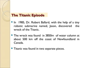
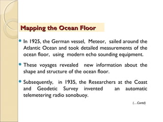
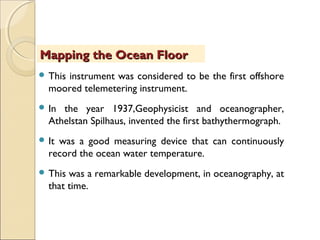
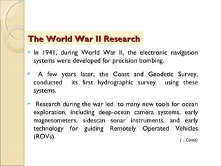
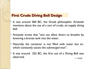
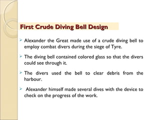
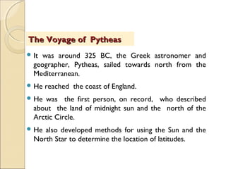
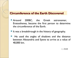
After attending this module, the user would be able to understand the history behind oceanographic explorations, the stages of development of oceanic navigations, and the scholars who have contributed at various stages. It will also be possible to comprehend the current trends in the science of oceanography in terms of on-going expeditions, technological improvements and the involvement made by various countries.
The study of physical oceanography helps in understanding all these aspects in detail. Let us see most of these factors and processes in our future modules. Mathematical models of all these processes are also developed using these phenomena and mechanisms. The individual aspects of all the elements of physical oceanography are to be studied in detail.
Oceans also contain a huge amount of mineral resources. Deep ocean basins are the zones of continuous sedimentation. The oceans are the final destination for many of all the sediments to be deposited. About 200 million years of earth history are available in the fossiliferous sediments deposited within the ocean basins. This module explains the characteristics of marine sediments.
This ppt will help to understand the concept of water mass in the world ocean. It gives an overview of it's origin, formation, distribution etc. in the world. It is also helpfull for Fisheries Science students.
A presentation to study the origin and development of oceanographic science in details from the ancient peoples to the modern period. This presentation will be very much helpful for the learners of this discipline.
Seas and Oceans are blue beauties of the planet earth.
Oceans are vast body of saline water occupying the great depressions on the earth. The surface beneath the oceanic waters is characterized by a lot of relief features.
The structure, configuration and relief features of the oceans also vary from each other.On the basis of Bathymetry and other studies, the morphology of Ocean basins contains a lot of relief features. This module highlights many of those features.
The reason for the occurrence of such a huge mass of water on the globe, is still a myth and reality. The reason goes back to the Origin of Earth itself. The exact mode of origin is not precisely known. Scientists assume, both Primary and secondary sources would have given rise to all both air and water on the earth. Two possible sources as internal source (or) external source have been proposed so far. Some of them are attributed towards the theories of origin of the earth.
A presentation to study the origin and development of oceanographic science in details from the ancient peoples to the modern period. This presentation will be very much helpful for the learners of this discipline.
China's global maritime expansion reaches Australia in 1400 A.D.Brura1
A global research agenda proving that China and the Arab maritime explorers and traders were well aware of latitude and longitude in mapping as far back as 1300 A.D. and had cross pollinated the world with many facets of Chinese innovation and research collecting.
E-content is a Comprehensive package of teaching material put into hypermedia format. Hypermedia is multimedia with internet deplorability. E-content can not be created by a teaching faculty alone . It needs the role of teacher, Video editor, production assistants, web developers (HTML 5 or Adobe captivate, etc). Analyze the learner needs and goals of the instructional material development, development of a delivery system and content, pilot study of the material developed, implementation, evaluating, refining the materials etc. In designing and development of E-content we have to adopt one of the instructional design models based on our requirements.
Pedagogy is the most commonly understood approach to teaching. It refers to the theory and practice of learning. Pedagogy is often described as the act of teaching. Pedagogy has little variations between traditional teaching and online teaching. Online teaching pedagogy is a method of effective teaching practice specifically developed for teaching via the internet. It has a set of prescribed methods, strategies, and practices for teaching academic subjects in an online (or blended) environment, where students are in a physical location separate from the faculty member.
Technology has changed the possibilities within teaching and learning. Classes, which prior to the digital era were restricted to lectures, talks, and physical objects, no longer have to be designed in that manner. Training in a synchronous virtual classroom can only be successful with the active participation and engagement of the learners. Explore the Virtual Classroom’s features and see how they can support and enhance your tutoring style.
• The monitoring and evaluation of the institutional processes require a carefully structured system of internal and external review. The NAAC expects the Institutions to undertake continuous Academic and Administrative Audits (AAA). This presentation is intended to serve as advisory to all accredited HEIs who volunteer to undertake AAA. The pros and cons of this process are also highlighted. Academic and Administrative Audit is the process of evaluating the efficiency and effectiveness of the administrative procedure. It includes assessment of policies, strategies & functions of the various administrative departments, control of the overall administrative system, etc. This checklist gives an overview what the audit committee members may look into while visiting an institution for this purpose. It invariably follows the Quality Indicators Framework prescribed by Accreditation Council in India.
• The monitoring and evaluation of the institutional processes require a carefully structured system of internal and external review. The NAAC expects the Institutions to undertake continuous Academic and Administrative Audits (AAA). This presentation is intended to serve as advisory to all accredited HEIs who volunteer to undertake AAA.
Chemical analysis data of water samples can not be used directly for understanding. They are to be used for various calculations in order to determine the quality parameters that have a lot of significances. A. Balasubramanian and D. Nagaraju, of the Department of Studies in Earth Science, Centre for Advanced Studies, University of Mysore, Mysore-570006, Karnataka, India have recently brought out a software and its application manual as a good book for reference and execution. The Name of the software is WATCHIT meaning Water Chemistry Interpretation Techniques. This software computes more than 100 parameters pertaining to water quality interpretations. The software follows its own method of approach to determine the required results. Systems International Units are used. Limited input parameters are required. This is suitable for all scientific research, government water quality data interpretations and for understanding the quality of water before using it.
Water conservation refers to reducing the usage of water and recycling of waste water for different purposes like domestic usage, industries, agriculture etc. This technical article highlights most of the popular methods of water conservation. A special note on rainwater harvesting is also provided.
This module gives an overview of general applications of current hydrogeological aspects. It is for the basic understanding of students and research scholars.
Climate Extreme (extreme weather or climate event) refers to the occurrence of a value of a weather or climate variable above (or below) a threshold value near the upper (or lower) ends of the range of observed values of the variable. Extreme weather and climate events, interacting with exposed and vulnerable human and natural systems, can lead to disasters.
WATER RESOURCES PLANNING AND MANAGEMENT POSSIBILITIES IN CHAMARAJANAGAR TALUK...Prof. A.Balasubramanian
Any unplanned development and utilization of water resources with result in water scarcity. In many parts of the developing world. Such a situation exists. In order to do proper planning and
management of water resources, it is necessary to conduct detailed analyses of the factors, which influence the water availability and its uses. In the present study, a comprehensive analysis have been undertaken for proper utilization of water resources in Chamarajanagar Taluk, which has been identified as one of the drought hit districts of Karnataka, in India. The factors analysed in this work are, surface and groundwater availability, land use, cropping pattern, recharge potential of soils and the rainfall pattern in typical areas of Taluk. It is observed that the problem of water scarcity is mainly due to the lack of irrigation planning and management. Hence, a
modified cropping pattern is suggested by taking into consideration of all available water resources and other conditions.
In broad terms, cultural geography examines the cultural values, practices, discursive and material expressions and artefacts of people, the cultural diversity and plurality of society.
It also emphasizes on how cultures are distributed over space, how places and identities are produced, how people make sense of places and build senses of place, and how people produce and communicate knowledge and meaning.
Minerals are formed by changes in chemical energy in systems which contain one fluid or vapor phase. In nature, minerals are formed by crystallisation or precipitation from concentrated solutions. These solutions are called as ore-bearing fluids. Ore-bearing fluids are characterised by high concentration of certain metallic or other elements.
Fluids are the most effective agents for the transport of material in the mantle and the Earth's crust.
Soils are complex mixers forming the skin of the earth's surface. Soil is a dynamic layer in which many complex chemical, physical and biological activities are going on constantly. Soils become adjusted to conditions of climate, landform and vegetation, and will change internally when those controlling conditions change. Soils are products of weathering. Soils play a dominant role in earth's geomorphic processes in a cyclic manner. The characteristics of soils are very essential for several reasons. This module highlights these characteristics.
GIS TECHNIQUES IN WATER RESOURCES PLANNING AND MANAGEMENT IN CHAMARAJANAGAR ...Prof. A.Balasubramanian
The over-exploitation and contamination of groundwater continue to threaten the long-term sustainability of our precious water resources, in spite of the best efforts made by various agencies.
This has many serious implications to the economic development of a country like India. Lack of
judicious planning and integration of environmental consideration to ground water development
projects are primarily responsible for such a state of affair in the ground water sector. Geographical Information Systems could be of immense help in planning sustainable ground water management strategies, especially in hard rock areas with limited ground water potential. Data collected from
Satellite Imagery and through field investigations have been integrated, on a GIS platform, for demarcation and prioritization of areas suitable for ground water development and ground water augmentation. An attempt has also been made to assess the vulnerability of the area to ground water
contamination. This paper demonstrates the utility of GIS in planning judicious management of ground water resources in a typical hard rock area of Chamarajanagar Taluk, Karnataka, state India.
Nanobiomaterials are very effective components for several biomedical and pharmaceutical studies. Among the metallic, organic, ceramic and polymeric nanomaterials, metallic nanomaterials have shown certain prominent biomedical applications. Enormous works have been done to synthesize, analyse and administer the metallic nanoparticles for various kinds of medical and therapeutic applications, during the last forty years. In these analyses, the prominent biomedical applications of ten metallic nanobiomaterials have been reviewed from various sources and works. It has been found that almost nine of them are used in a very wide spectrum of medical and theranostic applications.
A variety of Nano-biomaterials are synthesised, characterised and tested to find out their potentialities by global scientific communities, during the last three decades. Among those, nanostructured ceramics, cements and coatings are being considered for major use in orthopaedic, dental and other medical applications. The development of novel biocompatible ceramic materials with improved biomedical functions is at the forefront of health-related applications, all over the world. Understanding of the potential biomedical applications of ceramic nanomaterials will provide a major insight into the future developments. This study reviews and enlists the prominent potential biomedical applications of ceramic nanomaterials, like Calcium Phosphate (CaP), Tri-Calcium Phosphate (TCP), Hydroxy-Apatite(HAP), TCP+HAP, Si substituted HAP, Calcium Sulphate and Carbonate, Bioactive Glasses, Bioactive Glass Ceramics, Titania-Based Ceramics, Zirconia Ceramics, Alumina Ceramcis and Ceramic Polymer Composites.
The present forest and tree cover of the country is 78.37 million ha in 2007 which is 23.84% of the geographical areas and it includes 2.82% tree cover. This becomes 25.25%, if the areas above tree line i.e., 4000m are excluded from the total geographical area. The forest cover is classified into 3 canopy density classes.
1. Very Dense Forest (VDF) with canopy density more than 70%
2. Moderately Dense Forest (MDF) with Canopy density between 40-70% and
3. Open Forest (OF) with Canopy density between 10-40%
The increased availability of biomedical data, particularly in the public domain, offers the opportunity to better understand human health and to develop effective therapeutics for a wide range of unmet medical needs. However, data scientists remain stymied by the fact that data remain hard to find and to productively reuse because data and their metadata i) are wholly inaccessible, ii) are in non-standard or incompatible representations, iii) do not conform to community standards, and iv) have unclear or highly restricted terms and conditions that preclude legitimate reuse. These limitations require a rethink on data can be made machine and AI-ready - the key motivation behind the FAIR Guiding Principles. Concurrently, while recent efforts have explored the use of deep learning to fuse disparate data into predictive models for a wide range of biomedical applications, these models often fail even when the correct answer is already known, and fail to explain individual predictions in terms that data scientists can appreciate. These limitations suggest that new methods to produce practical artificial intelligence are still needed.
In this talk, I will discuss our work in (1) building an integrative knowledge infrastructure to prepare FAIR and "AI-ready" data and services along with (2) neurosymbolic AI methods to improve the quality of predictions and to generate plausible explanations. Attention is given to standards, platforms, and methods to wrangle knowledge into simple, but effective semantic and latent representations, and to make these available into standards-compliant and discoverable interfaces that can be used in model building, validation, and explanation. Our work, and those of others in the field, creates a baseline for building trustworthy and easy to deploy AI models in biomedicine.
Bio
Dr. Michel Dumontier is the Distinguished Professor of Data Science at Maastricht University, founder and executive director of the Institute of Data Science, and co-founder of the FAIR (Findable, Accessible, Interoperable and Reusable) data principles. His research explores socio-technological approaches for responsible discovery science, which includes collaborative multi-modal knowledge graphs, privacy-preserving distributed data mining, and AI methods for drug discovery and personalized medicine. His work is supported through the Dutch National Research Agenda, the Netherlands Organisation for Scientific Research, Horizon Europe, the European Open Science Cloud, the US National Institutes of Health, and a Marie-Curie Innovative Training Network. He is the editor-in-chief for the journal Data Science and is internationally recognized for his contributions in bioinformatics, biomedical informatics, and semantic technologies including ontologies and linked data.
Earliest Galaxies in the JADES Origins Field: Luminosity Function and Cosmic ...Sérgio Sacani
We characterize the earliest galaxy population in the JADES Origins Field (JOF), the deepest
imaging field observed with JWST. We make use of the ancillary Hubble optical images (5 filters
spanning 0.4−0.9µm) and novel JWST images with 14 filters spanning 0.8−5µm, including 7 mediumband filters, and reaching total exposure times of up to 46 hours per filter. We combine all our data
at > 2.3µm to construct an ultradeep image, reaching as deep as ≈ 31.4 AB mag in the stack and
30.3-31.0 AB mag (5σ, r = 0.1” circular aperture) in individual filters. We measure photometric
redshifts and use robust selection criteria to identify a sample of eight galaxy candidates at redshifts
z = 11.5 − 15. These objects show compact half-light radii of R1/2 ∼ 50 − 200pc, stellar masses of
M⋆ ∼ 107−108M⊙, and star-formation rates of SFR ∼ 0.1−1 M⊙ yr−1
. Our search finds no candidates
at 15 < z < 20, placing upper limits at these redshifts. We develop a forward modeling approach to
infer the properties of the evolving luminosity function without binning in redshift or luminosity that
marginalizes over the photometric redshift uncertainty of our candidate galaxies and incorporates the
impact of non-detections. We find a z = 12 luminosity function in good agreement with prior results,
and that the luminosity function normalization and UV luminosity density decline by a factor of ∼ 2.5
from z = 12 to z = 14. We discuss the possible implications of our results in the context of theoretical
models for evolution of the dark matter halo mass function.
Professional air quality monitoring systems provide immediate, on-site data for analysis, compliance, and decision-making.
Monitor common gases, weather parameters, particulates.
Richard's aventures in two entangled wonderlandsRichard Gill
Since the loophole-free Bell experiments of 2020 and the Nobel prizes in physics of 2022, critics of Bell's work have retreated to the fortress of super-determinism. Now, super-determinism is a derogatory word - it just means "determinism". Palmer, Hance and Hossenfelder argue that quantum mechanics and determinism are not incompatible, using a sophisticated mathematical construction based on a subtle thinning of allowed states and measurements in quantum mechanics, such that what is left appears to make Bell's argument fail, without altering the empirical predictions of quantum mechanics. I think however that it is a smoke screen, and the slogan "lost in math" comes to my mind. I will discuss some other recent disproofs of Bell's theorem using the language of causality based on causal graphs. Causal thinking is also central to law and justice. I will mention surprising connections to my work on serial killer nurse cases, in particular the Dutch case of Lucia de Berk and the current UK case of Lucy Letby.
Multi-source connectivity as the driver of solar wind variability in the heli...Sérgio Sacani
The ambient solar wind that flls the heliosphere originates from multiple
sources in the solar corona and is highly structured. It is often described
as high-speed, relatively homogeneous, plasma streams from coronal
holes and slow-speed, highly variable, streams whose source regions are
under debate. A key goal of ESA/NASA’s Solar Orbiter mission is to identify
solar wind sources and understand what drives the complexity seen in the
heliosphere. By combining magnetic feld modelling and spectroscopic
techniques with high-resolution observations and measurements, we show
that the solar wind variability detected in situ by Solar Orbiter in March
2022 is driven by spatio-temporal changes in the magnetic connectivity to
multiple sources in the solar atmosphere. The magnetic feld footpoints
connected to the spacecraft moved from the boundaries of a coronal hole
to one active region (12961) and then across to another region (12957). This
is refected in the in situ measurements, which show the transition from fast
to highly Alfvénic then to slow solar wind that is disrupted by the arrival of
a coronal mass ejection. Our results describe solar wind variability at 0.5 au
but are applicable to near-Earth observatories.
Observation of Io’s Resurfacing via Plume Deposition Using Ground-based Adapt...Sérgio Sacani
Since volcanic activity was first discovered on Io from Voyager images in 1979, changes
on Io’s surface have been monitored from both spacecraft and ground-based telescopes.
Here, we present the highest spatial resolution images of Io ever obtained from a groundbased telescope. These images, acquired by the SHARK-VIS instrument on the Large
Binocular Telescope, show evidence of a major resurfacing event on Io’s trailing hemisphere. When compared to the most recent spacecraft images, the SHARK-VIS images
show that a plume deposit from a powerful eruption at Pillan Patera has covered part
of the long-lived Pele plume deposit. Although this type of resurfacing event may be common on Io, few have been detected due to the rarity of spacecraft visits and the previously low spatial resolution available from Earth-based telescopes. The SHARK-VIS instrument ushers in a new era of high resolution imaging of Io’s surface using adaptive
optics at visible wavelengths.
Slide 1: Title Slide
Extrachromosomal Inheritance
Slide 2: Introduction to Extrachromosomal Inheritance
Definition: Extrachromosomal inheritance refers to the transmission of genetic material that is not found within the nucleus.
Key Components: Involves genes located in mitochondria, chloroplasts, and plasmids.
Slide 3: Mitochondrial Inheritance
Mitochondria: Organelles responsible for energy production.
Mitochondrial DNA (mtDNA): Circular DNA molecule found in mitochondria.
Inheritance Pattern: Maternally inherited, meaning it is passed from mothers to all their offspring.
Diseases: Examples include Leber’s hereditary optic neuropathy (LHON) and mitochondrial myopathy.
Slide 4: Chloroplast Inheritance
Chloroplasts: Organelles responsible for photosynthesis in plants.
Chloroplast DNA (cpDNA): Circular DNA molecule found in chloroplasts.
Inheritance Pattern: Often maternally inherited in most plants, but can vary in some species.
Examples: Variegation in plants, where leaf color patterns are determined by chloroplast DNA.
Slide 5: Plasmid Inheritance
Plasmids: Small, circular DNA molecules found in bacteria and some eukaryotes.
Features: Can carry antibiotic resistance genes and can be transferred between cells through processes like conjugation.
Significance: Important in biotechnology for gene cloning and genetic engineering.
Slide 6: Mechanisms of Extrachromosomal Inheritance
Non-Mendelian Patterns: Do not follow Mendel’s laws of inheritance.
Cytoplasmic Segregation: During cell division, organelles like mitochondria and chloroplasts are randomly distributed to daughter cells.
Heteroplasmy: Presence of more than one type of organellar genome within a cell, leading to variation in expression.
Slide 7: Examples of Extrachromosomal Inheritance
Four O’clock Plant (Mirabilis jalapa): Shows variegated leaves due to different cpDNA in leaf cells.
Petite Mutants in Yeast: Result from mutations in mitochondrial DNA affecting respiration.
Slide 8: Importance of Extrachromosomal Inheritance
Evolution: Provides insight into the evolution of eukaryotic cells.
Medicine: Understanding mitochondrial inheritance helps in diagnosing and treating mitochondrial diseases.
Agriculture: Chloroplast inheritance can be used in plant breeding and genetic modification.
Slide 9: Recent Research and Advances
Gene Editing: Techniques like CRISPR-Cas9 are being used to edit mitochondrial and chloroplast DNA.
Therapies: Development of mitochondrial replacement therapy (MRT) for preventing mitochondrial diseases.
Slide 10: Conclusion
Summary: Extrachromosomal inheritance involves the transmission of genetic material outside the nucleus and plays a crucial role in genetics, medicine, and biotechnology.
Future Directions: Continued research and technological advancements hold promise for new treatments and applications.
Slide 11: Questions and Discussion
Invite Audience: Open the floor for any questions or further discussion on the topic.
1. Topic of the lesson:
OCEANOGRAPHIC EXPLORATIONS
OceanographicOceanographic
ExplorationsExplorations
By
Prof.A. Balasubramanian
Centre for Advanced Studies in Earth Science
University of Mysore, India
3. After attending this module, the user would be able to
understand the history behind oceanographic
explorations, the stages of development of oceanic
investigations, and the scholars who have contributed at
various stages.
It will also be possible to comprehend the current trends
in the science of oceanography in terms of on-going
expeditions, technological improvements and the
involvement made by various countries.
ObjectivesObjectives
4. IntroductionIntroduction
Throughout the subject of world history, sailing has been
instrumental in the development of human civilization. Sailing
afforded the humanity with greater mobility than travel over
land. Sailing was done for trade, for transport, for warfare,
and for fishing. The earliest representation of a ship under
sail, appeared on a painted disc found in Kuwait, dating back
to the late 5th millennium BC. The first boats are presumed
to have been originated from dugout canoes, developed
independently by various stone age populations. These were
used for coastal fishing and travel.
(…Contd)
5. The earliest seaworthy boats might have been developed
as early as 45,000 years ago. Oceanographic explorations
and expeditions have been conducted by people for
several centuries. The birth of the oceanographic
navigation, dates back to several centuries. They all
contributed to the science of oceans.
Understanding the sequences of Oceanographic
explorations is a very lengthy aspect. A few of the notable
contributions made in the historical past are highlighted
in this lesson.
IntroductionIntroduction
6. Maritime history is the study of human activity at sea. It
covers a broad thematic element of history that often
uses a global approach, although national and regional
histories remain predominant.
As an academic subject, it often crosses the boundaries
of standard disciplines, focusing on understanding
humankind's various relationships to the oceans, seas,
and major waterways of the globe.
Maritime HistoryMaritime History
(…Contd)
7. The concepts of Nautical history records and interprets the
past events involving ships, shipping, navigation, and seafarers.
Many parts of their observations and understandings are taken
for scientific studies or subsequent explorations and
navigations.
Oceanographic explorations were started way back around
4000 BC.
The details available on various visible forms and oral-cum-
written records of sailors and explorers made the subject to
grow as a separate science.
Maritime HistoryMaritime History
8. It was during the period around 4500 BC, the Ocean
Diving habit was started by the ancient people.
This was the time when, coastal cultures like those seen
in Greece and China begun with people diving into the
sea to gather food and engage themselves in commerce.
In this period only, the ancient Egyptians developed their
first sailing vessels.
Ancient Explorations around 4000 BCAncient Explorations around 4000 BC
(…Contd)
9. These vessels were probably used for sailing in the
eastern Mediterranean sea and near the mouth of the
Nile river.
It was also recorded around 1000 BC, the Greek poet
Homer mentions about fishermen diving upto 30
meters by holding on to a heavy rock.
Ancient Explorations around 4000 BCAncient Explorations around 4000 BC
10. In search of tin and other natural resources, the
ancient Phoenicians develop typical sea routes
around the Mediterranean sea , into the Red Sea
and into the Indian Ocean.
They also reached England by sailing along the
western European coast.
First Sea Routes around 600 BCFirst Sea Routes around 600 BC
(…Contd)
11. Treasure Diving was continued throughout these
periods.
Diving for treasure created many wars between
the Persians and the Greeks.
Around 414 BC the Diving was used in warfare.
The Greek historian Thucydides writes about diving
used in warfare in his narration of the siege of
Syracuse.
First Sea Routes around 600 BCFirst Sea Routes around 600 BC
12. First Crude Diving Bell DesignFirst Crude Diving Bell Design
It was around 360 BC, the Greek philosopher Aristotle
mentions about the use of a sort of crude, air-supply diving
bell.
Aristotle wrote that "one can allow divers to breathe by
lowering a bronze tank into the water.
Naturally the container is not filled with water but air,
which constantly assists the submerged man".
It was around 325 BC, the first use of a Diving Bell was
observed. (…Contd)
13. Alexander the Great made use of a crude diving bell to
employ combat divers during the siege of Tyre.
The diving bell contained colored glass so that the divers
could see through it.
The divers used the bell to clear debris from the
harbour.
Alexander himself made several dives with the device to
check on the progress of the work.
First Crude Diving Bell DesignFirst Crude Diving Bell Design
14. It was around 325 BC, the Greek astronomer and
geographer, Pytheas, sailed towards north from the
Mediterranean.
He reached the coast of England.
He was the first person, on record, who described
about the land of midnight sun and the north of the
Arctic Circle.
He also developed methods for using the Sun and the
North Star to determine the location of latitudes.
The Voyage of PytheasThe Voyage of Pytheas
15. Around 200BC, the Greek astronomer,
Eratosthenes, became the first person to determine
the circumference of the Earth.
It was a breakthrough in the history of geography.
He used the angles of shadows and the distance
between Alexandria and Syene to arrive at a value of
40,000 km.
Circumference of the Earth DiscoveredCircumference of the Earth Discovered
(…Contd)
16. The actual circumference of the Earth was found to
be 40,032 km.
The world’s all geographic, earth and atmospheric
sciences got a turning point after these observations.
Circumference of the Earth DiscoveredCircumference of the Earth Discovered
17. In the year 150 BC, the Greek astronomer and
geographer, Ptolemy, produced the first map of the
ancient world.
It was showing the distribution of continents of Europe,
Asia, and Africa as well as the surrounding oceans.
This early map was one of the first known maps
developed to include the lines of latitude and longitude.
Ptolemy's Map of the WorldPtolemy's Map of the World
(…Contd)
18. Around the year 100 BC, Salvage diving operations were
continued around the major shipping ports of the eastern
Mediterranean.
It was around 200 AD, the First Indicated Use of Goggles
were found from the artworks on Peruvian pottery.
They have shown the divers wearing goggles and
holding the fish with them.
Fishery was an important occupation of people from time
immemorial.
Ptolemy's Map of the WorldPtolemy's Map of the World
19. It was around 900 AD, the Vikings begun to explore and
colonize the Iceland, Greenland, and Newfoundland.
They were among the first groups to use the North Star
to determine their latitude.
In the year 1002, Norse explorer Leif Erikson became
the first European to land in the North America.
Viking Expeditions and Voyage of Leif EriksonViking Expeditions and Voyage of Leif Erikson
(…Contd)
20. His voyage took place almost 500 years before that of
the Christopher Columbus.
He called the new land as Vinland and established a
Norse settlement in what is now seen in the northern
tip of Newfoundland in Canada.
This paved the way for oceanographic explorations for
territorial ownership, at a later stage.
Viking Expeditions and Voyage of Leif EriksonViking Expeditions and Voyage of Leif Erikson
21. Chinese exploration includes exploratory Chinese
travels abroad, on land and by sea, from the 2nd
century BC until the 15th century.
Before the advent of the Chinese-invented mariner's
compass in the 11th century, the seasonal monsoon
winds controlled Chinese navigation.
ChineseChinese ExplorationExploration
(…Contd)
22. In the year 1405, the Chinese made seven voyages
consisting of over 300 ships with a combined crew of
nearly 37,000.
These voyages were designed to extend the Chinese
influence and impress their neighboring states.
Their economic pressures back home made them to
put an end to these expensive voyages of the
Chinese.
ChineseChinese ExplorationExploration
23. Chinese envoys sailed into the Indian Ocean in the
late 2nd century BC.
They reportedly reached Kanchipuram, known as
Huangzhi to them.
During the late 4th and early 5th centuries, Chinese
pilgrims like Faxian, Zhiyan, and Tanwujie, began
travelling by sea to India, bringing back Buddhist
scriptures and sutras to China.
Indian Ocean and beyondIndian Ocean and beyond
(…Contd)
24. By the 7th century, as many as 31 recorded Chinese
monks including I Ching managed to reach India the
same way.
In 674, the private explorer, Daxi Hongtong, was
among the first to end his journey at the southern
tip of the Arabian Peninsula, after travelling through
36 countries west of the South China Sea.
Indian Ocean and beyondIndian Ocean and beyond
(…Contd)
25. Chinese seafaring merchants and diplomats of the
medieval Tang Dynasty (618—907) and Song Dynasty
(960—1279) often sailed into the Indian Ocean after
visiting ports in South East Asia.
Chinese sailors would travel to Malaya, India, Sri Lanka,
into the Persian Gulf.
Indian Ocean and beyondIndian Ocean and beyond
26. The Spanish explorer Christopher Columbus sets out
on his historic voyage across the Atlantic Ocean in
search of a passage to China and India, in the year 1492.
Instead, he discovered the North and South America,
which eventually led to the establishment of European
colonization in these newly discovered continents.
Voyages of Columbus and Vasco da GamaVoyages of Columbus and Vasco da Gama
(…Contd)
27. Similarly, in the year 1498, they Voyage of Vasco da
Gama made some unique findings.
The Portuguese explorer, Vasco da Gama, sailed
his ships around the Cape of Good Hope, located on
the southern tip of Africa.
(…Contd)
Voyages of Columbus and Vasco da GamaVoyages of Columbus and Vasco da Gama
28. He became the first European to reach India by
boat.
The expedition later returned to Portugal with a
huge valuable cargo of rare spices and valuables.
This has opened a new dimension in oceanographic
explorations.
Voyages of Columbus and Vasco da GamaVoyages of Columbus and Vasco da Gama
29. In the year 1519, Ferdinand Magellan and his fleet
departed from Portugal to start a daring voyage of
discovery, in history.
The fleet became the first to sail around the whole
world.
Magellan's expedition of 1519–1522 became the first
expedition to sail from the Atlantic Ocean into the
Pacific Ocean.
First Circumnavigation of the WorldFirst Circumnavigation of the World
(…Contd)
30. The Magellanic Penguin was named after him, as he
was the first European to note it.
In March 1505, at the age of 25, Magellan enlisted in
the fleet of 22 ships sent to host D. Francisco de
Almeida as the first viceroy of Portuguese India.
Although his name does not appear in the chronicles,
it is known that he remained there eight years,
in Goa, Cochin and Quilon.
First Circumnavigation of the WorldFirst Circumnavigation of the World
(…Contd)
31. He participated in several battles, including the battle of
Cannanore in 1506, where he was wounded.
In 1509 he fought in the battle of Diu.
But unfortunately, Magellan could not live to see the
entire accomplishment.
He died on the Island of Mactan in the Philippines, in
1521, from the poison arrows sent by the local natives.
First Circumnavigation of the WorldFirst Circumnavigation of the World
32. An English mathematician, named William Bourne,
drew up the first known plans for an underwater
boat, in the year 1578.
These plans called for a leather-covered wooden
frame craft that would be rowed from the inside.
Later, in the year 1620, the First Submarine was
made.
Dutch physician, Cornelis Drebbel, built the
world's first submarine.
First Plans for a SubmarineFirst Plans for a Submarine
(…Contd)
33. The boat was made of wood reinforced with iron and
covered with leather.
It was a 12 seater submarine in two rows inside.
They rowed with oars that stick out the sides through
tight fitting leather sleeves to keep the water out.
Drebbel made several trips in his submarine in the
Thames River, near London , at a depth of about 4 to 5
meters.
First Plans for a SubmarineFirst Plans for a Submarine
34. In 1690, the first Air-replenished Diving Bell was
made.
The English astronomer, Edmund Halley, developed
a diving bell in which the atmosphere in the bell can
be replenished by sending weighted barrels of air
down from the surface.
Voyage of Edmund HalleyVoyage of Edmund Halley
(…Contd)
35. In 1698, Edmund Halley made what was called as
the first scientific voyage to study the variation of
the magnetic compass.
During his voyages, he also made very important
contributions to the understanding of the trade
winds.
Voyage of Edmund HalleyVoyage of Edmund Halley
36. In the year 1715, the First Waterproof Suit was
made.
Chevalier de Beauve, a guard in the French Navy,
developed a waterproof suit with lead shoes.
Air gets supplied from the surface by two leather
tubes fastened to the helmet.
Waterproof Suit and Diving DevicesWaterproof Suit and Diving Devices
(…Contd)
37. In 1715, the First Enclosed Diving Device was made.
It was Englishman John Lethbridge who developed a
completely enclosed, one-man diving dress.
The device was made from a reinforced, leather-
covered barrel of air, equipped with a glass porthole
for viewing, and two arm holes with watertight
sleeves.
Waterproof Suit and Diving DevicesWaterproof Suit and Diving Devices
38. It was in 1768, Lieutenant James Cook, left the port
of Plymouth, England on a voyage to observe a transit
of the planet of Venus across the Sun.
During this and other two voyages, he could explore
and map the Pacific Ocean.
He was the first person to use a chronometer to
accurately determine his longitude at sea surface.
The First Voyage of EndeavourThe First Voyage of Endeavour
(…Contd)
39. In the year 1785, the American patriot and inventor,
Benjamin Franklin, writes a lengthy letter to a scientific
colleague in France.
Known as his Sundry Maritime Observations, the letter
announces the discovery of the Gulf Stream and
touches on a wide range of maritime subjects such as
ship propulsion methods, hull design, and causes of
disasters at sea.
The First Voyage of EndeavourThe First Voyage of Endeavour
40. In the year 1800, Robert Fulton, the inventor of the
steamboat, built an early submarine called The Nautilus.
This cigar-shaped craft was made of wood over iron plates,
and used a horizontal rudder to control the up-and-down
movement of the submarine.
This system is still in use even today.
President Thomas Jefferson signs a law establishing the
United States Coast Survey, in 1807.
The NautilusThe Nautilus
41. In the year 1831, the English naturalist, Charles Darwin,
departed England aboard in the H.M.S. Beagle.
The goal of the expedition was to perform a survey of
Patagonia and Tierra del Fuego. Darwin studied the
plants and animals at each new stop.
He discovered many unique species on the Galapagos
Islands off the coast of Peru in South America.
The Voyage of the H.M.S. BeagleThe Voyage of the H.M.S. Beagle
(…Contd)
42. These discoveries led to his groundbreaking theory
of evolution.
In his book, The Origin of Species, Darwin suggested
that the deep ocean may be a sanctuary for living
fossils.
In the year 1840, the first Modern Sounding was
done.
The Voyage of the H.M.S. BeagleThe Voyage of the H.M.S. Beagle
(…Contd)
43. Sir James Clark Ross conducted the first open ocean
deep-water sounding in 2425 fathoms in the south
Atlantic ocean at Latitude 27 S Longitude 17 W.
The sounding was made using the traditional method
of lowering a hemp rope over the side of the ship.
The Voyage of the H.M.S. BeagleThe Voyage of the H.M.S. Beagle
44. In 1842, Charles Darwin publishes The Structure and
Distribution of Coral Reefs.
In the year 1843, British naturalist Edward Forbes
stated about his belief that the life cannot exist below
300 fathoms (1800 feet) in the deep sea.
This declaration made a 20-year debate about the
possible existence of a lifeless zone in the ocean known
as an azoic zone.
Observations of early 19Observations of early 19thth
centurycentury
(…Contd)
45. In the year 1849, Coast Survey soundings in support
of Gulf Stream investigations resulted in the
discovery of the continental shelf break and the
continental slope.
In 1853, Louis F. de Pourtales of the U.S. Coast
Survey found indications of life in depths over 1000
fathoms (6000 feet), inside the deep sea.
(…Contd)
Observations of early 19Observations of early 19thth
centurycentury
46. In 1857, the first Deep Sea Canyon was discovered by
James Alden, a commanding officer of the Coast Survey
Steamer Active, in the center of the Monterey Bay, off
the coast of California.
It is, now, known as the Monterey Canyon.
In 1860, the first Chart of the Gulf Stream was published
by the U.S. Coast Survey.
In 1861, the first U.S. Navy Submarine, Known as the
Alligator, was designed and used.
Observations of early 19Observations of early 19thth
centurycentury
47. In 1872, the most popular Voyage of the H.M.S.
Challenger happened.
The H.M.S. Challenger sailed from Portsmouth, England
and begun its four-year trip around the world.
During the voyage, scientists tested the salinity,
temperature and density of the seawater.
Information was also collected about the ocean
currents, sediment, and meteorology.
Observations of the late 19Observations of the late 19thth
centurycentury
(…Contd)
48. The crew discovered underwater mountain chains
and hundreds of species previously unknown.
This research was eventually consolidated into a fifty-
volume research report known as The Challenger
Report.
This research formed the basis of modern
oceanography.
Observations of the late 19Observations of the late 19thth
centurycentury
49. In 1874, the Sigsbee Sounding Machine was invented. This
new machine became the basic model for wireline sounding
in the deep sea for about 50 years.
In 1882, the first Oceanographic Research Vessel,
Albatross, was sailed.
In 1888, the first Modern Electric Submarine, Gymnote,
was designed by the French Navy. This steel-hulled craft
was powered by a 204-cell battery.
Other developmentsOther developments
(…Contd)
50. The Marine Survey of the Pacific, made in 1899, by the
Swiss Zoologist Alexander Agassiz , was yet another
milestone.
In 1912, the Scripps Institute of Oceanography became
affiliated with the University of California.
The Scripps is one of the world's leading marine research
centers, today.
In 1914, the first Acoustic Exploration of the Sea Floor was
attempted by the Canadian inventor Reginald Fessenden.
Other developmentsOther developments
51. On the 15th
April 1912, the White Star Liner, Titanic,
sunk after striking an iceberg in the North Atlantic
Ocean.
Over 1500 passengers lost their lives during one of
the worst peacetime maritime disasters in the history
of mankind.
This tragedy led to a concerted effort to devise an
acoustic means of discovering the objects in the under
water zone, well ahead of a moving vessel.
The Titanic EpisodeThe Titanic Episode
(…Contd)
52. In 1985, Dr. Robert Ballard, with the help of a tiny
robotic submarine named, Jason, discovered the
wreck of the Titanic.
The wreck was found in 3850m of water column at
about 500 km off the coast of Newfoundland in
Canada.
Titanic was found in two separate pieces.
The Titanic EpisodeThe Titanic Episode
53. In 1925, the German vessel, Meteor, sailed around the
Atlantic Ocean and took detailed measurements of the
ocean floor, using modern echo sounding equipment.
These voyages revealed new information about the
shape and structure of the ocean floor.
Subsequently, in 1935, the Researchers at the Coast
and Geodetic Survey invented an automatic
telemetering radio sonobuoy.
Mapping the Ocean FloorMapping the Ocean Floor
(…Contd)
54. This instrument was considered to be the first offshore
moored telemetering instrument.
In the year 1937,Geophysicist and oceanographer,
Athelstan Spilhaus, invented the first bathythermograph.
It was a good measuring device that can continuously
record the ocean water temperature.
This was a remarkable development, in oceanography, at
that time.
Mapping the Ocean FloorMapping the Ocean Floor
55. In 1941, during World War II, the electronic navigation
systems were developed for precision bombing.
A few years later, the Coast and Geodetic Survey,
conducted its first hydrographic survey using these
systems.
Research during the war led to many new tools for ocean
exploration, including deep-ocean camera systems, early
magnetometers, sidescan sonar instruments, and early
technology for guiding Remotely Operated Vehicles
(ROVs).
The World War II ResearchThe World War II Research
(…Contd)
56. This was a turning point in all modern oceanographic
explorations.
In 1943, the Aqua-Lung, the first modern scuba system
was designed.
In 1951, the British ship, Challenger II, bounced the
sound waves off the ocean bottom and located the
sea's deepest point.
It was subsequently named as the Challenger Deep.
The World War II ResearchThe World War II Research
57. It was in 1953, the American geologist, Marie Tharp,
studied the sounding profiles from the Atlantic Ocean
and discovered a rift valley.
Later studies revealed that it is a continuous rift
valley extending over 40,000 nautical miles along the
ocean floor.
This discovery provided the most useful evidences for
the newly formed theory of continental drift, known
today as plate tectonics.
Discovery of Mid-Atlantic RidgeDiscovery of Mid-Atlantic Ridge
(…Contd)
58. Later in 1961, the Scripps Institution of Oceanography
developed the Deep Tow System.
This sonar system became the forerunner of all
remotely-operated and unmanned oceanographic
systems, which is used even today.
In 1963, the first operational multi-beam sounding
system was installed on the USNS Compass Island.
Discovery of Mid-Atlantic RidgeDiscovery of Mid-Atlantic Ridge
59. Alvin, a new deep submergence vehicle, was constructed in
1964-by the Woods Hole Oceanographic Institute.
It was the first U.S. deep diving submersible and the first deep-
sea submersible capable of carrying passengers.
In 1965, the first Underwater Robotic submarine, Halibut,
which can lower miles of lengths of its cables bearing lights,
cameras, and other gear to spy on enemy armaments and find
the other materials that were once lost on the bottom of the
sea.
Robotic SubmersiblesRobotic Submersibles
60. In 1968, the deep sea research vessel, Glomar
Challenger, departed on a 15 year expedition
known as the Deep Sea Drilling Program.
The ship criss-crossed the entire Mid-Atlantic
Ridge between Africa and South America and took a
lot of core samples.
Deep Sea Drilling ProgramDeep Sea Drilling Program
(…Contd)
61. The ages of the samples provided solid evidences
for the theory of seafloor spreading, which late gave
rise to the modern theory of plate tectonics.
In 1969, the first Long Duration Submersible
Expedition was made off the coast of Palm Beach,
Florida.
Hydrothermal Vents were discovered in 1977.
Deep Sea Drilling ProgramDeep Sea Drilling Program
62. In 1977, the deep-sea submersible, Alvin, was sent to
explore a part of the mid-ocean ridge north of the
Galápagos Islands known as the Galápagos Rift.
Alvin was following in the tracks of an unmanned vehicle,
towed by the research vessel Knorr, that had detected
unusually high bottom-water temperatures and had
taken photographs of odd white objects among the
underwater lava flows—tantalizing clues about curious,
possibly biological features.
Deep -sea submersible-Deep -sea submersible-AlvinAlvin
63. In 1990, a program known as, Argo, was started by
deploying 3,000 robotic probes throughout the world's
oceans to monitor the climate, weather, and sea surface
height.
It was named after the mythical ship from the story of
Jason and the Argonauts. The last probes were
successfully placed in 2007.
In 1993, the undersea Laboratory, Aquarius, began its
operation off the coast of Key Largo, Florida.
Argo ProjectArgo Project
64. The worldwide mapping of the sea floor from space
was done in 1995.
In 2010, the Census of Marine Life was Completed.
This 10 year project involved 2,700 scientists from 80
nations.
The census revealed what, where, and how much
lives and hides were there in the global oceans.
Seafloor Mapping from SpaceSeafloor Mapping from Space
(…Contd)
65. The data is made available in the online directory
that allows anyone to map the global addresses of
species, today.
In 2012, a Japanese expedition and film crew
captured the first video of a giant live giant squid in
its natural environment.
Seafloor Mapping from SpaceSeafloor Mapping from Space
66. Citizens, sailors, and scientists have observed the seas and
oceans for several hundred years
First from the shore, then from ships and submersibles, and
recently from satellites.
While carrying out these explorations, scientists and
engineers learned that they could sometimes leave some
sophisticated instruments in the ocean, secured by wires,
buoys, weights, and floats and allow them to systematically
map the ocean floors.
Modern trends in OceanographyModern trends in Oceanography
(…Contd)
67. This method is known as the moored observatory.
This approach has advanced the understanding of the
oceans and their interaction with the Earth and the
atmosphere.
Modern trends in OceanographyModern trends in Oceanography
68. In order to understand the ocean, scientists often find that they
have to get themselves or their instruments into very specific
parts of it.
Traditionally, researchers have used ships to photograph the
depths.
They used to drop floats and drifters into the currents, and to
collect samples of water, rock, and marine life, for their analysis.
In recent years, the spectrum of available observing tools has
grown to include human-occupied submersibles, remote-
controlled vehicles, autonomous, and towed robots.
Underwater VehiclesUnderwater Vehicles
69. In the year 1957, the Soviet Union successfully
launched its satellite, Sputnik I.
It was the world's first artificial satellite.
About the size of a basketball, and weighing only 183
lbs, Sputnik took about 98 minutes to orbit the Earth.
Earth's first Artificial SatelliteEarth's first Artificial Satellite
(…Contd)
70. This was the Earth's first artificial satellite ushered in
an age of exploration, not only of space, but of the
Earth's land masses and oceans as well.
Satellites that detect and observe different
characteristics and features of the Earth's
atmosphere, lands, and oceans are often referred to
as environmental satellites.
Earth's first Artificial SatelliteEarth's first Artificial Satellite
71. POES (Polar Operational Environmental Satellites)
maintain an orbital height of about 500 miles(900km)
and take about 100 min to complete an orbit.
Sea surface-temperature is one important type of
data that these satellites provide.
Knowing the temperature of ocean water is an
important aspect in oceanography.
Polar Operational Environmental SatellitesPolar Operational Environmental Satellites
(…Contd)
72. Temperature changes influence the behaviour of fish.
It can cause the bleaching of corals, and affects the
weather all along the coast.
Satellite images of sea-surface temperature also show
patterns of water circulation.
Polar Operational Environmental SatellitesPolar Operational Environmental Satellites
73. In addition to temperature, satellites also provide
information about the color of the ocean.
This allows scientists to detect the presence of algal
blooms, river plumes, and other events.
Satellite imagery is also being used to map features in
the water, such as coral reefs.
Sensors such as Landsat-7 and IKONOS provide
detailed information on local areas.
Mapping ocean surface indicatorsMapping ocean surface indicators
(…Contd)
74. LANDSAT-7 is part of the LANDSAT program, one of the
longest existing environmental satellite programs.
Satellites providing environmental imagery are used jointly
with other organizations that receive data from various
sensors.
For example, marine animals, such as sea turtles and manatees,
can be fitted with transmitters that relay information about
their location.
Satellites are becoming a standard tool for studying the oceans.
Mapping ocean surface indicatorsMapping ocean surface indicators
75. The purpose of the Sea-viewing Wide Field-of-view Sensor
(SeaWiFS) Project is to provide quantitative data on global ocean
bio-optical properties to the Earth science community.
Subtle changes in ocean color signify various types and quantities
of marine phytoplankton (microscopic marine plants), the
knowledge of which has both scientific and practical applications.
The SeaWiFS Project will develop and operate a research data
system that will process, calibrate, validate, archive and distribute
data received from an Earth-orbiting ocean color sensor.
Background of the SeaWiFS ProjectBackground of the SeaWiFS Project
76. The concentration of microscopic marine plants, called
phytoplankton, can be derived from satellite observation
and quantification of ocean color.
This is due to the fact that the color in most of the
world's oceans in the visible light region, (wavelengths of
400-700 nm) varies with the concentration of chlorophyll
and other plant pigments present in the water, i.e., the
more phytoplankton present, the greater the
concentration of plant pigments and the greener the
water.
Ocean Color Reflecting Marine BiotaOcean Color Reflecting Marine Biota
(…Contd)
77. Since an orbiting sensor can view every square
kilometer of cloud-free ocean every 48 hours, satellite-
acquired ocean color data constitute a valuable tool for
determining the abundance of ocean biota on a global
scale and can be used to assess the ocean's role in the
global carbon cycle and the exchange of other critical
elements and gases between the atmosphere and the
ocean.
Ocean Color Reflecting Marine BiotaOcean Color Reflecting Marine Biota
78. GOES satellites provide the kind of continuous monitoring
necessary for intensive data analysis.
Because GOES satellites stay above a fixed spot on the
surface, they provide a constant vigil for the atmospheric
"triggers" for severe weather conditions such as tornadoes,
flash floods, hail storms, and hurricanes.
When these conditions develop the GOES satellites are able
to monitor storm development and track their movements.
Geostationary Operational Environmental Satellites (GOES)
(…Contd)
79. GOES satellite imagery is also used to estimate rainfall
during the thunderstorms and hurricanes for flash flood
warnings, as well as estimates snowfall accumulations and
overall extent of snow cover.
Such data help meteorologists issue winter storm
warnings and spring snow melt advisories. Satellite
sensors also detect ice fields and map the movements of
sea and lake ice.
Geostationary Operational Environmental Satellites (GOES)
80. The LANDSAT Program provides the longest
continuous space-based record of Earth’s land in
existence.
Since 1972, LANDSAT satellites have collected
measurements of Earth’s continents and surrounding
coastal regions that have enabled people to study
forests, food production, water and land use,
ecosystems, geology, and more.
The Landsat ProgramThe Landsat Program
(…Contd)
81. The long data record allows scientists to evaluate the
dynamic changes caused by both natural processes and
human practices.
The LANDSAT Program is jointly managed by the U.S.
Geological Survey and NASA.
Every day, LANDSAT satellites provide essential
information for land managers and policy makers to
support wise decisions about our resources and
environment in the places we live and work.
The Landsat ProgramThe Landsat Program
82. The large ocean ecosystems are called as biogeographic
provinces.
Biogeographic provinces provide useful categories for
comparing and contrasting important ocean processes
such as primary production, carbon flux, and species
distribution and diversity.
Climatological provinces have been identified using a
priori expert knowledge.
Global Ocean BiomesGlobal Ocean Biomes
(…Contd)
83. The global remote sensing data automatically produce the
time and space resolved province distributions.
Today, 3D mapping of ocean water masses and biomes are
being done in oceanographic analysis.
Satellite oceanographic products provide an unequalled view
of the global ocean surface allowing us the opportunity to map
important biogeochemical processes in the ocean such as
primary production and carbon export to the deep ocean.
Global Ocean BiomesGlobal Ocean Biomes
84. At least 20,000 new biochemical substances from
marine plants and animals have been identified during
the past 30 years, many with unique properties useful
in fighting disease.
“Biodiscovery” researchers have had success in all
types of ocean environments.
Ocean Exploration and Human HealthOcean Exploration and Human Health
(…Contd)
85. A 1991 expedition by the Scripps Institution of
Oceanography’s Paul Jensen and William Fenical resulted in
the discovery of a new marine bacterium, Salinispora tropica,
found in the shallow waters off the Bahamas.
This bacterium produces compounds that are being
developed as anticancer agents and antibiotics.
It is related to the land-based Streptomyces genus, the source
of more than half of our current suite of antibiotics.
Ocean Exploration and Human HealthOcean Exploration and Human Health
86. Researchers are now looking at the ocean through a new lens:
the science of ”Metagenomics.”
In the ocean, as on land, thousands of species of tiny microbes
play a key role in nutrient cycles, including the carbon cycle,
and in maintaining Earth’s atmosphere, among other important
functions.
Metagenomics enables researchers to quickly sequence the
DNA of all microbes in a given sample, in this case seawater,
revealing how microbes function and how they may work in
different environments.
““Metagenomics”Metagenomics”
(…Contd)
87. After mapping 64 million base pairs (units of DNA),
thousands of new genes and also variations in the
genetic composition of microbes at different depths
were also discovered.
Genomes from organisms in the deep ocean had many
“jumping genes,” or pieces of DNA that can move from
one part of the genome to another.
““Metagenomics”Metagenomics”
88. Two other U.S. academic and research organizations
operate human-occupied submersibles: the University
of Hawaii has two Pisces submersibles capable of diving
to 2,000 meters (1.2 miles), and Harbor Branch
Oceanographic Institution in Florida has two Johnson
Sea-Link submersibles that can dive to approximately
1,000 meters (0.6 miles).
Human-Occupied SubmersiblesHuman-Occupied Submersibles
(…Contd)
89. France and Russia operate HOVs that can dive to a
depth of 6,000 meters (3.7 miles), and Japan’s
Shinkai 6500 is able to dive down 6,500 meters (4.0
miles).
China is building an HOV that will be able to dive to
7,000 meters (4.3 miles).
Human-Occupied SubmersiblesHuman-Occupied Submersibles
90. The Autonomous Benthic Explorer, more commonly
known as ABE, is the first underwater robotic vehicle of
its kind.
ABE was designed and built at the Woods Hole
Oceanographic Institution (WHOI) in the mid 1990’s.
ABE weights approximately 1200 pounds and is a little
over 2 meters long.
ABE's top cruising speed is 2 knots.
Autonomous Benthic ExplorerAutonomous Benthic Explorer
(…Contd)
91. As an Autonomous Underwater Vehicle (AUV), ABE
is a true robot, able to move on its own without a
pilot or tether to either ship or submersible.
This gives ABE the advantage of covering large areas
of underwater terrain.
ABE was invented to address scientists' frequent need
to monitor underwater areas over long periods of
time.
Autonomous Benthic ExplorerAutonomous Benthic Explorer
(…Contd)
92. ABE is designed to perform a predetermined set of
maneuvers, take photographs, and collect data and
samples within an area about the size of a city block.
After accomplishing its mission, ABE “goes to sleep,”
conserving its power supply for months at a time,
allowing for future missions without recharging its
batteries.
Autonomous Benthic ExplorerAutonomous Benthic Explorer
93. Although ships have been crisscrossing the ocean for
centuries, Earth observations from satellites provided the
first truly global view of the ocean and its processes.
Recent improvements in satellite communications on ships
are fundamentally changing the nature of sea-going science.
Many oceanographic ships now have Internet connections
through a network known as HiSeasNet.
With this network, shipboard scientists can work in real
time with their land-based colleagues.
Satellite CommunicationsSatellite Communications
94. The International Indian Ocean Expedition (IIOE) resulted
from a cascade of effects.
The International Geophysical Year of 1957-1958 had
shown the value of coordinated multinational efforts in
ocean science.
This realization resulted in the International Council of
Scientific Unions (now the International Council for
Science) creating the Scientific Committee on Oceanic
Research (SCOR) to continue to stimulate international
cooperation in ocean sciences.
International Indian Ocean Expedition (IIOE)International Indian Ocean Expedition (IIOE)
(…Contd)
95. The International Indian Ocean Expedition (IIOE) was
one of the greatest international, interdisciplinary
oceanographic research efforts.
It involved forty-six research vessels (under fourteen
different flags) that carried out an unprecedented
number of hydrographic surveys (and repeat surveys)
of the entire Indian Ocean basin from 1960 – 1965.
International Indian Ocean Expedition (IIOE)International Indian Ocean Expedition (IIOE)
96. In the last 50 years, since the formation of IIOE, there
have been two fundamental developments in ocean
science.
The first one is the emergence of new components of
the ocean observing system - most notably remote
sensing and Argo floats.
Emergence of InnovationsEmergence of Innovations
(…Contd)
97. The second one is the emergence of ocean modelling
in all its facets - including short-term forecasting,
seasonal predictions and climate projections.
These developments have revolutionised our
understanding of the global oceans.
Ocean exploration continues to illuminate details
about Earth processes.
Emergence of InnovationsEmergence of Innovations
98. Space-borne radar altimeters are superb tools for
mapping the ocean-surface topography, the hills and
valleys of the sea surface.
These instruments send a microwave pulse to the
ocean’s surface and determine the time taken by the
waves to return.
A microwave radiometer corrects any delay that may be
caused by water vapor in the atmosphere.
Ocean altimetryOcean altimetry
(…Contd)
99. Combining these data with the precise location of the
spacecraft makes it possible to determine the sea-surface
height very accurately.
The strength and shape of the returning signal also
provides information on the wind speed and height of
ocean waves.
These data are used in ocean models to calculate the
speed and direction of ocean currents and the amount and
location of heat stored in the ocean, which, in turn,
reveals the global climatic variations.
Ocean altimetryOcean altimetry
100. The Ocean Surface Topography Mission (OSTM) on
the Jason-2 satellite is an international Earth
observation satellite mission that continues the
measurement of sea surface height, which was started
in the year 1992.
It was followed by the NASA/CNES Jason-1 mission
launched in the year 2001.
Ocean Surface Topography MissionOcean Surface Topography Mission
(…Contd)
101. The two previous altimetry missions, TOPEX/Poseidon and
Jason-1, have led to major advances in the science of physical
oceanography and in climate studies.
Their 15-year record of ocean surface topographic data has
provided the first opportunity to observe and understand the
global change of ocean circulation and sea level.
The results have improved the understanding of the role of
the ocean in climate change and improved both weather and
climate predictions.
Ocean Surface Topography MissionOcean Surface Topography Mission
102. Oceanographic exploration and Maritime history are the two
broad overarching subjects. They include the aspects like fishing,
whaling, international maritime law, naval history, the history of
ships, ship design, shipbuilding, the history of navigation, the
history of the various maritime-related sciences (oceanography,
cartography, hydrography, etc.), sea exploration, maritime
economics and trade, shipping, yachting, seaside resorts, the
history of lighthouses and aids to navigation, maritime themes in
literature, maritime themes in art, the social history of sailors
and passengers and sea-related communities.
ConclusionConclusion
(…Contd)
103. Jacques Yves Cousteau, an Oceanographer said “The future
is in the hands of those who explore... and from all the
beauty they discover while crossing perpetually receding
frontiers, they develop for nature and for humankind an
infinite love."
Oceanographic explorations continue even today in the
form of underwater surveys, expeditions and mission for
sustainable development.
ConclusionConclusion