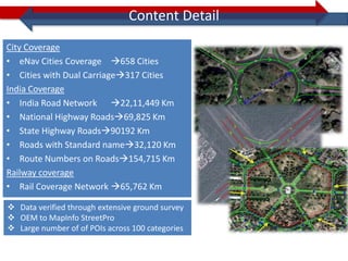
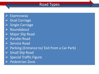
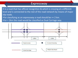
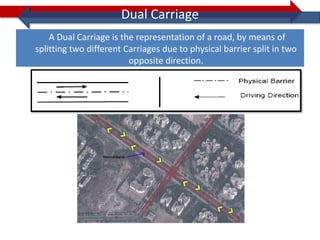
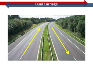
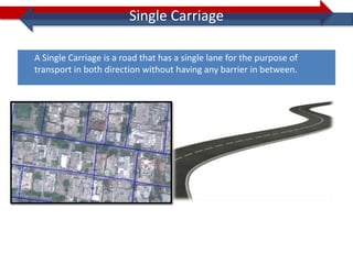
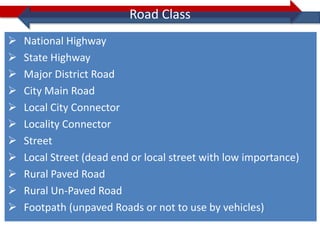
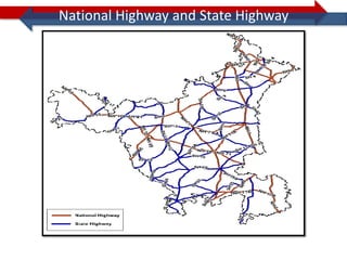
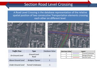
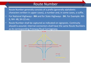
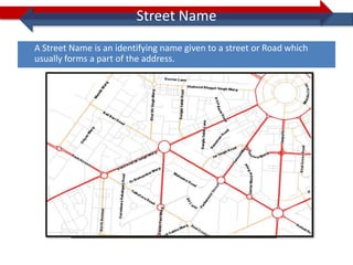
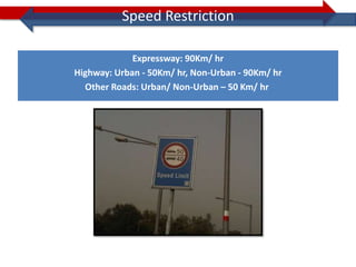
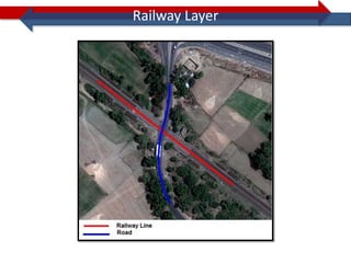
Accurate Navigation Maps


                  From:
Content Detail
City Coverage
• eNav Cities Coverage 658 Cities
• Cities with Dual Carriage317 Cities
India Coverage
• India Road Network 22,11,449 Km
• National Highway Roads69,825 Km
• State Highway Roads90192 Km
• Roads with Standard name32,120 Km
• Route Numbers on Roads154,715 Km
Railway coverage
• Rail Coverage Network 65,762 Km

 Data verified through extensive ground survey
 OEM to MapInfo StreetPro
 Large number of of POIs across 100 categories
Road Layer Fields
Road Types
Road Types

   Expressway
   Dual Carriage
   Single Carriage
   Roundabout
   Major Slip Road
   Parallel Road
   Service Road
   Parking (Entrance to/ Exit from a Car Park)
   Small Slip Road
   Special Traffic Figure
   Pedestrian Zone
Expressway
It is a road that has official recognition & which is crossing at a different
level and is connected to the rest of the road network by means of major
slip roads.
•For classifying as an expressway a road should be >= 2 km.
•For < 2km the road would be classified as Dual Carriage way.
Dual Carriage
    A Dual Carriage is the representation of a road, by means of
splitting two different Carriages due to physical barrier split in two
                         opposite direction.
Dual Carriage
Single Carriage

A Single Carriage is a road that has a single lane for the purpose of
transport in both direction without having any barrier in between.
Roundabout
Roundabout is a type of circular intersection, a junction in which road traffic flows
                    in one direction around a central island.
Roundabout

For classifying as a roundabout the diameter must be > 5m and <120m
Major Slip Road
A major Slip Road is a road that generally connects roads crossing at different levels.


                      Major Slip Road     Multi-level Crossing


                                                  Legend
Small Slip Road
A Small Slip Road is a road specially designed to ensure a connection between two roads.
This connection is used to leave one road and drive smoothly to the other road particularly
to avoid a crossing at the same level. A small slip road is > 7.5 m and < 120 m.


                         Small Slip Road
Service Road
A Service Road is a local road running parallel to a higher connectivity road.


                                                       Service
                                                       Road
Special Traffic Figure
Special Traffic Figure and Closed Structure of Roads
A Special Traffic Figure refers to a closed circular, elongated or rectangular formation
   of roads that is not recognized as a roundabout because:
• one or more roads run through the formation;
• of the direction of traffic flow


                  Special Traffic Figure   Grade Separated Crossing   Driving Direction
                                           Road Network Geometry      Inaccessible Road
Special Traffic Figure
• Delhi – India Gate roundabout
Road Class
Road Class
   National Highway
   State Highway
   Major District Road
   City Main Road
   Local City Connector
   Locality Connector
   Street
   Local Street (dead end or local street with low importance)
   Rural Paved Road
   Rural Un-Paved Road
   Footpath (unpaved Roads or not to use by vehicles)
National Highway and State Highway
Major District Roads
Major District Road: which are officially in use & recognized as major connection
between different neighbouring Major District Head Quarters within state or region
Other Road Classes
City Main Road: Roads that connect the Main Roads of a town or City.
Local City Connector: Provides the connection between two local cities.
Locality Connector: Provides connections between localities to other localities.
Street: Main road that provides the connection to all local or dead end roads of
a locality.
Dead end Street: All Street and dead end roads.
Traffic Flow
Traffic Flow
   Traffic Flow: is the database representation of the allowed direction of
                            traffic flow on a road.

                                    Traffic Flow                                 Value
                              Open in both directions                             0
        Traffic Flow in the same direction as that of arrow of digitization       1

       Traffic flow in the opposite direction as that of arrow of digitization    2

           Inaccessible (Closed in both directions for General Vehicles)          3


Arrow of Digitization: - Arrow of digitization is the direction in which the
geometry has been digitized.
Traffic Flow
1) Open in Both directions (Data Base Value=0):


2) Traffic Flow is along the arrow of digitization (Data Base Value=1):


3) Traffic flow in the opposite direction as that of arrow of digitization (Data
    Base Value=2)
Traffic Flow
4) Inaccessible(Data Base Value=3):
Section Road Level Crossing
     A Road Level Crossing is the database representation of the relative
    spatial position of two consecutive Transportation elements crossing
                         each other on different level.


   Traffic Flow            Type          Database Value
                       Ground Level
 On Ground Level                               0
                          Road
Above Ground Level    Bridges/ Flyover         1

Under Ground Level   Tunnel/ Underpass         -1
Section Route Number
Route Number
  Route Number generally consists of a prefix (generally alphabetic
  characters written in upper cases), a number and, in some cases, a suffix.
• For National Highways - NH and for State Highways - SH. For Example: NH-
  6, NH- 48, SH-22 etc.
• Route Number shall be captured as indicated on signposts. Continuity
  should is assured. Internal connectors shall have the same Route Numbers
  as its corresponding Freeway/Dual Carriageway.
Street Name
Street Name
A Street Name is an identifying name given to a street or Road which
usually forms a part of the address.
Street Name
• Standard Name (SN) - is the most common name of a real-world object.
• Alternate Name (AN) - is an alternative for the most common name for a
  real-world object.
Speed Restriction
Speed Restriction

             Expressway: 90Km/ hr
Highway: Urban - 50Km/ hr, Non-Urban - 90Km/ hr
  Other Roads: Urban/ Non-Urban – 50 Km/ hr
Other Layers
Railway Layer
Waterway Layer
Other Features
Other Features
Signpost - Branch Signs identify a specific distination at the end of the ramp and Towards Signs is specific
destination beyond the ramp end.


Ramp - Exit from the main road OR Entrance to the main road from the road of difference level.


Time Related Information (TRI) - Roads are open or Closed for a specific time period.


Blocked Passage - Road closed for all vehicle or a particular vehicle type.


Maximum Dimensions - Maximum Dimension is the largest acceptable limit on road that is generally below the
bridge or over the bridge etc. Like 2.5 m (for Height), 450 T (for Weight) etc.

Rest Areas - A rest area or service area is a public facility, located next to a large thoroughfare such as a
highway, expressway, or freeway at which drivers and passengers can rest, eat, or refuel without exiting on to
secondary roads.


Lane Information - Information on numbers and types of lanes present on any road.
Other Features

Maneuver - Maneuver gives the information about the next raod attached to the present road, Like
Restricted, Prohibited, Priority, Implicit etc.

Toll Way - A Toll way is road for which a fee is collected in order to use the road. These are typically
controlled access roads where the fee varies over distance travelled.

Parking - It’s a road element which is the part of parking lot.


Intersection - Intersection is the crossing between 2 or more than 2 roads on the same level.

Freeway Intersection - Intersection is the crossing between 2 or more than 2 roads on the different
level.

Traffic Lights - Traffic Lights gives the instruction for the traffic movement.

Parallel Road - A Parallel Road refers to a parallel road that gives access to one or more level crossing via
major slip roads

Pedestrian Path - A Pedestrian Zone refers to paths, passages, promenades; that are too narrow or
otherwise physically restricted for cars. Walkways can be named or unnamed, paved or unpaved.
Process Flow

   Area            MOD approval    Satellite Image
Demarcation         for Survey      Procurement


DGPS Survey /                      Field Survey/
    Image          Data Creation     Attribute
 Rectification                       Collection


    Data                           MOD Approval
                   Quality Check
 Integration                         of Data


  Delivery
Survey Method – DGPS
Survey Method – Camera Drive
Thank You!

Navigation maps

  • 1.
  • 2.
    Content Detail City Coverage •eNav Cities Coverage 658 Cities • Cities with Dual Carriage317 Cities India Coverage • India Road Network 22,11,449 Km • National Highway Roads69,825 Km • State Highway Roads90192 Km • Roads with Standard name32,120 Km • Route Numbers on Roads154,715 Km Railway coverage • Rail Coverage Network 65,762 Km  Data verified through extensive ground survey  OEM to MapInfo StreetPro  Large number of of POIs across 100 categories
  • 3.
  • 4.
  • 5.
    Road Types  Expressway  Dual Carriage  Single Carriage  Roundabout  Major Slip Road  Parallel Road  Service Road  Parking (Entrance to/ Exit from a Car Park)  Small Slip Road  Special Traffic Figure  Pedestrian Zone
  • 6.
    Expressway It is aroad that has official recognition & which is crossing at a different level and is connected to the rest of the road network by means of major slip roads. •For classifying as an expressway a road should be >= 2 km. •For < 2km the road would be classified as Dual Carriage way.
  • 7.
    Dual Carriage A Dual Carriage is the representation of a road, by means of splitting two different Carriages due to physical barrier split in two opposite direction.
  • 8.
  • 9.
    Single Carriage A SingleCarriage is a road that has a single lane for the purpose of transport in both direction without having any barrier in between.
  • 10.
    Roundabout Roundabout is atype of circular intersection, a junction in which road traffic flows in one direction around a central island.
  • 11.
    Roundabout For classifying asa roundabout the diameter must be > 5m and <120m
  • 12.
    Major Slip Road Amajor Slip Road is a road that generally connects roads crossing at different levels. Major Slip Road Multi-level Crossing Legend
  • 13.
    Small Slip Road ASmall Slip Road is a road specially designed to ensure a connection between two roads. This connection is used to leave one road and drive smoothly to the other road particularly to avoid a crossing at the same level. A small slip road is > 7.5 m and < 120 m. Small Slip Road
  • 14.
    Service Road A ServiceRoad is a local road running parallel to a higher connectivity road. Service Road
  • 15.
    Special Traffic Figure SpecialTraffic Figure and Closed Structure of Roads A Special Traffic Figure refers to a closed circular, elongated or rectangular formation of roads that is not recognized as a roundabout because: • one or more roads run through the formation; • of the direction of traffic flow Special Traffic Figure Grade Separated Crossing Driving Direction Road Network Geometry Inaccessible Road
  • 16.
    Special Traffic Figure •Delhi – India Gate roundabout
  • 17.
  • 18.
    Road Class  National Highway  State Highway  Major District Road  City Main Road  Local City Connector  Locality Connector  Street  Local Street (dead end or local street with low importance)  Rural Paved Road  Rural Un-Paved Road  Footpath (unpaved Roads or not to use by vehicles)
  • 19.
    National Highway andState Highway
  • 20.
    Major District Roads MajorDistrict Road: which are officially in use & recognized as major connection between different neighbouring Major District Head Quarters within state or region
  • 21.
    Other Road Classes CityMain Road: Roads that connect the Main Roads of a town or City. Local City Connector: Provides the connection between two local cities. Locality Connector: Provides connections between localities to other localities. Street: Main road that provides the connection to all local or dead end roads of a locality. Dead end Street: All Street and dead end roads.
  • 22.
  • 23.
    Traffic Flow Traffic Flow: is the database representation of the allowed direction of traffic flow on a road. Traffic Flow Value Open in both directions 0 Traffic Flow in the same direction as that of arrow of digitization 1 Traffic flow in the opposite direction as that of arrow of digitization 2 Inaccessible (Closed in both directions for General Vehicles) 3 Arrow of Digitization: - Arrow of digitization is the direction in which the geometry has been digitized.
  • 24.
    Traffic Flow 1) Openin Both directions (Data Base Value=0): 2) Traffic Flow is along the arrow of digitization (Data Base Value=1): 3) Traffic flow in the opposite direction as that of arrow of digitization (Data Base Value=2)
  • 25.
  • 26.
  • 27.
    Section Road LevelCrossing A Road Level Crossing is the database representation of the relative spatial position of two consecutive Transportation elements crossing each other on different level. Traffic Flow Type Database Value Ground Level On Ground Level 0 Road Above Ground Level Bridges/ Flyover 1 Under Ground Level Tunnel/ Underpass -1
  • 28.
  • 29.
    Route Number Route Number generally consists of a prefix (generally alphabetic characters written in upper cases), a number and, in some cases, a suffix. • For National Highways - NH and for State Highways - SH. For Example: NH- 6, NH- 48, SH-22 etc. • Route Number shall be captured as indicated on signposts. Continuity should is assured. Internal connectors shall have the same Route Numbers as its corresponding Freeway/Dual Carriageway.
  • 30.
  • 31.
    Street Name A StreetName is an identifying name given to a street or Road which usually forms a part of the address.
  • 32.
    Street Name • StandardName (SN) - is the most common name of a real-world object. • Alternate Name (AN) - is an alternative for the most common name for a real-world object.
  • 33.
  • 34.
    Speed Restriction Expressway: 90Km/ hr Highway: Urban - 50Km/ hr, Non-Urban - 90Km/ hr Other Roads: Urban/ Non-Urban – 50 Km/ hr
  • 35.
  • 36.
  • 37.
  • 38.
  • 39.
    Other Features Signpost -Branch Signs identify a specific distination at the end of the ramp and Towards Signs is specific destination beyond the ramp end. Ramp - Exit from the main road OR Entrance to the main road from the road of difference level. Time Related Information (TRI) - Roads are open or Closed for a specific time period. Blocked Passage - Road closed for all vehicle or a particular vehicle type. Maximum Dimensions - Maximum Dimension is the largest acceptable limit on road that is generally below the bridge or over the bridge etc. Like 2.5 m (for Height), 450 T (for Weight) etc. Rest Areas - A rest area or service area is a public facility, located next to a large thoroughfare such as a highway, expressway, or freeway at which drivers and passengers can rest, eat, or refuel without exiting on to secondary roads. Lane Information - Information on numbers and types of lanes present on any road.
  • 40.
    Other Features Maneuver -Maneuver gives the information about the next raod attached to the present road, Like Restricted, Prohibited, Priority, Implicit etc. Toll Way - A Toll way is road for which a fee is collected in order to use the road. These are typically controlled access roads where the fee varies over distance travelled. Parking - It’s a road element which is the part of parking lot. Intersection - Intersection is the crossing between 2 or more than 2 roads on the same level. Freeway Intersection - Intersection is the crossing between 2 or more than 2 roads on the different level. Traffic Lights - Traffic Lights gives the instruction for the traffic movement. Parallel Road - A Parallel Road refers to a parallel road that gives access to one or more level crossing via major slip roads Pedestrian Path - A Pedestrian Zone refers to paths, passages, promenades; that are too narrow or otherwise physically restricted for cars. Walkways can be named or unnamed, paved or unpaved.
  • 41.
    Process Flow Area MOD approval Satellite Image Demarcation for Survey Procurement DGPS Survey / Field Survey/ Image Data Creation Attribute Rectification Collection Data MOD Approval Quality Check Integration of Data Delivery
  • 42.
  • 43.
    Survey Method –Camera Drive
  • 44.