1) Advances in satellite sensor calibration technology have enabled more accurate monitoring of global climate trends from space.
2) Prior satellite sensors had limitations like spectral resolution and radiometric accuracy that made establishing long-term climate records difficult.
3) New satellite instruments under development can provide continuous high-resolution spectral coverage, onboard calibration, and reduced measurement uncertainties, enabling undisputed climate monitoring from space.
PERSISTENT SCATTERER SAR INTERFEROMETRY APPLICATION.pptxgrssieee
This document discusses the application of persistent scatterer interferometry (PSI) to study landslides in the Berkeley Hills. PSI uses phase information from SAR images taken at different times to measure surface deformation with millimeter accuracy. It was applied using Envisat, ERS, Radarsat, and TerraSAR-X data. Thousands of persistent scatterers were identified, allowing measurement of surface motion along the Hayward Fault and within landslides. Future work will continue monitoring with additional SAR data to better resolve three-dimensional landslide motions.
This document discusses various techniques for monitoring landslides, including remote sensing, photogrammetry, ground-based surveying, GPS, and geotechnical methods. Remote sensing techniques discussed include synthetic aperture radar (SAR), interferometric SAR (InSAR), and RADAR systems which use radio waves to detect ground movement. Photogrammetry allows interpretation of aerial photos to identify landslides. Ground surveying employs techniques like triangulation and leveling. GPS provides location and velocity data through satellite signals. Geotechnical sensors monitor deformation underground through extensometers, inclinometers, piezometers, and other instruments.
This document discusses using k-means clustering to detect minerals from remote sensing images. It begins with an abstract describing using k-means clustering on hyperspectral images to segment and extract features to detect minerals like giacomo. It then provides background on remote sensing, k-means clustering algorithms, and describes the giacomo mineral deposit in Peru that contains silicon dioxide and titanium dioxide. It concludes with discussing using sobel edge detection as part of the mineral detection process from remote sensing images.
This document compares aerial photography and satellite remote sensing. [1] Aerial photography uses cameras mounted on aircraft to capture overlapping photos at fixed altitudes, while satellites capture continuous image strips from orbit. [2] Aerial photography provides higher resolution images but is limited by weather and environment, while satellites can image any location but provide lower resolution. [3] Both techniques image the electromagnetic spectrum, but satellites can capture non-visible data like infrared and radar not restricted by time of day.
Propagation Effects for Radar&Comm SystemsJim Jenkins
This three-day course examines the atmospheric effects that influence the propagation characteristics of radar and communication signals at microwave and millimeter frequencies for both earth and earth-satellite scenarios. These include propagation in standard, ducting, and subrefractive atmospheres, attenuation due to the gaseous atmosphere, precipitation, and ionospheric effects. Propagation estimation techniques are given such as the Tropospheric Electromagnetic Parabolic Equation Routine (TEMPER) and Radio Physical Optics (RPO). Formulations for calculating attenuation due to the gaseous atmosphere and precipitation for terrestrial and earth-satellite scenarios employing International Telecommunication Union (ITU) models are reviewed. Case studies are presented from experimental line-of-sight, over-the-horizon, and earth-satellite communication systems. Example problems, calculation methods, and formulations are presented throughout the course for purpose of providing practical estimation tools.
Iirs lecure notes for Remote sensing –An Overview of Decision MakerTushar Dholakia
The document provides an overview of remote sensing including:
1) Defining remote sensing as acquiring information about Earth's surface without physical contact using sensors to detect reflected or emitted energy.
2) Describing the basic components and processes of remote sensing including emission, transmission, interaction with the surface, and sensor data acquisition.
3) Detailing the interaction of electromagnetic radiation with Earth's surfaces and the information that can be derived from changes in magnitude, direction, wavelength and other properties.
4) Explaining the different types of remote sensing platforms, sensors, resolutions and wavelengths used in remote sensing from visible light to microwaves.
5) Providing an overview of Indian remote sensing satellites
The document discusses the use of Synthetic Aperture Radar (SAR) and InSAR techniques for monitoring solid earth geophysics hazards. SAR uses microwaves to generate high-resolution images of the Earth's surface independently of solar illumination. InSAR uses multiple SAR images to measure surface changes down to the centimeter scale, such as caused by earthquakes or subsidence. It discusses various InSAR techniques including DifSAR, Persistent Scatterer InSAR, and Corner Reflector InSAR and their applications in oil and gas, mining, infrastructure and hazard monitoring. The document also lists several commercial and open-source InSAR processing software packages.
JPSS will continue critical environmental monitoring from polar orbiting satellites by maintaining observations from sensors like CrIS, ATMS, VIIRS, OMPS, and CERES. The NPP satellite will fly the first set of these instruments in order to ensure continuity of data until JPSS-1 is launched. JPSS will provide global observations for weather forecasting and climate monitoring through environmental data records from multiple instruments measuring atmospheric, oceanic, and land surface variables. Continuity of long term data sets is essential for detecting climate change and improving weather prediction.
PROGRESSES OF DEVELOPMENT OF CFOSAT SCATTEROMETERgrssieee
The document describes the progress of the development of CFOSAT SCAT, a Ku-band scatterometer onboard the Chinese-French Oceanography Satellite (CFOSAT). CFOSAT will measure global ocean surface winds and waves to improve weather forecasting, ocean dynamics modeling, climate research, and understanding of surface processes. The SCAT instrument is a rotating fan-beam radar scatterometer that will retrieve wind vectors using measurements of backscatter at incidence angles from 26 to 46 degrees. It has a wide swath of over 1000km and specifications are designed to achieve high-precision wind measurements globally. System details including parameters and the operation mode are provided.
The document discusses image distortion effects in subsurface synthetic aperture radar (SAR) imaging of deserts and proposes an iterative corrective approach. It summarizes that subsurface SAR can map subsurface topography under sand but images are distorted due to geometric distortion and defocusing. It then proposes using dual-frequency SAR, with VHF penetrating sand and Ka imaging the surface, along with an iterative algorithm using the surface data to correct the VHF image and retrieve accurate subsurface heights. Simulation results showed the approach improved height resolution and coherence by 20-40% compared to conventional SAR.
Propagation Effects and Their Impact on Satellite-Earth Links: Introduction,
Quantifying attenuation and depolarization,
Propagation effects that are not associated with hydrometeors, Prediction of rain attenuation,
Prediction of XPD,
Propagation impairments countermeasures.
This document describes the development of an airborne lidar instrument called A-LISTS to demonstrate technologies for a proposed spaceborne lidar mission called LIST. LIST aims to map global topography at 5m resolution to study Earth's surface and changes over time. A-LISTS will test a multi-beam laser transmitter, high sensitivity detectors, and data processing to achieve LIST measurement capabilities from an aircraft. Its first flight in September 2011 will collect lidar data over various terrain to evaluate performance. Key challenges for LIST that A-LISTS helps address include detecting ground returns through vegetation canopies and developing efficient, lightweight instruments.
This presentation consist of remote sensing, types of remote sensing and also about the radiometers systems. I have also discussed about the types of radiometers system and how it work. I have also discussed about the principle on which it works. Also I have discussed about the applications .
Intrusion Detection In Open Field Using Geophone (Presentation)Nuthan Prasad
- The document presents a method for intrusion detection in open fields using geophones to detect seismic waves generated by intruders.
- A sensor node is developed that uses a geophone, amplifier, band-pass filter, envelope detector, and microcontroller to analyze seismic signals and detect intrusions based on the kurtosis of the signals.
- If an intrusion is detected, the sensor node wirelessly notifies an unmanned vehicle (UGV) which uses GPS to navigate to the location and take appropriate action. The overall system aims to provide security over large open areas that traditional camera-based methods cannot adequately cover.
This study investigated the use of aerial photographs collected from an unmanned aerial vehicle (UAV) to map and monitor mangrove communities in Port Hedland, Western Australia at a high spatial resolution. The UAV collected imagery of mangrove sites with a pixel size of 2cm, allowing classification of mangroves down to the individual plant level. Analysis of the imagery found that the two dominant mangrove species, Avicennia marina and Rhizophora stylosa, made up 88% of the living canopy cover across the two study sites. The high resolution imagery from the UAV provides an effective method for detailed and frequent monitoring of mangrove community composition and health.
Application of Ground Penetrating Radar in Subsurface mapping Dr. Rajesh P Barnwal
The document summarizes a study that used ground penetrating radar (GPR) to map subsurface sand layers at a beach in Nagoor, India impacted by the 2004 Indian Ocean tsunami. GPR profiles along a 60m transect and trench revealed dipping sediment layers deposited by coastal waves. Multiple sand and heavy mineral layers were identified below 1m depth, indicating the tsunami eroded the surface and deposited new layers. Granulometric data from sediment cores correlated well with GPR readings, demonstrating GPR's effectiveness in mapping tsunami-impacted subsurface geology.
This document outlines validation plans for the Ozone Mapping and Profiler Suite (OMPS) instrument on the NPOESS Preparatory Project satellite. It discusses:
1) The calibration and validation team members and their roles in characterizing instrument performance through comparisons with other satellite and ground-based instruments from launch through long-term monitoring.
2) The schedule of major validation tasks from pre-launch testing through intensive in-orbit validation in the first two years and transition to long-term monitoring.
3) Examples of early tests and comparisons that will be done with internal instrument measurements, early solar views, and single days of Earth view data to evaluate performance.
The document discusses ground penetrating radar (GPR), which uses radar pulses to image the subsurface. It explains that GPR can detect objects, material changes, and voids underground. The document then covers GPR principles, data acquisition, analysis, and applications in civil engineering projects like assessing bridge decks, detecting subsidence, and locating cultural artifacts. Examples of current GPR research, equipment, and software are also presented.
This presentation cover description of microwave remote sensing, Active and Passive Microwave remote sensing, RADAR, Slant range distortion like Foreshortening and Layover, Sar image and some Recent works in where microwave remote sensing has used to detect natural calamities
The document discusses improvements to satellite imaging technology, focusing on the new Advanced Baseline Imager (ABI) onboard GOES-R satellites. ABI will provide higher resolution images, new spectral channels, and improved temporal resolution compared to current GOES imagers. Specifically:
1) ABI will capture visible, infrared, and near-infrared channels at finer resolutions of 0.5-2km compared to 1-4km for current imagers.
2) It adds new spectral channels that improve monitoring of vegetation, fires, snow/ice, and hurricane intensities.
3) ABI allows for more frequent full Earth scans every 15 minutes compared to every 26 minutes currently, improving weather monitoring capabilities.
Summary of current radiometric calibration coefficients for Landsat MSS, TM, ETM+,
and EO-1 ALI sensors
Gyanesh Chander a,⁎, Brian L. Markham b, Dennis L. Helder c
a SGT, Inc. 1 contractor to the U.S. Geological Survey (USGS) Earth Resources Observation and Science (EROS) Center, Sioux Falls, SD 57198-0001, USA
b National Aeronautics and Space Administration (NASA) Goddard Space Flight Center (GSFC), Greenbelt, MD 20771, USA
c South Dakota State University (SDSU), Brookings, SD 57007, USA
Cavities detection with ground penetrating radar in limestone dominated rock ...Firman Syaifuddin
As one of geophysical method ground penetrating radar uses electromagnetic wave propagation to detecting the anomaly object, the strong relationship between the physical properties of geological material and their electromagnetic properties enable to identification of physical structures in the sub surface. Cavities in limestone dominated rock formation sometimes made problem when construction build above in this area, as prevention to the damage affected by cavities, before construction starting to build we have to identified the possible cave location to preparing special treatment to minimize the risk. Present of cavities give electromagnetic anomaly event and the reflection signal representing changing of electrical properties when we use ground penetrating radar. We applied attributes extraction adopted from seismic method to extracting information about cavities. We use sweetness attribute extraction to identified present of cavities in limestone dominated rock formation
Sensor Network for Landslide Monitoring With Laser Ranging System Avoiding Ra...Waqas Tariq
Sensor network for landslide monitoring with laser ranging system is developed together with landslide disaster relief with remote sensing satellite imagery data. Time diversity is utilized for rainfall influence avoidance in the distance measurements between laser ranging equipment and targets. Also automatic tie point extraction method is proposed. Experimental results show that (1) the proposed time diversity of the laser ranging measurement does work for avoidance from rainfall influence; (2) the proposed automatic control point extraction method does work for tie point matching together with change detection for landslide disaster relief.
Hyperspectral remote sensing uses narrow, contiguous bands across the electromagnetic spectrum to characterize vegetation. It is useful for studying species composition, crop/vegetation type, biophysical properties like leaf area index and biomass, biochemical properties like chlorophyll and moisture, and stress factors. Hyperspectral data comes from airborne, ground, and spaceborne sensors, with spaceborne providing global continuous coverage but at lower spatial resolution than airborne sensors. Hyperspectral data cubes contain hundreds of bands providing detailed spectral signatures to distinguish vegetation.
This document discusses ground penetrating radar (GPR), including its principles, applications in civil engineering, equipment, and data acquisition process. GPR works by sending electromagnetic pulses into material and detecting reflected signals to map subsurface structures. It can locate utilities, cavities, and determine pavement/bridge deck thickness. Lower frequencies provide deeper penetration but lower resolution. GPR systems use different antenna frequencies ranging from 25-1500 MHz. The document explains how dielectric constants affect electromagnetic wave velocities and provides an example calculation for object depth detection. It also outlines the key components of GPR equipment and surveys.
This document summarizes the applications of ground penetrating radar (GPR) and provides an overview of GPR techniques. GPR can be used for environmental and archaeological surveys to map contaminant plumes, locate buried structures, and delineate boundaries. It can also be applied to oil and gas surveys, and civil engineering projects to locate utilities and rebar in concrete. The advantages of GPR include its non-intrusive nature and ability to image below ground surfaces. However, it also has limitations such as expense, limited penetration depth, and need for trained operators and sophisticated software for data processing and interpretation.
The Premier Seat Program allows members access to preferred seating areas at the Marcus Amphitheater during Summerfest concerts. There are two club levels to choose from, the Platinum Club and Gold Club, which provide the same seats for every show. Members also receive benefits like access to private hospitality areas with food and drinks, preferred parking, and some tax deductibility for the Platinum Club fee. The lineup for Summerfest 2010 is announced, featuring performers like Tim McGraw and Carrie Underwood.
La Unión Europea ha acordado un paquete de sanciones contra Rusia por su invasión de Ucrania. Las sanciones incluyen restricciones a las importaciones de productos rusos de alta tecnología y a las exportaciones de bienes de lujo a Rusia. Además, se congelarán los activos de varios oligarcas rusos y se prohibirá el acceso de los bancos rusos a los mercados financieros de la UE.
El SANTUARIO ANTE EL MARKETING DEL DESTINO RELIGIOSO Syddney Potoy
El documento describe el santuario como un lugar sagrado de peregrinación y encuentro con lo divino, que atrae a multitudes movidas por la fe. Sin embargo, alrededor de los santuarios también surgen actividades comerciales y de marketing. El documento explora cómo los santuarios pueden dialogar con estas dinámicas de manera que no manipulen lo sagrado, proponiendo líneas de distinción, apoyo mutuo y trabajo en común entre lo religioso y lo comercial.
Tom Carvel started selling ice cream from the back of a truck in 1934 after borrowing $15 from his wife. He went on to create one of the first soft serve ice cream machines and pioneered the franchising model by educating franchise owners and charging royalties. By the 1950s he had 25 stores and became famous for starring in unconventional marketing commercials. Carvel later established a charitable foundation and by 1984 his company had over 865 franchises and $300 million in annual sales.
This document discusses remote sensing. It defines remote sensing as acquiring information about objects without direct contact, using electromagnetic radiation. It describes how remote sensing uses platforms like aircraft and satellites to collect passive and active sensor data. It provides examples of different sensor types, including photography, infrared, LIDAR, and multispectral scanning. It also discusses important remote sensing concepts like spatial, spectral, radiometric, and temporal resolution. Finally, it highlights how the SLOSH model uses remote sensing data to accurately predict hurricane storm surges and inundation areas.
Vicarious radiometric calibration refers to techniques used to calibrate remote sensing data without relying on onboard calibrators. Field spectroradiometers can be used to collect ground reflectance spectra and atmospheric parameters needed for vicarious calibration. Accurate vicarious calibration allows correction of instrument drift over time and comparison of datasets from different sensors, enabling monitoring of climate variables. Portable spectroradiometers like ASD's FieldSpec models are well-suited for rapid collection of calibration target and atmospheric data in the field.
Design and First Results of an UAV-Borne L-Band Radiometer for Multiple Monit...Angelo State University
This document describes the design and initial results of an L-band radiometer mounted on an unmanned aerial vehicle (UAV) for soil moisture monitoring. The radiometer measures antenna temperature with 1.27K resolution. Software processes the raw data, applying calibration and georeferencing to produce soil moisture maps. Initial field tests show the system can distinguish between soil, water and sun glint reflections. The UAV system provides flexibility and high resolution for applications like precision agriculture compared to spaceborne radiometers.
This document discusses seismic reflection methods and their application to shallow subsurface exploration problems. It provides an overview of seismic reflection fundamentals, including how reflections are generated at acoustic impedance contrasts and how common depth point (CDP) processing works to enhance reflection signals. The document also discusses data acquisition parameters and challenges of shallow seismic reflection, and gives examples of applications such as mapping geologic layers, faults, and cavities.
WE4.L10.5: ADVANCES IN NIGHTTIME SATELLITE REMOTE SENSING CAPABILITIES VIA TH...grssieee
The document discusses new capabilities for nighttime satellite remote sensing that will be enabled by the Visible Infrared Imaging Radiometer Suite (VIIRS) Day/Night Band (DNB) sensor on the Joint Polar Satellite System. The DNB will allow detection of low levels of visible light, enabling observations of clouds, aerosols, snow cover and other environmental parameters at night. It provides examples of potential multi-spectral applications using the DNB, including lunar reflection methods, detection of clouds, fires, dust, and city lights. The high resolution nighttime data from DNB presents opportunities to augment existing environmental data records.
The Man Made Effects on Space Weather Tiger Team was established to study potential impacts of human activities on space weather and ensure the space weather architecture study addressed these impacts. The team identified differences between natural and man-made space weather effects, such as the size and duration of electromagnetic and particle radiation. They found that space weather sensors may not adequately detect nuclear events and recommended integrating nuclear detection and space weather data, establishing an agency responsible for characterizing nuclear events, and expanding satellite coverage to reliably monitor radiation belt evolution.
The Quake-Catcher Network Rapid Aftershock Mobilization!Ali Osman Öncel
This document summarizes the Quake-catcher Network's (QCN) rapid deployment of low-cost accelerometers in Chile following the 2010 M8.8 Maule earthquake. The QCN recorded over 120 seconds of strong shaking from the mainshock with its single sensor in Chile at the time. After the mainshock, the QCN Rapid Aftershock Mobilization Program deployed 100 additional low-cost accelerometers across Chile over the next few weeks, significantly increasing the network's density for recording aftershocks. The new sensors provided high-resolution data on ground shaking across the region.
This document summarizes advances in radar remote sensing techniques for observing the Earth's atmosphere. It describes the structure of the atmosphere and the basic principles of radar. It highlights how radar has been used to study different layers of the atmosphere over time, from precipitation measurement in the lower atmosphere to ionospheric and middle atmosphere studies. Key radar facilities are discussed like the MU radar in Japan, which uses active phased array techniques to profile winds with high resolution. Applications of radar like gravity wave and turbulence measurements are summarized. The document conveys that atmospheric radars have become powerful tools for revealing atmospheric processes and will continue contributing to climate studies in the future.
The document discusses advances in radar remote sensing techniques for observing Earth's atmosphere. It describes the structure of the atmosphere and the basic principles of radar techniques. Recent radar systems like the MU radar in Japan can measure atmospheric parameters like wind velocity with high temporal and altitude resolution. Radars have been used to study dynamics in the upper, middle, and lower atmosphere. Atmospheric gravity waves observed by radar modulate wind profiles and transport momentum, affecting atmospheric structure. Range imaging techniques allow reconstruction of time series and Doppler spectra at any height within the radar observation volume.
This document proposes a technology using magneto-optic thin film sensors to study magnetic fields in deep space through wide-area arrays deployed by spacecraft. Each sensor would measure local magnetic fields and disturbances, with data communicated to reconstruct magnetic activity over large regions. The arrays could also control large space systems through parallel computing principles. The sensors use bismuth-substituted iron-garnet films that respond to magnetic fields through the magneto-optic Faraday effect, providing high sensitivity and domain wall velocity. Deployed arrays would allow unprecedented magnetic mapping beyond spacecraft's direct reach.
Radio beacon for ionspheric tomography RaBITKarlos Svoboda
This document presents preliminary results from the Radio Beacon for Ionospheric Tomography (RaBIT) payload onboard the YOUTHSAT satellite. RaBIT transmits signals at 150 and 400 MHz that are received by ground stations in India to generate tomographic images of the ionosphere. The first tomograms obtained using RaBIT data during the beginning of solar cycle 24 are shown, demonstrating its ability to investigate large-scale ionospheric structures over the Indian region like the equatorial ionization anomaly. RaBIT improves upon previous experiments by providing improved temporal coverage of the ionosphere from its orbit onboard YOUTHSAT.
ASES WREF 2012 Solar Monitoring, Forecasting and Variability Assessment at SMUDpramodkrishnani
The paper summarizes the deployment of a 71 station solar monitoring network in Sacramento, California, and its use in validating variability relationships as well as satellite based irradiance datasets. The data cleanup methods are described for eliminating shading artifacts in the ground-based solar monitoring data. The cleaned data is then evaluated to confirm theoretical relationships of spatial correlation between PV plants developed by Hoff and Perez. The relationships are confirmed for 1 minute, 5 minute, and 10 minute timeframes. Additionally, the ground-based datasets are compared to satellite datasets for determining error. Possible sources of error are discussed, and results show that for a half hour timeframe, error or difference in GHI is between 6 and 11%. For DNI, errors range from 17 – 22%. A portion of the errors can be attributed to bias, with GHI bias ranging from between -1 and -7% indicating satellite estimated slightly greater GHI resource and DNI bias ranging from between -1 and 11%, indicating generally that the ground-based RSR’s measured slightly greater values than the satellite datasets.
This study measured environmental radioactivity in Palestine using in situ gamma-ray spectroscopy. Measurements were taken at 18 locations across the West Bank. The detected radionuclides were naturally occurring gamma emitters from 238U, 232Th and 40K decay chains, with 137Cs also identified at a few locations. Activity concentrations ranged from 8-203 Bq/kg for 40K, 6-32 Bq/kg for 238U and 5-30 Bq/kg for 232Th. The total outdoor gamma dose rate was calculated to be 6-30 nGy/h, with an average of 18 ± 7 nGy/h or about 30% of the world average. The results provide a baseline for environmental
This document summarizes and compares different spectrum sensing methods for cognitive radio networks. It discusses periodogram and multitaper methods (MTM) for power spectrum estimation. MTM addresses problems with periodogram like bias and variance. Receiver operating characteristic (ROC) curves are used to compare detection performance of different methods. MTM performance depends on number of tapers and time-bandwidth product. The paper evaluates MTM in terms of these and other parameters. It also provides background on cognitive radio, IEEE 802.22 networks, and the cognitive cycle of spectrum sensing, analysis and decision making. Experimental results comparing periodogram and MTM methods are presented.
Radar fundamentals introduces key concepts of radar remote sensing. Radar transmits and receives microwave signals to image the Earth's surface. There are two main types of radar systems - Real Aperture Radar (RAR) and Synthetic Aperture Radar (SAR). SAR uses antenna movement to synthesize a larger antenna and achieve higher resolution. Radar backscatter is influenced by system parameters like wavelength, polarization, and incident angle as well as target characteristics such as surface roughness and electrical properties. SAR images provide unique views of the Earth's surface and are important tools for environmental and military applications.
This document discusses using GIS software to identify the shortest and most economical route for a national highway alignment between Palani and Erode in Tamil Nadu, India. It considers factors like land use, geology, land value, and soil type by assigning weights and ranks to each theme. The themes are then overlaid in GIS to identify the most suitable highway alignment area. Conventional manual methods for route selection were difficult, time-consuming, and expensive compared to the proposed GIS-based approach.
This course examines atmospheric propagation effects on radar and communication signals, covering topics like standard and anomalous propagation conditions, ducting phenomena, atmospheric measurements, propagation modeling techniques, and the impact of propagation on system performance. Case studies are presented from experimental line-of-sight, over-the-horizon, and earth-satellite systems. The instructor has extensive experience modeling electromagnetic propagation in the troposphere and predicting environmental impacts on radar and communications.
IRJET- Soil Water Forecasting System using Deep Neural Network Regression ModelIRJET Journal
This document discusses using a deep neural network regression model to forecast soil water content. It first describes collecting soil echo data using ultra-wideband radar, which does not require pre-building a feature database. It then transforms the echo data into time-frequency distribution patterns using Wigner-Ville and Choi-Williams distributions as inputs for convolutional neural network models. Four systems using different time-frequency transforms and neural networks are constructed and tested on soil echoes with varying water contents and signal-to-noise ratios, with the Wigner-Ville distribution and AlexNet network achieving the best recognition performance. Existing methods like convolutional neural networks, artificial neural networks, and deep neural networks for soil moisture estimation are also summarized.
Ground Penetrating Radar (GPR) has the ability to map subsurface geological structures and detect variations in moisture that could help understand geothermal exploration. However, GPR is limited to shallow depths of less than 50 meters, where most geothermal reservoirs are located. This study uses GPR data from Beijing to create digital models of the subsurface and identify potential geothermal indicators like quartz sinters. The results demonstrate GPR's capability to detect geochemical markers associated with geothermal activity and map prospective geothermal reservoir locations. While GPR has limitations for deep exploration, it shows potential as a new efficient tool for initial geothermal prospecting.
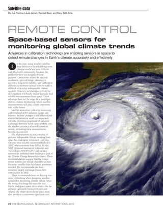
1. Satellite data
By Joe Predina, Laura Jairam, Randall Bass, and Mary Beth Crile
REMOTE CONTROL
Space-based sensors for
monitoring global climate trends
Advances in calibration technology are enabling sensors in space to
detect minute changes in Earth’s climate accurately and effectively
n the past, using weather satellite
I data archives to establish long-term
climate trends has been difficult
and filled with controversy, because the
platforms were not designed for the
purpose. Limitations related to spectral
resolution, spectral range, radiometric
accuracy, long-term stability, and calibration
differences between various sensors made it
difficult to develop indisputable climate
records. However, technology currently in
development will finally enable accurate and
reliable measurements from space. These
advances have set the stage for a paradigm
shift in climate monitoring, where satellite
measurements will play a more important
role in the future.
Satellite sensors are critical in measuring
and trending Earth’s radiation budget and
balance. Because changes in the reflected and
emitted radiation are small in comparison
with the enormous magnitude of radiation
exchanged between Earth, space and the sun,
the absolute accuracy achieved by remote
sensors in making these measurements
becomes paramount.
The measurement accuracy needed to
perform indisputable climate trending from
space has undergone refinement over time,
with the most notable consensus reached in
2002, when scientists from NASA, NOAA,
NIST (National Institute of Standards and
Technology), NPOESS-IPO, and various
universities published their findings as part of
the Climate Change Research Initiative. These
recommendations suggest that the remote
sensor stability per decade should be at least
five times smaller than the climate parameter
trended. The recommendations have
remained largely unchanged since their
introduction in 2002.
These recommendations are forcing new
ways of thinking when designing satellite
sensors for measuring climate trends. Since
the energy exchange between the sun,
Earth, and space spans ultraviolet to the far
infrared (generally between 0.2µm and
50µm), the observations from space must
also produce a continuous spectrum over
2 6 • ME TEOROLOGICAL TECHNOLOGY INTERNATIONAL 2010
2. Satellite data
“Technology has evolved to the point
where prior limitations associated with
satellite observations can be eliminated”
ITT has supplied multispectral imagers and
sounders to weather forecasting services for more
than 50 years. Hurricane Floyd, 1999 (Photo
courtesy NASA Goddard Space Flight Center)
the same range to validate scientific models.
The spectral resolution achieved must be
fine enough to enable development of better
spectroscopic atmospheric models and to
improve the knowledge of Earth surface
properties. New hardware architectures,
calibration methods, and associated ground
processing are required to support the
accurate parameter measurements.
For example, radiance observations in
the visible spectrum must be calibrated
about 10 times more accurately than current
methods. Brightness temperature
uncertainty for radiometers must approach
current NIST characterization limits of 0.01-
0.03K in the infrared bands and maintain
this level of calibration for at least 10 years
while on orbit. Spectral calibration and high
spectral resolution of radiance observations
are essential for identifying changes in the
concentration of trace gas species such as
greenhouse gases. Finally, trending of Earth
cloud fraction, aerosol content, and surface
vegetation characteristics will be vitally
important to future climate models.
Limitations of early space sensors
Weather satellite sensors designed in the
past primarily exploited information-rich
segments of Earth’s spectrum for the
purpose of short-term weather forecasting or
real-time nowcasting. The number of
spectral channels spanning the infrared,
visible or microwave bands was typically
very small for any particular remote sensor.
The typical channel bandwidth of filter
radiometers was broad in comparison with
today’s standards and incapable of resolving
fine spectral features of the atmosphere. In
addition, the detailed spectral response
shape of these radiometers was primarily
governed by one or more optical band pass
filters that were characterized in detail for
each instrument prior to launch.
ME TEOROLOGICAL TECHNOLOGY INTERNATIONAL 2010 • 2 7
3. Satellite data
Typical radiation balance between Earth, sun and
space averaged over 24 hours (Reprinted with
permission of Trenberth)
Satellites bring NIST on board
Breakthrough technologies under
development at ITT are changing how
space-based remote sensing will be
performed for climate trending. It essentially
brings NIST capabilities on board the
spacecraft. Some of these include greater
than 0.999 emissive broadband infrared
blackbody reference targets that provide
international standard traceability to within
0.015K over the life of the reference target.
Other NIST capabilities include
To date, space-based remote sensors have Days, and Seasons (ASCENDS), are hyperspectral radiometer hardware
been spectrally and radiometrically calibrated overcoming this problem. Technology has employing FTS and associated software
on the ground. Once on orbit, the calibration evolved to the point where prior limitations calibration techniques, as well as linearity
tended to slowly degrade over time due to associated with satellite observations can be characterization and compensation methods
normal aging and drift processes associated eliminated. The new class of instruments unique to FTS that can achieve 50ppm or
with the hardware. Additionally, despite under development is capable of providing better radiometric linearity while on orbit
detailed ground calibration and an order of magnitude reduction in over the full brightness temperature
characterization, the spectral response of one measurement uncertainties, better stability measurement range of a radiometer.
instrument was usually slightly different from over time, fi ner spectral resolution, and Other capabilities involve visible
other instruments in its series. more precise knowledge of the spectral calibration techniques to achieve
Radiometric calibration and the brightness response function. measurement accuracies approaching 0.2%
temperature measurement uncertainty
associated with these instruments depended “Space-based monitoring enables
on the quality of blackbody reference targets
carried on board the satellite or, in the case of uniform, global measurements to be
visible sensors, by the quality of an onboard
diffuser that used solar radiation as a
taken with fixed temporal periodicity,
reference. Both these methods were subject to regardless of ground access”
degradation over time, since the reference
target properties were determined on the Rather than sampling portions of the compared with the 2-3% currently accepted
ground. This calibration could not be renewed spectrum, these new sensors provide as standard; new detector technologies that
routinely after launch except by inference continuous spectral coverage at high push into the far infrared (15-50µm),
from many earth observations or comparison resolution. The calibrated output of making possible space-based measurements
with simultaneous balloon observations hyperspectral infrared sensors such as CrIS of earth emissions in this important
known as radiosondes. Neither of these and CLARREO will not differ from one wavelength range; and visible and ultraviolet
methods can achieve the necessary calibration instrument to the next in its series. It will hyperspectral methods using diffraction
accuracy/stability to produce undisputed no longer be necessary to adapt science grating or FTS technology.
climate records from space. analysis to the unique signature of a space- Active lidar sensors such as ASCENDS,
based remote sensor. Instead, radiance which use space-based lasers to probe the
High-resolution coverage measurements will be consistently mapped atmosphere for greenhouse gas signatures to
Future satellite architectures and to an identical user spectral grid that is accurately determine total column
technologies under development at ITT invariant from one sensor to the next and concentration, are a final technology.
Space Systems Division, such as the has identical spectral response shapes for all
Advanced Baseline Imager (ABI), the Cross- channelizations across a band. Digital Remote sensing from space, air, and
track Infrared Sounder (CrIS), Climate syntheses of spectral response functions the ground
Absolute Radiance and Refractivity inherent in Fourier transform spectrometers There are benefits and drawbacks in choosing
Observatory (CLARREO), and Active (FTS) are replacing inconsistent and a space-based approach to climate monitoring.
Sensing of CO2 Emissions over Nights, inaccurate analog optical filter techniques. One downside, perhaps the most significant,
2 8 • ME TEOROLOGICAL TECHNOLOGY INTERNATIONAL 2010
4. Satellite data
is the high cost of building and launching a
satellite system. A large amount of highly
skilled labor, specialized equipment, and
facilities are required. Furthermore, the risk
of mission failure can be precariously binary: Left: Prototype model of Advanced Baseline
even a small problem in implementation can Imager. Right: Image depicting ocean and
cause a launch anomaly or operational glitch atmospheric data generated by IDL, ITT’s
that drastically shortens sensor lifetime, such computing environment for data visualization
as the recent loss of the Orbiting Carbon and analysis
Observatory Satellite.
As outlined previously, calibration is Sensor integration sounders that helped to form the basis of
another key challenge in carrying out climate Sensors on airborne platforms can make today’s weather forecasts worldwide.
monitoring from space. Achieving the measurements to help fill the gaps between During 2009, ITT completed the
necessary precision and accuracy to detect ground sensors, and can measure localized prototype for the most advanced space
minute, slowly changing climate trends emission sources of greenhouse gases and weather instrument ever built to measure
requires onboard calibration systems that aerosols that may be missed by ground and track severe storms. The Advanced
exact additional engineering costs. Further sensors because of windspeed or altitude. Baseline Imager will monitor and measure
costs stem from the complex data acquisition Limitations of airborne sensors include the three times the number of atmospheric
systems required to collect and organize the inability to provide persistent surveillance conditions, provide data in seconds rather
pertinent auxiliary information for climate and the difficulty of synoptic or global than minutes or hours, and enable
analysis, with ground receiver stations that coverage, not to mention sensitive forecasters to zoom in on specific storms
may need to be coordinated across instruments being at the mercy of weather while monitoring the rest of the hemisphere.
international borders. Finally, for space conditions and aircraft vibration occurring An important advancement in
monitoring to be effective in the long term, a at the time of flight. atmospheric sounding capability will be
well-managed archival database is needed to Space-based monitoring enables uniform, available soon when the CrIS instrument
store records and disburse data to users in a global measurements to be taken with a joins the National Polar-orbiting Operational
timely manner. Fortunately, these challenges fi xed temporal periodicity, regardless of Environmental Satellite System (NPOESS).
are not insurmountable. In many cases, such restricted ground access. Remote areas, or CrIS is a hyperspectral infrared sensor that
as with onboard calibration, technical those that are inaccessible due to political profiles atmospheric temperature, moisture,
solutions are already under development, and tensions, can be monitored and studied and pressure with better accuracy and much
the benefits of climate monitoring from space anonymously and without interference from finer vertical resolution than previous
are numerous and compelling. adversarial parties. Ocean and land generations of operational space-borne
Currently, monitoring of greenhouse gas phenomena can be treated with equal sounding instruments.
emissions and changes in Earth’s climate priority. Combining suites of microwave, ITT is helping to create space-based and
system is accomplished primarily by ground- hyperspectral UV/Vis/IR instruments with airborne sensors to measure greenhouse
based systems, such as sniffers and buoys. GPS technology will enable satellite gases such as carbon dioxide and methane.
Ground-based sensors measure localized platforms to provide a wide range of ASCENDS will actively sense the diurnal
climate-driving parameters such as climatologically relevant information and seasonal variations of CO2 in the
temperature, humidity, pollution, aerosols, geolocated to any region. Most importantly, atmosphere – an advantage over traditional
spectral radiance, winds, and atmospheric space-based remote sensors complement passive systems. Overall, ITT is poised to
concentrations of greenhouse gases. However, ground-based and airborne sensors to form play an active role in delivering the
their deployment is usually limited. Terrain, independent networks of checks and innovation needed for the next generation of
harsh conditions, and political boundaries can balances that essentially can be used to satellite sensors, and the company looks
inhibit deployment at many locations and the validate each system’s performance through forward to this challenge. ◗
density of sensors at others. Furthermore, inter-comparison.
ground sensors are typically point source ITT is well positioned to support the Joe Predina is from Systems Engineering Integration and
systems, which measure parameters only at technological advancement needed to make Test. Co-authors: Laura Jairam is an image scientist,
and immediately around them. Interpolations climate observation from space a reality. The Randall Bass is senior meteorologist, and Mary Beth Crile
must be made to infer concentrations of company has a long and successful legacy of is a geoscientist at ITT Corporation Space Systems
parameters between the ground-based sensors. building weather satellite imagers and Division. www.itt.com
ME TEOROLOGICAL TECHNOLOGY INTERNATIONAL 2010 • 2 9