This document summarizes research on radionuclide migration from the D1225 Shaft at Dounreay in the UK. Key findings include:
1) Four distinct zones of radioactive contamination have been identified, with Sr-90 dominating the bulk contamination signal. Cs-137 and Pu isotopes showed very limited mobility.
2) Contamination is associated with zones of higher permeability, especially along bedding planes with enhanced porosity from rock-water interactions.
3) Quantitative modeling shows the importance of different sorption mechanisms on various mineral substrates like clays and iron oxyhydroxides in controlling radionuclide migration.
4) Sr sorbs reversibly on clays while Cs sor
![369
Figure 1. Conceptual model of water flow, diffusion, and sorption along discontinuities in the
Dounreay Shore formation around the Shaft.
The effective thickness of typical bedding plane discontinuities Dounreay is in the order of
20-250 µm. A typical mean hydraulic conductivity for a 2 m thick section of the local Dounreay
Shore formation is 5E-7 m s-1
, with a head gradient of 0.015. Typically, a 2 m section contains
two discontinuity surfaces, so that if the conductivity of the matrix is approximately 1E-10 m s-1
,
then for the Base Case model values of 1.1E-3 m s-1
for the discontinuity and 1.1E-5 m s-1
for the
alteration zone were adopted (assuming that the discontinuity has a conductivity two orders of
magnitude greater than that for the alteration zone). In model variants where the thicknesses of
the alteration region and discontinuity were altered, the hydraulic conductivities were adjusted
accordingly. Measurement of transport properties (diffusion coefficients, porosity) of samples of
Dounreay Shore Formation show that porosities adjacent to the discontinuity surfaces for
samples with a significant alteration zone ranged from 11 to 18 % [1]. Here, porosity values of
15 and 2 % and diffusion coefficients of 3E-11 to 3E-12 m2
s-1
were adopted for the alteration
zone and the matrix, respectively.
The behaviour of Sr is characterised by reversible ion exchange which is similar to the
behaviour of Sr-90 in radioactively contaminated sediments elsewhere [2]. The exchanger phase
in the Dounreay Shore Formation is most probably corrensite (mixed-layer smectite-chlorite)
present in the bulk rock matrix. In the absence of Dounreay-specific data, ion exchange
constants with respect to Na+
for a generic (smectite) clay ‘ion exchanger’ were employed [3].
Cs behaviour is characterised by irreversible ion exchange on mica, principally on
bedding-parallel discontinuity surfaces. Although there are no Dounreay site-specific sorption
data for Cs, a model for Cs uptake by ion exchange which is generally applicable to illite-bearing
rocks has been adopted [4]. In this model, Cs sorption is dominated by mica and there is a fixed
relationship between the capacities of main sorption sites (‘frayed edge’, ‘type II’, and ‘planar’).](https://image.slidesharecdn.com/4886a533-e87f-4132-a55a-15a859c9401e-161007145630/85/MRS_Dounreay_paper-3-320.jpg)
![370
For U and Pu, the simplest of surface complexation models, the ‘non-electrostatic model’
(NEM) described by [5] has been employed, with all sorption of U and Pu in the geosphere
around the Shaft assumed to occur on iron oxyhydroxides. Moreover, migration of uranium is
assumed to occur as the uranyl (6+) ion, despite evidence that U may be fixed as the less-mobile
U4+
in the reduced chemical conditions of the Shaft. The model described assumes a surface
area of 50 m2
g-1
for goethite and a site capacity of 2.31 sites/nm2
or 0.205 mol sites/mol.
Source-term concentrations of 1E-9, 1E-10, 4E-10, and 2E-7 mol l-1
were used for Sr, Cs,
U and Pu respectively. A model variant investigated the effects of decreasing the Pu source-term
by two orders of magnitude.
The modelled system consisted of groundwater flow along a planar discontinuity, 100 m
long x 1 m wide, with matrix diffusion occurring normal to this feature in a zone of enhanced
porosity. The model had increased discretisation at the inlet, with 10 x 0.1 m compartments,
followed by 9 x 1 m, and the remainder consisting of 10 m sections. Model cases (Table I)
examined variations in: alteration zone thickness; water chemistry; amounts of sorptive
minerals; and discontinuity aperture. A variant with a Kd for Sr (0.01 m3
kg-1
) was also
investigated for comparison with ion exchange cases.
The conceptual model described above was modelled using Quintessa’s general-purpose
modelling code, QPAC. QPAC contains a fully coupled reactive-transport module, including
mineral precipitation and dissolution, ion exchange and surface complexation. Discretisation in
this module is based on the control volume approach, with the system split into a number of
volumes or ‘compartments’, which are linked to each other via interfaces.
Table I. Calculational cases considered in the modelling.
Case Fracture
aperture
(µm)
Groundwater Alteration zone
thickness
(m)
Sorbent
vol %
1 Base case 250 brackish 0.01 Mica – 50; clay - 21.25; Fe-oxide – 8.5
2 Thin AZ “ “ 0.005 “
3 Changing water
composition
“ Pulsed with
fresh water
0.01 “
4 Fewer minerals “ brackish “ Mica – 5; clay – 2.125; Fe-oxide – 0.85
5 Small aperture 170 “ “ Mica – 50; clay - 21.25; Fe-oxide – 8.5
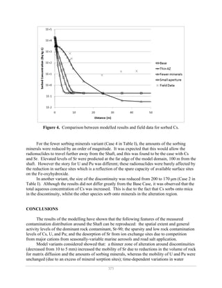
RESULTS AND DISCUSSION
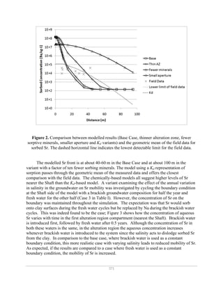
A comparison of the output of the modelling and field data for Sr is shown in Figure 2.
Since the field data are a compilation of data from the four different zones of contamination
around the Shaft, each with slightly different groundwater flow rates, discontinuity apertures,
mineralogical compositions, and physical properties (porosity and permeability), these data have
been represented as a geometric mean to reduce the inevitable scatter and variability due to the
sampling across different discontinuity zones.
The modelled peak value of Sr in the Base Case is 1E8 Bq/kg at the Shaft wall, decreasing
to 1E2 Bq/kg 50 m down-gradient of the Shaft. Measured Sr ranges up to about 1.0E6 Bq/kg,
but is mostly between 1E3 and 1E5 Bq/kg, and may extend 50-70 m from the Shaft (Figure 2).](https://image.slidesharecdn.com/4886a533-e87f-4132-a55a-15a859c9401e-161007145630/85/MRS_Dounreay_paper-4-320.jpg)
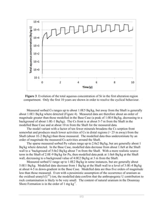
![374
chemistry (fresh alternated with brackish water on an annual basis) served to increase the
mobility of Sr relative to fresh water alone (an approximate 50 % increase in spatial extent over
50 years); and fewer sorbing minerals (by a factor of 10) increased the mobility of Sr and Cs,
whereas the mobility of U and Pu were unchanged due to an excess of mineral sorption sites. A
smaller discontinuity aperture (decreased from 250 to 170 µm) did not produce results
dramatically different from the base case, but aqueous concentrations of Cs were increased (due
to preferential sorption of Cs on the discontinuity surface itself, rather than in the alteration
zone). A lower source-term concentration for Pu (2.0E-9, reduced from 2.0E-7 mol l-1
) produced
lower, and more realistic activities of Pu sorbed in the geosphere.
The Kd model of sorption produced a good fit to the field data, increasing confidence in the
use of this assumption in larger-scale performance assessment modelling. The adoption of a
mechanistic model, rather than a Kd-based approach highlights that: activities of contaminants at
or near the Shaft wall could be much greater than a Kd approach would suggest, and activities in
more distal regions could be higher; contaminants sorbed by reversible ion exchange (e.g. Sr),
show that time-dependent variations in water chemistry can affect distributions of contamination
through competitive sorption effects; and uncertainties regarding the abundances of sorption-
active minerals can affect predicted patterns of contamination through consideration of
‘saturation’ of sorption sites in chemical models, which is not considered in the Kd approach.
ACKNOWLEDGMENTS
Funding from Dounreay Site Restoration Limited is gratefully acknowledged.
REFERENCES
[1] N.L. Jefferies, T.R. Lineham, M.C. Manning et al., Nirex Report No. NSS/R305, 2001.
[2] J.P. McKinley, J.M. Zachara, S.C. Smith et al., Geochim. Cosmochim. Acta 71, 305
(2007).
[3] C.A.J. Appelo and D. Postma, Geochemistry, Groundwater and Pollution. (A.A.
Balkema, Rotterdam, 1994).
[4] M.H. Bradbury and B. Baeyens, J. Contam. Hydrol. 42, 141 (2000).
[5] M. Zavarin and C.J. Bruton, LLNL Report No. UCRL-TR-208673, 2004.](https://image.slidesharecdn.com/4886a533-e87f-4132-a55a-15a859c9401e-161007145630/85/MRS_Dounreay_paper-8-320.jpg)


