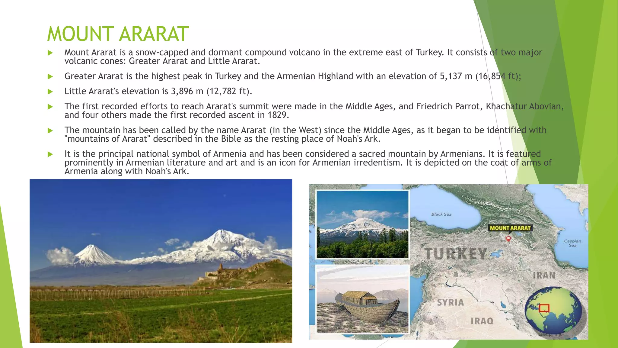
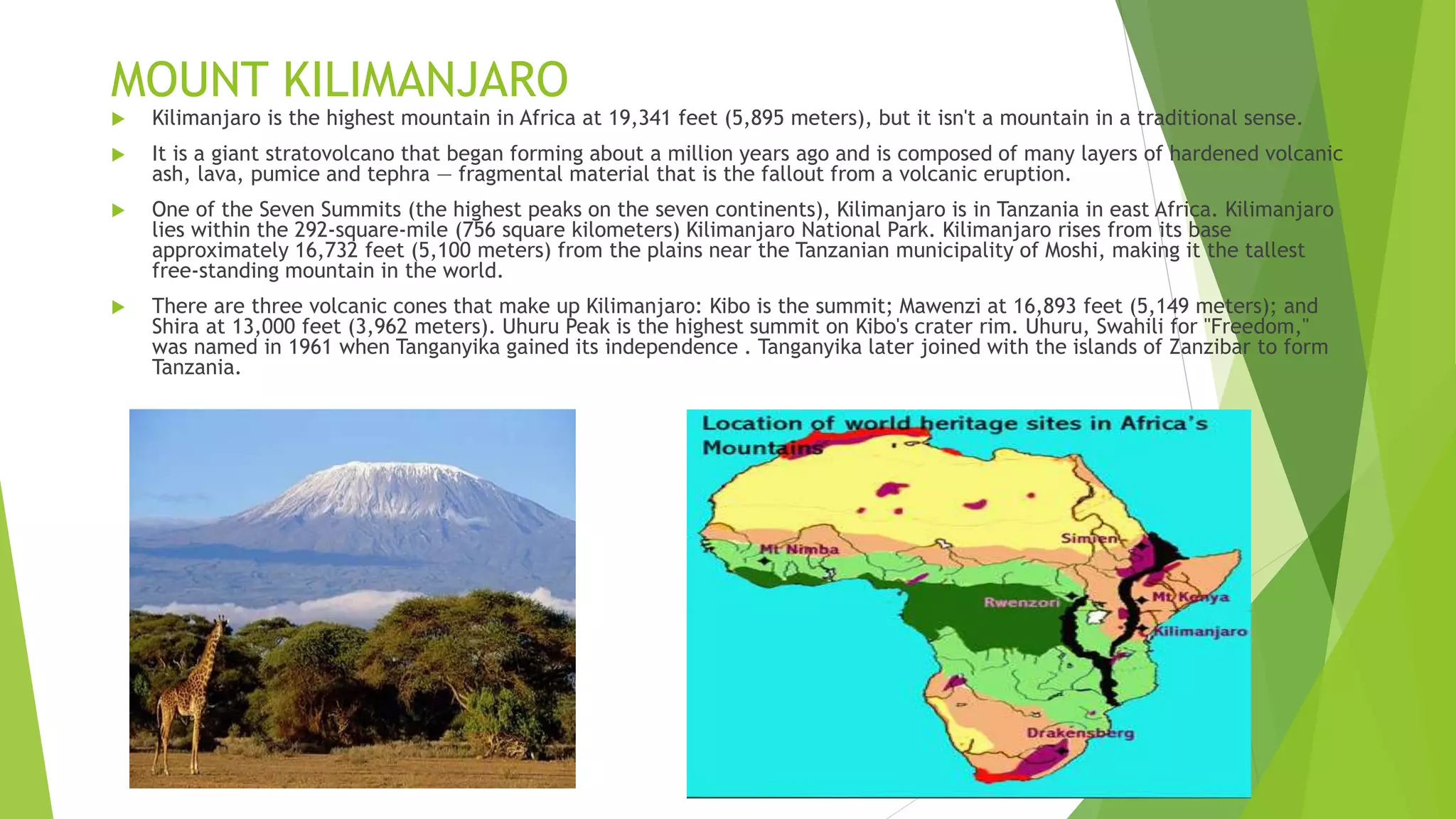
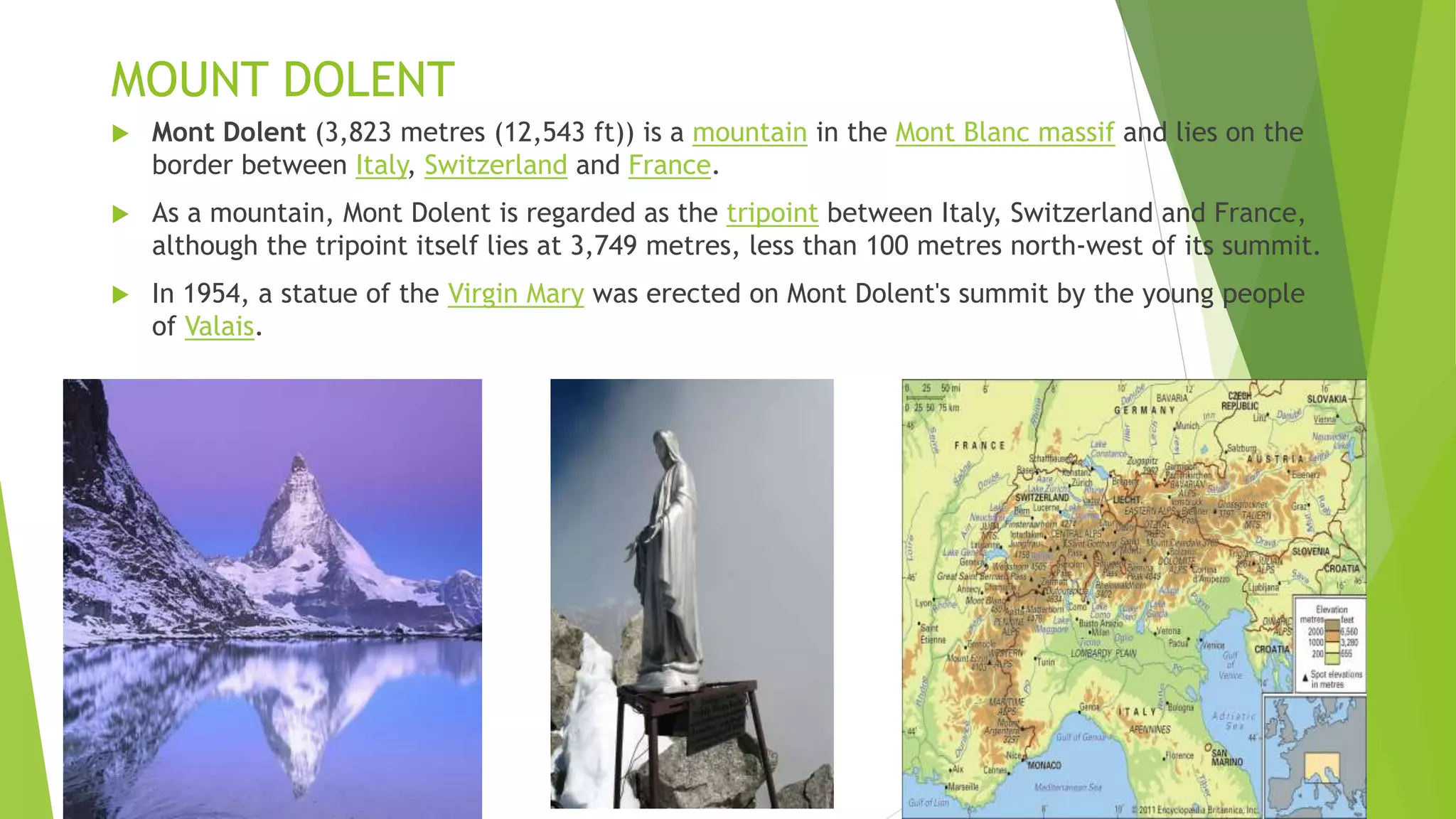
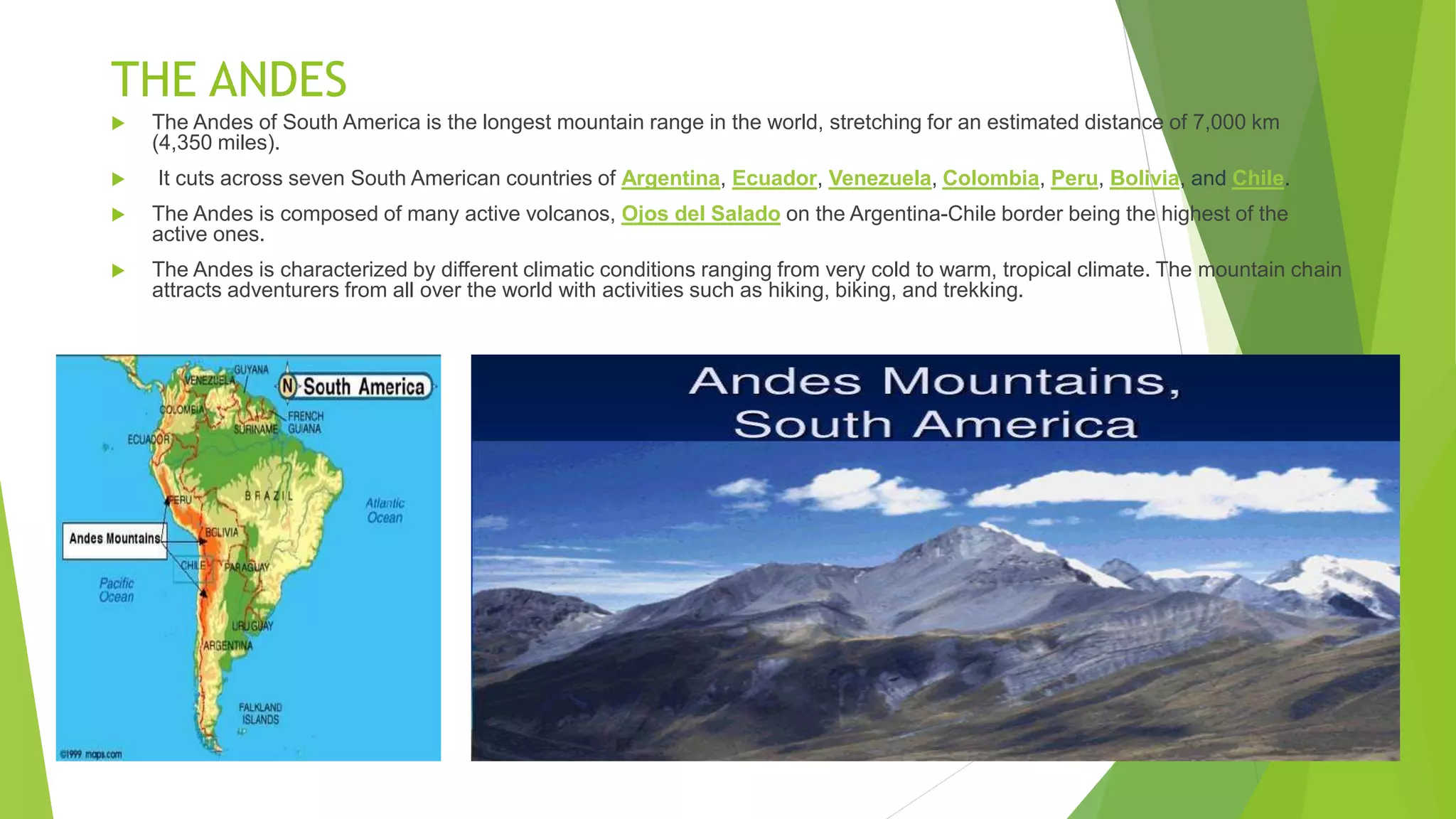
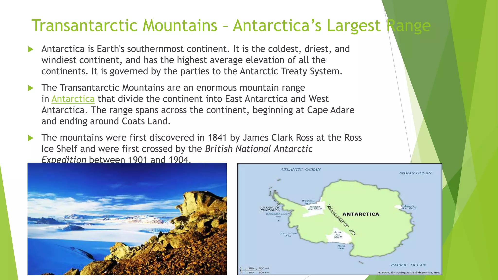
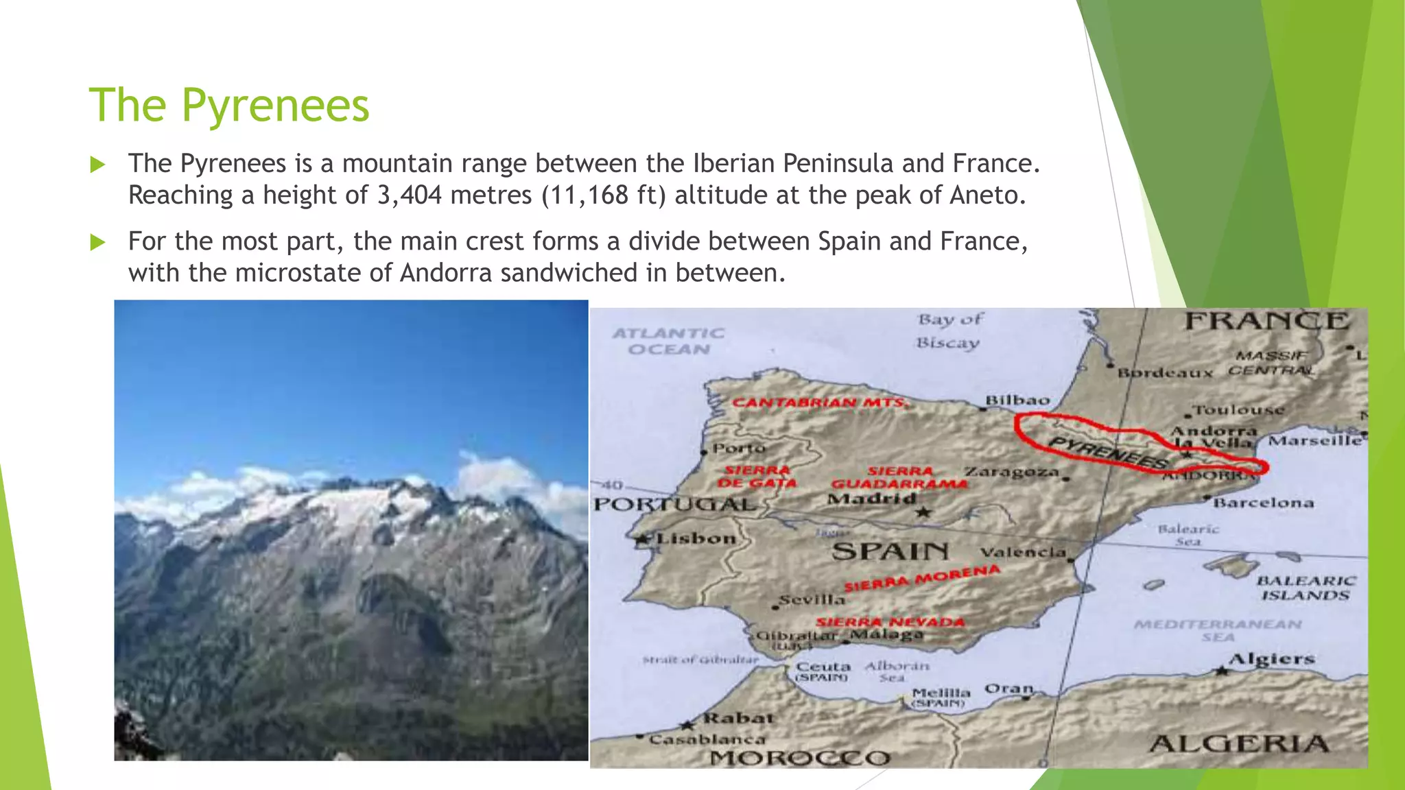
2. Test yourself
What is a mountain?
What is a mountain range?
How Are Mountains Formed?
What is a peak?
What are glaciers?
What is ice sheet ?
3. Answers
A mountain is a large landform that rises above the surrounding land in a limited area, usually
in the form of a peak. A mountain is generally steeper than a hill. Mountains are formed
through tectonic forces or volcanism. These forces can locally raise the surface of the earth.
A mountain range is a series or chain of mountains that are close together.
The world's tallest mountain ranges form when pieces of Earth's crust—called plates—smash
against each other in a process called plate tectonics and the mountains are formed.
The top or extreme point of something (usually a mountain or hill).
A glacier is a thick mass of ice that covers a large area of land. Around ten percent of the
world's land area is covered by glaciers. Most glaciers are located near the North or South
Poles, but glaciers also exist high in mountain ranges such as the Himalayas and the Andes.
An ice sheet is a mass of glacial ice more than 50,000 square kilometers (19,000 square
miles). Ice sheets contain about 99% of the freshwater on Earth, and are sometimes called
continental glacier s. As ice sheets extend to the coast and over the ocean, they become ice
shelves. Two great ice masses, the Antarctic and Greenland ice sheets, stand out in the world
today.
5. MOUNT ARARAT
Mount Ararat is a snow-capped and dormant compound volcano in the extreme east of Turkey. It consists of two major
volcanic cones: Greater Ararat and Little Ararat.
Greater Ararat is the highest peak in Turkey and the Armenian Highland with an elevation of 5,137 m (16,854 ft);
Little Ararat's elevation is 3,896 m (12,782 ft).
The first recorded efforts to reach Ararat's summit were made in the Middle Ages, and Friedrich Parrot, Khachatur Abovian,
and four others made the first recorded ascent in 1829.
The mountain has been called by the name Ararat (in the West) since the Middle Ages, as it began to be identified with
"mountains of Ararat" described in the Bible as the resting place of Noah's Ark.
It is the principal national symbol of Armenia and has been considered a sacred mountain by Armenians. It is featured
prominently in Armenian literature and art and is an icon for Armenian irredentism. It is depicted on the coat of arms of
Armenia along with Noah's Ark.
6. MOUNT KILIMANJARO
Kilimanjaro is the highest mountain in Africa at 19,341 feet (5,895 meters), but it isn't a mountain in a traditional sense.
It is a giant stratovolcano that began forming about a million years ago and is composed of many layers of hardened volcanic
ash, lava, pumice and tephra — fragmental material that is the fallout from a volcanic eruption.
One of the Seven Summits (the highest peaks on the seven continents), Kilimanjaro is in Tanzania in east Africa. Kilimanjaro
lies within the 292-square-mile (756 square kilometers) Kilimanjaro National Park. Kilimanjaro rises from its base
approximately 16,732 feet (5,100 meters) from the plains near the Tanzanian municipality of Moshi, making it the tallest
free-standing mountain in the world.
There are three volcanic cones that make up Kilimanjaro: Kibo is the summit; Mawenzi at 16,893 feet (5,149 meters); and
Shira at 13,000 feet (3,962 meters). Uhuru Peak is the highest summit on Kibo's crater rim. Uhuru, Swahili for "Freedom,"
was named in 1961 when Tanganyika gained its independence . Tanganyika later joined with the islands of Zanzibar to form
Tanzania.
7. MOUNT DOLENT
Mont Dolent (3,823 metres (12,543 ft)) is a mountain in the Mont Blanc massif and lies on the
border between Italy, Switzerland and France.
As a mountain, Mont Dolent is regarded as the tripoint between Italy, Switzerland and France,
although the tripoint itself lies at 3,749 metres, less than 100 metres north-west of its summit.
In 1954, a statue of the Virgin Mary was erected on Mont Dolent's summit by the young people
of Valais.
8. THE ANDES
The Andes of South America is the longest mountain range in the world, stretching for an estimated distance of 7,000 km
(4,350 miles).
It cuts across seven South American countries of Argentina, Ecuador, Venezuela, Colombia, Peru, Bolivia, and Chile.
The Andes is composed of many active volcanos, Ojos del Salado on the Argentina-Chile border being the highest of the
active ones.
The Andes is characterized by different climatic conditions ranging from very cold to warm, tropical climate. The mountain chain
attracts adventurers from all over the world with activities such as hiking, biking, and trekking.
9. KHYBER PASS
• The Khyber Pass is a mountain pass in the Khyber Pakhtunkhwa province of Pakistan, on the
border with Afghanistan (Nangarhar Province).
• It connects the town of Landi Kotal to the Valley of Peshawar at Jamrud by traversing part of
the Spin Ghar mountains. An integral part of the ancient Silk Road, it has long had substantial
cultural, economic, and geopolitical significance for Eurasian trade.
• Throughout history, it has been an important trade route between Central Asia and the Indian
subcontinent and a vital strategic military choke point for various states that came to control it.
• The summit of the pass is 5 km (3.1 mi) inside Pakistan at Landi Kotal, while the lowest point is at
Jamrud in the Valley of Peshawar. The Khyber Pass is part of Asian Highway 1.
The Khyber Pass with the
fortress of Ali Masjid in 1848
The Khyber Pass
Bab-e-Khyber (Pashto and Urdu: خیبر باب ;
" Khyber Gate")[1] is a
monument which stands at the entrance of the Khyber Pass in
the Khyber Pakhtunkhwa province of Pakistan. The gate is
immediately west of Peshawar, while the historic Jamrud Fort is
adjacent to the gate.[1]
Jamrud Fort
10. Transantarctic Mountains – Antarctica’s Largest Range
Antarctica is Earth's southernmost continent. It is the coldest, driest, and
windiest continent, and has the highest average elevation of all the
continents. It is governed by the parties to the Antarctic Treaty System.
The Transantarctic Mountains are an enormous mountain range
in Antarctica that divide the continent into East Antarctica and West
Antarctica. The range spans across the continent, beginning at Cape Adare
and ending around Coats Land.
The mountains were first discovered in 1841 by James Clark Ross at the Ross
Ice Shelf and were first crossed by the British National Antarctic
Expedition between 1901 and 1904.
11. Queen Maud Mountains
The Queen Maud Mountains is a large region of the Transantarctic Mountains and is comprised of
many different ranges, mountains and features such as glaciers, hills, bluffs and spurs. This
region is located between the Beardmore Glacier and the Reedy Glacier, and also includes the
area from the top of the Ross Ice Shelf to the Antarctic Plateau.
This enormous group of mountain ranges in the Transantarctic Mountains was named after Maud
of Wales, Queen of Norway, but contrary to its name, the region is not located in the Queen Maud
Land region of Antarctica.
12. The Pyrenees
The Pyrenees is a mountain range between the Iberian Peninsula and France.
Reaching a height of 3,404 metres (11,168 ft) altitude at the peak of Aneto.
For the most part, the main crest forms a divide between Spain and France,
with the microstate of Andorra sandwiched in between.
13. Mount Fuji,JAPAN
It is a volcano that has been dormant since its last eruption, in 1707, but is
still generally classified as active by geologists.
The mountain is the major feature of Fuji-Hakone-Izu National Park (1936),
and it is at the centre of a UNESCO World Heritage site designated in 2013.
14. URAL MOUNTAINS
The Ural Mountains are a mountain range that runs approximately from north to south through western Russia,
from the coast of the Arctic Ocean to the river Ural and northwestern Kazakhstan.[1] The mountain range forms
part of the conventional boundary between the continents of Europe and Asia. Vaygach Island and the islands of
Novaya Zemlya form a further continuation of the chain to the north into the Arctic Ocean.
The mountains lie within the Ural geographical region and significantly overlap with the Ural Federal District and
with the Ural economic region. They have rich resources, including metal ores, coal, and precious and semi-
precious stones. Since the 18th century the mountains have contributed significantly to the mineral sector of the
Russian economy.
15. K2 – KARAKORAM RANGE
K2, at 8,611 metres (28,251 ft) above sea level, is the second highest mountain in the world,
after Mount Everest at 8,848 metres (29,029 ft).
It is located on the China–Pakistan border between Baltistan in the Gilgit-Baltistan region of northern
Pakistan, and Dafdar Township[3] in Taxkorgan Tajik Autonomous County of Xinjiang, China.
K2 is the highest point of the Karakoram range and the highest point in both Pakistan and Xinjiang.
K2 is known as the Savage Mountain after George Bell, a climber on the 1953 American Expedition,
told reporters "It's a savage mountain that tries to kill you."[5] Of the five highest mountains in the
world, K2 is the deadliest where approximately one person dies on the mountain for every four who
reach the summit.[