Download to read offline

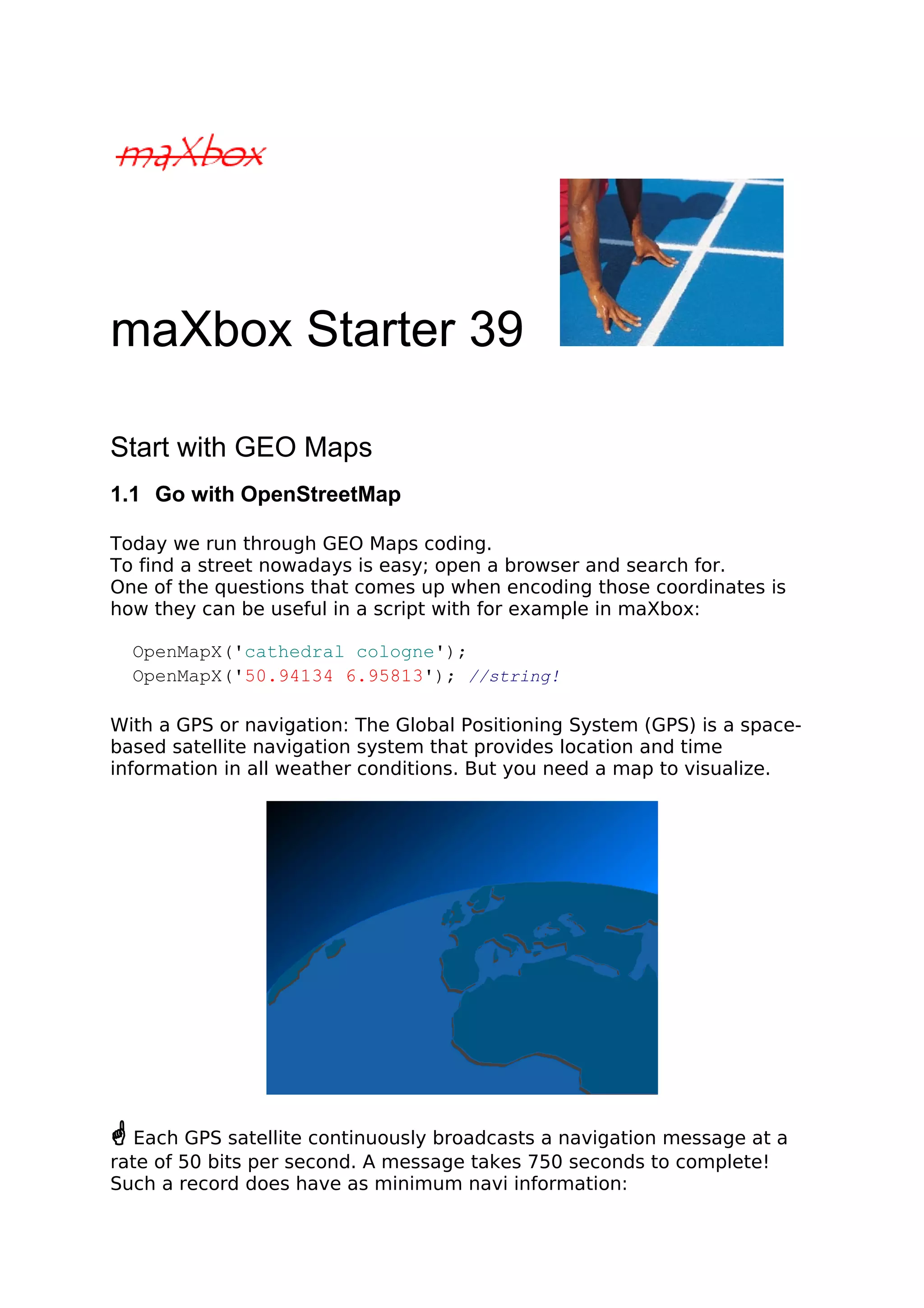
![procedure GPSRecord
begin
writeln('time,date,latitude,longitude,altitude,nsat,speed,course');
end
This isn't very different from a normal weather station clock, isn't it? Now
we define our map search to get the map in your standard browser. We
use the mapquest API from:
http://open.mapquestapi.com/nominatim/
The following example demonstrates a simple map search request for
“Cathedral Cologne“ using the Nominatim quest. Only three parameters
are being requested (menu: ViewGEO Map View):
1. format - Output format being called. [html/json/xml]
2. json_callback - Callback function used to display results below.
3. q - Query string being searched for.
We set first a const in the script to send the request:
Const
AMAPFILENAME2= 'maxmapfile.html';
UrlMapQuestAPICode2='http://open.mapquestapi.com/nominatim/v1/search
.php?format=%s&json_callback=renderBasicSearchNarrative&q=%s';
How are these 3 arguments linked together:
• format=%s
• json_callback=renderBasicSearchNarrative
• q=%s
You'll notice that the json_callback parameter is already set. The format
and the query string indeed is up to you. We use a html format to prepare
open a browser with the map, se here's the call:
if GetMAPX('html',ExePath+'cologne2mapX.html','cathedral cologne')
then writeln('Cologne Map found');
By the way: Most of GPS and data formats is found by the NMEA.
The NMEA is the National Marine Electronics Association. It is to be a
worldwide, self-sustaining organization committed to enhancing the
technology and safety of electronics used in marine applications and you
see also a standard for GPS data formats.
How it works: The GPS satellites transmit signals to a GPS receiver. These
receivers passively receive those signals; they do not transmit and require
a clear view of the sky, so they can only be used effectively outdoors, or
from time to time in trains or gadgets;-).
2](https://image.slidesharecdn.com/maxboxstarter39-140922150621-phpapp01/85/maXbox-Starter-39-GEO-Maps-Tutorial-2-320.jpg)
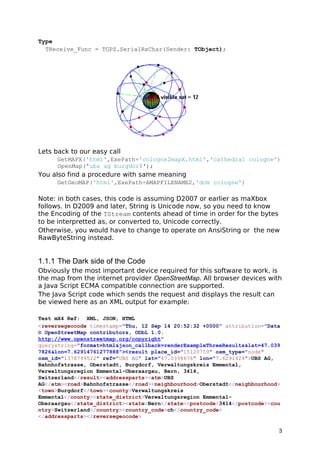
![From the result let's go back to the code behind.
As you already know the tool is split up into the toolbar across the top, the
editor or code part in the centre and the output window at the bottom.
Change that in the menu /view at our own style.
Before this starter code will work you will need to download maXbox
from a website. You'll get it from
http://www.softwareschule.ch/maxbox.htm . Once the download has
finished, unzip the file, making sure that you preserve the folder structure
as it is. Test it with F9 / F2 or press Compile and you should hear a test
sound. So far so good now we’ll open the examples:
509_GEOMap3.txt
If you can’t find the two files try also direct as a file
http://www.softwareschule.ch/examples/509_GEOMap3.txt
Now let’s take a look at the code of this app. One of our first line is
creating the object mapStream and the encoded URL we use first methods
to configure our HTTPGet() calling Port and IP of the mapquest API with the
help of HTTPEncode. The object makes a bind connection with the Active
method by passing an encoded URL with a memory stream:
procedure GetMapScript(C_form,apath: string; const Data:string);
var encURL: string;
mapStream: TMemoryStream;
begin
encURL:= Format(UrlMapQuestAPICode2, [c_form,HTTPEncode(Data)]);
mapStream:= TMemoryStream.create;
try
HttpGet(EncURL, mapStream); //WinInet
mapStream.Position:= 0;
mapStream.Savetofile(apath)
OpenDoc(apath);
finally
mapStream.Free;
end;
end;
The OpenDoc() procedure is used to get a browser open, you remember
the call above:
GetMAPScript('html',ExePath+'cologne2mapX.html',
'cathedral cologne')
As we decode this with Format like above:
• format=html
• json_callback=renderBasicSearchNarrative
• q=cathedral cologne
And this is how another function with download works:
4](https://image.slidesharecdn.com/maxboxstarter39-140922150621-phpapp01/85/maXbox-Starter-39-GEO-Maps-Tutorial-4-320.jpg)
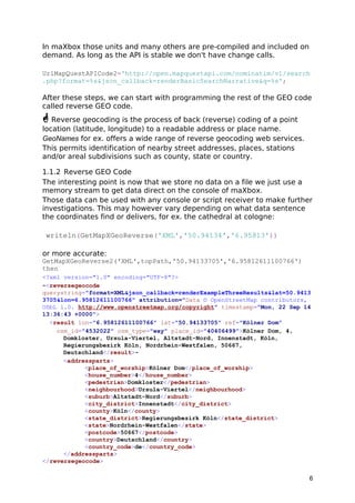
![function GetMapXScript(C_form,apath: string; const Data: string): boolean;
var encodedURL: string;
begin
encodedURL:= Format(UrlMapQuestAPICode2,[c_form,HTTPEncode(Data)]);
try
//instead HttpGet(EncodedURL, mapStream); //WinInet
Result:= UrlDownloadToFile(Nil,PChar(encodedURL),PChar(apath),0,Nil)= 0;
OpenDoc(apath);
finally
encodedURL:= '';
end;
end;
This function is shorter than the first one because we use no streams in
between. Working with streams in Free Pascal or Delphi you have to
include some units to be able to use or code your functions direct in the
script as you like:
function DownloadFile(SourceFile, DestFile: string): Boolean;
begin
//TCIPStatus TBindStatus TURLTemplate of URLMon
try
Result:=
UrlDownloadToFile(Nil,PChar(SourceFile),PChar(DestFile),0,Nil)= 0;
except
Result:= False;
end;
end;
5](https://image.slidesharecdn.com/maxboxstarter39-140922150621-phpapp01/85/maXbox-Starter-39-GEO-Maps-Tutorial-5-320.jpg)
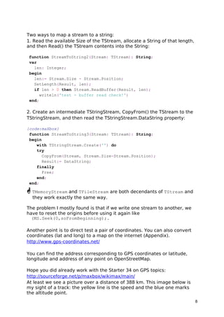
![Reverse geocoding can be carried out systematically by services which
process a coordinate similarly to a geocoding process.
For ex., when a GPS coordinate is entered the street address is interpol-ated
from a range assigned to the road segment in a reference dataset
that the point is nearest to.
osm_id="4532022" osm_type="way" place_id="40406499">Kölner Dom, 4,
Domkloster, Ursula-Viertel, Altstadt-Nord, Innenstadt, Köln,
Regierungsbezirk Köln, Nordrhein-Westfalen, 50667,
Deutschland</result>-
Each table has a way column containing the geometry for the object in
the chosen projection. Two indices are created for each table: one for the
way column and one for the osm_id column, see above.
Geometry uses coordinates in the EPSG:900913 AKA G00GlE projection
and can be easily used in e.g. OpenLayers based JavaScript.
Now for the code behind the call. We need another mapquest API of the get
request service:
UrlMapQuestAPI3:= 'http://open.mapquestapi.com/nominatim/v1/reverse.php?
format=%s&json_callback=renderExampleThreeResults&lat=%s&lon=%s';
As you can see it's a PHP server side service:
encodedURL:
http://open.mapquestapi.com/nominatim/v1/reverse.php?
The function maps a stream to a string and is similar to above, except we
don't save a file, but you can save the stream as an XML or Json file:
mapstream.savetofile(apath) and OpenDoc(apath);
function GetMapXGeoReverse2(C_form,apath: string; const lat,long:
string):boolean;
var encodedURL, UrlMapQuestAPI, bufstr: string;
mapStream: TMemoryStream;
begin
UrlMapQuestAPI:= 'http://open.mapquestapi.com/nominatim/v1/reverse.php?
format=%s&json_callback=renderExampleThreeResults&lat=%s&lon=%s';
encodedURL:= Format(UrlMapQuestAPI,[c_form, lat, long]);
mapStream:= TMemoryStream.create;
try
HttpGet(EncodedURL, mapStream); {WinInet}
mapStream.Position:= 0;
writeln('stream size: '+inttostr(mapstream.size)); //mapStream.memory;
bufstr:= StreamToString(mapstream);
writeln('stream back: '+bufstr)
finally
encodedURL:= '';
mapStream.Free;
end;
end;
7](https://image.slidesharecdn.com/maxboxstarter39-140922150621-phpapp01/85/maXbox-Starter-39-GEO-Maps-Tutorial-7-320.jpg)

The document provides detailed instructions on how to use the maxbox software with geo maps, integrating OpenStreetMap for GPS functionalities. It covers both geocoding and reverse geocoding processes using the MapQuest API, demonstrating how to retrieve location information based on coordinates. Additionally, it discusses technical aspects of handling data streams within the software environment, including examples of code to implement these functions.