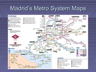
Madrid’s Metro System Maps
KEYFACTS
 Started operating in 1919 (King Alfonso XIII)
      Oldest: London (1863)
   # Lines: 13 (1st NYC with 26)
   # Stations: 231 (5th, 1st NYC with 422)
   Length: 283 Km (3rd, 1st London with 408)
   Total Passengers (2007): 690 millions
    (14th , 1st Tokyo with 1916 millions)
 Has grown from 114 Km in 1995 to 283 Km in 2007
    (169 New Km in 12 years ~ 14,1 New Km/Year)
Table of Comparison
                   “Old” Map    New Map

   Respects
                     Yes           No
   distances

Sense of reality     Good         Bad

 Ease of use         Good      ¿Very? Good

 Appearence          Nice        ¿Nicer?
Who’s behind the maps?
 “Old” Map:                  New Map:


 Comunidad de Madrid
  & CTM
                                Rafael Sañudo
(consejeria de transportes
e infraeestructuras)
Questions

 Who is the author?
 What kind of map is it?
 What is the map’s purpose?
 Who is the audience?
 Is it possible to misinterpret the map?
 What may improve the map?
QUESTIONS FOR THE CLASS

 What may improve (an underground
 network) map?

 What makes a good (underground
 network) map?
Links & Sources
 http://www.20minutos.es/noticia/224418/0/plano/metro/debate/ (new
  map article)
 http://www.skyscrapercity.com/showthread.php?t=463947 (survey #1)
 http://www.20minutos.es/minuteca/metro-de-madrid/ (survey #2)
 http://urbanity.blogsome.com/2005/12/30/metro-de-madrid-evolucion-historica/
   (evolution of the network)
 http://www.esmuz.net/blog/2005/01/el-plano-de-metro.html (subway’s
  maps from the point of view of a graphic designer)
 http://www.20minutos.es/galeria/2347/0/0/ (photogallery)
 http://en.wikipedia.org/wiki/Harry_Beck_(graphic_designer)
 http://www.20minutos.es/noticia/224865/0/nuevo/mapa/metro/ (Madrid’s
  new metro map designer)
 http://www.raro.net/ (Madrid’s new metro map designer’s website)
 http://www.new.facebook.com/profile.php?
   id=517815832&ref=mf#/group.php?gid=25126229252 (Facebook group
   agains the new map)

Madrid’s metro system map (2008)

  • 1.
  • 2.
    KEYFACTS  Started operatingin 1919 (King Alfonso XIII)  Oldest: London (1863)  # Lines: 13 (1st NYC with 26)  # Stations: 231 (5th, 1st NYC with 422)  Length: 283 Km (3rd, 1st London with 408)  Total Passengers (2007): 690 millions (14th , 1st Tokyo with 1916 millions)  Has grown from 114 Km in 1995 to 283 Km in 2007 (169 New Km in 12 years ~ 14,1 New Km/Year)
  • 3.
    Table of Comparison “Old” Map New Map Respects Yes No distances Sense of reality Good Bad Ease of use Good ¿Very? Good Appearence Nice ¿Nicer?
  • 4.
    Who’s behind themaps?  “Old” Map:  New Map:  Comunidad de Madrid & CTM Rafael Sañudo (consejeria de transportes e infraeestructuras)
  • 5.
    Questions  Who isthe author?  What kind of map is it?  What is the map’s purpose?  Who is the audience?  Is it possible to misinterpret the map?  What may improve the map?
  • 6.
    QUESTIONS FOR THECLASS  What may improve (an underground network) map?  What makes a good (underground network) map?
  • 7.
    Links & Sources http://www.20minutos.es/noticia/224418/0/plano/metro/debate/ (new map article)  http://www.skyscrapercity.com/showthread.php?t=463947 (survey #1)  http://www.20minutos.es/minuteca/metro-de-madrid/ (survey #2)  http://urbanity.blogsome.com/2005/12/30/metro-de-madrid-evolucion-historica/ (evolution of the network)  http://www.esmuz.net/blog/2005/01/el-plano-de-metro.html (subway’s maps from the point of view of a graphic designer)  http://www.20minutos.es/galeria/2347/0/0/ (photogallery)  http://en.wikipedia.org/wiki/Harry_Beck_(graphic_designer)  http://www.20minutos.es/noticia/224865/0/nuevo/mapa/metro/ (Madrid’s new metro map designer)  http://www.raro.net/ (Madrid’s new metro map designer’s website)  http://www.new.facebook.com/profile.php? id=517815832&ref=mf#/group.php?gid=25126229252 (Facebook group agains the new map)