Atlanta's electric car routes, 1928
•Download as PPTX, PDF•
0 likes•220 views
This is the beginning of a map that will trace electric car routes in Atlanta on a 1928 map of the city and hyperlink information about the routes (including pictures, ownership information, descriptions and trivia) to their line drawings.
Report
Share
Report
Share

Recommended
Database Camp 2016 @ United Nations, NYC - Javier de la Torre, CEO, CARTO
This document discusses location intelligence and geospatial databases. It provides examples of how analyzing location data can help predict walking paths, populations affected by transportation changes, poverty levels, and business opportunities for ridesharing companies. The document promotes CARTO as an open and powerful platform for discovering insights from location data and lists industries that generate large amounts of location data like telecom, banks, utilities, and health. It envisions high performance analytics on geospatial databases and notes CARTO is hiring.
Integration of Land Use & Transportation Planning in the SMART Plan
Integration of Land Use & Transportation Planning in the SMART PlanMiami-Dade Transportation Planning Organization
This document summarizes the Miami-Dade SMART Plan, which plans for six rapid transit corridors in Miami-Dade County. It involved analyzing existing land uses, developing land use and transit scenarios, forecasting ridership, and selecting a preferred scenario. The process included public engagement, analyzed impacts of transit-oriented development, and made policy recommendations to encourage land use patterns that support the transit system. The key goal was to integrate land use and transportation planning to create a more sustainable transportation network.The 2028 Olympics: A Catalyst for Los Angeles’s Transportation Improvements a...
This document discusses how Los Angeles' hosting of the 2028 Olympics can help accelerate the city's transportation improvements and sustainability goals. It outlines LA's plans to expand transit networks like metro lines and bike lanes, electrify transportation, and reduce emissions. Previous Olympic cities like Los Angeles in 1984, Beijing in 2008, and Vancouver in 2010 saw benefits like decreased driving and increased use of sustainable transit from hosting the games. LA aims to similarly leverage the 2028 Olympics to combat auto dependence and make progress on its sustainability targets.
Connections
This is my Spring 2015 studio project. The 2nd Year Foundation Studio focused on developing an existing parking lot for UVa's sports facilities into a mixed use student housing area. My project focused on creating spaces for interaction between students and fans at the center of game day activity.
Front-end up front
Aleksandra Hristova's presentation at JavaSkop 2019.
Topics touched:
- Using pattern libraries to improve the communication between designers and developers and the importance of including the whole team and the client into the planning phase.
- How to plan and build components that can be used in different contexts and within other components with examples from real projects.
- How we have used UX design principles to ease our front-end implementations with code examples using the latest CSS features and Angular.
Who needs giant roads? Donwgrade of big infrastructures and Ufa street network
This document discusses the degradation of infrastructure and street networks in Ufa, Russia. It notes that historically, organized street layouts and interconnectivity have been important for successful urban development. Research from the UN and University College London finds that more accessible and connected cities are more livable, socially integrated, and economically dynamic. However, streets are now mainly seen as links for travel rather than public spaces. The document argues for prioritizing accessibility, proximity, and connectivity over just mobility to create more sustainable transportation. It focuses on applying these ideas to the specific city of Ufa.
高速道路で発生する事象の情報体系化に関する検討
In Japan, some traffic event is displayed by the graphic symbol with letters on expressway VMS. However,
drivers are difficult to comprehend some of them. In order to solve the current situation, we investigated the referent characteristics based on the idea that the suitable referent was needed for the graphic symbol to transmit the message appropriately. We searched for the systematic grasping method using the semantic distance about the concept of road information and the relation among concepts through drivers’ analogizing images related event names as a referent. Through these processes, in order to establish the referent of a graphic symbol, we showed that it was possible to systematize with arranging the causal relationship in the context, and that it is important to grasp structurally the causal relationship of the information related traffic event.
Mapping urban data (Urbica Design)
The keynote for Open GIS conference in Moscow. 22 November 2015. The projects by Urbica Design (see http://urbica.co)
Urbica Design showcases (may 2016)
Urbica is a design firm based in Moscow that focuses on human experience design in cities. They conduct user experience research, information design, spatial data analysis, and urban planning. Their approach involves prototyping and getting user feedback. Some of their projects include designing maps for MAPS.ME, analyzing bike rental data for the Moscow Department of Transport, studying New York City's bike share rebalancing system, and researching pedestrian conditions in Moscow.
Bordeaux tramway. Service effectiveness and Urban integration, an example th...
This document summarizes a presentation given in Ufa, Russia on November 20, 2015 about the tram system in Bordeaux, France and its lessons for Ufa. It describes how Bordeaux developed an extensive tram network with 3 lines after abandoning trams in the 1940s. The network integrated public transportation, reduced car traffic and emissions, and increased accessibility. The document suggests Ufa could develop a similar 50km tram network along major roads to improve its public transportation system before car ownership increases further and locks in unsustainable transportation patterns.
Georeferencing
Linear referencing is a method for locating geographic locations by measuring their position along a linear feature, such as a road or river. Locations are measured by distance from a reference point. This allows events and features to be dynamically located as attributes change without splitting the linear feature. Linear referencing is used for applications like tracking traffic accidents, managing road and railway infrastructure, monitoring utilities like pipelines, and locating objects in hydrology applications along rivers.
Screen line and Corrider Line Analysis
This document discusses urban transportation systems, including corridor screen line analysis, urban forms and structures, and classification of urban roads. It defines a screen line as an imaginary line splitting an area in two for traffic analysis. It also describes various urban forms like finger, radial, and grid patterns determined by elements like land use, density, and transportation infrastructure. Furthermore, it classifies urban roads as arterial, sub-arterial, and local roads. Finally, it outlines different types of urban road systems such as gridiron, concentric and radial, and organic networks.
Managing Viennas Tram and Metro Network
1) Vienna's metro and tram network transported 939 million passengers in 2015 on 664 km of track with 8,759 employees.
2) Ridership is expected to grow to 1 billion by 2020 as Vienna's population grows from 30% urbanized in 1950 to an expected 70% in 2050.
3) The network is investing in modernizing its fleet and expanding routes to accommodate rising demand through 2030.
Osm josm os_mmaps
This document provides an overview of OpenStreetMap (OSM) and how to use the JOSM editor to contribute data to the OSM database. It explains that OSM is a database where geographic data is collected and uploaded. JOSM is used to describe elements like highways, buildings, and land use by adding tags with keys and values to nodes, ways, and relations. It also differentiates between editing in the database and rendering map styles from the database using software like Mapnik, which determines how elements appear on final maps.
Transport Modelling Workshop Software Innovation
The document provides an overview of PTV Group's transportation modeling software and services. It highlights capabilities like microscopic pedestrian simulation, large-scale network modeling, traffic impact analysis, real-time traffic simulation fused with real data, online traffic signal control, and shared mobility modeling. It also summarizes case studies applying the software for autonomous vehicle modeling, urban cycling planning, and bridge closure impact analysis.
RS Procurement Ebook
This document provides a step-by-step guide for public works organizations to assemble an effective Request for Proposal (RFP) for route optimization procurement. It outlines determining needs and key performance indicators, researching available solutions, defining project scope and costs, evaluating vendor proposals, and other important considerations like training and long-term objectives. The goal is to help organizations structure their procurement process to select the right route optimization solution and realize meaningful returns on their investment.
Shuttle Route Optimization for the Sector # H-12, Islamabad using GIS software
This document discusses a project to design a transportation network for a university campus. It includes the following:
- A list of group members and their roles in the project.
- An outline of the phases of the project, including analysis of the existing system, design of new routes, digitization of maps, and network analysis.
- Descriptions of the three proposed routes, including maps showing their layouts on the campus.
- Explanations of the processes involved in georectification, digitization, and network analysis.
- A map showing the results of network analysis for different transportation options.
- A timeline estimating two weeks for analysis, one week for design, and two to
Deepwater Horizon Oil Spill
A short slideshow to teach about what went wrong and how they tried to stop the leak. Made for 6-8 graders
Trimble Advanced Route Optimization Technology - QUANTM
The document describes Trimble's Quantm software for advanced route planning. It notes that conventional planning methods rely heavily on experience and are time-consuming, while Quantm uses optimization algorithms and large digital terrain models to automatically generate multiple cost-effective alignment alternatives in a fraction of the time. Case studies show Quantm helped reduce costs up to 30% and planning time by 50% for various large infrastructure projects around the world.
Route optimization
This document discusses route optimization for pest control companies. It addresses how routing impacts revenue and expenses, and in turn profitability. Labor is identified as the single largest expense, and there are two main ways technicians can be compensated - hourly rates or as a percentage of their route. Examples are provided to illustrate how fitting more work into the same time period increases profits by raising revenue and lowering the labor expense percentage. The key metric of utilization is introduced, which is a ratio of time spent working on jobs to total clocked in time, and how improving utilization can increase daily revenues.
Mengembangkan Kepercayaan Diri
Dokumen tersebut membahas beberapa hal yang berkaitan dengan kepercayaan diri (self confidence) seperti self efficacy, self esteem, serta beberapa tips untuk meningkatkan kepercayaan diri seperti berpakaian rapi, berjalan tegak, berolahraga secara teratur, serta fokus pada kontribusi yang diberikan kepada orang lain.
Wherecamp Navigation Conference 2015 - GraphHopper Route Optimization
GraphHopper provides routing and route optimization APIs. It was created in 2012 and combines open source routing software with algorithms to solve vehicle routing problems. The route optimization API finds least cost routes that visit multiple locations in a specified order, taking vehicle capacities into account. It uses various search algorithms like branch and bound to optimize routes for applications like deliveries. The route optimization editor allows interactive solving of traveling salesman, vehicle routing and other problems. Demonstrations of optimizing Dublin pub routes gained significant publicity for GraphHopper.
ThingTech - RouteIT Product Overview
RouteIT is a Schedule and Route Optimization solution that delivers real-time fleet management and enterprise system integration.
Ambuja Cement
The Gujarat Ambuja Cement Ltd. was established in 1986 in Vadnagar, India and began cement production later that year. It was originally planned to be located in Mahuva but relocated due to lack of cooperation. The company has since expanded to include two additional production plants and has an overall cement production capacity of 18.5 million tons annually, making it the most profitable cement company in India. A key part of its success is an emphasis on efficiency due to power costs representing 40% of cement production costs.
Memahami masalah dan perkembangan emosi pada anak
Dokumen tersebut membahas perkembangan emosi anak pada berbagai usia, mulai dari bayi hingga anak sekolah. Emosi dasar seperti senang, sedih, takut dan marah mulai muncul pada usia dini, dan seiring bertambahnya usia, emosi anak menjadi lebih kompleks. Dokumen juga menjelaskan pentingnya pengasuhan yang sensitif dan disiplin positif untuk membantu perkembangan emosi anak.
More Related Content
What's hot
Urbica Design showcases (may 2016)
Urbica is a design firm based in Moscow that focuses on human experience design in cities. They conduct user experience research, information design, spatial data analysis, and urban planning. Their approach involves prototyping and getting user feedback. Some of their projects include designing maps for MAPS.ME, analyzing bike rental data for the Moscow Department of Transport, studying New York City's bike share rebalancing system, and researching pedestrian conditions in Moscow.
Bordeaux tramway. Service effectiveness and Urban integration, an example th...
This document summarizes a presentation given in Ufa, Russia on November 20, 2015 about the tram system in Bordeaux, France and its lessons for Ufa. It describes how Bordeaux developed an extensive tram network with 3 lines after abandoning trams in the 1940s. The network integrated public transportation, reduced car traffic and emissions, and increased accessibility. The document suggests Ufa could develop a similar 50km tram network along major roads to improve its public transportation system before car ownership increases further and locks in unsustainable transportation patterns.
Georeferencing
Linear referencing is a method for locating geographic locations by measuring their position along a linear feature, such as a road or river. Locations are measured by distance from a reference point. This allows events and features to be dynamically located as attributes change without splitting the linear feature. Linear referencing is used for applications like tracking traffic accidents, managing road and railway infrastructure, monitoring utilities like pipelines, and locating objects in hydrology applications along rivers.
Screen line and Corrider Line Analysis
This document discusses urban transportation systems, including corridor screen line analysis, urban forms and structures, and classification of urban roads. It defines a screen line as an imaginary line splitting an area in two for traffic analysis. It also describes various urban forms like finger, radial, and grid patterns determined by elements like land use, density, and transportation infrastructure. Furthermore, it classifies urban roads as arterial, sub-arterial, and local roads. Finally, it outlines different types of urban road systems such as gridiron, concentric and radial, and organic networks.
Managing Viennas Tram and Metro Network
1) Vienna's metro and tram network transported 939 million passengers in 2015 on 664 km of track with 8,759 employees.
2) Ridership is expected to grow to 1 billion by 2020 as Vienna's population grows from 30% urbanized in 1950 to an expected 70% in 2050.
3) The network is investing in modernizing its fleet and expanding routes to accommodate rising demand through 2030.
Osm josm os_mmaps
This document provides an overview of OpenStreetMap (OSM) and how to use the JOSM editor to contribute data to the OSM database. It explains that OSM is a database where geographic data is collected and uploaded. JOSM is used to describe elements like highways, buildings, and land use by adding tags with keys and values to nodes, ways, and relations. It also differentiates between editing in the database and rendering map styles from the database using software like Mapnik, which determines how elements appear on final maps.
Transport Modelling Workshop Software Innovation
The document provides an overview of PTV Group's transportation modeling software and services. It highlights capabilities like microscopic pedestrian simulation, large-scale network modeling, traffic impact analysis, real-time traffic simulation fused with real data, online traffic signal control, and shared mobility modeling. It also summarizes case studies applying the software for autonomous vehicle modeling, urban cycling planning, and bridge closure impact analysis.
What's hot (7)
Bordeaux tramway. Service effectiveness and Urban integration, an example th...
Bordeaux tramway. Service effectiveness and Urban integration, an example th...
Viewers also liked
RS Procurement Ebook
This document provides a step-by-step guide for public works organizations to assemble an effective Request for Proposal (RFP) for route optimization procurement. It outlines determining needs and key performance indicators, researching available solutions, defining project scope and costs, evaluating vendor proposals, and other important considerations like training and long-term objectives. The goal is to help organizations structure their procurement process to select the right route optimization solution and realize meaningful returns on their investment.
Shuttle Route Optimization for the Sector # H-12, Islamabad using GIS software
This document discusses a project to design a transportation network for a university campus. It includes the following:
- A list of group members and their roles in the project.
- An outline of the phases of the project, including analysis of the existing system, design of new routes, digitization of maps, and network analysis.
- Descriptions of the three proposed routes, including maps showing their layouts on the campus.
- Explanations of the processes involved in georectification, digitization, and network analysis.
- A map showing the results of network analysis for different transportation options.
- A timeline estimating two weeks for analysis, one week for design, and two to
Deepwater Horizon Oil Spill
A short slideshow to teach about what went wrong and how they tried to stop the leak. Made for 6-8 graders
Trimble Advanced Route Optimization Technology - QUANTM
The document describes Trimble's Quantm software for advanced route planning. It notes that conventional planning methods rely heavily on experience and are time-consuming, while Quantm uses optimization algorithms and large digital terrain models to automatically generate multiple cost-effective alignment alternatives in a fraction of the time. Case studies show Quantm helped reduce costs up to 30% and planning time by 50% for various large infrastructure projects around the world.
Route optimization
This document discusses route optimization for pest control companies. It addresses how routing impacts revenue and expenses, and in turn profitability. Labor is identified as the single largest expense, and there are two main ways technicians can be compensated - hourly rates or as a percentage of their route. Examples are provided to illustrate how fitting more work into the same time period increases profits by raising revenue and lowering the labor expense percentage. The key metric of utilization is introduced, which is a ratio of time spent working on jobs to total clocked in time, and how improving utilization can increase daily revenues.
Mengembangkan Kepercayaan Diri
Dokumen tersebut membahas beberapa hal yang berkaitan dengan kepercayaan diri (self confidence) seperti self efficacy, self esteem, serta beberapa tips untuk meningkatkan kepercayaan diri seperti berpakaian rapi, berjalan tegak, berolahraga secara teratur, serta fokus pada kontribusi yang diberikan kepada orang lain.
Wherecamp Navigation Conference 2015 - GraphHopper Route Optimization
GraphHopper provides routing and route optimization APIs. It was created in 2012 and combines open source routing software with algorithms to solve vehicle routing problems. The route optimization API finds least cost routes that visit multiple locations in a specified order, taking vehicle capacities into account. It uses various search algorithms like branch and bound to optimize routes for applications like deliveries. The route optimization editor allows interactive solving of traveling salesman, vehicle routing and other problems. Demonstrations of optimizing Dublin pub routes gained significant publicity for GraphHopper.
ThingTech - RouteIT Product Overview
RouteIT is a Schedule and Route Optimization solution that delivers real-time fleet management and enterprise system integration.
Ambuja Cement
The Gujarat Ambuja Cement Ltd. was established in 1986 in Vadnagar, India and began cement production later that year. It was originally planned to be located in Mahuva but relocated due to lack of cooperation. The company has since expanded to include two additional production plants and has an overall cement production capacity of 18.5 million tons annually, making it the most profitable cement company in India. A key part of its success is an emphasis on efficiency due to power costs representing 40% of cement production costs.
Memahami masalah dan perkembangan emosi pada anak
Dokumen tersebut membahas perkembangan emosi anak pada berbagai usia, mulai dari bayi hingga anak sekolah. Emosi dasar seperti senang, sedih, takut dan marah mulai muncul pada usia dini, dan seiring bertambahnya usia, emosi anak menjadi lebih kompleks. Dokumen juga menjelaskan pentingnya pengasuhan yang sensitif dan disiplin positif untuk membantu perkembangan emosi anak.
Our Best Countries
Singapore, Qatar, Norway, and Switzerland were identified as some of the best economies based on an analysis. The group considered various criteria to evaluate and select these four countries that have strong and stable economic conditions.
Routes optimization
The document summarizes an optimization program that airlines can use to determine the right freight capacity, operating frequency, and fleet positioning to minimize costs and maximize profits. The program takes in data on routes, yields, demands, and costs. It then runs integer programming models and U-curve techniques to find the optimum solution. A case study on Yemenia airline shows how the program can determine the best aircraft types for its network and maximize profits on a multi-stop route from Sana'a to Singapore.
Route Optimization Algorithm..
Route optimization algorithm are the mathematical formula that solve routing problems..
Some types of routing:
1) Vehicle Routing Problem (VRP)
2) Traveling Salesman Problem (TSP)
3) Ant Colony Optimization (ACO)
Etika dan pengembangan sikap positif
Dokumen tersebut membahas tentang etika dan pengembangan sikap positif. Etika merujuk pada adat istiadat atau kebiasaan yang baik secara turun temurun, sedangkan etiket merujuk pada norma sopan santun. Dokumen juga menjelaskan pentingnya penerapan etika dan etiket dalam pergaulan serta bisnis, serta bagaimana mengembangkan sikap positif dan menghindari sikap negatif.
Ambuja Cements Ltd. Internship Project Presentation
Subharaj Chakraborty completed a summer internship project assessing mining operations at Ambuja Cements Ltd.'s Kashlog limestone mine. Key findings included the crusher operating below capacity and inconsistent dumper cycle times due to idling. Suggestions focused on minimizing idle time through optimizing dumper-excavator ratios and enforcing safety procedures like proper personal protective equipment usage and speed limits. The internship provided insights into improving mining efficiency and safety practices.
Viewers also liked (20)
Shuttle Route Optimization for the Sector # H-12, Islamabad using GIS software
Shuttle Route Optimization for the Sector # H-12, Islamabad using GIS software
Trimble Advanced Route Optimization Technology - QUANTM
Trimble Advanced Route Optimization Technology - QUANTM
Wherecamp Navigation Conference 2015 - GraphHopper Route Optimization
Wherecamp Navigation Conference 2015 - GraphHopper Route Optimization
Ambuja Cements Ltd. Internship Project Presentation
Ambuja Cements Ltd. Internship Project Presentation
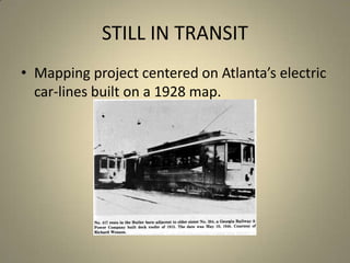
Atlanta's electric car routes, 1928
- 1. STILL IN TRANSIT Mapping project centered on Atlanta’s electric car-lines built on a 1928 map.
- 2. MAPPING PROJECT Tracing the routes of electric cars on 50 maps of Atlanta in 1928. Each route comprises line segments without a break: over 700 such lines. Unearthing historical sources for data, anecdotes, photographs. Hyper-linking routes and attaching information to the maps.
- 4. Attaching narrative to place
- 8. Scanned maps of Atlanta 1928
- 10. Before a curve, intersection or deviation, the line is ended with a double-click.
- 14. No. 19?
- 15. Historical route map of June 1924
- 18. Meta-data
- 20. The data currently includes ownership details, route changes, historical information, photographs as well as anecdotes.
- 22. Challenge: Presenting dense data
- 23. Using mapping in pedagogy Feminist action: Immediacy of marking sites of harassment/violence; sense of ‘action’. Acquaintance with new place: Understanding, exploring historical records/changes. Combining data and visual to present layered account of space, place and information. Mapping genealogies, relationships, structures? This is an experiment!
Editor's Notes
- http://www.ingentaconnect.com//content/brill/rip/1999/00000029/00000001/art00003: Thomas R. Flynn (1999). The Philosopher-Historian as Cartographer: Mapping History with Michel Foucault.Research in Phenomenology 29 (1):31-50.