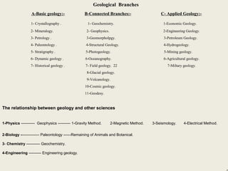
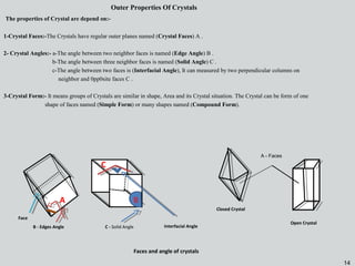
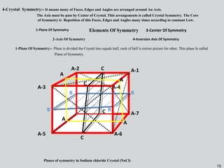
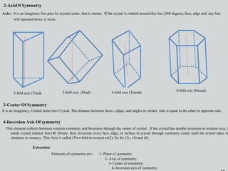
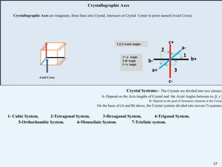
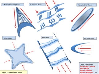
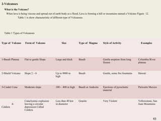
The document provides information about geology and the structure of the Earth. It discusses the following key points:
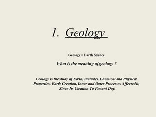
1. Geology is the study of the Earth, including its chemical and physical properties, formation processes, and changes from creation to present day.
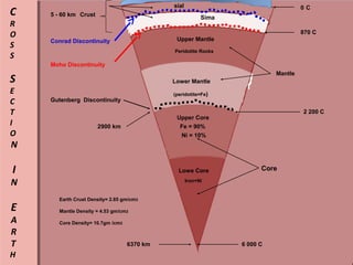
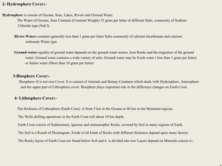
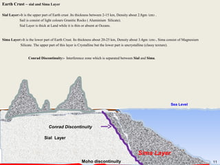
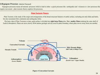
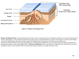
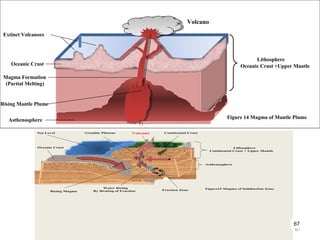
2. The Earth is composed of several layers including the crust, mantle, outer core, and inner core. The crust and upper mantle make up the lithosphere which is divided into tectonic plates.
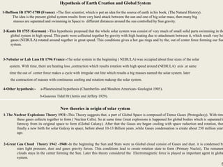
3. The formation of the Earth and solar system is explained by several hypotheses including the nebular hypothesis which postulates that the Earth formed from a contracting cloud of gas and dust around the sun.
The document discusses facts about planet Earth. It describes Earth's three main layers - the crust, mantle, and core. The crust is made up of tectonic plates that are constantly shifting due to convection currents in the mantle. This movement of the plates over millions of years can cause continents to collide, drift apart, or move past each other in the process of continental drift, which is still occurring today.
Earth is composed of four main layers - crust, mantle, outer core, and inner core. The crust is the outermost layer and is made up of either continental or oceanic crust. Below the crust is the mantle, which is divided into lithosphere, asthenosphere, upper mantle, and lower mantle. The outer core is a liquid layer made of nickel and iron that generates Earth's magnetic field. The inner core is made of solid iron deep within Earth. Overall, Earth's composition is approximately 34.6% iron, 29.5% oxygen, and 15.2% silicon.
The Earth has several key features that support life, including an atmosphere containing oxygen, average temperatures of 15°C, and a water cycle. It rotates on its axis once every 24 hours, causing day and night, and revolves around the sun over the course of 365 days, causing the seasons. The moon orbits the Earth every 28 days and causes ocean tides. The Earth also has a molten iron core that generates a magnetic field protecting it from solar radiation.
The document provides information about the key characteristics of planet Earth. It discusses that Earth is the third planet from the sun, has an atmosphere with oxygen and liquid water, and is the only known planet capable of supporting life. It also describes Earth's size, composition, layers of the atmosphere, formation, rotation, seasons, and climate.
The Earth formed around 4.5 billion years ago. It is the third planet from the sun and the only known planet capable of sustaining life. The Earth has a molten iron core, a solid silicate mantle, and a crust consisting of tectonic plates that migrate across the surface over millions of years. The Earth's atmosphere, hydrosphere, and biosphere support around 8.7 million known species of life. Humans depend on the biosphere and minerals of the Earth, though pollution poses threats to both the environment and human health.
Earth formed about 4.5 billion years ago and is the only known planet that supports life. It has three main layers - a crust, mantle, and core. The crust ranges from 5-70 km deep and has both continental and oceanic parts. Below the crust is the thickest layer, the mantle, which extends to a depth of 2,890 km and is composed of silicate rocks. The innermost layer is the core, with a solid inner core of iron and nickel around 1,220 km wide and a liquid outer core that creates Earth's magnetic field.
Earth is the third planet from the sun and is 12,700km long. It takes one day for Earth to rotate on its axis and one year to revolve around the sun. Earth is nicknamed the blue planet because it is mostly made of water, has gravity, oxygen, plants, animals, and humans, and is the only known living planet.
This document provides information about the Earth and the formation of the solar system. It discusses how the Earth is uniquely suited to support life due to factors like its distance from the sun, size, atmosphere, and rotation. It describes how elements are formed through nuclear fusion and radioactive decay. Hydrogen is the most abundant element in the universe. The solar system formed from a rotating cloud of gas and dust that condensed due to gravity to form the sun and planets. The Earth differentiated into layers with different compositions - an iron-nickel core, silicate mantle, and crust made of less dense elements.
The document summarizes the composition and structure of Earth. It is divided into four interconnected spheres: the atmosphere, hydrosphere, lithosphere, and biosphere. The atmosphere is composed primarily of nitrogen and oxygen and contains weather and protects the planet. The hydrosphere includes all water on Earth, both liquid and frozen. The lithosphere is the solid crust and interior of the planet. Finally, the biosphere contains all living organisms on Earth.
This document provides information about the formation and composition of planet Earth and the solar system. It discusses:
1) How Earth is uniquely suited to support life due to factors like its distance from the sun, size, atmosphere, and rotation.
2) The processes that led to the formation of elements, including nuclear fusion and radioactive decay. Hydrogen is the most abundant element in the universe.
3) How the Earth differentiated into layers with different compositions - a crust, mantle, and core. The crust also differentiates into continental and oceanic crust with different thicknesses, densities, and compositions.
This document summarizes the differentiation of the Earth. It discusses how the Earth initially formed as a molten mass and over time separated into layers with the heavier materials sinking to the center to form the core. The two main theories for this differentiation are homogeneous and heterogeneous accretion. Evidence from the Moon supports the Earth differentiating into layers early in its formation history around 4.5 billion years ago. The Earth is now composed of concentric layers that decrease in density from the iron-nickel core, to the silicate mantle, and finally the crust at the surface.
The Earth is composed of several concentric layers. The inner core is solid and suspended in the molten outer core, which generates the Earth's magnetic field through convection. Below this is the lower mantle, composed primarily of silicon, magnesium and oxygen. The upper mantle extends from 10-400km deep and includes olivine and pyroxene minerals, and may partially be molten. Above this is the transition region that includes basaltic magmas and minerals like garnet. The outermost layers are the oceanic and continental crusts, the former made of basalt from sea floor spreading and the latter composed mainly of low-density minerals like quartz and feldspar.
The document summarizes the geological history of Earth from its formation 4.54 billion years ago to the present. It describes how Earth accreted from a solar nebula, the development of its atmosphere and oceans, the early heavy bombardment period, the formation of the moon via a giant impact, and the beginnings of plate tectonics. It then outlines the major eons and eras of Earth history including the formation and breakup of supercontinents, snowball Earth periods, and mass extinction events that shaped the biosphere.
The document discusses the phases of the moon. It explains that the moon does not produce its own light, but rather reflects light from the sun. As the moon orbits Earth, different portions are illuminated by the sun, appearing to change shape from our perspective on Earth. This cycle, where the illuminated portion appears to grow and then shrink over the course of around 29.5 days, is what causes the phases of the moon. The document then defines and provides images for each of the 8 main phases: new moon, waxing crescent, first quarter, waxing gibbous, full moon, waning gibbous, last quarter, and waning crescent.
The document provides information about the Earth. It discusses that the Earth is a planet in the solar system and is a habitable planet due to its temperatures, atmosphere, and water. It describes the Earth's shape as a geoids that is flattened at the poles. It also discusses the Earth's rotation which causes day and night and its revolution around the sun which causes the seasons. The document then covers the Earth's elements including the atmosphere, geosphere, and hydrosphere. It concludes by discussing how maps represent the Earth using cartographic projections and resources.
The lithosphere is Earth's outer layer consisting of soil and rock. It ranges from 64-96 km thick and is broken into tectonic plates. The lithosphere includes two types - oceanic lithosphere associated with oceanic crust in ocean basins, and continental lithosphere associated with continental crust. Beneath the lithosphere lies the mantle, which is divided into the asthenosphere and mesosphere, and below that is the core consisting of an inner solid section and outer molten section.
Changes in the earth and its atmosphereSteve Bishop
The document summarizes changes to the Earth's core, mantle, crust, and atmosphere over time. It describes the theory of tectonic plates and how their movement causes earthquakes and volcanic eruptions. It explains how early theories of continental drift were rejected but later accepted when ocean floor investigations found evidence supporting plate tectonics. It also outlines how the atmosphere was initially composed of gases like carbon dioxide and methane, and how oxygen levels increased due to photosynthesis by plants and algae.
The document discusses the layers of the lithosphere. The lithosphere includes the crust and upper mantle, which make up the rigid outer layer of the Earth. The crust is the outermost layer and varies in thickness from 32-40 km. It is divided into two layers - the upper sial and lower sima. Below the crust is the mantle, which is around 2,900 km thick and composed of hot, solid rock that flows slowly over time. The three main layers of the lithosphere are the crust, upper mantle, and lower mantle.
The document provides information about various celestial bodies in our solar system including:
- The sun is a star that is approximately 150 million kilometers from Earth and it takes light about 8 minutes to reach us.
- Mercury is the closest planet to the sun and has extreme temperature variations.
- Venus is similar in size to Earth but has a toxic atmosphere and rotates backwards.
- Earth is the only known planet capable of supporting life.
Mars is the fourth planet from the Sun and is known as the "Red Planet" due to the iron oxide on its surface. It has a thin atmosphere composed primarily of carbon dioxide with traces of other gases. While early theories hypothesized life on Mars, the first flyby mission revealed desert-like terrain and no signs of life. Liquid water cannot exist on the surface today due to low atmospheric pressure, but evidence suggests water once flowed on Mars. With specific conditions like the presence of water and oxygen traces, human life may be possible on Mars in the future.
Earth is the third planet from the Sun and the only known planet to harbor life. It is called the Earth, meaning ground, in English and German, as well as the blue planet due to its abundant water and atmospheric hue. Wind carries over 100 million tons of sand grains around the world each year and Antarctica is the coldest place on Earth as the entire continent is made of ice.
The document provides information about planet Earth. It discusses that Earth is the third planet from the sun, the largest of the inner planets, and is known by names like the Blue Planet. It formed 4.6 billion years ago from a solar nebula and molten material that collided to form the planet. Early Earth had extreme conditions that changed over time as the atmosphere stabilized and continents formed, allowing life to emerge in the oceans. The document details Earth's structure, composition, atmosphere, seasons, and key facts about its orbit, rotation, and relationship to the moon.
Geochemistry involves studying the chemical composition of Earth and other planets, as well as the chemical processes that govern rocks, water, and soils. It examines how chemical elements are distributed and move through different parts of Earth over time. Key techniques for geochemical analysis include electron probe microanalysis and X-ray fluorescence spectrometry. Proper interpretation of geochemical data requires considering analytical uncertainty and discussing limitations with laboratory experts.
The document discusses Earth's structure and plate tectonics. It describes how seismic waves can reveal Earth's internal layers and how the inner core generates the planet's magnetic field. It also summarizes the development of the theory of plate tectonics through studies of ocean floor mapping, magnetic reversals, earthquake locations, and polar wandering. Plate boundaries are classified as divergent, convergent, or transform, each producing different surface features.
This document provides an overview of earth materials including atoms, elements, minerals, and rocks. It discusses the basic building blocks of atoms and elements. It describes the main types of minerals and the 12 most common rock-forming minerals. It also summarizes the three main types of rocks - igneous, sedimentary, and metamorphic - and explains their formation processes. Key geological processes like weathering and the rock cycle are also summarized.
This document provides an introduction to sedimentology and stratigraphy. It discusses key concepts such as sedimentology focusing on accumulation under uniform conditions while stratigraphy records changes over time. Sedimentary rocks form through weathering, erosion, transport, deposition, lithification and diagenesis. Scientists study facies, depositional systems, and system tracts to interpret ancient environments. Stratigraphy reflects changes in the balance between space creation and filling in sedimentary basins. Correlating rock units across regions is important for stratigraphic research.
This document discusses stratigraphy and related geological concepts. It begins by outlining the contents of stratigraphy, including principles of sequence stratigraphy, sedimentary basins, models in sedimentary geology, and applied sedimentary geology. It then discusses key stratigraphic concepts like lithostratigraphy, chronostratigraphy, and biostratigraphy. Finally, it covers principles of correlation, criteria for stratigraphic classification, and elements of correlation like time units, rock units, and correlation methods involving lithological, biostratigraphic, and radioactive dating controls.
Stratigraphy is the study of temporal relationships in sedimentary rock layers and reflects changes in the balance between the rates of space production and filling. Stratigraphy records past geological events and adds a temporal dimension to sedimentology. It preserves details of major geologic events like mountain building, sea level changes, and climate fluctuations through principles such as superposition, original horizontality, lateral continuity, and crosscutting relationships.
1) Stratigraphy is the chronological study of sedimentary rocks to understand the history of the Earth. It reveals details of past climate, geography, evolution, and more.
2) The principles of stratigraphy include lithology, order of superposition, and fossil content. Lithology is the study of rock compositions and minerals. Order of superposition means younger rocks are deposited above older rocks. Fossils provide information about past life.
3) The geological time scale divides Earth's history into eras, periods, and epochs to correlate rock formations worldwide. It allows reconstruction of the planet's environmental changes over time.
Sequence stratigraphy involves subdividing stratigraphic records based on bounding discontinuities. A depositional sequence is defined as a succession of genetically related strata bounded by unconformities and correlative conformities. During a sequence, systems tracts are deposited in response to changes in relative sea level, including highstand, falling stage, lowstand, and transgressive tracts bounded by surfaces like sequence boundaries, transgressive surfaces, and flooding surfaces.
This document discusses different sedimentary environments including terrestrial, marginal marine, and marine settings. Terrestrial environments include fluvial systems like braided rivers and meandering streams, alluvial fans, glacial deposits, lacustrine environments, and aeolian deposits in deserts. Marginal marine environments are located along the continental boundary and include beaches, barrier islands, lagoons, estuaries, and tidal flats. Marine environments discussed are coral reefs, continental shelf, continental slope, continental rise, and abyssal plain. Different sedimentary structures form in each environment providing clues to depositional conditions.
Geology is the study of the Earth, including its composition, structure, physical properties, history, and the processes that act on it. The Earth formed around 4.5 billion years ago from the solar nebula. It differentiated into a solid crust and mantle, and a liquid outer core and solid inner core due to gravity and radioactive heating. The Earth has since undergone significant internal and external changes. The atmosphere formed from gases released from volcanoes, and the oceans formed as water accumulated on the cooling surface. Life emerged on Earth around 3.5 billion years ago. The lithosphere is divided into tectonic plates that move over the mantle due to convection currents in the upper mantle. The biosphere interacts with and alters
The document provides an overview of various earth sciences including geology, oceanography, meteorology, astronomy and how they relate to understanding the formation and evolution of Earth over time. It discusses theories of catastrophic formation versus uniformitarianism and how evidence now supports aspects of both. It also outlines Earth's major spheres of the hydrosphere, atmosphere, geosphere and biosphere and how they interact as part of the dynamic, interconnected Earth system.
Origin and interiors of the earth LECTURE OF CIVIL ENGINEERING DRAWINGSafiullah Khan
This document provides an overview of engineering geology and the interior structure of Earth. It discusses:
- Engineering geology as the application of geology to civil engineering projects.
- The interior structure of Earth, including the crust, mantle (with upper, lower, and outer layers), liquid outer core, and solid inner core.
- Theories for the origin of Earth, including the nebular hypothesis of Kant and Laplace where Earth formed from a contracting gas cloud/nebula around the sun.
This document provides an overview of the internal structure of the Earth. It describes the three main layers - crust, mantle, and core. The crust is the outermost layer and is divided into continental and oceanic crust. Beneath the crust is the mantle, which makes up most of the Earth's volume. The core is at the center and has a solid inner core and liquid outer core. Seismic waves and magnetic reversals provide evidence about the composition and movement of materials in the Earth's interior.
Earth's internal heat comes from three main sources:
1) The accretion of dust and gas particles during the Earth's formation released gravitational potential energy and caused internal heating.
2) Radioactive decay of elements in the Earth's core and mantle, such as uranium and potassium, continues to generate heat.
3) Frictional heating from convection currents in the mantle also contributes to the Earth's internal heat. Seismic waves have allowed scientists to indirectly learn about the Earth's layered structure despite only drilling about 7 miles deep.
Geology is the study of the Earth, including its composition, structure, physical properties, and history. Physical geology examines the materials and processes that shape the Earth, while historical geology examines the origin and evolution of the planet over time. A key theory in geology is plate tectonics, which proposes that the Earth's crust is composed of plates that move relative to one another.
1. The document outlines an Earth and Life Science curriculum for Grade 11 covering topics in Earth Science, Geology, Meteorology, and Astronomy.
2. It includes pre-tests on the solar system, planets, and the Big Bang theory. Activities include a jumbled words exercise and an origins of the universe quiz.
3. The curriculum will examine theories on the origins of the solar system and universe such as the nebular hypothesis and provide assignments on the fate of the universe and possibility of finding Earth-like exoplanets.
1. The formation and evolution of the Solar System began about 4.57 billion years ago with the gravitational collapse of a small part of a giant molecular cloud. Most of the collapsing mass collected in the center to form the Sun, while the rest flattened into a protoplanetary disk from which the planets, moons, asteroids and other small bodies formed.
2. According to the nebular hypothesis, Earth formed about 4.54 billion years ago from accretion of planetary material in the solar nebula. Within the first 100-200 million years, early Earth had formed extensive oceans and seas.
3. Key events in the development of early Earth included the formation of its layered internal structure through the sinking of
The document summarizes the internal structure and dynamics of the Earth. It describes how the Earth can be divided into layers based on composition and physical properties. It discusses seismic wave evidence that reveals boundaries between the crust, mantle, and core. Plate tectonics theory is introduced to explain how convection currents in the mantle cause the movement of lithospheric plates over time, resulting in earthquakes and volcanic activity at plate boundaries. The risks of earthquakes and volcanic eruptions associated with plate tectonics are also summarized.
Chapter 2 Geology of Ethiopia and the Horn. The geology of Ethiopia includes rocks of the Neoproterozoic East African Orogeny, Jurassic marine sediments and Quaternary rift-related volcanism. Events that greatly shaped Ethiopian geology is the assembly and break-up of Gondwanaland and the present-day rifting of Africa.
This power point is important for all Ethiopian first year freshman universities students for the common course of Geography of Ethiopia and the Horn (GeES 1011), It is prepared on the bases of the module with additional explanations, important maps & explanatory images are included.
This power point mainly focuses on the geological history of the Earth in general and Ethiopia in particular. It is the best source of for all first year university freshman student of Ethiopia. if you are studying this course for A+ this material will definitely help. this material proven to be helpful by students of number of universities for the past four years.
This document provides an introduction to seismology. It discusses how seismology studies earthquakes and the propagation of energy through the Earth's crust. It then describes the formation of the Earth and its layers, including the crust, mantle, outer core, and inner core. It explains what causes earthquakes, such as the movement of tectonic plates and the rupture of rocks along faults. Finally, it discusses evidence that supported Alfred Wegener's theory of continental drift and how plate tectonics helps explain the distribution of earthquakes and volcanic activity at plate boundaries.
foundations of astronomy - the very basicsMaryPavlenko
The document provides information about the Earth and Moon. It summarizes that the Earth is differentiated with an iron core, silicate mantle and crust. The mantle flows like a liquid due to heat convection. Plate tectonics causes geological activity. Radiometric dating indicates the Earth is approximately 4.6 billion years old. The Moon has no atmosphere or magnetic field and its surface is dominated by impact craters. Evidence suggests there may be water ice at the lunar poles.
The origin of the elements began with the Big Bang, which created hydrogen. Hydrogen gas clouds condensed to form main sequence stars that fused hydrogen to form helium and heavier elements through nuclear fusion. These main sequence stars then formed oxygen and carbon. On Earth, the heavy elements were created when a supernova exploded, ejecting matter that condensed into our solar system. Life on Earth is protected by the atmosphere, which was made suitable for life as vegetation absorbed carbon dioxide and produced oxygen. Large impacts from asteroids and comets have caused mass extinctions on Earth by blocking sunlight with dust.
The document discusses the Earth's internal structure and processes. It describes two models that explain the Earth's internal layers: the geochemical model which divides the Earth into crust, mantle, and core, and the dynamic model which divides it into lithosphere, asthenosphere, mesosphere, and endosphere. The primary cause of Earth's internal activity is convection currents transferring heat from the core outward. This movement of heat drives the movement of tectonic plates at convergent, divergent, and transform boundaries, resulting in geologic processes such as volcanoes and earthquakes.
Origin of Earth, Big Bang theory, Nebular hypothesis, Internal heating of earth, formation of Earth's crust and inner structure, evolution of continents, oceans and atmosphere, continental drift theory, origin of life, Geological Time Scale.
Here are the key points about heat and temperature scales:
1) Heat is the total amount of thermal energy in an object or system. Temperature is a measure of how hot or cold something is compared to a reference point.
2) Fahrenheit uses 32°F as the freezing point of water and 212°F as the boiling point. Celsius uses 0°C as the freezing point and 100°C as the boiling point. Kelvin uses 0K as absolute zero. Water freezes at 273.15K and boils at 373.15K.
3) Dew point is the temperature at which water vapor in air will condense into liquid water. Condensation occurs when air reaches saturation point and can hold no
The document discusses several hypotheses for the origin of the universe and the solar system. It states that the widely accepted Big Bang Theory proposes that the universe began approximately 13.8 billion years ago from the violent expansion of space-time and extremely dense and hot matter. It also describes the Nebular Hypothesis for the formation of the solar system, which suggests that the sun and planets formed from a giant rotating cloud of gas and dust approximately 4.6 billion years ago. Additionally, it briefly outlines other hypotheses such as the Creationist Theory, Oscillating Universe Theory, and Steady-State Theory.
Electric vehicle and photovoltaic advanced roles in enhancing the financial p...IJECEIAES
Climate change's impact on the planet forced the United Nations and governments to promote green energies and electric transportation. The deployments of photovoltaic (PV) and electric vehicle (EV) systems gained stronger momentum due to their numerous advantages over fossil fuel types. The advantages go beyond sustainability to reach financial support and stability. The work in this paper introduces the hybrid system between PV and EV to support industrial and commercial plants. This paper covers the theoretical framework of the proposed hybrid system including the required equation to complete the cost analysis when PV and EV are present. In addition, the proposed design diagram which sets the priorities and requirements of the system is presented. The proposed approach allows setup to advance their power stability, especially during power outages. The presented information supports researchers and plant owners to complete the necessary analysis while promoting the deployment of clean energy. The result of a case study that represents a dairy milk farmer supports the theoretical works and highlights its advanced benefits to existing plants. The short return on investment of the proposed approach supports the paper's novelty approach for the sustainable electrical system. In addition, the proposed system allows for an isolated power setup without the need for a transmission line which enhances the safety of the electrical network
Advanced control scheme of doubly fed induction generator for wind turbine us...IJECEIAES
This paper describes a speed control device for generating electrical energy on an electricity network based on the doubly fed induction generator (DFIG) used for wind power conversion systems. At first, a double-fed induction generator model was constructed. A control law is formulated to govern the flow of energy between the stator of a DFIG and the energy network using three types of controllers: proportional integral (PI), sliding mode controller (SMC) and second order sliding mode controller (SOSMC). Their different results in terms of power reference tracking, reaction to unexpected speed fluctuations, sensitivity to perturbations, and resilience against machine parameter alterations are compared. MATLAB/Simulink was used to conduct the simulations for the preceding study. Multiple simulations have shown very satisfying results, and the investigations demonstrate the efficacy and power-enhancing capabilities of the suggested control system.
Optimizing Gradle Builds - Gradle DPE Tour Berlin 2024Sinan KOZAK
Sinan from the Delivery Hero mobile infrastructure engineering team shares a deep dive into performance acceleration with Gradle build cache optimizations. Sinan shares their journey into solving complex build-cache problems that affect Gradle builds. By understanding the challenges and solutions found in our journey, we aim to demonstrate the possibilities for faster builds. The case study reveals how overlapping outputs and cache misconfigurations led to significant increases in build times, especially as the project scaled up with numerous modules using Paparazzi tests. The journey from diagnosing to defeating cache issues offers invaluable lessons on maintaining cache integrity without sacrificing functionality.
Digital Twins Computer Networking Paper Presentation.pptxaryanpankaj78
A Digital Twin in computer networking is a virtual representation of a physical network, used to simulate, analyze, and optimize network performance and reliability. It leverages real-time data to enhance network management, predict issues, and improve decision-making processes.
Generative AI Use cases applications solutions and implementation.pdfmahaffeycheryld
Generative AI solutions encompass a range of capabilities from content creation to complex problem-solving across industries. Implementing generative AI involves identifying specific business needs, developing tailored AI models using techniques like GANs and VAEs, and integrating these models into existing workflows. Data quality and continuous model refinement are crucial for effective implementation. Businesses must also consider ethical implications and ensure transparency in AI decision-making. Generative AI's implementation aims to enhance efficiency, creativity, and innovation by leveraging autonomous generation and sophisticated learning algorithms to meet diverse business challenges.
https://www.leewayhertz.com/generative-ai-use-cases-and-applications/
Discover the latest insights on Data Driven Maintenance with our comprehensive webinar presentation. Learn about traditional maintenance challenges, the right approach to utilizing data, and the benefits of adopting a Data Driven Maintenance strategy. Explore real-world examples, industry best practices, and innovative solutions like FMECA and the D3M model. This presentation, led by expert Jules Oudmans, is essential for asset owners looking to optimize their maintenance processes and leverage digital technologies for improved efficiency and performance. Download now to stay ahead in the evolving maintenance landscape.
DEEP LEARNING FOR SMART GRID INTRUSION DETECTION: A HYBRID CNN-LSTM-BASED MODELijaia
As digital technology becomes more deeply embedded in power systems, protecting the communication
networks of Smart Grids (SG) has emerged as a critical concern. Distributed Network Protocol 3 (DNP3)
represents a multi-tiered application layer protocol extensively utilized in Supervisory Control and Data
Acquisition (SCADA)-based smart grids to facilitate real-time data gathering and control functionalities.
Robust Intrusion Detection Systems (IDS) are necessary for early threat detection and mitigation because
of the interconnection of these networks, which makes them vulnerable to a variety of cyberattacks. To
solve this issue, this paper develops a hybrid Deep Learning (DL) model specifically designed for intrusion
detection in smart grids. The proposed approach is a combination of the Convolutional Neural Network
(CNN) and the Long-Short-Term Memory algorithms (LSTM). We employed a recent intrusion detection
dataset (DNP3), which focuses on unauthorized commands and Denial of Service (DoS) cyberattacks, to
train and test our model. The results of our experiments show that our CNN-LSTM method is much better
at finding smart grid intrusions than other deep learning algorithms used for classification. In addition,
our proposed approach improves accuracy, precision, recall, and F1 score, achieving a high detection
accuracy rate of 99.50%.
VARIABLE FREQUENCY DRIVE. VFDs are widely used in industrial applications for...PIMR BHOPAL
Variable frequency drive .A Variable Frequency Drive (VFD) is an electronic device used to control the speed and torque of an electric motor by varying the frequency and voltage of its power supply. VFDs are widely used in industrial applications for motor control, providing significant energy savings and precise motor operation.
1. 1. Geology
Geology = Earth Science
What is the meaning of geology ?
Geology is the study of Earth, includes, Chemical and Physical
Properties, Earth Creation, Inner and Outer Processes Affected it,
Since Its Creation To Present Day.
3. 3
History of Geology
1-Humorous 600 B C :-He put an idea about the shape of Earth and he descript the earth as a disc surround by water.
2-Aresto 384-322 B C :-He is provided that the Earth is a ball by scientific method . by observation he is noticed that, the matter
collection is to the same center .
3-Herodotus 424-484 B C:-The first scientist who noticed the remaining of Botany and Animals on the mountains of earth crust ,
which is prove that the present mountains were oceans surfaces in the deep past..
4-Khalelo 1546-1642 C :- He is Provided the motion of earth around its axis is from west to east .
5-William Smith 1769-1839 C :-He is the first scientist whose established stratigraphy and correlation by its contents of fossils and
he was drawing a geological map for e England in 1845 .
History of geology- Arab scientists
1-Ibin Siena died 1049 :-The first one who is established the geology and studied also the minerals .
2-Al Bairony died 1271 :-He is described an expensive crystals minerals in scientific methods .
3-Alrazi died 1369 :-He is divided the minerals into six groups in his book (secrets of the secrets) .
Other scientist such as Jahith Takishkhandy Sarkhasy et .
4. 4
The site of Earth within Galaxy (Milky Way)
SUN
Earth
Mercury
Venus
Mars
Jupiter
Saturn
Uranus
Neptune
Pluto
88 D
1.88Y
225D
11.86Y
29.46Y
82.02Y
164,8Y
247.7Y
D = Day
Y = Year
364.25 D
4
5. 5
Hypothesis of Earth Creation and Global System
1-Buffoon Ht 1707-1788 (France) :-The first scientist, which is put an idea for the source of earth in his book, (The Natural History).
The idea is the present global system results from very hard attack between the sun and one of big solar mass, then many big
masses are separated and swimming in Space to different distances around the sun controlled by Sun gravity.
2-Kants Ht 1755 (German) :-This hypothesis proposed that the whole solar system was consist of very much of small solid parts swimming in the
global system in high speed. This parts were collected together by gravity with high heating due to attachment between it, which result very ho
gases (NEBULA) rotated around together in great speed. This conditions gives a hot gas rings and by the, out of center force forming our Sun
system.
3-Nebular or Lab Lass Ht 1796 France:-The solar system in the beginning ( NEBULA) was occupied about four sizes of the solar
system. With time, there are heating loss ,contraction which results rotation with high speed around (NEBULA) axis .at same
time the out of center force makes a cycle with irregular out line which results a big masses named the solar system. later
the contraction of masses with continuous cooling and rotation makeup the solar system.
4-Other hypothesis:- a-Planetesimal hypothesis (Chamberlin- and Moulton American- Geologist 1905).
b-Gaseous Tidal Ht (Jemis and Jeffery 1929).
New theories in origin of solar system
1-The Nuclear Explosions Theory 1931:-This Theory suggests that, a part of Global Space is composed of Dense Gases (Protogalaxy). With time
these gases collects together to form ( Nuclear Cells). So at same time Great explosions is happened for global bodies which is separated i
faraway from its original space to form (Global Galaxy). After that the Gases are began cooling with space reduction and rotation, then
finally a new birth for solar Galaxy in space, before about 10-13 Billion years ,while Gases condensation is create about 250 million years
ago.
2-Great Gas Cloud Theory 1942 -1948:-In the beginning the Sun and Stars were as Global cloud consist of Gases and dust. it is condensed by
stars light pressure, dust and gases gravity forces. This conditions lead to create rotation state to form (Primary Nuclei), The remanen
clouds stays in the center forming the Sun. Later this theory considered the Electromagnetic force is played as important agent in globa
system.
5
6. 6
Earth Creation
Since 6 Billions years , the Earth was separated from Sun. So by rotation , continuous cooling ,the mass of gas
became Ball-shape covered by solid crust called (Earth crust ), while the inner of Earth still in Fusion state.
There are four stages at Earth Creation:-
1-Anhydric Period:-In this period the elements consists Earth differentiated into three zones ( Gases and liquids Earth crust, Mantle
and Core) depend on gravity, rotate around Earth,( mass of gases and liquids are the outer shall) as :-
a-Gases and Liquids zone.
b-Silicate-Sulfides zone--------Outer part (Earth crust).
c-Iron- Nickel zone-------------Inner part (Mantle and core).
-The cooling time of Earth crust is take about 900-1000 million years.
. 2-Oceanic Period( water Basins):-This period of Rains fall is due to the critical Temperature of water, which is form water
Vapor, then Rainfall within about 300- 400 million years.
3-Contraction Period:- A big water Basins such as oceans seas are the result of continuous cooling for earth crust, association
with mountains building within about 1000 -1700 million years.
4-Continintal Drift period:- There are many evidence says that, the Dry parts of earth (Crust) was connect in the ancient time.
Then by Earth Dynamic (Hypogene Processes) the crust moves along the fusion zone of Earth (upper
part of mantle-Asthenosphere) which is result sedimentary basins due to the big Oceanic sediment.
Conclusions:-
a-The Earth crust and air cover were buildup at first stage.
b-The water cover was buildup at second stage.
c-The ancients evidence of life is before 2500 million years.
7. 7
Nature of Earth
A-Dimensions of Earth :-
1-The polar Radius =6357 kilometre .
2-Equator Radius =6378 kilometre .
3-Polar Circumference = 6357 km x 2 x 22 ÷ 7 = 40 009 kilometre .
4-Equator Circumference = 6378 km x 2 x 22 ÷ 7 = 40 077 kilometre .
5-Area of earth surface = 510 000 000 square kilometre.
7-Dry area of earth surface = 29,22% = 149 000 000 square kilometre.
8-Water area of earth surface = 70.78% = 361 000 000 square kilometre.
9-highest point of dry area at earth surface = 8848 metre (Everest mountains crest).
10-Avverage of earth surface = 840 metre.
11-deeper point of ocean = 11033 metre (Mariana trench).
12-Average of ocean deep = 3808 metre.
Equator
Polar Dimension
7
8. 88
Crust
Upper Mantle
Lower Mantle
Upper Core
Lower
Core
sail
Sima
Conrad Discontinuity
Mantle
Moho Discontinuity
Core
(AsthenoSphere(
Gutenberg Discontinuity
(Mesosphere)
Peridotite Rocks
Pallasite Rocks ()
5 - 60 km
35 - 2900 km
2900 - 6370 km
Crust
Lower Mantle
Upper Core
Lowe Core
Sima
Mantle
Moho Discontinuity
Gutenberg Discontinuity
(peridotite=Fe)
5 - 60 km
Core
Upper Mantle
Peridotite Rocks
Conrad Discontinuity
Mantle Density = 4.53 gm/cm3
Core Density= 10.7gm /cm3
Earth Crust Density= 2.85 gm/cm3
0 C
870 C
2 200 C
6 000 C
Fe = 90%
Ni = 10%
C
R
O
S
S
S
E
C
T
I
O
N
I
N
E
A
R
T
H
C
R
O
S
S
S
E
C
T
I
O
N
I
N
E
A
R
T
H
sial
Iron+Ni
6370 km
2900 km
9. 9
Earth Covers
1-Atmosphere cover. 2-Hydrosphere cover.
3-Biosphere cover. 4-Lithosphere cover.
1-Atmosphere cover :-It is Air cover, surrounding Earth. Its thickness about 316 km . atmosphere is consist of many Gases like :-
a- N2 about 78%
b- O2 about 21%
c- Ar about 0.93
d- CO2 about 0.03%
e- H2 about 0.011
99.124%
About 35 PPM are inactive Gasses such as Neon, Helium and Ozone are present in Atmosphere .
1-Atmosphere Cover:-Atmosphere cover is divided into:-
A-Troposphere layer :-
1- Elevation of Troposphere layer is about 8 - 18 km .
2- Temperature is decreasing about 6 C every 1 km
rising
3-This layer is consist of homogenous gases, water
vapour, CO2 and dust.
B-stratosphere layer :-
1- The second layer with elevation about 50- 80 km .
2- The lower part of this Layer is (50 km) named
Ozone layer .
3- Stratosphere temperature is increase to 35 C with
no storm.
4- Stratospheric Pressure is 0.5 mm mercury (1/1520) of
Normal Pressure.
C-Ionosphere Layer:-
1- The elevation is about 80 – 316 km
2- the Ionization is due to the affects of the Cosmic and Ultra violent
Rays, so it is good Conductor for Electricity.
3- Many of (Meteors and Meteorites)are Burn with Traffic in this Layer.
4- This Layer is Good medium to cross Radio and Wireless Waves.
D-Exosphere layer :-
The highest layer in the Atmosphere ,so it is extend as far as entrance of outer
space .
Meteor:-
It is Solid, Small masses swimming in the space, but when it
falls on the Earth it called (Meteorites).
10. 10
2- Hydrosphere Cover:-
Hydrosphere is consist of Oceans, Seas, Lakes, Rivers and Ground Water.
The Water of Oceans, Seas Contains (Constant Weight) 35 gram per letter of different Salts, commonly of Sodium
Chloride type (NaCl).
Rivers Water:-contains generally less than 1 gram per letter Salts commonly of calcium bicarbonate and calcium
carbonate Water type.
Ground water:-quality of ground water depends on the ground water source, host Rocks and the migration of the ground
water. Ground water contains a wide variety of salts. Ground water may be Fresh water ( less than 1 gram per letter)
or Saline water (More than 10 gram per letter).
3-Biosphere Cover:-
Biosphere:-It is not true Cover. It is consist of Animals and Botany Creatures which deals with Hydrosphere, Atmosphere
and the upper part of Lithosphere cover. Biosphere plays important rule in the difference changes on Earth Crust.
4- Lithosphere Cover:-
The thickness of Lithosphere (Earth Crust) is from 5 km in the Oceans to 60 km in the Mountain regions.
The Wells drilling operations in the Earth Crust still about 10 km depth.
Earth Crust consist of Sedimentary, Igneous and metamorphic Rocks, covered by Soil in many regions of Earth.
The Soil is a Result of Disintegrate ,Erode of all kinds of Rocks with different thickness depend upon many factors.
The Rocky layers of Earth Crust are found below Soil and it is divided into tow Layers depend on Minerals consist it:-
11. 1111
Sima Layer
Sial Layer
Conrad Discontinuity
Moho discontinuity
Earth Crust – sial and Sima Layer
Sial Layer:-It is the upper part of Earth crust .Its thickness between 2-15 km, Density about 2.8gm /cm3 .
Sail is consist of light colours Granitic Rocks ( Aluminium Silicate).
Sial Layer is thick at Land while it is thin or absent at Oceans.
Sima Layer:-It is the lower part of Earth Crust. Its thickness about 20-25 km, Density about 3.4gm /cm3 . Sima consist of Magnesium
Silicate. The upper part of this layer is Crystalline but the lower part is uncrystalline (classy texture).
Conrad Discontinuity:- Interference zone which is separated between Sial and Sima.
Sea Level
11
12. 12
Earth Bottom
The Seismology:-The Seismology is good method to know the consists of Earth Bottom.
Moho (Yugoslavian Scientist) is the first one who notice Difference in Earth Layers by using the Primary and Secondary Waves.
The Waves behaviour are changed at depth about 35km, this means changes in properties of rocks Called Moho Discontinuity.
Moho Discontinuity:-it is an imaginary limited zone separated between earth crust and mantle at depth between 35-50 km
(depends on its position in different Continents).
Earth Mantle
The information about the mantle is get by geophysical methods, since the increasing of seismologic waves speed is leading to collection of
Ferric-magnesium which is mean dark colour rocks. Mantle thickness is about 2650 km.
Scientists are identified two Layers:-
Upper Layer (Peridotite):-The Density is about 3.4 gm/cm3 consist of Basic or Ultra basic Igneous Rocks with more Dark Colure.
Lower Layer (Pallasite):-It is consist of basic Minerals and Ferric Metals.
Earth Core (Centro Sphere)
The Thickness of Core is about 3600 km. The Core consist of Ferric about 90%, Nickel about 10%.
Scientists collects information about the core of Earth by indirect methods by way of seismological waves and Meteor, meteorites analysis which
are fall on Land from time to time.
The analysis of Meteor and Meteorites shows Ferric, Nickel and some Chromium and Cobalt Metals
Some Specialists divided Core of earth into:-
1- Outer Core (fusion).
2- Inner Core (Solid).
13. 13
1- Crystal:- Crystal is Sold body, homogenous in chemical compound, particular by Crystalline Planes.
The Minerals are creation Naturally in Earth Crust by way of (crystallization).
Amorphous:- it is no crystalline minerals, unstable chemical compound , unstable crystalline building, without chemical Formula.
Uncrystalline or Glassy Materials without geometric arrangement are not minerals.
Usually minerals are combined together forming Rocks.
Some minerals are Native like Gold, Diamond, Silver, Sulphur, Cupper, Graphite and Platinum.
Conclusion:- The earth crust is consist of:-
1- Crystals.
2- Minerals.
3- Rocks.
Earth Crust Consists
The Oxygen percentage about 50% .It is not free, but chemically Combined with Another Elements
to form element oxides. Since Si is at second order, the expectation SiO2 is the most existence
,Then AlO, FeO CaO and so on. Usually more of Metallic oxide is combined with silicon oxide to
form Silicate Materials like Potassium, Aluminium, Silicate(KAl2SiO8) and Magnesium,
Silicate(MgSiO3).These minerals are Naturally Crystalline with out human made and named
(Minerals). The Minerals are find in Nature as free or Minerals consist rocks. Minerals are creating
from Atoms in Geometric Arrangement which is differentiate every one of Minerals.
O=46.60
Si=27.7
A=l8.10
Fe=5.00
Ca=3.60
Na=2.80
K=2.60
Mg=2.10
Others=1.5
100%
Average of Elements consists
Earth Crust as Weight% are:-
13
14. 14
Outer Properties Of Crystals
The properties of Crystal are depend on:-
1-Crystal Faces:-The Crystals have regular outer planes named (Crystal Faces) A .
2- Crystal Angles:- a-The angle between two neighbor faces is named (Edge Angle) B .
b-The angle between three neighbor faces is named (Solid Angle) C .
c-The angle between two faces is (Interfacial Angle), It can measured by two perpendicular columns on
neighbor and 0pp0site faces C .
3-Crystal Form:- It means groups of Crystals are similar in shape, Area and its Crystal situation. The Crystal can be form of one
shape of faces named (Simple Form) or many shapes named (Compound Form).
Interfacial Angle
Face
B - Edges Angle C - Solid Angle
Closed Crystal
Open Crystal
Faces and angle of crystals
A B
C
A - Faces
14
15. 15
Elements Of Symmetry
1-Plane Of Symmetry:- Plane is divided the Crystal into equals half, each of half is mirror picture for other. This plane Is called
Plane of Symmetry.
1-Plane Of Symmetry:- Plane is divided the Crystal into equals half, each of half is mirror picture for other. This plane Is called
Plane of Symmetry.
1-Plane Of Symmetry
2-Axis Of Symmetry
3-Center Of Symmetry
4-Inversion Axis Of Symmetry
A-1
A-5
A-2
A-7
A-6
A-3
BB
BB
C
C
C
C
Planes of symmetry in Sodium chloride Crystal (NaCl)
A
A
A
A
4-Crystal Symmetry:- It means many of Faces, Edges and Angles are arranged around An Axis.
The Axis must be pass by Center of Crystal. This arrangements is called Crystal Symmetry. The Core
of Symmetry is Repetition of this Faces, Edges and Angles many times according to constant Low.
A-4
15
16. 16
2-AxisOf Symmetry
Axis:- It is an imaginary line pass by crystal center, that is means, If the crystal is rotated around this line (360 degree), face, edge and any line
will repeated twice or more.
2-AxisOf Symmetry
Axis:- It is an imaginary line pass by crystal center, that is means, If the crystal is rotated around this line (360 degree), face, edge and any line
will repeated twice or more.
3-fold axis (Triad) 2-fold axis (Diad) 4-fold axis (Tetrad)
6-fold axis (Hexad)
3-Center Of Symmetry
It is an imaginary, Central point into Crystal. The distance between faces , edges, and angles in certain side is equal to the other in opposite side.
4-Inversion Axis Of symmetry
This element collects between rotation symmetry and Inversion through the center of crystal . If the crystal has double inversion at rotation axis, i
needs crystal rotation for(180 )firstly, then inversion every face, edge, or surface in crystal through symmetry center until the crystal takes its
situation in vacancy. This Axis is called (Two-fold inversion) or(2). So for (3) , (4) and (6).
Extraction
Elements of symmetry are:- 1- Plane of symmetry.
2- Axis of symmetry.
3- Center of symmetry.
4- Inversion axis of symmetry.
17. 17
Crystal Systems:- The Crystals are divided into two classes:
A- Depend on the Axis lengths of Crystal and the Axial Angles between (α, β, γ )
B- Depend on the grad of Symmetry elements in the Crystal
On the basis of (A and B) above, the Crystal systems divided into (seven-7) systems:
1- Cubic System. 2-Tetragonal System. 3-Hexagonal System. 4-Trigonal System.
5-Orthorhombic System. 6-Monoclinic System. 7-Triclinic system.
c-
c+
b+b-
a-
a+
Axial Cross
2
1
3
1,2,3-Axial Angles
1= α Angle
2=β Angle
3 =γ Angle
Crystallographic Axes
Crystallographic Axes are imaginary, three lines into Crystal, intersects at Crystal Center in point named (Axial Cross).
17
18. 18
1-Cubic System A-Crystallographic axis 1-Three-Equals axis and Perpendicular on each others
B-Elements of Symmetry
1-Axis of Symmetry=13(3Tetrad-4 Triad-6 Diad)
2-Planes of Symmetry=9
3-Center of Symmetry=availab
1-Cubic System A-Crystallographic axis 1-Three-Equals axis and Perpendicular on each others
B-Elements of Symmetry
1-Axis of Symmetry=13(3Tetrad-4 Triad-6 Diad)
2-Planes of Symmetry=9
3-Center of Symmetry=availab
6 Diad
12-Face
a= b =c
Mineral Crystals are:-
1-Diamond-C
2-Halite- NaCl
3-Galena- PbS
4-Fluorite-CaF2
5-Garnet (Mg,Fe,Ca)3Si3O12(OH)
6-Sodalite-Na8(Al6Si6O24)Cl2
a
b
c
a - b - c
Crystallographic Axis
3 Tetrad
4 Triad
Construction unit
Sodalite Crystal
2-Tetragonal System
A-Crystallographic Axis:-Three axis (two are equals, perpendicular on each other, while the third is longer or shorter and perpendicular on the
two equals Axis.
B-Elements Symmetry:- 1-Axis of Symmetry= 5 Axis(1-Tetrad,4-Diad). 2-Planes of Symmetry= 5 3-Center of Symmetry=available.
Mineral Crystals are:- 1-Zircon-ZrSiO4
2-Rutile-Tio2
3-Cassiterite- SnO4
90
90
Zircon CrystalConstruction Unit
Crystallographic Axis
A = b ≠ c
a
b
c
c
o
19. 19
3-Hexagonal System
A-Crystallographic Axis:-Four Axis (Three are equal, The Angle between each two equal Axis is 120 . Fourth axis is Longer or
Shorter and perpendicular the plane of three equal Axis.
B-Elements of Symmetry:-
1-Axis of Symmetry= 7Axis(1-Hexad, 6-Diad).
2-Plane of Symmetry= 7
3-Center of Symmetry= available
Mineral Crystals are:-
1-Quartz- SiO2 2-Apatite-Ca5(PO4)3 (OH,F,Cl)
3-Nepheline-(Na3(Na,k)(Al4Si4)O16 4-Beryl
a
a
a
b
b
a=a=a≠b
Construction unit
7-Axis
4-Trigonal System
The Trigonal system is like Hexagonal
System except:-
a-Three equal axis and fourth axis is longer
or shorter.
a-One Axis of Symmetry ( 1- Triad ).
b-Non existence any horizontal planes
of Symmetry.
Mineral Crystals are:-
1-Calcite- CaCO3 2-Corundum-Al2O3
3-
Hematite-Fe2O3 4- Dolomite- (CaMg)CO3
4axis
19
20. 20
5- Orthorhombic System
A-Crystallographic Axis:- B-Elements of Symmetry:-
1- Three unequal Axis. 1- Axis of Symmetry = 3 (Diad).
2- The Axis are perpendicular 2- Planes of Symmetry = 3
each other. 3- Center of Symmetry=available.
5- Orthorhombic System
A-Crystallographic Axis:- B-Elements of Symmetry:-
1- Three unequal Axis. 1- Axis of Symmetry = 3 (Diad).
2- The Axis are perpendicular 2- Planes of Symmetry = 3
each other. 3- Center of Symmetry=available.
b
a
c
Crystallographic Axis
Construction Unit
a ≠ b ≠ c
Sulfur Crystal
S
Mineral Crystals are:-
1-Topaz-Al2(SiO4)(OH,F)2 2-Anhydrite-CaSO4 3-Sulfur – S
4-Andalusite-Al2SiO5 5-Olivine- (FeMg)SiO4 6-Barite-BaSO4
Anhydrite Crystal
Caso4
20
21. 21
A-Crystallographic Axis:- B-Elements of Symmetry:
1-Three unequal axis. 2-Two axis intersects (a and c) at oblique or inclined angle ( β ). 1-Axis of symmetry = 1 ( Diad
3- Third axis (b) is perpendicular plane of (a and c axes). conformable with (b) Axis
2-Plane of symmetry = 1
pass by (a and c) Axis.
3-Center of symmetry =available
C
b
a
β
90
Crystallographic Axis Construction Unit
Orthoclase Crystal
A ≠ b ≠ c
Mineral Crystals are:-
1-Orthoclase-KAlSi3O8
2-Gypsum-CaSO4 2H2O
3-Mica-(K,Al,Fe,Mg)Si4O10OH
4-Talc-Al4(Si8O20)(OH)4
5-Hornblende- (Ca,Mg,Fe,Al)
(OH)2 (Si,Al)4O11
β
7-Triclinic System
A-Crystallographic Axis B- Element of Symmetry:-
1-Three unequal axis. 1-Axis of symmetry =absent
2-Unperpendicular axis. 2-Plane of symmetry =absent
3-Center of symmetry = available
7-Triclinic System
A-Crystallographic Axis B- Element of Symmetry:-
1-Three unequal axis. 1-Axis of symmetry =absent
2-Unperpendicular axis. 2-Plane of symmetry =absent
3-Center of symmetry = available
a
c
b
A ≠ b≠ c
Oblique
Angle
Minerals Crystals are:-
1-Albite - NaAlSi3O8
6-Anorthite-CaAl2Si2O8
Plagioclase:-(2-Oligoclase) (3-Andesene)
(4-Labrodorite) (5-Bitonite)
6-Monoclinic System
21
22. 22
The Minerals
Minerals:-It is natural substance, solid, homogenous with systematic atomic building with particular chemical compound.
Minerals creation:-There are different sources and manner of minerals creation.
The minerals study is important to understand minerals accumulation, economic metals and ores deposits.
Minerals creation is divided into three sources:-
1- minerals creation of magma:-
1- Magma:-It is Fusion Rocks, Viscose, Dense, High Temperature for degree It is allow to Movement of Elements consist it.
Magma is available sub earth crust. But when Magma is moving up at Earth Surface through cracks, Fishers or
Volcanic activities, its fusion of Rocky is called - Lava
Most Minerals consist Earth crust are result of Magma or Lava Hardening.
The eight(8) Elements ( O, Si, Al, Fe, Mg, Ca, Na, k ) are compose about 99% of Magma. While Volatiles Materials
(Wat Vap, CO2, Cl, F, S etc) are compose 1% .
1-Magma Hardening is start with:- A- Silicates Minerals. B- Oxides Minerals. C-Sulfides Minerals.
A- Silicate Minerals:- 1- Plagioclase (Na, Ca)AlS3iO8 2-Olivine (Fe, Mg)SiO4 3- Pyroxene (Ca, Al, Fe, Mg)Si2O6
4-Amphibole(Ca ,Al, Fe, Mg)Si8O22 5-Mica K,Al,Fe,Mg)(Si4O10)(OH)
6-Orthoclase KAlSi3O8 7-Quartz SiO2
B- Oxide Minerals:- 1-Magnetite Fe3O4 2-Chromite FeCr2O4 3-Hematite Fe2O3 4-Quartz SiO2
C- Sulfide Minerals:- 1-Galena PbS 2-Pyrite FeS2 3-Chalcppyrite CuFeS2
22
23. 23
2-Minerals creation of solutions:- Solutions divided into:- A-Surface solutions. B-Underground Solutions.
A- Surface Solution:-Oceans, Seas, (Saline Water) Lakes, and Rivers.
1- Evaporation of Solutions (High T) = Crystalline Minerals. (Depend on Solubility Product of Ions which is consist Minerals).
CaCO3
MgCO3
K2CO3
Na2CO3
CaSO4
MgSO4
k2SO4
Na2SO4
CaCl2
MgCl2
KCl
NaCl
2- Exchange Reaction Between Solutions:- Sometimes Two solutions to be opposite , So reaction
together, resulting specialist Minerals:-
CaSO4+BaCO3 CaCO3(Calcite) + BaSO4 (Barite)
3-Creatures Affected On Solutions:-Some Animals and Plants in Seas Extracts certain dissolved
Ions to Build their Skeleton, Bone, Shell :-
a-Coral-Extracts CaCO3-Building Oyster, Sponges, Shells.
b- Foraminifera - Extracts Si –Shell Building.
c- Bacteria – Absorbed Fe and S oxides.
All these Creations after Dead may be consist a create quantities of detriatal sediments in Sea Floor.
Crystalline Minerals
(Evaporative Salts)
B-Under ground Solutions
The underground Solutions divided into:-
1-Hydrothermal Solutions:- This Solutions are remaining of Magma Crystallization, very hot, high pressure and saturated with dissolved Oxides,
Sulfides, Carbonate and so on. It is moving up faraway from its source through deep zones of Earth crust. During that It loss the temperature
and pressure gradually resulting hydrothermal Deposits which are divided into three type depend on Temperature and Pressure.
a-Hypothermal Deposits:- 500 - 300 C High pressure(deep zone) example
-Wolframite (Fe,Mn)WO4 -Molybdenite MoS2 -Cassiterite SnO2
b-Mesothermal Deposits :- 300 – 200 C Medium Pressure (Medium zone) example
-Calcite CaCO3 -Barite BaSO4 -Galena PbS -Sphalerite ZnS
C-Epithermal Deposits:- 50 – 0 C Low Pressure (shallow zone) example
-Quartz SiO2 -Calcite CaCO3 -Stibnite SbS2 -Opal Sio2 -Cinnabar HgS
Flourite CaF2 Marcasite fes2
SolubilityProduct
23
24. 24
2-Evaporation of Assistant Dissolved Gas
Underground Solutions contains dissolved CO2 Gas as a result of Rainfall.
This is result H2CO3 (weak Carbonic Acid), Which is dissolved Limestone and to form Calcium Bicarbonate Ca (HCO3)2.The later is
Chemically unstable. So It is escape CO2 Gas and come back to Calcium Carbonate.
CaCO3+H2O+CO2 Ca(HCO3)2 (Deposited Calcium Bicarbonate) (1)
Ca(HCO3)2 CO2+H2O+CaCO3 (Deposited Calcite) (2)
This phenomena is clear in Rainy, Cavities and Limestone Regions, Since Limestone is Deposit in Conical Shape as above
Equation, Named:- Stalactite and Stalagmite.
24
Hot Spring
Travertine
CaCO3
Cave
Mountain
Stalactite
Stalagmite
Hot Body
Water Table
Aquifer
25. 25
3-Minerals Creation of Gases
After Minerals Crystallization of Magma and Minerals Deposition of Hydrothermal Solutions, The remaining Solution ( 1% 0f Magma) becomes
enrichment with Volatiles and Gases ( Water Vapor, Cl, CO2, F, S, B ) The later try to escape from Magma under suitable conditions like
Pressure decreasing through Joints, Faults and rock pores. The Volatiles and Gases may be Reacted together or with surrounding different
Rocks to form a new Minerals
NEW MINERALS:-
Volatile Compound) SnF2 + 2H2O (Cassiterite) SnO2 + 4HF
Some times, Limestone affected by Hydrofluoric Acid (HF)
4HF + 2CaCO3 (Fluorite)2CaF2 + 2H2O + 2CO2
Another Minerals:- Tourmaline (Sl,B,Al,Fe,Mg,Na,O) Solution Rich Boron
Topaz Al2(SiO4)C(F, OH)2 Solution Rich Floured
When the Gases are near Earth Surface, they are try to escape through Volcanic Activities to form Sulfur S, Halite NaCl etc
25
27. 27
A-Physical Properties of Minerals
It Means the Natural Properties of Minerals which is divided into:-
1-0ptical Properties:- Include Properties depend on Light such as Color, Play of Colors, Luminescence, Streak, Transparency, Luster, Tarnish.
2-Cohesive Properties:- Depend on Cohesion and Strength of Minerals such as Hardness, Cleavage, Parting and Fracture.
3-Electrical and Magnetic Properties:- Like Pyroelectricity, Piezoelectricity, Paramagnetic, Diamagnetic.
4-Specefic Gravity.
5-Thermal Properties:- Like Fusion Degree.
6-Sense properties:- Depend on Senses like Taste, Perfume and Contact.
1- Optical Properties
A-Color:- It is the first physical properties which is noticed in the Field, so it can be divided into.
1-Constant Colors:- Gold and Sulfur (Metallic yellow), Malachite (Green) Cinnabar (Red).
2-Variable Colors:- Pure Quartz (Transparent), Impure Quartz (Rose, Smoky).
B-Play of Colors:- Some Minerals have different Colors through rotated it, because of light scattering, So Diamond is Good example. Another
Mineral show Silky Waves with rotation like Satin spar (one type of Gypsum).
C-Luminescence:- Some Minerals gives Light Radiation when it subject to Heat, X rays, Ultraviolent Rays, Fraction and Electrical Energy. The
light Radiation Color is different of the Mineral Color. When Radiation disappears with affected stopping the phenomena is
called (Fluorescence) Which is derive from Fluorite Minerals (CaF2). If Radiation Color stays during affected stopping,
Phenomena is called (Phosphorescence).
D-Streak:- It is Mineral Powder resulting from fraction on Streak Plane. Many Minerals have Streak Color different of Original Color, Such as
Pyrite(FeS2) is Yellow, while its Streak is Black. Chromite Mineral is Black Color, While the Streak is Brown color.
E-Transparency:- It is depend on mineral ability to pass light such as:-. 1-Galena, Gold, Pyrite are Opaque Minerals.
2-Pure Quartz, calcite, Gypsum layers are Semi Transparence. 3-Pure Muscovite is Transparence.
F-Luster:-This optical property depends on amount and kind of reflected light on Minerals. 1-Metalic luster--Gold , Silver , Galena , Pyrite.
2-Nonmetalic Luster:- 1-Glassy Luster – Likes normal Glass. 2-Adamantine – likes Diamond luster.
3-Pearly Luster, like Pearl luster – Talc and Mica minerals. 4-Silky Luster, One of Gypsum Kinds. 5-Earthy Luster, Likes Clay minerals Kaolin.
G-Tarnish:-Some minerals have different COLORS on mineral surface, as a result of outer layer analysis such as, Cupper, Bornite minerals.
Notice:- In tarnish case the original color is found only at new broken of mineral surface.
27
28. 28
2-Cohesive
The Cohesive Properties are Depend On Cohesion and Mineral Elasticity, Which is result of Ionic arrangement Strength. It is divided into:-
A -Hardness:- It is a degree of Mineral Resistance for Scratch, Scrape, fragment and Corrosion.
Mohs Scale of Hardness
1-Talc Al4(Si8O20)(OH)4 Human skin
2-Gypsum CaSO4 2(H2O)
3-Calcite CaCO3 Finger nail
4-Flourite CaF2
5-Apatite Ca5(Po3)4(OH,F,Cl) Kitchen knife
6-Orthoclase KAlSi3O8 Window Glass
7-Quartz SiO2
8-Topaz Al2(SiO4)C(F,OH)2 Steel File
9-Corundum Al2O3 (Yakut in Arabic)
10-Diamond C
B-Cleavage:-Many Minerals are easy cleave in systematic directions named (cleavage Planes) the Later is always parallel to
Mineral Crystal face at weak point.
C-Parting:-Likes Cleavage but it is in depend on Mineral Crystal Face or Weak point, So it is a result of outer Natural factors after Minerals
Consisting like Pressure and Tension.
D-Fracture:- It is a Mineral Surface Shape which is result of mineral broken at non cleavage Plane. So there are many types of Fracture
Planes like Conchoidal, Flat,Unflat, Toothed, Earthy.
28
29. 29
3-Electrical and Magnetic Properties
A- Electrical properties:-1- Some minerals are good electric conductor like Graphite (C), some of oxides minerals (Hematite - Fe2O3) and
Sulfide Minerals (Galena – PbS).
2-Most Minerals are bad or Non Electric Conductor.
3-Some Minerals becomes charged with Electricity in case of Heating. This phenomena called (Pyroelectricity). Tourmaline Mineral is good
example which is use in temperature Measurement result from Bombs Explosion.
4-Quartz Mineral is charged with Electricity under direct Pressure (Piezoelectricity). It is useful phenomena for Industry of Radio and
wireless Instruments.
B-Magnetic Properties
Some Minerals have ability to pull a magnet while another's are Repulsive a Magnet.
A- Paramagnetic Minerals:- It is the Minerals which are Pull or Attractive Magnet like Magnetite (Fe3O4) – Hematite (Fe2O3)
B-Diamagnetic Minerals:- It is the Minerals which are Repulsive a Magnet like Quartz (SiO2) – Calcite(CaCO3) – Zircon(ZrSiO4) .
These Properties are used in Geophysical Explorations for some Metallic Ore Deposits like Fe, Ni Ores.
4-Specific Gravity:-
Mineral Weight in Air
Specific Gravity = X Solution Density
Mineral Weight in Air – Mineral Weight in Solution
Specific Gravity is constant for the minerals at constant temperature and chemical condition.
.
B-Magnetic Properties
Some Minerals have ability to pull a magnet while another's are Repulsive a Magnet.
A- Paramagnetic Minerals:- It is the Minerals which are Pull or Attractive Magnet like Magnetite (Fe3O4) – Hematite (Fe2O3)
B-Diamagnetic Minerals:- It is the Minerals which are Repulsive a Magnet like Quartz (SiO2) – Calcite(CaCO3) – Zircon(ZrSiO4) .
These Properties are used in Geophysical Explorations for some Metallic Ore Deposits like Fe, Ni Ores.
4-Specific Gravity:-
Mineral Weight in Air
Specific Gravity = X Solution Density
Mineral Weight in Air – Mineral Weight in Solution
Specific Gravity is constant for the minerals at constant temperature and chemical condition.
. 29
30. 30
5- Thermal Properties:- Fusion is The Important Property to identified Minerals Which have different Fusion Temperature as:-
(Stepenite - 525C) (Halite – 800C) (Silver – 960C) (Gold – 1062C) (Quartz – 1650 1700C) (Platinum – 1755C).
Some Minerals change directly to Gas with out pass in Fusion state like Arsenic
6-Sense Properties:- This Property is depend on Many Senses like Feel or Tough, Taste and Perfume as:-
1-Talc Mineral Al4(Si8O20)(OH)4 Fatty or Soapy Tough.
2-Halite Mineral NaCl Salty Taste.
3-Pyrite Mineral FeS2 With Heating – Sulfur perfume.
B-Chemical properties of Minerals
The Minerals are Consist of (Major Elements – High Percentage) and (Trace Elements – Very Low Percentage). The Detection of Minerals
Composition are by Methods of:-
A-Qualitative Method:- It is Quick method to detects major elements by Flame Color which is reflect Element Type.
B- Quantitative Method:-It Means Detection the Percentage of Elements which are Consist Minerals by many Physical and Chemical
methods:-
1-Chemical Methods:-
a-Volumetric Method.
b-Gravimetric Method.
2-Phsical Methods:-
a-Spectrographic Method.
b-X – Ray Fluorescence.
c-Electron Microprobe.
30
31. 31
B-Chemical properties of Minerals
The Minerals are Consist of (Major Elements – High Percentage) and (Trace Elements – Very Low Percentage). The Detection of Minerals
Composition are by Methods of:-
A-Qualitative Method:- It is Quick method to detects major elements by Flame Color which is reflect Element Type.
B- Quantitative Method:-It Means detection the percentage of elements which are consist minerals by many physical and chemical methods:-
1-Chemical Methods:- a -Volumetric Method. b-Gravimetric Method.
2-Phsical Methods:- a-Spectrographic Method. b-X – Ray Fluorescence. c-Electron Microprobe.
Crystal Chemistry of Minerals
It is depend on relationship between chemical composition and atomic building for mineral. The crystal chemistry science is divided into:-
1-Co – Ordination Number. 2-Chemical Bonds.
3-Polymorphism. 4-Isomorphism. 5-Pseudomorphism.
The First and Second Properties (1 – 2) are study at Inorganic Physical Chemistry while others ( 3 – 4 - 5 ) are Explain now:-
3-Polymorphism:- It Means More of one Crystal Shape are Crystallized from Same Substance, such as Diamond and Graphite are
Consist of Carbone ( C ) but Diamond is Crystallized in Cubic System, While Graphite is Crystallized in Hexagonal System, So there are
difference in all Physical Properties like Colors , Hardness and Specific Gravity. Calcite and Aragonite are Consist of CaCO3 (Calcite (Trigonal)
(Aragonite – Orthorhombic). Quartz and Tredemite are consist of SiO2 (Quartz – Trigonal), (Tredemite – Orthorhombic).
Note:-Two Minerals are Similar named Dimorphism, Three Are Trimorphism etc.
31
32. 32
4-Isomorphism:-It means two minerals are different in chemical composition and similar in crystal shape. It is series of minerals which is create
through replacement between two atoms almost are equals radius like sodium (Na) and calcium (Ca) to consist a Plagioclase Series. It
Crystallized in Triclinic system.
Plagioclase Series is different in chemical composition, So it has graduation of physical properties at two end sides.
5-Pseudomorphism:- It means mineral has constant atomic building and chemical composition while its outer shape like another mineral
such as Pyrite(FeS2) may be change to the Gothite Mineral(FeO2) but the later is still has the same outer shape of Pyrite.
Plagioclase Series Albite % Anorthite %
1-Albite
2-Oligoclase
3-Andesine
4-Labrodorite
5-Betonite
6-Anorthite
100 - 90
90 – 70
70 – 50
50 – 30
30 – 10
10 - 0
0 -10
10 – 30
30 – 50
50 -70
70 – 90
90 - 100
NaAlSi3O8
CaAl2SI2O8
Classification of Minerals:-There are many kinds of Classification:-
A-Economic Classification :- It depend on Economic Value of Mineral like Diamond, Gold, Platinum and Silver, Cupper and Lead, Zinc.
B-Crystal Chemistry:-like Chemical Bonds, Co-Ordination Number and Isomorphism.
C-Similar Basic Ions:-Depend on Basic Ions Consist Minerals such as:-
1-Minerals Group contains Iron (Fe):- (Hematite-Fe2O3) (Magnetite Fe3O4) (Pyrite-FeS2) (Limonite-FeO(OH)nH2O.
2-Minerals Group contains Cupper (Cu):- (Chalcopyrite-CuFeS2) (Borenite- Cu5FeS4) (Anargite-Cu3AsS4) (Chalcosite Cu2S).
3-Minerals Group contain Lead (Pb):- (Galena-PbS)
4- The best Classification for Minerals is depend on (Kind of Acidic Ions) of J.D.Dana an American Scientist, So Minerals are Classify
into Oxides, Sulphates, carbonates, Phosphates etc.
Note:-More than 2000 Minerals are Known yet.
32
34. 34
ROCKS
Rocks:- It is a Solid substance Consist of one Mineral or Mixture of Minerals.
Earth crust is Consist of:- 1-Igneous Rocks. 2-Sedimentary Rocks. 3-Metamorphic Rocks.
ROCKS
Rocks:- It is a Solid substance Consist of one Mineral or Mixture of Minerals.
Earth crust is Consist of:- 1-Igneous Rocks. 2-Sedimentary Rocks. 3-Metamorphic Rocks.
IgneousRocks
Weathering-Erosion
Transportation
Sediments
Lithification
Sedim
entary
Rocks
Metamorphism
Metamorphic
Rocks
Rocks Cycle
Magma
Fusion Crystallization
34
35. 35
Oxides 16
12
8
4
50 55 60 65 70
Al2O3
SiO2
Na2O
MgO
CaO
1- The right part of a side figure( 1 )is show
Rocks Rich in Si,Al,Na,K which means
Rocks contains (Orthoclase KAlSi3O8),
(Plagioclase rich in sodium NaAlSi3O8) with
little of Ca Plagioclase named (Acidic Rocks)
which are light color and low density.
The excess of SiO2 is forming Quartz
(with very little of ferromagnesium minerals).
2-The Rocks at Wright figure( 2 ) are rich In
Ca,Mg, and Fe but they are poor in K,Na and
relatively in Si, So this means rocks contains
(Plagioclase rich in calcium CaAl2Si2O8),
(ferro magnesium minerals, olivine (Fe, Mg)2SiO4
, Pyroxene group like
Augite(Ca(Mg,Fe,Al)AlSi2O6) No Quartz. This
rocks named (Basic Rocks)
which are blackish color and high density.
3- zone between 1and 2 are (Inter mediate Rocks)
which are represent mixed of 1 and 2 Rocks.
4-Ultrabasic Rocks.
12 34
C-Melt Crystallization:-There are relationship between SiO2% and other oxides:-
Increasing of Na2O and K2O
increasing SiO2
Decreasing of CaO, MgO and FeO
K2O
FeO+Fe2O3
1-Igneous Rocks
It is create by Rocky Melting Harding with high temperature. (It named Primary Rocks because of all the Rocks are derive from it).
-Magma:- When Harding is below earth surface.
-Lava:- When Harding is over earth surface.
A-Properties of Igneous Rocks:-
1-In general it is crystalline rocks.
2-It is not contain Fossils.
3-No indication of strata shape.
B-Chemical and Mineral Composition of Igneous Rocks
Oxides Percentage%
1-Sio2 40-75
2-Al2O3 10-20
3-FeO 1-10
4-Fe2O3 1-10
5-MgO 1-10
6-CaO 1-10
7-K2O 1-6
8-Na2O 1-6
35
36. 36
Effect of physical factors on Magma Crystallization
The Scientist N.L Bowen was explained The Crystallization of Minerals from Magma according to a certain sequence as:-
Plagioclase Rich in Ca Olivine (Fw,Mg)Sio2
Pyroxene (Augite) (Ca(Mg,Fe,Al)AlSi2O6)
Hornblende (Ca,Mg,Fe,Al)(OH)2 ((Si,Al)4 O11)
Plagioclase Rich in Na Biotite (Mg,Fe)(OH)2(AlSi3O10
Orthoclase (KAlSi3O8)
Muscovite K2Al4(Si6Al2O2)(OH,F)4
Quartz SiO2
Olivine in non continue series is unstable, that when the condition of olivine is change like temperature decreasing, pyroxene is start
crystalline as a result of reaction between olivine and magma and Hornblende to biotite.
Anorthite in continue series is start to change by replacement of Na in place of Ca (with replacement of Si in place of Al ) to form
Plagioclase rich in Na instead of Plagioclase rich in Ca which results two kinds of rocks from (parent Magma) by way of
(Differentiation):-
A-acidic Rocks. B- Basic Rocks.
M a g m a
First Crystalline Minerals
ContinueSeries
DiscontinueSeries
TemperatureDecreasing
36
37. 37
D-Classification of Igneous Rocks
Porphyritic texture:-Coarse and fine crystals in the same rocks.
Pumice:-Classy texture with fine spaces as a result of gas escape.
Acidic Rocks
Light Color-Low Density
Intermediate Rocks
Basic Rocks
Blackish Color-Light Density
Granite
Rhyolite
Obsidian
Granodiorite
Dacite
Diorite
Andesite
Gabbro
Basalt
O r t h o c l a s e
Q u a r t z
P l a g I o c l a s e
(KAlSi3O8)
Ferromagnesium Minerals
(SiO2)
(Na,Ca)AlSi3O8)
Olivine
Pyroxene
Amphibole
Ultra basic
Rocks
Coarse Grains
Texture
Fine Grains
Texture
Glassy Texture
0%
50%
100%
Biotite
Mica
37
38. 38
Igneous Rocks Existence in Earth Crust
1-Plutonic Rocks:-It is Exist in Deep regions of Earth Crust, So it is reflect slow cooling and stable Pressure, Which is result big, equal and good
arrangement crystals (Coarse Grains Texture), Such as Granite, Diorite and Gabbro. This Rocks are Present in Earth
Crust as very large Masses called (Batholith). These Masses consist Parts of Rocky and Alep Mountains for Hundreds kilometers Long, Tens
kilometers Width and Unknown Depth.
2-Hypabyssal Rocks:- It is Exist in intermediate Deep Regions of Earth Crust, As a result of Magma Intrusive through Earth Layers. The Texture
of these Rocks is Fine to Moderate like Rhyolite, Dacite, Andesite and Basalt. Hypabyssal Rocks are present in Dikes shape (Mass of
Igneous Rocks are result of Magma up lifting through, vertical or oblique Fissures and Cracks).
Thickness of Dikes are many centimeters' to Tens meters . Or as Sill Shape (Parallel to Layers). So it is Exist as a Small
Dome named (Lacolith) with Diameter about Many Meters to Many kilometers, While Reverse Dome is Named (Lapolith) and Arciform
Saddle Shape Named (Phocolith).
3-Volcanic Rocks:- Igneous Rocks are Hardening on Earth Surface, As a result to flow of Lava through Volcanic Activity or through Cracks and
Joints. The Texture of Volcanic Rocks are Glassy or Microscopic Crystals because of Sudden Cooling of Magna.
Note:-a-Rocks contains Fine and Coarse Grains are Named Porphyritic Texture.
b-Pumice is Volcanic Rock with Fine Spaces as a result of Gas Escape.
38
39. 39
Shapes of Igneous Masses
39
B a t h o l i t h
Lacolith
Lapolith
Phacolith
Sill DikeVolcano
39
40. 40
2-Sedimentary Rocks
Sedimentary Rocks:-It is Covers about 3 / 4 of Earth Crust. The last quarter is cover by igneous and metamorphic rocks. It is represented by:-
1- Sedimentary Rocks are represent by stratification (Many Layers) , Which reflect color, Thickness and minerals for each layer.
2-It is contain fossils (remaining of creatures).
3-Some Times it is Compose of particular Minerals like Halite (NaCl), Coal (C), Phosphates(PO4) and Petroleum.
A- Sedimentary Processes:- Four Processes are lead to creation of Sedimentary Rocks:-
1-Weathering. 2-Transportation. 3-Deposition. 4-Diagenesis.
1- Weathering:- a- Wind. b- Water (Fresh, Saline). C-Glacial. d-Creatures.
2- Transportation:-The products of Weathering are Transport far away to Deposition Regions. The Transportation take place by:-
a-River Water. b- Wind. c-Glacial.
The Transportation is stay continuous with stability of Transportation condition such as wind and river velocity.
3-Deposition:-The Transportated Materials are Deposit by either:-
a- Mechanical Deposition:- It is a result of changing for some mechanical agents like decrease of wind, current velocity, which result Clastics or
Mechanical Deposits such as gravel, sand silt and clay.
b-Chemical Deposition:- Some of transported materials are deposit in liquid or colloidal state by many chemical methods. So the Deposition
may be result of reaction between different transported solutions such as:-
1- Transported Solutions. Na2CO3 + CaCl2 CaCO3 + 2NaCl
2-Transported Solutions with Gas. 2Fe+2 + 1 /2O2 + 2H2O Fe2O3 + 4H+
3-Gas Escape of Solutions. Ca(HCO3)2 CaCO3 + H2O + CO2
All these Deposits are called Chemical Deposits or Non Clastics Deposits. Like limestone, dolomite, gypsum and halite.
c-Organic Deposition:- Some creatures are build their bodies of dissolved or colloidal which presents in water, So after death , These
creatures are buried as Organic Deposits such as:-
1-Calcite (Oysters and corals are build their bodies of CaCO3). (Organic Calcite Rock). 2-Chert (Quartz is fine crystals).
3-Coal ( Remaining of vegetable with heat and pressure). 4-Iron and Sulfur (Bacteria is play as assistant agent in deposition of some ores).
40
41. 41
4-Diagenesis:-It is all processes which affects in sediments through and after deposition but before hardening under normal conditions,
Which leads to change in Texture and Minerals Consists as:-
a- Cementation:- By cohesive materials like sand grains:- sand (SiO2) + calcite (Caco3 ) or FeO sand stone.
b-Compaction:- Here sediments are subject to Pressure like:- Clay Sediments Shale Stone
c-Recrystallization:- Growth of fine grains to coarse grains without changing in chemical components like:-
Lime Sediments coarse limestone
d-Replacement:- It means replacement of Ion instead of other like:- Mg CaCO3 (Ca,Mg)CO3 Dolostone.
e-Dissolving:- Rainfall (H2O) + CO2 H2CO3 H2CO3 + CaCO3 Ca(HCO3)2
Pressure
Growth
Replacement
B-location of Deposition:-Deposition is either on continent, named Continental Deposits or in the marines, named Marine Deposits.
1- Marine Deposits: Most of marine sediments are carry by rivers (millions tens of sediments yearly) The size of these sediments are between
Boulders deposits (64 – 256 mm) to Silt deposits(1 / 16 – 1 / 256mm). The factor control deposition processes is (Sorting Power) which is
present in migration water. The Sorting Power plays important role in the sediment distribution so that the big sediments are first deposit,
Then the smallest and smallest.
Marine sediments divided into two kinds depend on site of these sediments:-
a- Littoral (Tidal zone):- This zone is controlled by action of sea waves and tide. The sediments is:- boulders, pebbles and coarse sand.
b- Neritic (Shallow-water zone) :- This zone is to extend off shore about 200 M depth. The sediments is:- Small gravel, sands and silt.
2-Continental Deposits:-Continental deposits are include all the sediments of, wind, rivers, lakes and glaciers:-41
a- Wind Deposits:-1- Sand Dunes:- It is a result of weakness in wind power.
2- Talus Deposits:- It is accumulation of rock fragments at edges of highland and mountains.
b- River Deposits:-1- Riverbed deposits:- Gravel, sand and clay as a result of reducing at river velocity.
2- Flood Plains Deposits:- Like flood plain of Djilas and Forat river and delta (Delta of neel river). They are consist of
gravel, sand and Clay.
c- Lakes Deposits:-1-Fresh lakes deposits:- Like river de41posits.
2- Saline Lakes Deposits:- As a result of evaporation of lake water , different salts of chemical deposits are forming.
d-Glaciers deposit:- Different large and small materials (Loading Deposits) are present in frozen river (Glaciers) with very slow motion.
When glaciers are dissolving, suddenly loading deposits are forming.
2-Continental Deposits:-Continental deposits are include all the sediments of, wind, rivers, lakes and glaciers:-
a- Wind Deposits:-1- Sand Dunes:- It is a result of weakness in wind power.
2- Talus Deposits:- It is accumulation of rock fragments at edges of highland and mountains.
b- River Deposits:-1- Riverbed deposits:- Gravel, sand and clay as a result of reducing at river velocity.
2- Flood Plains Deposits:- Like flood plain of Djilas and Forat river and delta (Delta of neel river). They are consist of
gravel, sand and Clay.
c- Lakes Deposits:-1-Fresh lakes deposits:- Like river deposits.
2- Saline Lakes Deposits:- As a result of evaporation of lake water , different salts of chemical deposits are forming.
d-Glaciers deposit:- Different large and small materials (Loading Deposits) are present in frozen river (Glaciers) with very slow motion.
When glaciers are dissolving, suddenly loading deposits are forming. 41
42. 42
C-Texture of Sedimentary Rocks
Sediments and sedimentary rocks are consist of units named fragment grains or crystals. The description of these units called Texture.
Description is include:-1-Surface Feature of Grains:- Some grains are Shining and smooth, but another appears Score and pits.
2-Shape Of Grains:- It is Depend on roundness and sphericity. Some grains are angular, While anthers are
without angle, So between these two kinds all the grains are present.
For the Sphericity the Grains may be as Cylindrical Sphericity, Tablet Sphericity and Razor Shape.
3- Grains Size:- Many Scales are Known such as:-1- The sediment is called Sorted when all grains are equal.
2-The sediment is called Badly Sorted when grains are between large and small.
1-Boulders > 256mm
2-Gravels 256 – 2mm
3-Sand 2 – 1 /16mm
4-Silt 1 /16 – 1 /
256
5-Clay < 256mm
Clastics (Mechanical) Of
Sedimentary Rocks
D-Primary Structure Of Sedimentary Rocks
The primary structure of sedimentary rocks are forming through Sedimentation Processes, As a result of natural conditions which are
control rocks forming. There is difference between primary structures and secondary structures, That the later are formed by different forces after
the deposition of sedimentary rocks like folds, joints and faults.
There are many kinds of primary structures such as:-
1-Stratification:-Sedimentary rocks consist of sequence layers, So every layer has :-
a- Thickness:- (Many centimeter is named Lamina – Many or hundreds meter is named Layer). Layer thickness is depend on volume,
nature of sediments and sedimentation environment. Some times sedimentary body is deposited as lens, tongue.
b- Bedding Planes:- (Two parallel planes are on and under the layer).
2-False or Cross Bedding:- One layer is consist of Many Lamina with different dip, As a result of changing in the strength of Current , Wind
direction, which is reflect the original environment at sedimentation time.
3-Ripple Marks:- It is clear at recent sediments of beach , as a result of wave Current and sand flats of desert.
4-Mud Cracks:-Mud is loss water by sun heat, Which is lead to shrink, and to crack of mud in hexagonal sides shapes. Sometimes cracks are fill
with sand or limestone deposit, So the later may be work cementing material. This criteria is useful to know ancient
environment.
D-Primary Structure Of Sedimentary Rocks
The primary structure of sedimentary rocks are forming through Sedimentation Processes, As a result of natural conditions which are
control rocks forming. There is difference between primary structures and secondary structures, That the later are formed by different forces after
the deposition of sedimentary rocks like folds, joints and faults.
There are many kinds of primary structures such as:-
1-Stratification:-Sedimentary rocks consist of sequence layers, So every layer has :-
a- Thickness:- (Many centimeter is named Lamina – Many or hundreds meter is named Layer). Layer thickness is depend on volume,
nature of sediments and sedimentation environment. Some times sedimentary body is deposited as lens, tongue.
b- Bedding Planes:- (Two parallel planes are on and under the layer).
2-False or Cross Bedding:- One layer is consist of Many Lamina with different dip, As a result of changing in the strength of Current , Wind
direction, which is reflect the original environment at sedimentation time.
3-Ripple Marks:- It is clear at recent sediments of beach , as a result of wave Current and sand flats of desert.
4-Mud Cracks:-Mud is loss water by sun heat, Which is lead to shrink, and to crack of mud in hexagonal sides shapes. Sometimes cracks are fill
with sand or limestone deposit, So the later may be work cementing material. This criteria is useful to know ancient
environment. 42
43. 43
E-Classification Of Sedimentary Rocks
43
Grains Size Sediments Rock Name
> 256 mm Boulders Conglomerate
Breccia
2 – 256mm Gravels Conglomerate
Breccia
2 – 1 /16 mm Sand Sandstone
1 /16 – 1 /256 Silt
(50%Sand+50%Clay)
Siltstone
< 1 /256mm Clay Clay stone
Kinds Of
Sedimentary
Rocks
Texture
Chemical
Composition Rock Name
Clastic or
Non Clastic
CaCO3
(Ca,Mg)CO3
Limestone
Dolostone
Non Clastic CaSO4 2H2O
NaCl
Gypsum
Halite
Organic or
Biological
CaCO3
SiO2 fine
Grains
Remaining of
Vegetable
Organic Lst
Chert
Coal
Mechanical Or Clastic Sedimentary RocksChemical And Organic Sedimentary Rocks
Chemical
Coal Forming Stages :-
Plants Remaining in Swamps for a long Time Beat Lignite
Anthracite Bituminous
Heat and Pressure
Heat and Pressure for a Long TimeMore Heat and Pressure For a Longer Time
Bury
43
44. 44
Metamorphic Rocks
Metamorphism:-
It is chemical, physical and mineralogical changes which is occur on original rocks. Igneous, Sedimentary and even metamorphic rocks).
When these rocks are subjected to heating or pressure or both., The metamorphic rocks becomes stable under new conditions. All the
metamorphism processes are happened in solid state with assistant of hydrothermal solutions which are present in Rock pores.
SedimentaryRocks
Classification of Metamorphic Rocks
Increasing at Temperature and Pressure
Foliated Metamorphic Rocks
Non Foliated Rocks
44
45. 45
Dynamic Geology
Geological observations shows very slow changes in the earth by comparative with human life, But we can notice this changes in different
geological methods. The energy is responsible for all changes in earth. there are two source for energy:-
A- Solar Energy (Outer Source):- It is the major source of energy on earth surface, Which is affected on atmosphere, hydrosphere and biosphere covers. The solar energy on
oceans, seas and lakes leads to water evaporation, Then rains, Ice fall, flowage to the rivers, Then the sediment will be transported and deposited. The rivers and wind are transpor
weathered rocks to the sedimentary basins and seas as transported sediments. Also solar energy is the reason of bioactivity through plant cover, sea creatures.
B-Earth Bottom (Inner Source):- Some scientists believes that, the source of heat which is drive convection current in mantle and core is both original heat from the planet
formation and heat from the decay of radioactive isotopes. The position of these hot sources forms a hot zones
leading to rise and down convection current, So the result is horizontal movements in the rock cover (Lithosphere), Which consist of many Plates float on the lower mantl
(Asthenosphere). When two plates are moving toward each other it named (Convergent Plate Boundary) ,and two plates are moving a part, (Divergent Plate Boundary) and
when two plates move horizontally parallel each other it named (Transform Plates Boundary).
The Energy is play continues changing in Earth Crust through two kinds of processes:-
1-Epigene Processes. 2-Hypogene Processes.
1-Epigene Processes (External Processes):-
It is a reaction result of all processes between atmosphere, hydrosphere and biosphere with earth crust. These processes leads to formation
of earth shape by different topographic (relief) phenomenon by:-
A-Weathering. B-Erosion. C-Transportation. D-Deposition.
A- Weathering:- It is all the processes leads to disintegrate rocks into small parts.
1-Mechanical Weathering:-It means Disintegrate of rocks with out changing in mineralogical composition.
a- Change in Temperature:- Daily or seasonally change in temperature leads to expansion and shrinking (Contraction) of rocks, Which is
leads to Rocks Exfoliation.
b-Unloading:- It means removing of layers weight from one layer, which is result sheeting of layers with some cracks, then easy to
disintegrate.
c-Bioactivity:- Roots of Plant between the rock cracks is lead to disintegrate of rocks.
45
46. 46
b-Carbonation:-It means reaction between CO2 (Atmosphere) with Rain Water to Consist H2CO3 as :-
CO2 + 2H2O H2CO3 + H2O
Carbonic Acid reacts with Rocks contain Alkaline (Oxides of Sodium, Potassium and Calcium).
H2CO3 +CaCO3 Ca(HCO3) (Soluble in Water)
This reaction leads to disintegrate of Bicarbonate Rocks to form Caves with beautiful Formation of Stalactite and Stalagmite.
c- Hydration:-Union between Water and Some Minerals to form Hydrate Minerals.
KAlSi3O8 + 2H2O + CO2 AlSi2O5 + 4SiO2 + KCO3
Orthoclase Kaolinite Sand
The Reaction result is show Resource of Kaolinite and Sand.
Another Reaction between Anhydrite and Water:-
CaSO4 + 2H2O CaSO4.2H2O
Anhydrite Gypsum
d-Dissolving and Organic Agents:- Some Minerals Dissolved in Surface or Ground Water, So water of Creature is increase Rocks
Humidity, Thus all these agents leads to Disintegrate of Rocks
2-Chemical Weathering:-It is true reaction between hydrosphere and atmosphere with lithosphere by assistance of mechanical weathering (heat,
secretion of creatures). The chemical weathering means analysis of rocks to another minerals may be different of original minerals as:-
a-Oxidation:- Most minerals consist rocks are contain Iron like pyroxene, olivine, So oxidation of these minerals leads to Iron oxide on their
surface (Red or Black color). This phenomenon is clear at desert region and called (Desert Varnish) like:-
FeS2 + 2O2 S + FeSO4 (Ferris Sulfate is well Dissolved in water.
46
47. 47
Weathering Products and Soil Formation
Mechanical and chemical weathering plays together to break and integrate all the rocks. The weathering products may be stay or
transported to other region as:-
1- Mechanical Weathering is Dominant at Polar and Desert Region.
2- At moderate regions, chemical weathering is dominant at summer while mechanical weathering is dominant at winter.
Example :- Granite is plutonic rock, It is Consist of ( Quartz + Orthoclase + Plagioclase + Little amount of Biotite and Muscovite + Trace
amount of Zircon and Apatite).
a- Quartz, Biotite and Muscovite are Resistance Minerals.
b- Orthoclase is analysis by (Carbonation or Hydration) into
1- Colloidal Silicate + Potassium Salt Dissolved in Water.
2- Remaining of Clay Minerals.
c- Iron and Magnesium Minerals
1-Colloidal Silicate + Some of Iron and Magnesium dissolved in Water.
2-Remaining of Clay Minerals.
Boulders and Soil are Weathering Products in very Large regions on Earth Surface.
Chemical Weathering
Chemical Weathering
B-Erosion:-It is mean rocks disintegrate (Weathering), transportation of weathering products and Deposition of these weathered materials.
Erosion is play either destructive or constructive agent……… How?
Agents of Erosion :- 1-Wind Action. 2-Surface Water Action 3-Seas Action.. 4-Glacierse Action.
1-Wind Action : It is depend on wind velocity. when the velocity at high speed, It is carry maximum load of weathered materials to
different distance (Deflation) especially at dry Regions. here the wind action is Destructive, So by wind Abrasion.
a- Destructive Wind Action:-Differential erosion in the soft and hard of sequence layers are forming many geomorphologic
Phenomenon like:-
1- Mesa:-It is local platform surrounding by gentle slope figure1A . 2- Butte:- It is an isolated platform surrounding by step slope figure1B.
3- Mushroom:- It is an reverse half dome with neck figure I C . 4- Oasis:- It is a desert depression by wind action.
49. 49
B-Constructive wind action:-
Wind Action becomes constructive due to the losing of wind velocity. So the load of wind (different detrital Rocks)
descend on the land to form either:-
1-Unsteable Phenomenon like Ripple Mark Figure 2 A .
2-Steable Phenomenon like Sand Dunes and Loss Deposits Figure 2 B.
49
Wind direction at sand flats of desert
Waves current direction at sea beach
R i p p l e M a r k s
Figure 2 A
49
50. 50
Wind Wa rd Slope
Eddy
Current
Lee Slope
Wind Direction
Faster Wind
Slower Wind
1030
S a n d D u n e F o r m i n g
Sand Dunes Forming is a result of reducing at wind velocity. Sand dues are growth around small part (Gravel or Sand) called Nucleus.
Some times it moves to another place with wind direction by way of Sand Dunes Migration. Dunes highest is between (few – many Tens) feet.
Loess Deposits :-
It is very fine grains (Dust) of quartz, mica, calcite and feldspar with reddish yellow, suspended in air for a long
distance, Then it is descend on earth surface by gravity or rainfall. The typical formation is Loess Area in France.
There are many kinds of Sand Dunes Figure 3 :-
Figure 2 B
50
51. 51
1- Barchan (Crescentic) Dunes
4-Star Dunes
2—Transvers Dunes 3-Longitudinal Dunes
5-Seif Dunes
6-U-Shape Dunes
Iraqi Sand Dunes
West of Beji – Tikreet
East of Najaf
West of Samawa
West of NasiriyahFigure 3 Types of Sand Dunes 51
52. 52
2-Surface Water Action
Surface Water action is include :-
a-Rains:- It is rains fall on earth surface in different quantities. It is depending on:-
1- How many meter, the land is above sea level?.
2- How much far away of sea?.
b- Torrent:- When the rains are fall on the high lands, torrent is shovel a lot of detriatal
materials to form deep waterway (Canyons) .
c-Water of Ice melt:- During spring season, The water of Ice melting is carry detriatal
materials similar to rain.
Is the Rains, Torrent and Water of Ice Melting are Destructive or Constructive?.
d-Rivers:- Rivers are transported the sediments by one of ways:-
1- Deposits in Form of Dissolved Materials:- like salts (CaHCO3, CaCO3, CaSO4, NaCl).
2- Light Weight Deposits in Form of Suspended Materials:- like clay minerals , Silt,
Very small Particles of Different Rocks.
3- Heavy Deposits in Form of Jump, Roll and Sliding Deposits:- like relatively large grains of different sources.
Rivers have three stages from it s originated (Recharge Area) to mouth at sea (Discharge Area) :-
1- Youth Stage.
2- Mature Stage.
3- Old Stage.
52
53. 53
1-Youth Stage
Properties of Youth Stage:-
a- the cross section of River at
Youth Stage is V shape.
b- Ability to Grave its Riverbed.
c- Waterfalls are Present.
d- The Branches of River are Short
and Little.
e- It can not be Navigation of Ships
in this Stage.
f- It is Good for Electricity
Generation.
g- Dijla River is represent this stage
from (Armenia Highland) in
Turkey to Mosel City in North Iraq.
Properties of Mature Stage :-
a- River is More Width and it had
Gentle Slope on both sides, So the
shape of Cross section is like half
Cycle.
b- The Branches is more than Youth
and Longer.
c- Velocity of Water is Moderate, So
it is suitable for Navigation.
d- Area between Mosel and
Baghdad is represent Mature Stage.
Properties of Old Stage:-
a- River depth and Slope of both
Sides are Little.
b- Low Flow and much Deposits.
c- Flood plain is Present on both
sides of River. so the River was
loosed its Energy for Graving, Thus
the River is begin to Deposits to
form Flood Plain.
d- Meanders are Present in this
Stage.
e- Area between Baghdad and
Basra is represent this Stage.
2-Mature Stage 3-Old Stage
Stages Of River
Flood Plains
53
54. 54
Plate Tectonic Theory
Plate Tectonic is the study of the origin and arrangements of the broad structural features of earths surface, including not only folds and faults,
but also mountains belt, continents and earthquakes belts.
The basic idea of Plate Tectonics is that, earth surface is divided into eight large Plates plus Few smaller Plates makeup the outer shell of
Earth (Lithosphere). Plates are move slowly With intense geologic activity occur at plate boundary where plate moves away from one another.
2-Hypogene Processes (Interior Processes)
Hypogene processes means all internal processes which is lead to either a quick processes like earthquakes and volcanoes or slow processes like
oroginic movement. plate tectonic theory explains this processes.
Inner Core
Outer Core
Asthenosphere
(Lower Mantle)
Lithosphere
(Earth Crust + Upper Mantle)
Oceanic Trench
Mid- Oceanic Ridge
(Rift Valley at Ridge Crest)
Convection Currents
Figure 4 Convection Currents
Volcano
54
55. 55
Scientists believes that the source of internal thermal Energy in Mantle and Core is either:-
A- Heat of Planets Formation.
B- Heat From the Decay of Radioactive Isotopes.
It is Forming very hot regions to Consist (Convection Current). Which is lead to horizontal Movement in Earth Crust (Figure 4 )
Floats on Asthenosphere (Lower Mantle).
Alfred Wegener A German Meteorologist At 1900 and Harry Hass An English Geologist At 1962 Suggests That:-
1- Our Continental can be collected together like Pieces of cutting Picture (Split begin about 130 million years ago).
2- Alfred Wegner noted that, south America, Africa, India Antarctica and Australia have almost identical the late Paleozoic rocks
and Fossils.
3- Wegner also reconstructed old climate zones by steadying Coral Reef (Warm Water) Cross Bedding( Desert Environment)
and Glacial Till (Cold Environment).
4- He found that, ancient Magnetism Poles were in different positions than the present Poles (Polar Wandering).
5-Harry Hass 1962 suggest that the Sea floor moves away from the Mid – Oceanic ridge as a result of Mantle Convection Currents.
6- He Suggests that, the Ridge Crest with Sea floor moving away from it on either side, ha been Called (Spreading Center).
7- The sliding of Sea floor beneath a Continent or Island Arc is named (Subduction).
8-The Sea floor moves at a rate of 1 – 24 centimeter per year.
Why Does the Sea Floor Move (Spreading)?
Sea floor spreading is a result of deep, hot of Mantle Convection Current, since a hot Rocks is rising (Low Density), and Cold Rocks
is descend (High density).
Hypogene Processes (Interior Processes) are Divided Into:-
A- Quick Processes:- 1-Earthquake. 2- Volcanoes. 3- Geysers and Hot Springs.
B- Slow Processes:- 1- Orogenic Movement. 2- Epeirogenic Processes.
55
56. 56
A-Quick processes
1- Earth Quakes:- It Is shaking of earth surface, as a result of sudden discharge of energy which is stored in Earths Rock.
Figure4 A- Is show rocks under the stress by tectonic forces in the earth.
B- Is show rocks have a bending or deformation shape (Strain).
C-Is show rocks are break with discharge of energy is released as Seismic Waves which causes the earthquake.
The break of earth Rocks is called Fault with move past one another along a fault. Usually, the energy stored in the rocks is more enough to
break the rocks suddenly and making earthquakes. The move of rock through a fault may be vertical or horizontal or both.
There are two idea for faulting:-
1-Classic (Old) idea:-It must be a very large stress acting to break rocks along a fault because the faults are very hard.
2-New idea:- Fault are weak, so little stress is enough to make rupture then earthquakes.
stress
Earthquake
Fault Displacement
A
B C
Figure 4
strain
56
57. 57
Rocks behavior near earth surface is brittle, While at depth it subjected to more temperature
and pressure, which leads Rocks behave to be ductile rocks.
This means there are a limit of depth for faulting. Usually earthquakes are happened with faults displacement, But in some earthquakes are not with
urface faults displacement like earthquakes of eastern united states. Earthquakes also happened during volcanic activity.
Seismic Waves
The source of seismic waves is Focus, While
the Epicenter is a point on earths surface vertically above
the Focus Figure 5.
There are two kinds of seismic waves:-
A- Body Waves:-It is seismic waves travels through
underground rocks in all ways, So it is divided
into two types:-
1- P-Waves (primary):-In this waves, Rocks are
shaking front and back parallel to direction of P
waves. The properties of this waves are:-
a-Travel near earths crust at velocity about
6 kilometers per second(figure-6- A).
b- P- Waves is faster than other waves.
c-It is first reaches the station of recording.
d-It can pass through solid, liquid and gas.
Focus
Epicenter
Seism
ic
W
aves
FaultTrace
FaultScarp
s
57
58. 58
2-S – Waves (Secondary):-
In this Waves, Rocks are shaking up-down through direction of waves.
The properties of S Waves (Figure 6 B) are :-
a-Velocity is about 3 kilometers per second (about half Velocity of P Waves).
b- S – Waves reaches station of recording after P- waves.
c- It can pass through solid only.
B-Surface Waves:-
Surface waves are more dangerous of P and S waves, because they toughs our life, building, railway, roads, power line, bridge. Generally
surface waves are slowest than P and S waves, So they can doing more damage by slow movement and (relatively) long time
Through surfaces of earth.
There are two kinds of surface waves:-
1-Love Waves:-The properties of love waves (Figure 7 A) are:-
a-Similar to S waves but no vertical replacement.
b-Direction of love waves are perpendicular to direction of love waves at two sides away.
c-Love waves cannot travel through liquids (like S waves).
d-It attack building, highways at their supports.
2- Rayleigh Waves:-The properties of rayleigh waves (Figure 7 B) are:-
a-The behavior of rayleigh waves are like ocean waves.
b-Rayleigh waves are causing movement in earth surface as cylindrical way in opposite
direction to waves way.
c-Rayleigh waves are break and destroy the building because they results earth surface
up – down movement for (relatively) long time.
58
59. 59
Particle Motion
Expand Compress
Waves Propagation
Particle Motion
Waves Propagation
(Figure-6-Body Waves)
A-Primary-W
B-Secondary-W
Tw
o
SidesA
way
M
otion
Rayleigh Waves Propagation
(Figure-7-Surface Waves)
A
B
Love
W
aves
Propagation
59
60. 60
A-Measuring of Earthquakes
Measuring earthquakes includes amount of size, depth and location of earthquake
Seismometer is the instrument used fore measuring of an earthquakes exactly (figure 8 – 9). The principle of the seismometer is to make a mass o
heavy weight stable through the earth surface, moves as possible ,so the mass work like pointer (with pen) for determination
The amount of earth surface up-down motion. Always they put three seismometer in one container to detect the earth surface motion in X , Y
and Z directions.
Seismograph is a recorder instrument for earth surface vibration which is detected by seismometer
Seismogram (Figure 10 )is the paper record of earth surface vibration and can be used to calculate the earthquakes strength. almost all the
countries have earthquake detection stations. after short time seismograph within stations starts to receive seismowaves , the P waves then S
waves, then the surface waves arrives to station of seismographs
Finally the geologists calculated these seismowaves to get the site and magnitude of earthquakes.
B-Earthquakes Location
P and S are two body waves migrate through earth body in different velocity, So they divergent and the first P Waves reach Earth quake
station , Then S Waves after time interval. (here we can separated between the first time reach P Waves and S Waves). In Order to ge
Epicenter (surface point above Focus) Figure 10 and 11 , It must be find at least three seismogram record (Seismograph Stations). From time
interval (between two time travel curve), We can find the true distance on earth surface on special paper (seismogram paper), By drawing
three intersect cycles on a map, the point of an Intersection is Epicenter
Also from analysis of seismogram, We can calculate the depth of earthquakes
According to focus depth, earthquakes are divided into three groups:
1-Shallow Focus 0 – 70 kilometer 85% of Earthquakes
2-Medium Focus 70 – 350 kilometer 12% of Earthquakes
3-Deep Focus 350 – 760 kilometer 3% of Earthquakes
Why?
60
61. 61
Normal
Moving Up
Moving Down
Ground Movement
Rock
Rock
Rock
Rock
Heavy WeightWireHard Tower
Figure 9 Seismograph Horizontal Movement
Rotating Drum
Constant, Pen Elevation
Figure 8 Seismograph – Vertical Movement
61
62. 62
5
10
15
20
25
1000 2000 3000 4000
Baghdad
Moscow
London
London Moscow Baghdad
S
4 minute
interval
6 minute
interval
11 minute
interval
P
Figure 10 Seismogram
Distance From Epicenter (Kilometers)
EarthquakeTime-Minute
Epicenter
1-Distance between Epicenter and London :- 4 min x 60 x 6 km/ sec =1440 km
2-Distance between Epicenter and Moscow :- 6 x 60 x 7 km /sec = 2520 km
3-Distance between Epicenter and Baghdad :- 11 x 60 x 6 km/sec = 3960 km
Surface
Waves
Figure 11 Location of Earthquakes
62
63. 63
2-Volcanoes
What is the Volcano?
When lava is being viscous and spread out of earth body as a flood, Lava is forming a hill or mountains named a Volcano Figure 12.
Table 1 is show characteristic of different type of Volcanoes.
Table 1 Types of Volcanoes
Type of Volcano Form of Volcano Size Type of Magma Style of Activity Examples
1-Basalt Plateau Flat to gentle Slope Large and thick Basalt Gentle eruption from long
fissure
Columbia River
plateau
2-Shield Volcano Slope 2 – 6 Up to 9000 m
high
Basalt Gentle, some fire fountains Hawaii
3-Cinder Cone Moderate slope 100 - 400 m high Basalt or Andesite Ejections of pyroclastic
material
Paricutin Mexico
4-
Caldera
Cataclysmic explosion
leaving a circular
depression Called
Caldera
Less than 40 km
in diameter
Granite Very Violent Yellowstone, San
Juan Mountains
63
65. 65
Why Rocks are being in melting state?
The upper mantle (depth 100 – 350 kilometer) is named Asthenosphere which is consist about 1 -2 % of mantle. asthenosphere is Molten layer.
Three factors controls the upper part of asthenosphere to form Magma.
1-Temperature increasing:- At natural low, Solid is being melt when it being hot . So increasing of temperature will be melt a hot rock. Volume
of melting magma will increase about 10% than original rock.
2-Pressure decreasing:-When minerals melts, atoms composed it becomes disordered and moves freely. The temperature in asthenosphere is
enough to melt rock, but the high pressure prevents the rock to expand , and cannot melt .When the pressure decreases, big quantity of
asthenosphere will melt.
3-Water steam under pressure:-Generally, wet rock melts at lower temperature than dry rock.
4-Minerals mixing ratio:-Experiments are explain that, melting temperature for quartz(SiO2 is about 1600C and orthoclase(KAlSi3O8) about
1300C. mixing 40% quartz and 60% orthoclase, The melting temperature is reduce to about 1000C.
When and how Magma is forming?
The composition of magma is control by geologic place. Basaltic Magma is associated with oceanic crust, While Granitic Magma is common
in continental crust.
Magma is forming in three Tectonic areas:-
1-Magma of spreading center:-
When lithospheric plates are separate at spreading zone, viscous, hot asthenosphere leaks up way to fill the gap result of convection currents
as at Figure 13.
As asthenosphere rises, pressure is releases to form melting Basaltic Magma , moreover the magma is of lower density than surrounding rock,
thus magma is up word to ocean surface as Lava flow. Ocean contains most Spreading center (Some spreading center. Like the African Rift
occur in Continents with Basaltic magma too), and they forms the Mid-Oceanic Ridge system.
The Magma created at the spreading center erupts from the ridge beneath the sea floor and solidifies to form new Oceanic Crust as Lava Flow
at a few places such as Islands, which is result of Ridge rises above Sea level, as Lava flow.
2-Magma of Mantle Plume:-
The Magma Plume is rise because it is hotter than the surrounding Mantle and less dense and more floating. Since the plume is rise, pressure
– release melting enough beneath the Lithosphere to form Magma , Which is rise up to earths surface Figure 14
The Magma Plume may be occur in Continent like the (Yellowstone hot spot at Yellow stone National park), that the hot spot is responsible
for the Volcanoes and hot springs. If the Mantle Plume rises bellow the Sea floor, Volcanoes Islands is build up like Hawaiian Island at
Pacific Ocean. 65