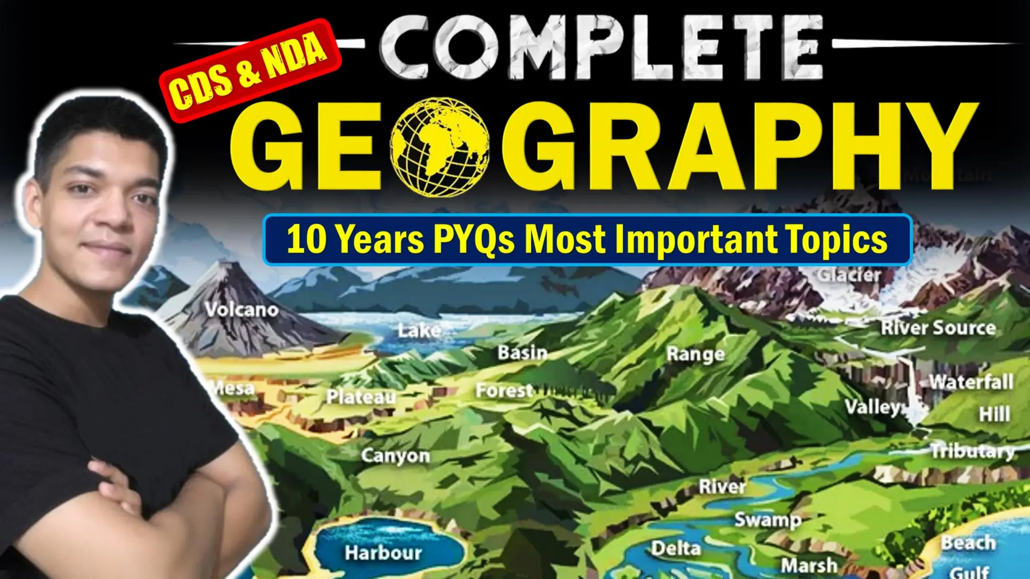
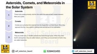
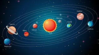
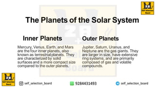
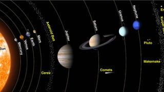
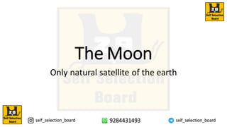
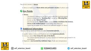
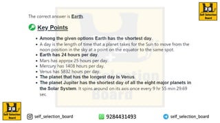
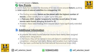
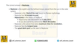
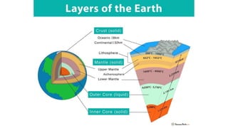
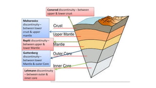
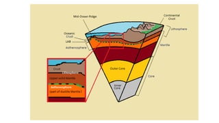
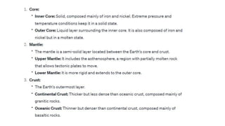
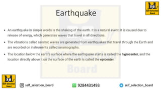
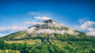
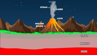
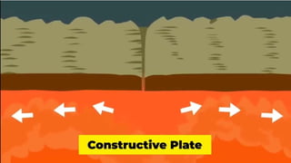
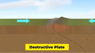
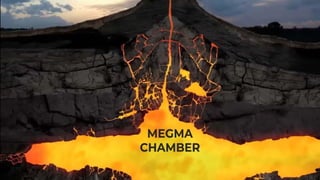
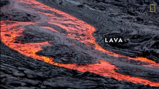
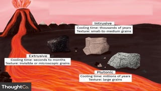
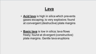
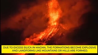
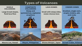
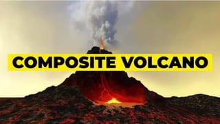
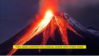
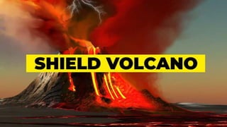
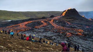
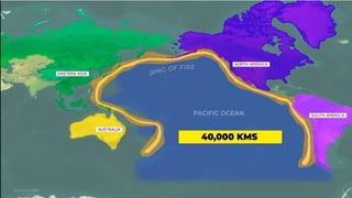
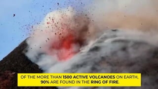
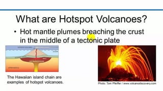
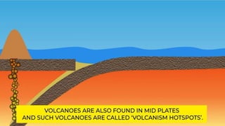
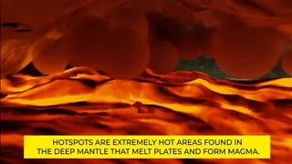
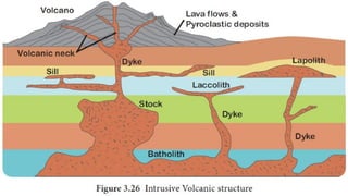
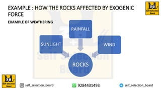
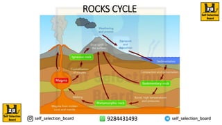
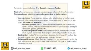
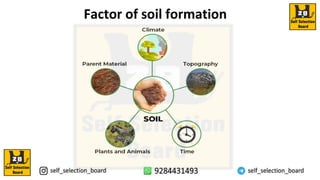
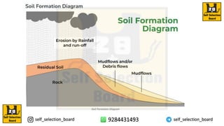
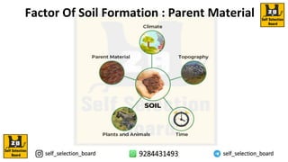
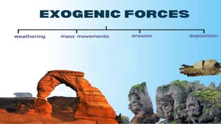
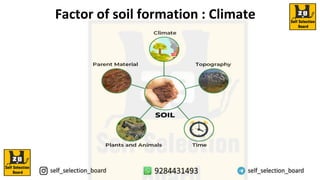
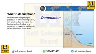
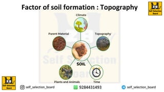
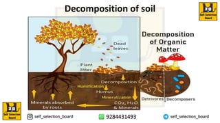
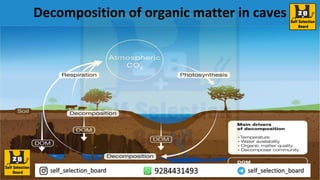
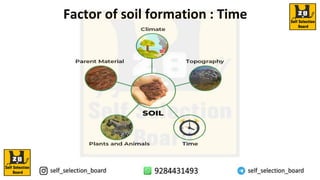
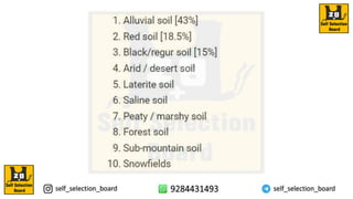
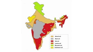
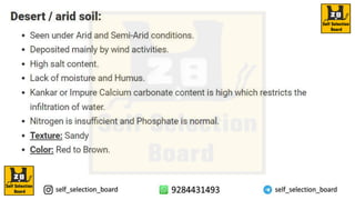
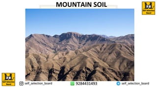
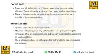
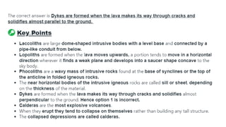
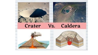
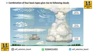
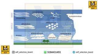
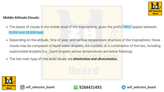
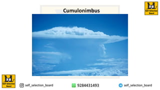
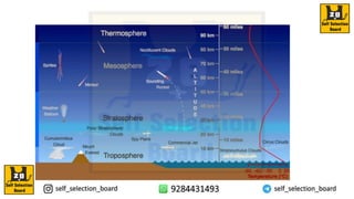
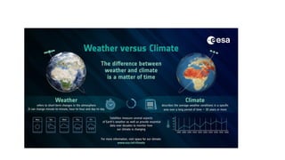
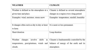
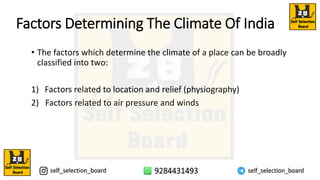
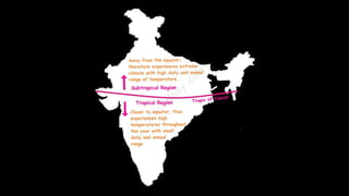
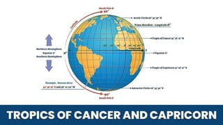
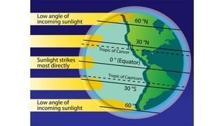
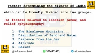
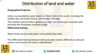
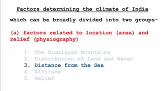
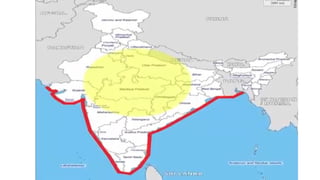
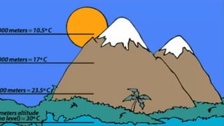
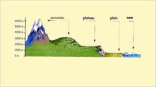
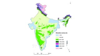
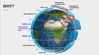
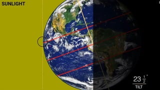
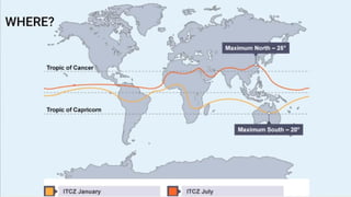
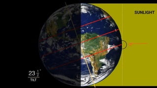
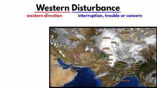
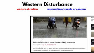
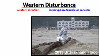
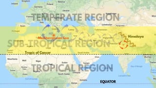
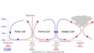
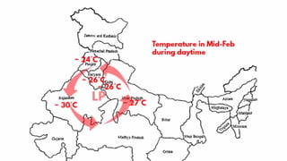
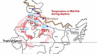
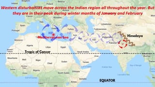
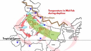
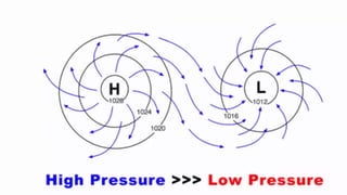
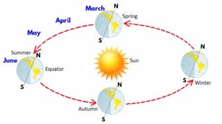
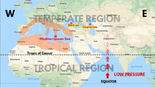
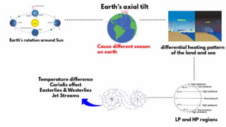
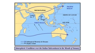
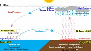
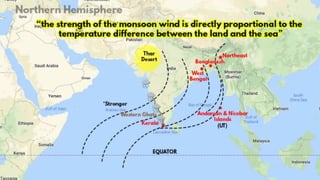
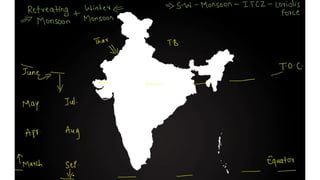
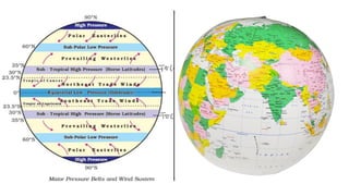
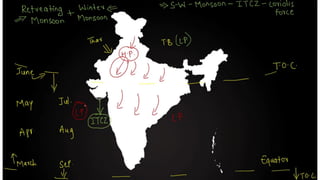
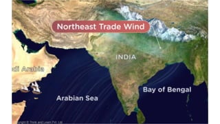
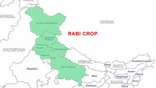
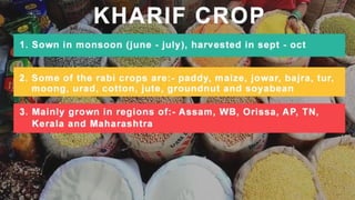
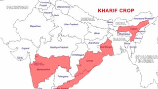
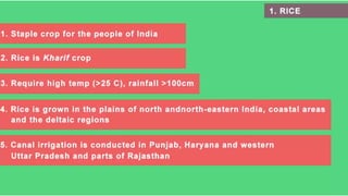
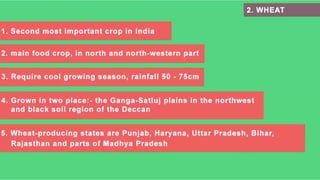
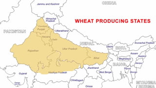
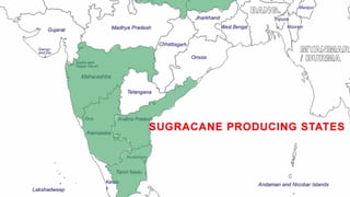
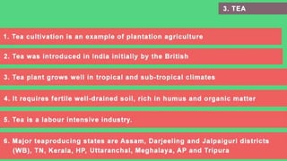
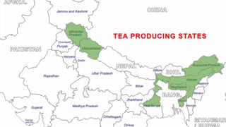
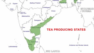
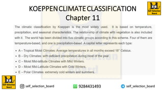
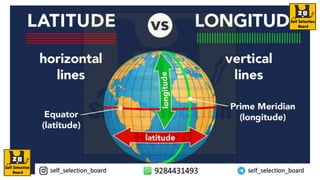
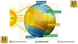
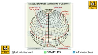
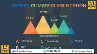
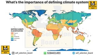
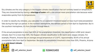
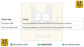
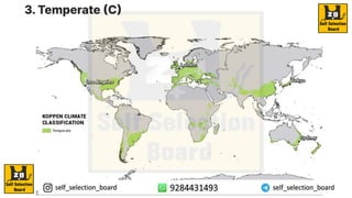
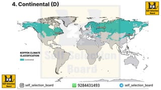
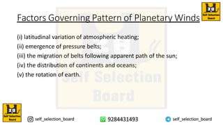
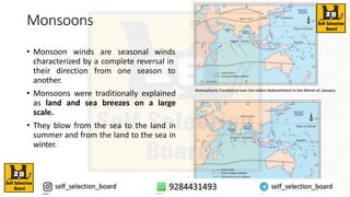
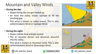
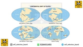
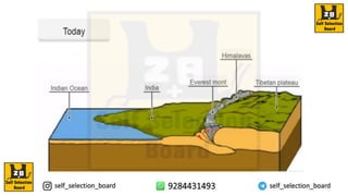
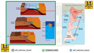
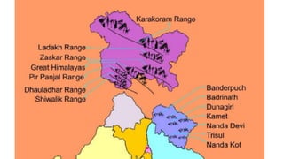
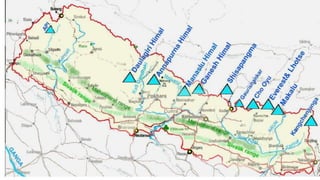
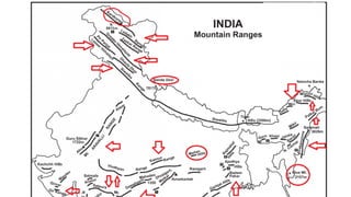
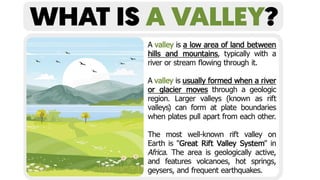
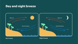
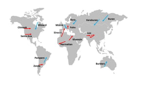
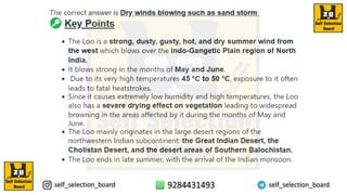
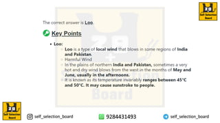
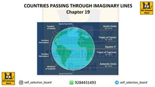
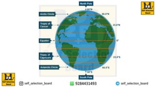
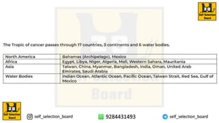
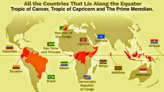
Geographical Important Topics
1.GTS Geological Time Scale
2.Origin of Universe
3.Interior of Earth
4.Volcanos
5.Rocks
6. Soil Formation
7.Landforms
8.Clouds
9.Atmospheric Layer
10.Climate
10.1 Ocean Current
11. Local Winds
12. Koppean Climate System
13. Himalayas
14.Lakes
15.Mountain Passes
17.Railway Zone
18.Winds & Local Winds
19.Tropic of Cancer, Capricorn &
Equator
20. World Straits
21.Vegetation
22.GMT Greenwich Mean Time
Chapter 1
Geological Time
Scale
Chapter 2
Origin Of Universe
Origin of the universe
The most popularargument
regarding the origin of the universe
is the Big Bang Theory. It is also
called expanding universe
hypothesis. Edwin Hubble, in 1920,
provided evidence that the universe
is expanding. As time passes,
galaxies move further and further
apart.
Nebula
A galaxy starts to form by
accumulation of hydrogen gas in the
form of a very large cloud called
nebula.
Milky Way Galaxy
Solar System
Formation and Evolution of the Solar
System
Nebular Hypothesis
The formation of the solar system is believed to
have started with a giant cloud of gas and dust,
known as the solar nebula. Over time, this nebula
collapsed and formed the Sun and the planets
through a process called accretion.
Planetary Differentiation
As the planets formed, heavier elements sank to
the core, while lighter elements rose to the surface.
This process, known as planetary differentiation,
resulted in the distinct layers within each planet.
Our solar system
Our Solar system consists of eight planets. The nebula
from which our Solar system is supposed to have been
formed, started its collapse and core formation some
time 5-5.6 billion years ago and the planets were formed
about 4.6 billion years ago. Our solar system consistsof
the sun (the star), 8 planets, 63 moons, millions of
smaller bodies like asteroids and comets and huge
quantity of dust-grains and gases.
Dwarf Planetsand Other Celestial
Bodies
1 Pluto - A Dwarf Planet
Pluto, once consideredthe ninth planet, has beenreclassifiedas a dwarf planet.
It is known for its elongated orbit and its moon, Charon.
2 Kuiper Belt and Oort Cloud
These regions contain a multitude of icy objects,including dwarf planets like
Eris, Haumea, and Makemake, along with a vast number of comets and other
small bodies.
Asteroids, Comets, and Meteoroids in
the Solar System
Asteroids
These rocky bodies primarily orbit the Sun within the asteroid belt, located between
Mars and Jupiter.
Comets
Comets are icy bodies that originate from the Kuiper Belt and Oort Cloud. When they
approach the Sun, they exhibit a striking coma and tail due to ice sublimation.
Meteoroids
They are small rocky or metallic particles that travel through space. When they enter
Earth's atmosphere, they are called meteors, and if they survive and land on Earth, they
are called meteorites.
Facts About Earth And Sun
A light year is a measure of distance and not of time.
Light travels at a speed of 300,000 km/second.
Considering this, the distances the light will travel in
one year is taken to be one light year. This equals to
9.461×10¹² km. The mean distance between the sun
and the earth is 149,598,000km. In terms of light
years, it is 8.311minutes.
The Planets of the Solar System
Inner Planets
Mercury, Venus, Earth, and Mars
are the four inner planets, also
known as terrestrial planets. They
are characterized by solid
surfaces and a more compact size
compared to the outer planets.
Outer Planets
Jupiter, Saturn, Uranus, and
Neptune are the gas giants. They
are larger in size, have extensive
ring systems, and are primarily
composed of gas and volatile
compounds.
The Moon
Only natural satellite of the earth
Introduction to the
Evolution of Earth
The evolution of Earth is a captivating journey that spans billions of years,
shaping the planet into what we know today. From its formation to the
emergence of life, the Earth has undergone remarkable transformations,
leading to the diversity and complexity we witness. This presentation will
delve into the distinct phases of Earth's evolution, exploring key events
and their implications for the planet's future.
Formation of the Earth
TheBirth of Our Planet
Approximately 4.6 billion years
ago, the Earth was formed
through the accumulation of
dust, gas, and other celestial
materials. This process led to
the creation of a molten mass,
which eventually cooled and
solidified, giving rise to the early
Earth.
TheSolar System's
Formation
The Earth's formation was part
of the larger process of the solar
system coming into existence.
Understanding the incredible
forces and energy involved in
this cosmic event is crucial to
comprehending the geological
and astronomical developments
that followed.
TheEarly Conditions
During its early years, the Earth
experienced intense heat and
volcanic activity. The
atmosphere gradually
developed, and the first oceans
began to accumulate, setting
the stage for the emergence of
life.
Geological Time Scale
Eons, Eras, and
Periods
The geologicaltime scale
categorizes Earth's history
into eons,eras, periods,and
epochs,providing a
framework for
understanding the
sequence of major events
and transitions that have
occurred over time.
Fossils and Dating
Techniques
Fossils and radioactive
dating methods allow
scientists to determine the
age of rock layers and the
fossilscontained within
them, providing invaluable
insights into the evolution of
life and the Earth itself.
Geological Events
and Changes
This scale also highlights
significantgeological
events, such as mass
extinctions,climate shifts,
and the formation of major
geologicalfeatures,offering
a comprehensive overview
of the Earth's dynamic
history.
How was the layered structure of
the
earth developed?
Evolution of Lithosphere
The earth was mostlyin a volatile stateduring its primordial stage. Due to gradual increase
in density the temperature inside has increased. As a re salt the material inside started
getting separated depending on their densities. This allowed heavier materials (like iron) to
sink towards the center of the earth and the lighter ones to move towards the surface. With
passageof time it cooled further and solidified and condensed into a smaller size. This later
led to the development of the outer surface in the form of a crust. During the formation of
the moon, due to the giant impact, the earth was further heated up. It is through the
process of differentiation that the earth forming material got separated into different layers.
Starting from the surface to the central parts, we have layers like the crust, mantle, outer
core and inner core. From the crust to the core, the density of the material increases. We
shall discuss in detail the properties of each of this layer in the next chapter.
Lithosphere
Evolution of Atmosphere and
Hydrosphere
There are three stages in the evolution of the present
atmosphere. The first stage is marked by the loss of
primordial atmosphere. In the second stage, the hot
interior of the earth contributed to the evolution of
the atmosphere. Finally, the composition of the
atmosphere was modified by the living world through
the process of photosynthesis.
The early atmosphere, with hydrogen and helium, is supposed
to have been stripped off as a result of the solar winds. This
happened not only in case of the earth, but also in all the
terrestrial planets, which were supposed to have lost their
primordial atmosphere through the impact of solar winds.
During the cooling of the earth, gases and water vapour were
released from the interior solid earth. This started the
evolution of the present atmosphere. The early atmosphere
largely contained water vapour, nitrogen, carbon dioxide,
methane, ammonia and very little of free oxygen.
The process through which the gases were outpoured from the interior
is called degassing. Continuous volcanic eruptions contributed water
vapour and gases to the atmosphere. As the earth cooled, the water
vapour released started getting condensed. The carbon dioxide in the
atmosphere got dissolved in rainwater and the temperature further
decreased causing more condensation and more rains. The rainwater
falling onto the surface got collected in the depressions to give rise to
oceans. The earth’s oceans were formed within 500 million years from
the formation of the earth.
Important Question(MCQ’S)
Answer : (a) 4.6 million years
The correctanswer is (a) Eons. Eons representthe longestduration in the geological time scale.
The geological time scale is divided into eons,which are further divided into eras, then periods,
epochs, and ages in descending order of duration.
(b) Planets between the sun and the belt of asteroids represents the inner planets. The inner
planets, also known as terrestrialplanets,include Mercury,Venus, Earth, and Mars.They are
locatedcloser to the Sun than the outer planets (Jupiter, Saturn, Uranus, and Neptune) and are
separated by the asteroidbelt, which lies between Mars and Jupiter.
Solar System:
https://www.youtube.com/watch?v=VKdD-30bra4&t=140s
Big Bang Theory:
https://www.youtube.com/watch?v=0O1SqJXXuHI
Black Hole:
https://www.youtube.com/watch?v=_35L481y4u4
Reference Video
Chapter3
Interior Of Earth
Source: NCERT
Earthquake
Important question(MCQ’S)
Chapter 4
Volcano
Hawaii Island(USA)
Hawaii Island(USA) Is A Example Of Hotspot Volcano
Mount Kilimanjaro(Tanzania)
Mount Fuji(Japan)
Chapter 5
ROCKS
Difference between basic and acidic lava
Basalt ROCKS Granite ROCKS
Introduction
IGNEOUS ROCKSS
TYPES BASED ON FORMATION
SEDIMENTARY ROCKSS
Which force is responsible for
weakening ROCKS?
EXAMPLE : HOW THE ROCKS AFFECTED BY EXOGENIC
FORCE
ROCKS
SUNLIGHT
RAINFALL
WIND
EXAMPLE OF WEATHERING
METAMORPHIC ROCKS
ROCKS CYCLE
ROCKSS
Important question(MCQ’S)
Chapter 6
Factor of soil formation
SOIL FORMATION
Factor Of Soil Formation : Parent Material
LAVA SOLID
ACIDIC (METAL
40%)
BASIC(METAL 60%)
ROCK
ACIDIC ROCK
BASIC ROCK
COOLING
1 mm Plus – GRAVEL 0.05 to 1 mm Plus – SAND 0.05 mm - Slit 0.005 mm – CLAY
ROCK WILL DECIDE OF SOIL PROPERTY
ROCK
WATER
HOLDING
CAPACITY
FEFRTILITY
COLOR OF
SOIL
TEXTURE
MINERAL
COMPOSIT
ION
ROCK
ACID ROCK(METALIC BASIC ROCK
GRANITE ROCK BASALT ROCK
Which force is responsible for
convert the rock into soil?
Factor of soil formation : Climate
EXAMPLE : HOW THE ROCK TURN INTO SOIL BY USING
EXOGENIC FORCE
ROCK
SUNLIGHT
RAINFALL
WIND
EXAMPLE OF WEATHERING
IMPACT ON ROCK
BREAKDOWN PROCESS WEATHERING
WEATHERING
• Weathering is when rocks and other stuff on the Earth's surface
slowly break down over time. It happens because of things like wind,
rain, and changes in temperature.
Transportation
• The transportation of soil refers to the movement of soil particles from one place
to another by natural agents such as water, wind, ice, or gravity.
What is denudation?
• Denudation is the geological processes in which moving water, ice, wind, and waves erode the
Earth's surface, leading to a reduction in elevation and in relief of landforms and landscapes.
What is denudation?
Denudation is the geological
processes in which moving water,
ice, wind, and waves erode the
Earth's surface, leading to a
reduction in elevation and in relief
of landforms and landscapes.
Factor of soil formation : Topography
Soil Formation : Topography
Decomposition of soil
Decomposition of organic matter in caves
Humus is dark, organic material that forms in soil when plant and animal matter decays.
Factor of soil formation : Time
Soil Formation : Time
The soils, which take a lot of time, lead to the formation of mature soil,
whereas the soils formed in less time lead to the formation of immature soil.
CLASSIFICATION OF SOILS IN INDIA
ALLUVIAL SOIL
RED SOIL
BLACK SOIL
DESERT/ARID SOIL
LATERITE SOIL
SALINE SOIL
PEATY/MARSHY SOIL
FOREST SOIL
MOUNTAIN SOIL
SNOWFIELDS
Important question(MCQ’S)
Chapter7
Chapter 8
CLOUDS
CLOUD FORMATION
FACTORS FOR CLOUD FORMATION
TYPES
⮚ Combination of four basic types give rise to following clouds
CIRRUS
CIRROSTRATUS
Cirrocumulus
Altostratus
Altocumulus
Nimbostratus
Stratocumulus
Stratus
Cumulus
Cumulonimbus
Chapter 9
ATMOSPHERIC LAYERS
INTRODUCTION
LAYERS OF ATMOSPHERE
Chapter 9
Factors Determining The Climate Of India
• The factors which determine the climate of a place can be broadly
classified into two:
1) Factors related to location and relief (physiography)
2) Factors related to air pressure and winds
Factors Related To Location And Relief
The Himalayan Mountains
Geographical Barrier:
The Himalayan mountains in the north serve as a significant geographical barrier.
They act as a shield against the cold northern winds originating near the Arctic Circle and
blowing across central and eastern Asia.
Effect on Winter Climate:
Due to the presence of the Himalayas, the Indian subcontinent experiences comparatively
milder winters compared to Central Asia.
The mountains block the intrusion of cold air masses from the north, helping to moderate
temperatures in the region.
Distribution of land and water
Geographical Features:
India is surrounded by water bodies on three sides in the south, including the
Arabian Sea, the Indian Ocean, and the Bay of Bengal.
The northern part of India is girdled by a high and continuous mountain wall,
primarily the Himalayan mountain range.
Differential Heating:
Water heats up and cools down more quickly than land.
This differential heating between land and water creates different air pressure
zones in and around the Indian subcontinent.
Distance from the sea
Moderating Influence of the Sea:
The sea exerts a moderate influence on climate due to its ability to absorb and release heat more
slowly than land.
Coastal areas tend to experience more moderate temperatures compared to inland regions due to
the proximity to the sea.
Continentality:
Continentality refers to the effect of distance from the sea on climate conditions.
As the distance from the sea increases, the moderating influence of the sea decreases.
Regions farther from the sea tend to have more extreme weather conditions, characterized by very
hot summers and very cold winters.
Extreme Weather Conditions:
Inland or continental regions experience greater temperature variations throughout the year.
Summers in these areas can be excessively hot due to the absence of a moderating maritime
influence.
Similarly, winters in continental regions tend to be colder as there is less heat retention compared to
coastal areas.
Impact on Climate Patterns:
Distance from the sea plays a significant role in shaping climate patterns and weather conditions in
different regions.
It influences factors such as temperature, humidity, and precipitation, contributing to variations in
climate across a country or continent.
Altitude
Effect of Elevation on Temperature:
Temperature decreases with an increase in elevation or altitude.
Places located at higher elevations, such as mountainous regions, tend to be cooler than those at
lower elevations, such as plains or valleys.
Comparison of Agra and Darjeeling:
Agra and Darjeeling are located at the same latitude but differ significantly in elevation.
Agra, situated on the plains, experiences warmer temperatures compared to Darjeeling, which is
located in the mountains.
In January, the temperature in Agra is 16℃, whereas it is only 4℃ in Darjeeling.
This difference in temperature can be attributed to the higher elevation of Darjeeling, where cooler
temperatures prevail due to its mountainous terrain.
Temperature Variation with Latitude and Elevation:
While latitude influences the overall climate patterns and seasonal variations, elevation plays a
crucial role in determining local temperature differences within a region.
Higher elevations experience cooler temperatures regardless of their latitude, leading to
variations in temperature between locations situated at similar latitudes but different elevations.
Impact on Local Climate:
The temperature variation between Agra and Darjeeling highlights how elevation can significantly
impact local climate conditions.
This difference in temperature influences various aspects of life, including agriculture, tourism,
and daily activities, in these regions.
Relief
Impact on Temperature:
Relief or the physical features of the land significantly affect temperature patterns in a region.
Higher elevations tend to have cooler temperatures, while lower-lying areas experience warmer
temperatures.
Effect on Air Pressure and Wind:
Relief influences air pressure and wind patterns.
Differences in elevation create variations in air pressure, leading to the movement of air masses.
Wind direction and speed can be influenced by the presence of mountains, valleys, and other
geographical features.
Role in Rainfall Distribution:
Relief plays a crucial role in the distribution of rainfall.
Windward sides of mountain ranges, such as the Western Ghats and Assam, receive high rainfall due to orographic
lifting, where moist air is forced to rise and condense, resulting in precipitation.
In contrast, leeward or downwind areas may experience less rainfall due to the rain shadow effect, where
descending air leads to dry conditions.
Examples from India:
The windward sides of the Western Ghats and Assam receive significant rainfall during the monsoon season (June
to September) due to their orographic characteristics.
In contrast, the southern plateau remains relatively dry due to its leeward position along the Western Ghats,
experiencing less rainfall compared to windward areas.
Overall Impact on Climate:
Relief features such as mountains, plateaus, and valleys have a profound impact on the climate of a region,
influencing temperature, precipitation, and wind patterns.
Trade Winds
Inter-Relationship Between ITCZ and Jet Streams:
Meteorologists observe an inter-relationship between the northward shift of the equatorial trough
(ITCZ) and the withdrawal of the westerly jet stream from over the North Indian plain.
There is believed to be a cause-and-effect relationship between the two phenomena.
Effect on Wind Patterns:
The ITCZ, being a zone of low pressure, attracts winds from different directions.
The maritime Tropical air mass (mT) from the southern hemisphere crosses the equator and reaches
the low-pressure area in a general southwesterly direction, forming the southwest monsoon.
Southwest Monsoon Formation:
The moist air current associated with the southwest monsoon originates from the maritime Tropical
air mass and is a result of the northward shift of the ITCZ.
Inter Tropical Convergence Zone
ITCZ Description:
The ITCZ is described as a broad trough of low pressure located in equatorial latitudes.
It is characterized by the convergence of the northeast and southeast trade winds, where air
tends to ascend.
Movement of ITCZ:
The ITCZ is noted to lie almost parallel to the equator but shifts north or south with the apparent
movement of the sun.
In July, the ITCZ is positioned around 20°N – 25°N latitude, specifically over the Gangetic plain,
where it is referred to as the monsoon trough.
Impact on Monsoon:
The presence of the monsoon trough enhances the development of thermal lows over north and
northwest India.
As a result of this shift in the ITCZ, the trade winds of the Southern Hemisphere cross the equator
between 40°E and 60°E longitude and change direction, blowing from southwest to northeast.
This change in wind direction, influenced by the Coriolis force, gives rise to the southwest monsoon,
which brings significant rainfall to the Indian subcontinent.
Seasonal Changes:
During winter, the ITCZ moves to the Southern Hemisphere, leading to a reversal of winds from
northeast to south and southwest.
These winds are known as the northeast monsoons.
Western Disturbance
and Jet Stream
Jet Stream And Upper Air Circulation
Dominance of Westerly Flow:
Upper air circulation in the region is primarily dominated by westerly winds.
Westerly Winds in Western and Central Asia:
Western and Central Asia experience westerly winds at altitudes of 9-13 km in the troposphere, blowing from
west to east.
Formation of Jet Streams:
These westerly winds form jet streams, narrow belts of high-altitude winds in the troposphere.
The subtropical westerly jet streams are located approximately over 27°-30° North latitude.
Effect of Himalayas and Tibetan Plateau:
In the winter season, the Himalayas and Tibetan Plateau obstruct the flow of westerly jet streams, leading to
their bifurcation into two branches.
One branch flows to the north of the Tibetan highlands, while the other flows eastward, south of the Himalayas.
Influence on Winter Weather in India:
The southern branch of the jet stream, flowing south of the Himalayas, has a
significant impact on winter weather conditions in India.
This branch affects temperature, precipitation, and atmospheric stability,
influencing winter weather patterns across the country.
Speed of Jet Streams:
The speed of jet streams varies seasonally, ranging from about 110 km/hr in
summer to approximately 184 km/hr in winter.
Western cyclonic disturbance and tropical cyclones
Western Cyclonic Disturbances:
Western cyclonic disturbances are weather phenomena occurring during the winter months,
brought in by the westerly flow from the Mediterranean region.
They typically affect the weather of the north and northwestern regions of India.
Origin and Impact:
Tropical cyclones originate over the Bay of Bengal and the Indian Ocean.
These disturbances are part of the easterly flow and impact the coastal regions of the country,
particularly Tamil Nadu, Andhra Pradesh, and Odisha coast.
Tropical cyclones are characterized by high wind velocity and torrential rains, making them highly
destructive.
Distribution and Seasonality:
Western cyclonic disturbances primarily affect the north and northwestern regions of India during the winter
months.
Tropical cyclones occur mainly during the pre-monsoon and monsoon seasons, affecting the coastal regions of the
country.
Impact on Weather and Climate:
Western cyclonic disturbances bring rainfall and fluctuating weather conditions to the affected regions.
Tropical cyclones can cause extensive damage to property, infrastructure, and agriculture due to their strong
winds and heavy rainfall.
Mitigation and Preparedness:
Effective forecasting and early warning systems are essential for mitigating the impact of cyclonic disturbances.
Preparedness measures, such as evacuation plans and disaster response strategies, are crucial for minimizing the
loss of life and property during cyclone events.
Mechanism of weather in summer season
Surface Pressure And Winds
Summer Season Dynamics:
During the summer season, the sun's position shifts northwards, leading to changes in wind
circulation patterns over the Indian subcontinent.
Inter-Tropical Convergence Zone (ITCZ):
The ITCZ, a low-pressure belt near the surface, shifts northwards, roughly parallel to the Himalayas,
between 20°N and 25°N by the middle of July.
Withdrawal of Westerly Jet Streams:
The westerly jet streams also withdraw from the Indian region around the same time as the
northward shift of the ITCZ.
Jet Streams And Upper Air Circulation
An easterly jet stream flows over the southern part of the peninsula in June and
has a maximum speed of 90 km/hr.. In August it is confined to 15°N latitude and in
September up to 22°N. These easterly jet streams do not extend to the north of
30°N latitude in the upper atmosphere.
Indian Monsoon
Western Ghat
Retreating Monsoon
Seasons in India
Types of Crops
OCEANCURRENTS
Chapter 10
Q&A
KOEPPENCLIMATECLASSIFICATION
Chapter 11
Savana/Dry Winter Savana/Dry Summer
Semi Arid or Steppe
Chapter 13
Wind
System
Planetary Winds
Introduction
• The air in motion is called wind.
• Air is set in motion due to the differences in
atmospheric pressure.
• Wind blows from high pressure to low
pressure.
• Wind measurement instruments are :
• Wind vane on weather cock - measures
wind direction
• Anemometer - measures wind velocity
Types of Winds
Winds can be classified in three types :
1. Primary Winds
2. Secondary Winds
3. Tertiary Winds
Primary Winds
• Other names: Prevailing Winds/Planetary Winds/Permanent Winds/Invariable
Winds
• Permanent - blow constantly in same direction throughout the year
• Planetary Winds - flow from one latitude to another latitude (larger areas on
earth)
• There are three main types primary winds :
i. Trade winds
ii. Westerlies and
iii. Polar Easterlies
Trade Winds
• Flow in Hadley Cells in both the hemispheres.
• Flow from Sub tropical High Pressure Belts
towards Equatorial Low Pressure Belt between
30° N and 30° S latitudes.
• Flow towards the equator from the north-east
in Northern Hemisphere and from the south-
east in Southern Hemisphere.
• Trade winds are descending and stable at the
surface of their origin (Sub tropical High
Pressure Belts)
• On their way to Equator, they get warm and
moist and near Equator they converge, rise and
cause heavy rains.
Westerlies
• Flow in Ferrel Cells in both the hemispheres.
• Flow from Sub tropical High Pressure Belts
towards Sub-polar Low Pressure Belt
between 30° and 60° latitudes in both the
hemispheres.
• They blow from southwest to north-east in
the northern hemisphere and north-west to
south-east in the southern hemisphere.
Westerlies
• The are more constant and stronger in
the southern hemisphere because there
is no large landmasses to interrupt them.
• The westerlies are best developed
between 40° and 65°S latitudes.
• These latitudes are often called:
• Roaring Forties
• Furious Fifties
• Shrieking Sixties
Polar Easterlies
• These dry & cold winds flow in Polar Cells
in both the hemispheres.
• Flow from Polar High Pressure Belts
towards Sub-polar Low Pressure Belt
between 90° (Poles) and 60° latitudes in
both the hemispheres.
• It blows from north-east to south-west
direction in Northern Hemisphere
and south-east to the north-west in
Southern Hemisphere.
Factors Governing Pattern of Planetary Winds
(i) latitudinal variation of atmospheric heating;
(ii) emergence of pressure belts;
(iii) the migration of belts following apparent path of the sun;
(iv) the distribution of continents and oceans;
(v) the rotation of earth.
WIND SYSTEM
CLIMATOLOGY (GEOGRAPHY)
Seasonal Winds
Types of Winds
Winds can be classified in three types :
1. Primary Winds
2. Secondary Winds
3. Tertiary Winds
Secondary Winds
• Also known as Seasonal, Periodic or Variable winds
• Seasonal Winds - these winds change their direction in different seasons. For
example, monsoons in India.
• Periodic Winds as these winds keep flowing periodically. For example, Land and
sea breeze, mountain and valley breeze.
Monsoons
• Monsoon winds are seasonal winds
characterized by a complete reversal in
their direction from one season to
another.
• Monsoons were traditionally explained
as land and sea breezes on a large
scale.
• They blow from the sea to the land in
summer and from the land to the sea in
winter.
Land and Sea Breezes
• During day:
• Land heats up faster and becomes warmer than
the sea - air rises & low-pressure area is created.
• Sea is relatively cool & the pressure over sea is
relatively high.
• Thus, pressure gradient is from sea to land - sea breeze
blows.
• At night:
• Reversal of condition takes place.
• Land loses heat faster than the sea and is cooler –
air is dense – high pressure
• Pressure gradient is from land to sea - land breeze
blows
Mountain and Valley Winds
• During the day:
• Slopes facing the sun get heated up.
• Air from the valley moves upslope to fill the
resulting gap.
• This wind is known as valley breeze. This is also
called Anabatic Wind or Upslope Wind.
• During the night:
• Slopes radiate heat and get cooled.
• The air become denser and descends downhill
into the valley.
• This wind is known as mountain wind. This is also
called Katabatic Wind or Downslope Wind.
Anabatic & Katabatic Winds - Implications
• Anabatic - Warm wind which blows up a steep
slope or mountain side, driven by heating of the
slope through insolation
• Typically occur during the daytime in calm
sunny weather.
• Useful to soaring glider pilots who can use them
to increase the aircraft's altitude.
• Detrimental to the maximum downhill speed of cyclists.
• Air rises to reach a height where it cools adiabatically to below its dew point.
• Commonly result into formation of cumulus clouds & producing rain or
even thunderstorms.
Anabatic & Katabatic Winds - Implications
• Katabatic - Originates at night from
radiational cooling of air on top of a plateau,
mountain, glacier, or a hill
• The dense air drains downwards under
gravity.
• Also known as Fall winds
• In areas where fall winds occur, homes and
orchards are situated on hillslopes above the
lowlands where the cold air accumulates.
Local winds
• These are also called Tertiary Winds.
• These blow only during a particular period of the day or year in a small area.
• Local differences in temperature and pressure produce local winds.
• Such winds are local in extent and are confined to the lowest levels of the
troposphere.
• For example, Loo, Mistral, Foehn, Bora etc.
Local Winds
of the World
Types of Winds
Winds can be classified in three types :
1. Primary Winds
2. Secondary Winds
3. Tertiary Winds
Local winds
• These are also called Tertiary Winds.
• These blow only during a particular period of the day or year in a small area.
• Local differences in temperature and pressure produce local winds.
• Such winds are local in extent and are confined to the lowest levels of the
troposphere.
• For example, Loo, Mistral, Foehn, Bora etc.
Thermal classification of Local Winds
• Warm/hot & dry local winds:
• Type 1: originating from tropical deserts
during summers
• Are hot, dry & dusty
• Usually bring heat waves
• Ex. – Loo, Harmattan, Sirocco
Thermal classification of Local Winds
• Type 2: originating on the leeward side of mountains due to adiabatic
heating of sinking air when it moves from top to valley
• Usually bring favorable conditions
• Ex. – Chinook, Foehn, Zonda
Thermal classification of Local Winds
• Cold & dry local winds:
• Type 1: originating from polar region
• Ex – Blizzards
• Type 2: originating from high mountain ranges in winters
• Ex – Mistral, Bora, Pampero
Continent wise
Classification
of Local Winds
NORTH AMERICA
• Chinook
• Blizzards
• Norther
• Norte
• Santa Ana
Local winds Nature Region
Chinook
(SW)
• Means Snow-eater
• Warm & dry wind
• Beneficial wind as it keeps the grasslands to the
East of the Rockies clear of snow during much of
the winter.
Blows along the
Eastern slope of the
Rockies.
On western slope they
are moist.
Blizzard
(NW)
• Cold wind.
• Creates severe snow storm (white out).
Blows in Canada, USA,
Siberia, etc.
Norte • strong cold wind blows in Mexico
along the Gulf of
Mexico
Santa-Ana
winds
• Warm, dry & strong wind flow west out of the
Great Basin, through
upper Mojave desert
to California
Local winds of North America
Pampero (SW)
• Cold wind
• Blows in Argentina and
Uruguay
Zonda (W)
• Warm & dry
• Foehn winds on the
eastern slope of the Andes
in Argentina & Uruguay
SOUTH AMERICA
• Fohn
• Mistral
• Levante
• Bora
• Etesian
Local winds of Europe
Local winds Nature Region
Foehn or Fohn • strong, dry and warm wind.
• Beneficial wind as it affects the snow, makes
the weather pleasant and helps in early
ripening of the grapes.
Blows along the Northern
slope of Alps.
Mistral
(North/NW)
• Very cold and dry with a high speed.
• It is Harmful wind.
Blows from the Alps over
France towards
Mediterranean Sea.
Local winds of Europe
Local winds Nature Region
Levante/
Levanter
• moist, damp and rainy Blows near Mediterranean Sea
and southern France & Spain
Bora
(NE)
• Cold, dry, gusty wind (can reach speeds
of more than 100 km/h)
Blows near the Adriatic Sea
from the mountains
Etesian • Also known as meltemia, or meltem
• strong, dry winds
Blows near the Aegean Sea
• Sirocco
• Khamsin
• Haboob
• Harmattan (Doctor wind)
• Berg
Local winds of Africa
Local
winds
Nature Region
Sirocco
(South
or SE)
• warm, dry and dusty wind.
• also known as blood rain because of its
reddish sand brought along with it from the
Sahara desert.
• It is much destructive to agricultural
and
fruit crops.
It blows in Northerly direction from
Sahara desert and after crossing
over the Mediterranean sea reaches
Italy, Spain etc.
Khamsin • It is a sirocco wind.
• Dry, hot, sandy wind.
Blows in Egypt & over Red Sea
Haboob • Violent wind, raises sandstorms
• It lacks a specific direction.
Blows in North Africa
Local winds of Africa
Loca
l
wind
s
Nature Region
Harmattan
(NE)
• dry and dusty north-easterly trade wind
• arrival of Harmattan makes weather
pleasant suddenly in the Western coast of
Africa. Therefore, it is called Doctor there.
Blows blows from the
Sahara Desert over the
West Africa
Berg • South African name for a foehn wind
• A hot dry wind blowing from the
mountainous interior to the
coast.
blow from the Kalahari High to a
coastal low-pressure area
• Buran
• Karaburan
• Simoon
• Yoma
• Loo
Local winds
Local winds Nature Region
Buran • In summer, it is a hot, dry,
wind, bringing sandstorms;
• In winter, it is bitterly cold and often
accompanied by blizzards
a wind which blows across eastern
Asia
Karaburan • dust-laden fast blowing winds. Blows in the central Aisa.
Simoom • strong, dry, dust-laden wind. Blows in Arabian desert.
Yoma • warm and dry wind. Blows in Japan
Loo • hot and dry wind.
• sometimes called Heat-wave.
Blows in the Northern India from
the North-west.
Brickfielder
• hot and dry wind in
Southern Australia
HOT WINDS
CHINOOK(USA) LOO(INDIA)
FOEHN(SWITZERLAND) KHAMSIN(EGYPT)
BLACK ROLLER(USA) NORWESTER(NEWZEALAND)
SANTA ANA(USA) YOMA(JAPAN)
KARABURUN(CHINA) BRICKFIELDER(AUSTRALIA)
9
SIROCCO(NORTH AFRICA) SHAMAL(IRAN)
COLD WINDS
MISTRAL(FRANCE) LEVANTER(SPAIN)
ZONDA(CHILLI) BLIZZARD(CANADA)
BORA(ITALY) PAMPERO (ARGENTINA)
BURRAN(RUSSIA) GREGALE(GREECE)
Important Question(MCQ’S)
Chapter 15
Mountain
Passes
Bannihal Pass
• Jawahar tunnel
• Channai tunnel
MOUNTAIN PASSES IN INDIA
Mintaka pass
Karakoram pass
Aghill pass
Shipki La pass
Mana pass
Niti valley
Lipulekh pass
Barlacha La pass
Rohtang pass
Tri Junction Pass
Chenab River Origin
(Chandra and Bhagha)
(Ravi & Beas Origin)
(Sutlej River Pass)
Nathula pass
Jelep La pass
Buma La pass
Sela pass
Bomdi La pass
Yongyyab La
Diphu pass
Tuzo pass
Chang La Pass
Baralacha Pass
Introduction
Note: - The Lahaul and Spiti district in the Indian state of Himachal Pradesh consists of the two formerly separate districts of Lahaul
(Chumbi Valley)
Nathula pass
Jelep La pass
Buma La pass
Sela pass
Bomdi La pass
Yongyyab La
Diphu pass
Tuzo pass
(Tista River)
THAL GHAT (KASARA GHAT)
Chapter 16
Continental Drift Theory &
Mountain Ranges of India
Continental Drift Theory
HIMALAYAS
TYPES OF HIMALAYAS
Kangra Valley
Kathmandu Valley
Chapter 17
RAILWAY ZONES
Chapter 18
LOCAL WINDS
WINDS
HOT WINDS COLD WINDS
HOT WINDS
CHINOOK(USA) LOO(INDIA)
FOEHN(SWITZERLAND) KHAMSIN(EGYPT)
BLACK ROLLER(USA) NORWESTER(NEWZEALAND)
SANTA ANA(USA) YOMA(JAPAN)
KARABURUN(CHINA) BRICKFIELDER(AUSTRALIA)
9
SIROCCO(NORTH AFRICA) SHAMAL(IRAN)
COLD WINDS
MISTRAL(FRANCE) LEVANTER(SPAIN)
ZONDA(CHILLI) BLIZZARD(CANADA)
BORA(ITALY) PAMPERO (ARGENTINA)
BURRAN(RUSSIA) GREGALE(GREECE)
HARMATTAN(DOCTAR WINDS)(WEST AFRICA)
Important Question(MCQ’S)
COUNTRIES PASSING THROUGH IMAGINARY LINES
Chapter 19
TROPIC OF CANCER
TROPIC OF CANCER
EQUATOR
EQUATOR
TROPIC OF CAPRICON
PYQs
Chapter 22
Geological Time
Scale
Complete Geography Youtube-pages.pdf. pagar

Complete Geography Youtube-pages.pdf. pagar

  • 2.
    Geographical Important Topics 1.GTSGeological Time Scale 2.Origin of Universe 3.Interior of Earth 4.Volcanos 5.Rocks 6. Soil Formation 7.Landforms 8.Clouds 9.Atmospheric Layer 10.Climate 10.1 Ocean Current 11. Local Winds 12. Koppean Climate System 13. Himalayas 14.Lakes 15.Mountain Passes 17.Railway Zone 18.Winds & Local Winds 19.Tropic of Cancer, Capricorn & Equator 20. World Straits 21.Vegetation 22.GMT Greenwich Mean Time
  • 3.
  • 4.
  • 15.
  • 16.
  • 17.
    Origin of theuniverse The most popularargument regarding the origin of the universe is the Big Bang Theory. It is also called expanding universe hypothesis. Edwin Hubble, in 1920, provided evidence that the universe is expanding. As time passes, galaxies move further and further apart.
  • 20.
    Nebula A galaxy startsto form by accumulation of hydrogen gas in the form of a very large cloud called nebula.
  • 21.
  • 22.
  • 23.
    Formation and Evolutionof the Solar System Nebular Hypothesis The formation of the solar system is believed to have started with a giant cloud of gas and dust, known as the solar nebula. Over time, this nebula collapsed and formed the Sun and the planets through a process called accretion. Planetary Differentiation As the planets formed, heavier elements sank to the core, while lighter elements rose to the surface. This process, known as planetary differentiation, resulted in the distinct layers within each planet.
  • 25.
    Our solar system OurSolar system consists of eight planets. The nebula from which our Solar system is supposed to have been formed, started its collapse and core formation some time 5-5.6 billion years ago and the planets were formed about 4.6 billion years ago. Our solar system consistsof the sun (the star), 8 planets, 63 moons, millions of smaller bodies like asteroids and comets and huge quantity of dust-grains and gases.
  • 28.
    Dwarf Planetsand OtherCelestial Bodies 1 Pluto - A Dwarf Planet Pluto, once consideredthe ninth planet, has beenreclassifiedas a dwarf planet. It is known for its elongated orbit and its moon, Charon. 2 Kuiper Belt and Oort Cloud These regions contain a multitude of icy objects,including dwarf planets like Eris, Haumea, and Makemake, along with a vast number of comets and other small bodies.
  • 29.
    Asteroids, Comets, andMeteoroids in the Solar System Asteroids These rocky bodies primarily orbit the Sun within the asteroid belt, located between Mars and Jupiter. Comets Comets are icy bodies that originate from the Kuiper Belt and Oort Cloud. When they approach the Sun, they exhibit a striking coma and tail due to ice sublimation. Meteoroids They are small rocky or metallic particles that travel through space. When they enter Earth's atmosphere, they are called meteors, and if they survive and land on Earth, they are called meteorites.
  • 30.
    Facts About EarthAnd Sun A light year is a measure of distance and not of time. Light travels at a speed of 300,000 km/second. Considering this, the distances the light will travel in one year is taken to be one light year. This equals to 9.461×10¹² km. The mean distance between the sun and the earth is 149,598,000km. In terms of light years, it is 8.311minutes.
  • 32.
    The Planets ofthe Solar System Inner Planets Mercury, Venus, Earth, and Mars are the four inner planets, also known as terrestrial planets. They are characterized by solid surfaces and a more compact size compared to the outer planets. Outer Planets Jupiter, Saturn, Uranus, and Neptune are the gas giants. They are larger in size, have extensive ring systems, and are primarily composed of gas and volatile compounds.
  • 34.
    The Moon Only naturalsatellite of the earth
  • 37.
    Introduction to the Evolutionof Earth The evolution of Earth is a captivating journey that spans billions of years, shaping the planet into what we know today. From its formation to the emergence of life, the Earth has undergone remarkable transformations, leading to the diversity and complexity we witness. This presentation will delve into the distinct phases of Earth's evolution, exploring key events and their implications for the planet's future.
  • 38.
    Formation of theEarth TheBirth of Our Planet Approximately 4.6 billion years ago, the Earth was formed through the accumulation of dust, gas, and other celestial materials. This process led to the creation of a molten mass, which eventually cooled and solidified, giving rise to the early Earth. TheSolar System's Formation The Earth's formation was part of the larger process of the solar system coming into existence. Understanding the incredible forces and energy involved in this cosmic event is crucial to comprehending the geological and astronomical developments that followed. TheEarly Conditions During its early years, the Earth experienced intense heat and volcanic activity. The atmosphere gradually developed, and the first oceans began to accumulate, setting the stage for the emergence of life.
  • 39.
    Geological Time Scale Eons,Eras, and Periods The geologicaltime scale categorizes Earth's history into eons,eras, periods,and epochs,providing a framework for understanding the sequence of major events and transitions that have occurred over time. Fossils and Dating Techniques Fossils and radioactive dating methods allow scientists to determine the age of rock layers and the fossilscontained within them, providing invaluable insights into the evolution of life and the Earth itself. Geological Events and Changes This scale also highlights significantgeological events, such as mass extinctions,climate shifts, and the formation of major geologicalfeatures,offering a comprehensive overview of the Earth's dynamic history.
  • 40.
    How was thelayered structure of the earth developed?
  • 41.
    Evolution of Lithosphere Theearth was mostlyin a volatile stateduring its primordial stage. Due to gradual increase in density the temperature inside has increased. As a re salt the material inside started getting separated depending on their densities. This allowed heavier materials (like iron) to sink towards the center of the earth and the lighter ones to move towards the surface. With passageof time it cooled further and solidified and condensed into a smaller size. This later led to the development of the outer surface in the form of a crust. During the formation of the moon, due to the giant impact, the earth was further heated up. It is through the process of differentiation that the earth forming material got separated into different layers. Starting from the surface to the central parts, we have layers like the crust, mantle, outer core and inner core. From the crust to the core, the density of the material increases. We shall discuss in detail the properties of each of this layer in the next chapter.
  • 42.
  • 43.
    Evolution of Atmosphereand Hydrosphere There are three stages in the evolution of the present atmosphere. The first stage is marked by the loss of primordial atmosphere. In the second stage, the hot interior of the earth contributed to the evolution of the atmosphere. Finally, the composition of the atmosphere was modified by the living world through the process of photosynthesis.
  • 45.
    The early atmosphere,with hydrogen and helium, is supposed to have been stripped off as a result of the solar winds. This happened not only in case of the earth, but also in all the terrestrial planets, which were supposed to have lost their primordial atmosphere through the impact of solar winds. During the cooling of the earth, gases and water vapour were released from the interior solid earth. This started the evolution of the present atmosphere. The early atmosphere largely contained water vapour, nitrogen, carbon dioxide, methane, ammonia and very little of free oxygen.
  • 46.
    The process throughwhich the gases were outpoured from the interior is called degassing. Continuous volcanic eruptions contributed water vapour and gases to the atmosphere. As the earth cooled, the water vapour released started getting condensed. The carbon dioxide in the atmosphere got dissolved in rainwater and the temperature further decreased causing more condensation and more rains. The rainwater falling onto the surface got collected in the depressions to give rise to oceans. The earth’s oceans were formed within 500 million years from the formation of the earth.
  • 47.
  • 48.
    Answer : (a)4.6 million years
  • 49.
    The correctanswer is(a) Eons. Eons representthe longestduration in the geological time scale. The geological time scale is divided into eons,which are further divided into eras, then periods, epochs, and ages in descending order of duration.
  • 50.
    (b) Planets betweenthe sun and the belt of asteroids represents the inner planets. The inner planets, also known as terrestrialplanets,include Mercury,Venus, Earth, and Mars.They are locatedcloser to the Sun than the outer planets (Jupiter, Saturn, Uranus, and Neptune) and are separated by the asteroidbelt, which lies between Mars and Jupiter.
  • 91.
    Solar System: https://www.youtube.com/watch?v=VKdD-30bra4&t=140s Big BangTheory: https://www.youtube.com/watch?v=0O1SqJXXuHI Black Hole: https://www.youtube.com/watch?v=_35L481y4u4 Reference Video
  • 92.
  • 93.
  • 94.
  • 105.
  • 132.
  • 141.
  • 142.
  • 173.
    Hawaii Island(USA) Hawaii Island(USA)Is A Example Of Hotspot Volcano
  • 174.
  • 175.
  • 176.
  • 177.
  • 182.
    Difference between basicand acidic lava Basalt ROCKS Granite ROCKS
  • 184.
  • 186.
  • 192.
  • 195.
    Which force isresponsible for weakening ROCKS?
  • 197.
    EXAMPLE : HOWTHE ROCKS AFFECTED BY EXOGENIC FORCE ROCKS SUNLIGHT RAINFALL WIND EXAMPLE OF WEATHERING
  • 199.
  • 202.
  • 205.
  • 206.
  • 225.
  • 226.
    Factor of soilformation
  • 227.
  • 229.
    Factor Of SoilFormation : Parent Material
  • 231.
    LAVA SOLID ACIDIC (METAL 40%) BASIC(METAL60%) ROCK ACIDIC ROCK BASIC ROCK COOLING
  • 232.
    1 mm Plus– GRAVEL 0.05 to 1 mm Plus – SAND 0.05 mm - Slit 0.005 mm – CLAY
  • 233.
    ROCK WILL DECIDEOF SOIL PROPERTY ROCK WATER HOLDING CAPACITY FEFRTILITY COLOR OF SOIL TEXTURE MINERAL COMPOSIT ION
  • 234.
    ROCK ACID ROCK(METALIC BASICROCK GRANITE ROCK BASALT ROCK
  • 238.
    Which force isresponsible for convert the rock into soil?
  • 240.
    Factor of soilformation : Climate
  • 242.
    EXAMPLE : HOWTHE ROCK TURN INTO SOIL BY USING EXOGENIC FORCE ROCK SUNLIGHT RAINFALL WIND EXAMPLE OF WEATHERING
  • 243.
    IMPACT ON ROCK BREAKDOWNPROCESS WEATHERING
  • 244.
    WEATHERING • Weathering iswhen rocks and other stuff on the Earth's surface slowly break down over time. It happens because of things like wind, rain, and changes in temperature.
  • 245.
    Transportation • The transportationof soil refers to the movement of soil particles from one place to another by natural agents such as water, wind, ice, or gravity.
  • 247.
    What is denudation? •Denudation is the geological processes in which moving water, ice, wind, and waves erode the Earth's surface, leading to a reduction in elevation and in relief of landforms and landscapes.
  • 248.
    What is denudation? Denudationis the geological processes in which moving water, ice, wind, and waves erode the Earth's surface, leading to a reduction in elevation and in relief of landforms and landscapes.
  • 249.
    Factor of soilformation : Topography
  • 251.
    Soil Formation :Topography
  • 253.
  • 254.
    Decomposition of organicmatter in caves
  • 255.
    Humus is dark,organic material that forms in soil when plant and animal matter decays.
  • 257.
    Factor of soilformation : Time
  • 258.
    Soil Formation :Time The soils, which take a lot of time, lead to the formation of mature soil, whereas the soils formed in less time lead to the formation of immature soil.
  • 261.
  • 263.
  • 265.
  • 267.
  • 269.
  • 271.
  • 273.
  • 275.
  • 277.
  • 278.
  • 280.
  • 282.
  • 302.
  • 314.
  • 315.
  • 316.
  • 318.
  • 321.
  • 324.
    ⮚ Combination offour basic types give rise to following clouds
  • 331.
  • 333.
  • 335.
  • 337.
  • 339.
  • 341.
  • 343.
  • 345.
  • 347.
  • 349.
  • 351.
  • 352.
  • 353.
  • 355.
  • 367.
  • 371.
    Factors Determining TheClimate Of India • The factors which determine the climate of a place can be broadly classified into two: 1) Factors related to location and relief (physiography) 2) Factors related to air pressure and winds
  • 375.
    Factors Related ToLocation And Relief
  • 379.
    The Himalayan Mountains GeographicalBarrier: The Himalayan mountains in the north serve as a significant geographical barrier. They act as a shield against the cold northern winds originating near the Arctic Circle and blowing across central and eastern Asia. Effect on Winter Climate: Due to the presence of the Himalayas, the Indian subcontinent experiences comparatively milder winters compared to Central Asia. The mountains block the intrusion of cold air masses from the north, helping to moderate temperatures in the region.
  • 383.
    Distribution of landand water Geographical Features: India is surrounded by water bodies on three sides in the south, including the Arabian Sea, the Indian Ocean, and the Bay of Bengal. The northern part of India is girdled by a high and continuous mountain wall, primarily the Himalayan mountain range. Differential Heating: Water heats up and cools down more quickly than land. This differential heating between land and water creates different air pressure zones in and around the Indian subcontinent.
  • 388.
    Distance from thesea Moderating Influence of the Sea: The sea exerts a moderate influence on climate due to its ability to absorb and release heat more slowly than land. Coastal areas tend to experience more moderate temperatures compared to inland regions due to the proximity to the sea. Continentality: Continentality refers to the effect of distance from the sea on climate conditions. As the distance from the sea increases, the moderating influence of the sea decreases. Regions farther from the sea tend to have more extreme weather conditions, characterized by very hot summers and very cold winters.
  • 389.
    Extreme Weather Conditions: Inlandor continental regions experience greater temperature variations throughout the year. Summers in these areas can be excessively hot due to the absence of a moderating maritime influence. Similarly, winters in continental regions tend to be colder as there is less heat retention compared to coastal areas. Impact on Climate Patterns: Distance from the sea plays a significant role in shaping climate patterns and weather conditions in different regions. It influences factors such as temperature, humidity, and precipitation, contributing to variations in climate across a country or continent.
  • 395.
    Altitude Effect of Elevationon Temperature: Temperature decreases with an increase in elevation or altitude. Places located at higher elevations, such as mountainous regions, tend to be cooler than those at lower elevations, such as plains or valleys. Comparison of Agra and Darjeeling: Agra and Darjeeling are located at the same latitude but differ significantly in elevation. Agra, situated on the plains, experiences warmer temperatures compared to Darjeeling, which is located in the mountains. In January, the temperature in Agra is 16℃, whereas it is only 4℃ in Darjeeling. This difference in temperature can be attributed to the higher elevation of Darjeeling, where cooler temperatures prevail due to its mountainous terrain.
  • 396.
    Temperature Variation withLatitude and Elevation: While latitude influences the overall climate patterns and seasonal variations, elevation plays a crucial role in determining local temperature differences within a region. Higher elevations experience cooler temperatures regardless of their latitude, leading to variations in temperature between locations situated at similar latitudes but different elevations. Impact on Local Climate: The temperature variation between Agra and Darjeeling highlights how elevation can significantly impact local climate conditions. This difference in temperature influences various aspects of life, including agriculture, tourism, and daily activities, in these regions.
  • 399.
    Relief Impact on Temperature: Reliefor the physical features of the land significantly affect temperature patterns in a region. Higher elevations tend to have cooler temperatures, while lower-lying areas experience warmer temperatures. Effect on Air Pressure and Wind: Relief influences air pressure and wind patterns. Differences in elevation create variations in air pressure, leading to the movement of air masses. Wind direction and speed can be influenced by the presence of mountains, valleys, and other geographical features.
  • 400.
    Role in RainfallDistribution: Relief plays a crucial role in the distribution of rainfall. Windward sides of mountain ranges, such as the Western Ghats and Assam, receive high rainfall due to orographic lifting, where moist air is forced to rise and condense, resulting in precipitation. In contrast, leeward or downwind areas may experience less rainfall due to the rain shadow effect, where descending air leads to dry conditions. Examples from India: The windward sides of the Western Ghats and Assam receive significant rainfall during the monsoon season (June to September) due to their orographic characteristics. In contrast, the southern plateau remains relatively dry due to its leeward position along the Western Ghats, experiencing less rainfall compared to windward areas. Overall Impact on Climate: Relief features such as mountains, plateaus, and valleys have a profound impact on the climate of a region, influencing temperature, precipitation, and wind patterns.
  • 414.
  • 421.
    Inter-Relationship Between ITCZand Jet Streams: Meteorologists observe an inter-relationship between the northward shift of the equatorial trough (ITCZ) and the withdrawal of the westerly jet stream from over the North Indian plain. There is believed to be a cause-and-effect relationship between the two phenomena. Effect on Wind Patterns: The ITCZ, being a zone of low pressure, attracts winds from different directions. The maritime Tropical air mass (mT) from the southern hemisphere crosses the equator and reaches the low-pressure area in a general southwesterly direction, forming the southwest monsoon. Southwest Monsoon Formation: The moist air current associated with the southwest monsoon originates from the maritime Tropical air mass and is a result of the northward shift of the ITCZ.
  • 422.
    Inter Tropical ConvergenceZone ITCZ Description: The ITCZ is described as a broad trough of low pressure located in equatorial latitudes. It is characterized by the convergence of the northeast and southeast trade winds, where air tends to ascend. Movement of ITCZ: The ITCZ is noted to lie almost parallel to the equator but shifts north or south with the apparent movement of the sun. In July, the ITCZ is positioned around 20°N – 25°N latitude, specifically over the Gangetic plain, where it is referred to as the monsoon trough.
  • 423.
    Impact on Monsoon: Thepresence of the monsoon trough enhances the development of thermal lows over north and northwest India. As a result of this shift in the ITCZ, the trade winds of the Southern Hemisphere cross the equator between 40°E and 60°E longitude and change direction, blowing from southwest to northeast. This change in wind direction, influenced by the Coriolis force, gives rise to the southwest monsoon, which brings significant rainfall to the Indian subcontinent. Seasonal Changes: During winter, the ITCZ moves to the Southern Hemisphere, leading to a reversal of winds from northeast to south and southwest. These winds are known as the northeast monsoons.
  • 424.
  • 448.
    Jet Stream AndUpper Air Circulation Dominance of Westerly Flow: Upper air circulation in the region is primarily dominated by westerly winds. Westerly Winds in Western and Central Asia: Western and Central Asia experience westerly winds at altitudes of 9-13 km in the troposphere, blowing from west to east. Formation of Jet Streams: These westerly winds form jet streams, narrow belts of high-altitude winds in the troposphere. The subtropical westerly jet streams are located approximately over 27°-30° North latitude. Effect of Himalayas and Tibetan Plateau: In the winter season, the Himalayas and Tibetan Plateau obstruct the flow of westerly jet streams, leading to their bifurcation into two branches. One branch flows to the north of the Tibetan highlands, while the other flows eastward, south of the Himalayas.
  • 449.
    Influence on WinterWeather in India: The southern branch of the jet stream, flowing south of the Himalayas, has a significant impact on winter weather conditions in India. This branch affects temperature, precipitation, and atmospheric stability, influencing winter weather patterns across the country. Speed of Jet Streams: The speed of jet streams varies seasonally, ranging from about 110 km/hr in summer to approximately 184 km/hr in winter.
  • 451.
    Western cyclonic disturbanceand tropical cyclones Western Cyclonic Disturbances: Western cyclonic disturbances are weather phenomena occurring during the winter months, brought in by the westerly flow from the Mediterranean region. They typically affect the weather of the north and northwestern regions of India. Origin and Impact: Tropical cyclones originate over the Bay of Bengal and the Indian Ocean. These disturbances are part of the easterly flow and impact the coastal regions of the country, particularly Tamil Nadu, Andhra Pradesh, and Odisha coast. Tropical cyclones are characterized by high wind velocity and torrential rains, making them highly destructive.
  • 452.
    Distribution and Seasonality: Westerncyclonic disturbances primarily affect the north and northwestern regions of India during the winter months. Tropical cyclones occur mainly during the pre-monsoon and monsoon seasons, affecting the coastal regions of the country. Impact on Weather and Climate: Western cyclonic disturbances bring rainfall and fluctuating weather conditions to the affected regions. Tropical cyclones can cause extensive damage to property, infrastructure, and agriculture due to their strong winds and heavy rainfall. Mitigation and Preparedness: Effective forecasting and early warning systems are essential for mitigating the impact of cyclonic disturbances. Preparedness measures, such as evacuation plans and disaster response strategies, are crucial for minimizing the loss of life and property during cyclone events.
  • 454.
    Mechanism of weatherin summer season
  • 455.
    Surface Pressure AndWinds Summer Season Dynamics: During the summer season, the sun's position shifts northwards, leading to changes in wind circulation patterns over the Indian subcontinent. Inter-Tropical Convergence Zone (ITCZ): The ITCZ, a low-pressure belt near the surface, shifts northwards, roughly parallel to the Himalayas, between 20°N and 25°N by the middle of July. Withdrawal of Westerly Jet Streams: The westerly jet streams also withdraw from the Indian region around the same time as the northward shift of the ITCZ.
  • 456.
    Jet Streams AndUpper Air Circulation An easterly jet stream flows over the southern part of the peninsula in June and has a maximum speed of 90 km/hr.. In August it is confined to 15°N latitude and in September up to 22°N. These easterly jet streams do not extend to the north of 30°N latitude in the upper atmosphere.
  • 457.
  • 465.
  • 467.
  • 471.
  • 477.
  • 523.
  • 538.
  • 548.
  • 560.
  • 561.
  • 581.
  • 582.
  • 583.
    Introduction • The airin motion is called wind. • Air is set in motion due to the differences in atmospheric pressure. • Wind blows from high pressure to low pressure. • Wind measurement instruments are : • Wind vane on weather cock - measures wind direction • Anemometer - measures wind velocity
  • 584.
    Types of Winds Windscan be classified in three types : 1. Primary Winds 2. Secondary Winds 3. Tertiary Winds
  • 585.
    Primary Winds • Othernames: Prevailing Winds/Planetary Winds/Permanent Winds/Invariable Winds • Permanent - blow constantly in same direction throughout the year • Planetary Winds - flow from one latitude to another latitude (larger areas on earth) • There are three main types primary winds : i. Trade winds ii. Westerlies and iii. Polar Easterlies
  • 587.
    Trade Winds • Flowin Hadley Cells in both the hemispheres. • Flow from Sub tropical High Pressure Belts towards Equatorial Low Pressure Belt between 30° N and 30° S latitudes. • Flow towards the equator from the north-east in Northern Hemisphere and from the south- east in Southern Hemisphere. • Trade winds are descending and stable at the surface of their origin (Sub tropical High Pressure Belts) • On their way to Equator, they get warm and moist and near Equator they converge, rise and cause heavy rains.
  • 590.
    Westerlies • Flow inFerrel Cells in both the hemispheres. • Flow from Sub tropical High Pressure Belts towards Sub-polar Low Pressure Belt between 30° and 60° latitudes in both the hemispheres. • They blow from southwest to north-east in the northern hemisphere and north-west to south-east in the southern hemisphere.
  • 591.
    Westerlies • The aremore constant and stronger in the southern hemisphere because there is no large landmasses to interrupt them. • The westerlies are best developed between 40° and 65°S latitudes. • These latitudes are often called: • Roaring Forties • Furious Fifties • Shrieking Sixties
  • 592.
    Polar Easterlies • Thesedry & cold winds flow in Polar Cells in both the hemispheres. • Flow from Polar High Pressure Belts towards Sub-polar Low Pressure Belt between 90° (Poles) and 60° latitudes in both the hemispheres. • It blows from north-east to south-west direction in Northern Hemisphere and south-east to the north-west in Southern Hemisphere.
  • 593.
    Factors Governing Patternof Planetary Winds (i) latitudinal variation of atmospheric heating; (ii) emergence of pressure belts; (iii) the migration of belts following apparent path of the sun; (iv) the distribution of continents and oceans; (v) the rotation of earth.
  • 594.
  • 595.
    Types of Winds Windscan be classified in three types : 1. Primary Winds 2. Secondary Winds 3. Tertiary Winds
  • 596.
    Secondary Winds • Alsoknown as Seasonal, Periodic or Variable winds • Seasonal Winds - these winds change their direction in different seasons. For example, monsoons in India. • Periodic Winds as these winds keep flowing periodically. For example, Land and sea breeze, mountain and valley breeze.
  • 597.
    Monsoons • Monsoon windsare seasonal winds characterized by a complete reversal in their direction from one season to another. • Monsoons were traditionally explained as land and sea breezes on a large scale. • They blow from the sea to the land in summer and from the land to the sea in winter.
  • 599.
    Land and SeaBreezes • During day: • Land heats up faster and becomes warmer than the sea - air rises & low-pressure area is created. • Sea is relatively cool & the pressure over sea is relatively high. • Thus, pressure gradient is from sea to land - sea breeze blows. • At night: • Reversal of condition takes place. • Land loses heat faster than the sea and is cooler – air is dense – high pressure • Pressure gradient is from land to sea - land breeze blows
  • 600.
    Mountain and ValleyWinds • During the day: • Slopes facing the sun get heated up. • Air from the valley moves upslope to fill the resulting gap. • This wind is known as valley breeze. This is also called Anabatic Wind or Upslope Wind. • During the night: • Slopes radiate heat and get cooled. • The air become denser and descends downhill into the valley. • This wind is known as mountain wind. This is also called Katabatic Wind or Downslope Wind.
  • 601.
    Anabatic & KatabaticWinds - Implications • Anabatic - Warm wind which blows up a steep slope or mountain side, driven by heating of the slope through insolation • Typically occur during the daytime in calm sunny weather. • Useful to soaring glider pilots who can use them to increase the aircraft's altitude. • Detrimental to the maximum downhill speed of cyclists. • Air rises to reach a height where it cools adiabatically to below its dew point. • Commonly result into formation of cumulus clouds & producing rain or even thunderstorms.
  • 602.
    Anabatic & KatabaticWinds - Implications • Katabatic - Originates at night from radiational cooling of air on top of a plateau, mountain, glacier, or a hill • The dense air drains downwards under gravity. • Also known as Fall winds • In areas where fall winds occur, homes and orchards are situated on hillslopes above the lowlands where the cold air accumulates.
  • 604.
    Local winds • Theseare also called Tertiary Winds. • These blow only during a particular period of the day or year in a small area. • Local differences in temperature and pressure produce local winds. • Such winds are local in extent and are confined to the lowest levels of the troposphere. • For example, Loo, Mistral, Foehn, Bora etc.
  • 606.
  • 607.
    Types of Winds Windscan be classified in three types : 1. Primary Winds 2. Secondary Winds 3. Tertiary Winds
  • 608.
    Local winds • Theseare also called Tertiary Winds. • These blow only during a particular period of the day or year in a small area. • Local differences in temperature and pressure produce local winds. • Such winds are local in extent and are confined to the lowest levels of the troposphere. • For example, Loo, Mistral, Foehn, Bora etc.
  • 609.
    Thermal classification ofLocal Winds • Warm/hot & dry local winds: • Type 1: originating from tropical deserts during summers • Are hot, dry & dusty • Usually bring heat waves • Ex. – Loo, Harmattan, Sirocco
  • 610.
    Thermal classification ofLocal Winds • Type 2: originating on the leeward side of mountains due to adiabatic heating of sinking air when it moves from top to valley • Usually bring favorable conditions • Ex. – Chinook, Foehn, Zonda
  • 611.
    Thermal classification ofLocal Winds • Cold & dry local winds: • Type 1: originating from polar region • Ex – Blizzards • Type 2: originating from high mountain ranges in winters • Ex – Mistral, Bora, Pampero
  • 612.
  • 613.
    NORTH AMERICA • Chinook •Blizzards • Norther • Norte • Santa Ana
  • 614.
    Local winds NatureRegion Chinook (SW) • Means Snow-eater • Warm & dry wind • Beneficial wind as it keeps the grasslands to the East of the Rockies clear of snow during much of the winter. Blows along the Eastern slope of the Rockies. On western slope they are moist. Blizzard (NW) • Cold wind. • Creates severe snow storm (white out). Blows in Canada, USA, Siberia, etc. Norte • strong cold wind blows in Mexico along the Gulf of Mexico Santa-Ana winds • Warm, dry & strong wind flow west out of the Great Basin, through upper Mojave desert to California Local winds of North America
  • 615.
    Pampero (SW) • Coldwind • Blows in Argentina and Uruguay Zonda (W) • Warm & dry • Foehn winds on the eastern slope of the Andes in Argentina & Uruguay SOUTH AMERICA
  • 616.
    • Fohn • Mistral •Levante • Bora • Etesian
  • 617.
    Local winds ofEurope Local winds Nature Region Foehn or Fohn • strong, dry and warm wind. • Beneficial wind as it affects the snow, makes the weather pleasant and helps in early ripening of the grapes. Blows along the Northern slope of Alps. Mistral (North/NW) • Very cold and dry with a high speed. • It is Harmful wind. Blows from the Alps over France towards Mediterranean Sea.
  • 618.
    Local winds ofEurope Local winds Nature Region Levante/ Levanter • moist, damp and rainy Blows near Mediterranean Sea and southern France & Spain Bora (NE) • Cold, dry, gusty wind (can reach speeds of more than 100 km/h) Blows near the Adriatic Sea from the mountains Etesian • Also known as meltemia, or meltem • strong, dry winds Blows near the Aegean Sea
  • 619.
    • Sirocco • Khamsin •Haboob • Harmattan (Doctor wind) • Berg
  • 620.
    Local winds ofAfrica Local winds Nature Region Sirocco (South or SE) • warm, dry and dusty wind. • also known as blood rain because of its reddish sand brought along with it from the Sahara desert. • It is much destructive to agricultural and fruit crops. It blows in Northerly direction from Sahara desert and after crossing over the Mediterranean sea reaches Italy, Spain etc. Khamsin • It is a sirocco wind. • Dry, hot, sandy wind. Blows in Egypt & over Red Sea Haboob • Violent wind, raises sandstorms • It lacks a specific direction. Blows in North Africa
  • 621.
    Local winds ofAfrica Loca l wind s Nature Region Harmattan (NE) • dry and dusty north-easterly trade wind • arrival of Harmattan makes weather pleasant suddenly in the Western coast of Africa. Therefore, it is called Doctor there. Blows blows from the Sahara Desert over the West Africa Berg • South African name for a foehn wind • A hot dry wind blowing from the mountainous interior to the coast. blow from the Kalahari High to a coastal low-pressure area
  • 622.
    • Buran • Karaburan •Simoon • Yoma • Loo
  • 623.
    Local winds Local windsNature Region Buran • In summer, it is a hot, dry, wind, bringing sandstorms; • In winter, it is bitterly cold and often accompanied by blizzards a wind which blows across eastern Asia Karaburan • dust-laden fast blowing winds. Blows in the central Aisa. Simoom • strong, dry, dust-laden wind. Blows in Arabian desert. Yoma • warm and dry wind. Blows in Japan Loo • hot and dry wind. • sometimes called Heat-wave. Blows in the Northern India from the North-west.
  • 624.
    Brickfielder • hot anddry wind in Southern Australia
  • 626.
  • 627.
  • 628.
  • 629.
  • 630.
  • 631.
  • 632.
  • 636.
  • 659.
  • 660.
  • 667.
    Bannihal Pass • Jawahartunnel • Channai tunnel
  • 671.
  • 672.
    Mintaka pass Karakoram pass Aghillpass Shipki La pass Mana pass Niti valley Lipulekh pass Barlacha La pass Rohtang pass Tri Junction Pass Chenab River Origin (Chandra and Bhagha) (Ravi & Beas Origin) (Sutlej River Pass)
  • 673.
    Nathula pass Jelep Lapass Buma La pass Sela pass Bomdi La pass Yongyyab La Diphu pass Tuzo pass
  • 674.
  • 675.
  • 677.
  • 682.
    Note: - TheLahaul and Spiti district in the Indian state of Himachal Pradesh consists of the two formerly separate districts of Lahaul
  • 684.
  • 685.
    Nathula pass Jelep Lapass Buma La pass Sela pass Bomdi La pass Yongyyab La Diphu pass Tuzo pass (Tista River)
  • 692.
  • 706.
  • 707.
    Continental Drift Theory& Mountain Ranges of India
  • 708.
  • 714.
  • 720.
  • 728.
  • 736.
  • 737.
  • 743.
  • 744.
  • 750.
  • 751.
  • 752.
  • 753.
  • 754.
  • 755.
  • 756.
  • 757.
  • 758.
  • 761.
  • 784.
    COUNTRIES PASSING THROUGHIMAGINARY LINES Chapter 19
  • 786.
  • 787.
  • 789.
  • 790.
  • 792.
  • 795.
  • 809.
  • 810.