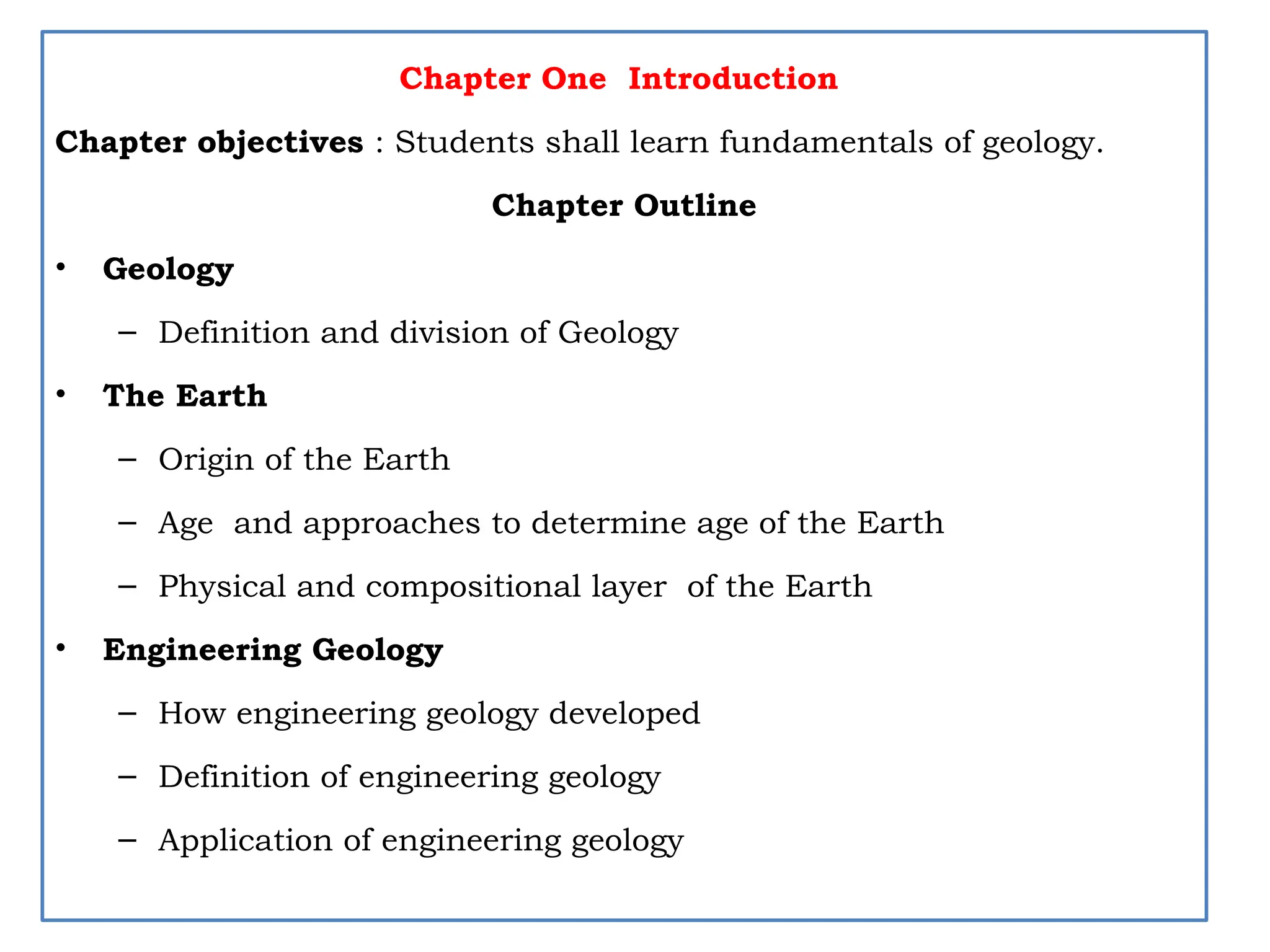
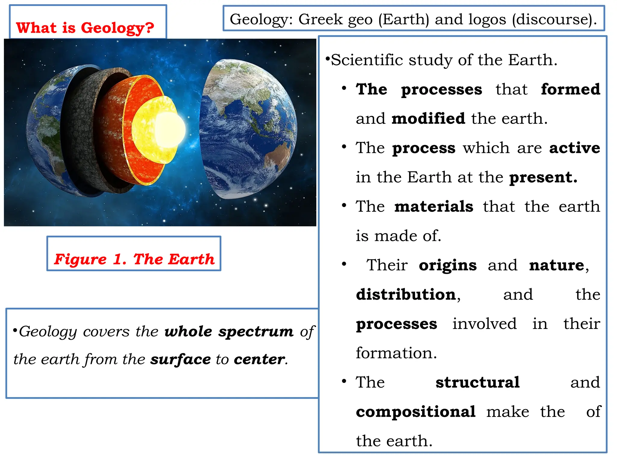
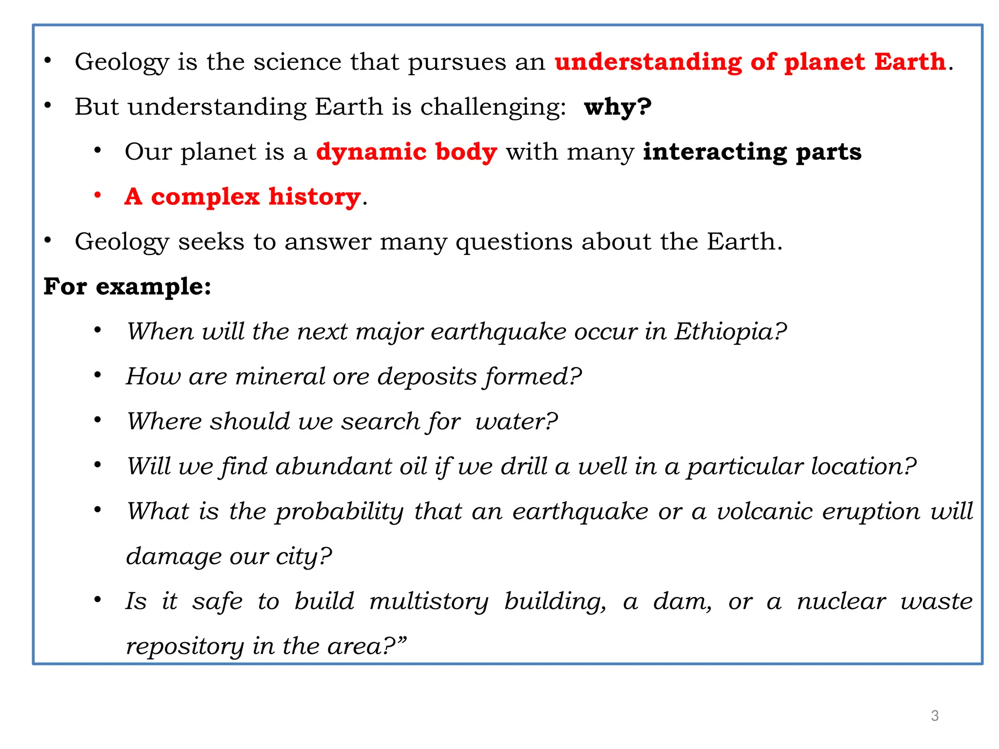
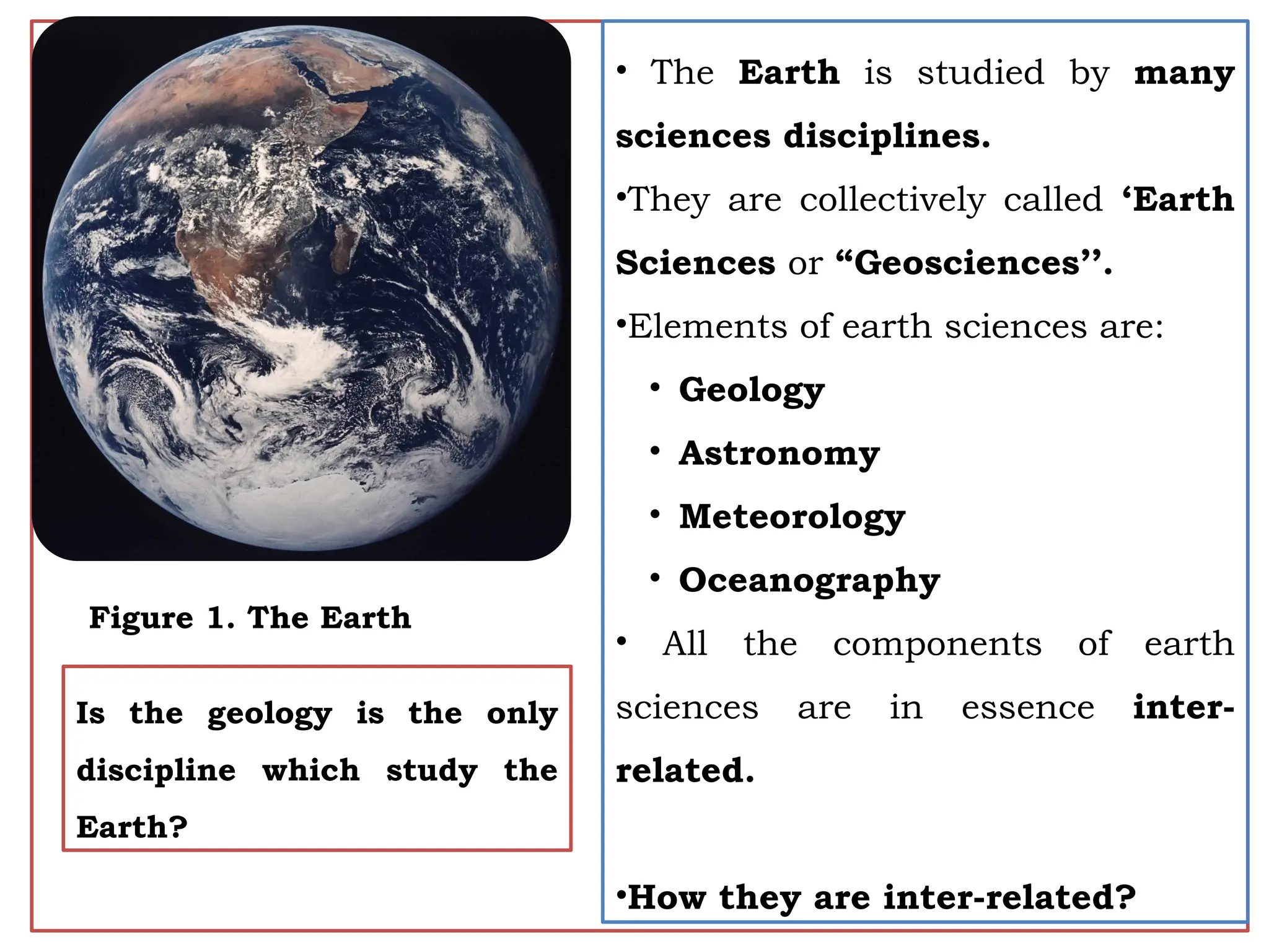
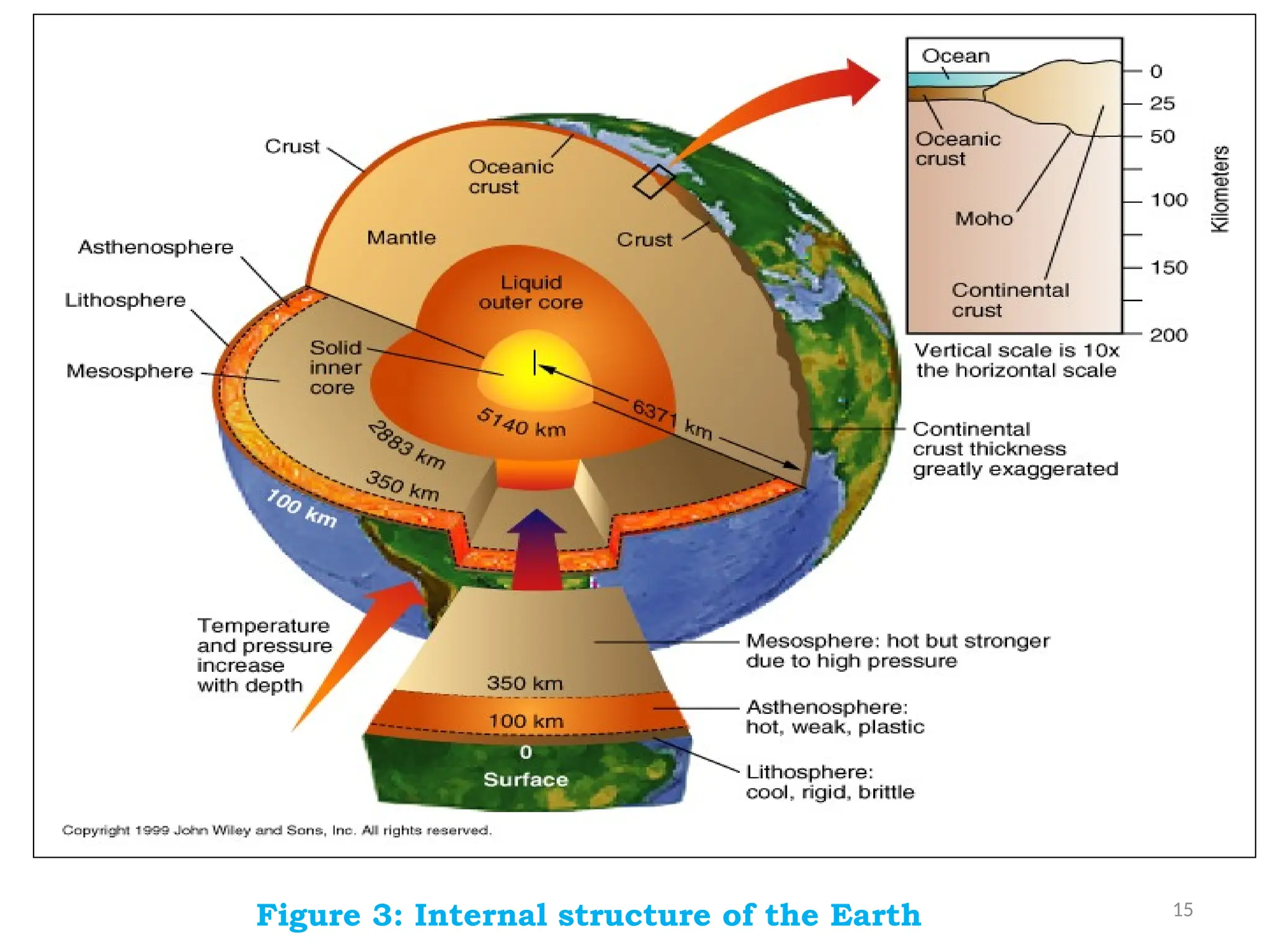
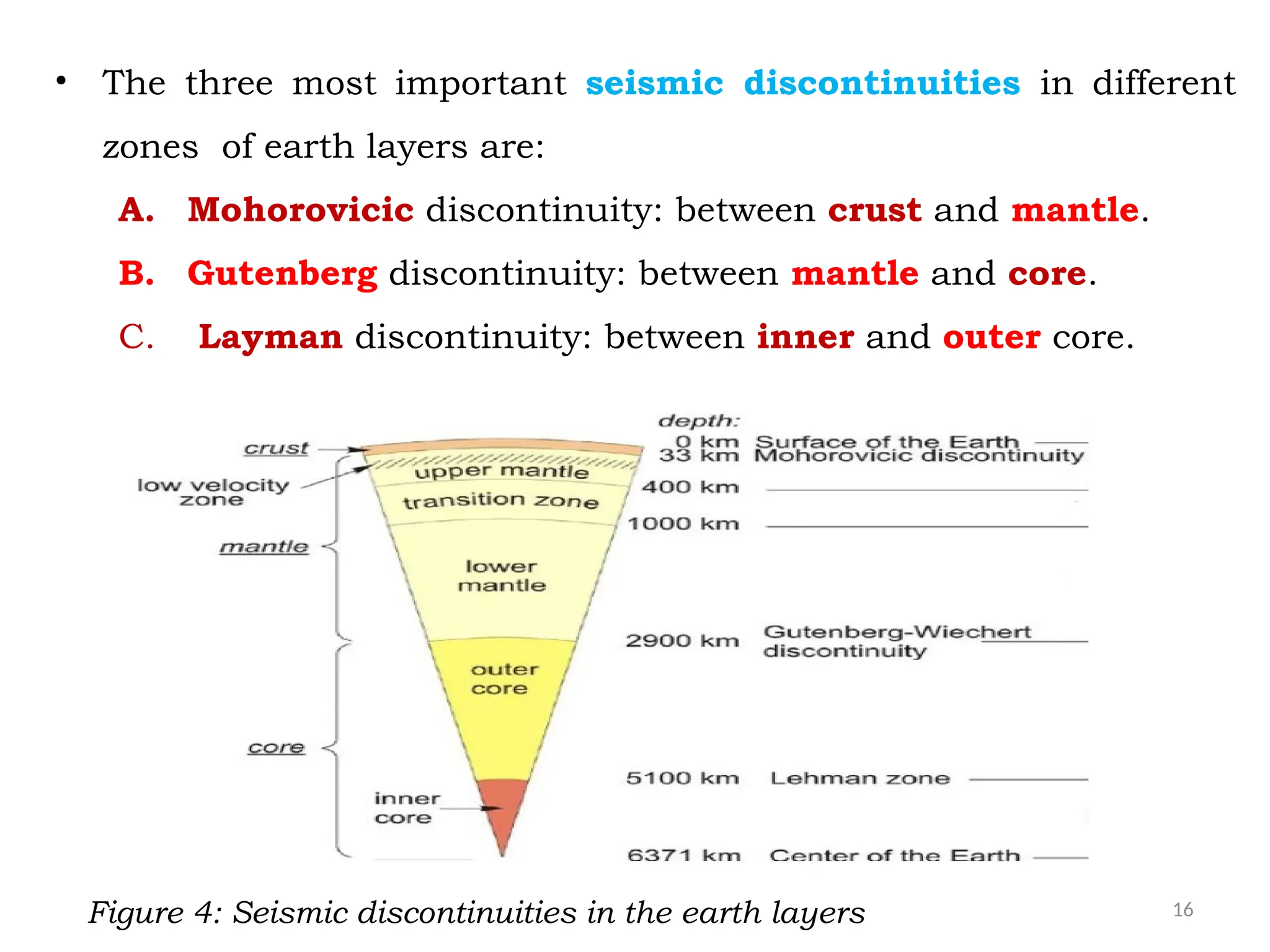
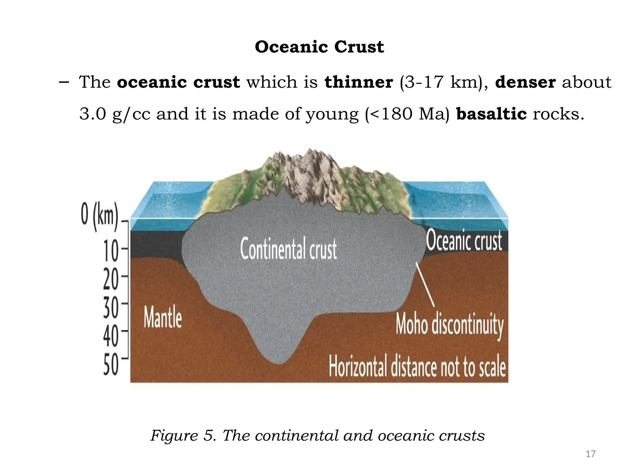
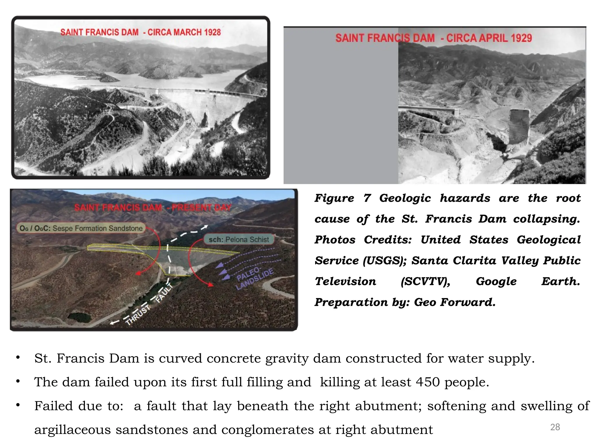
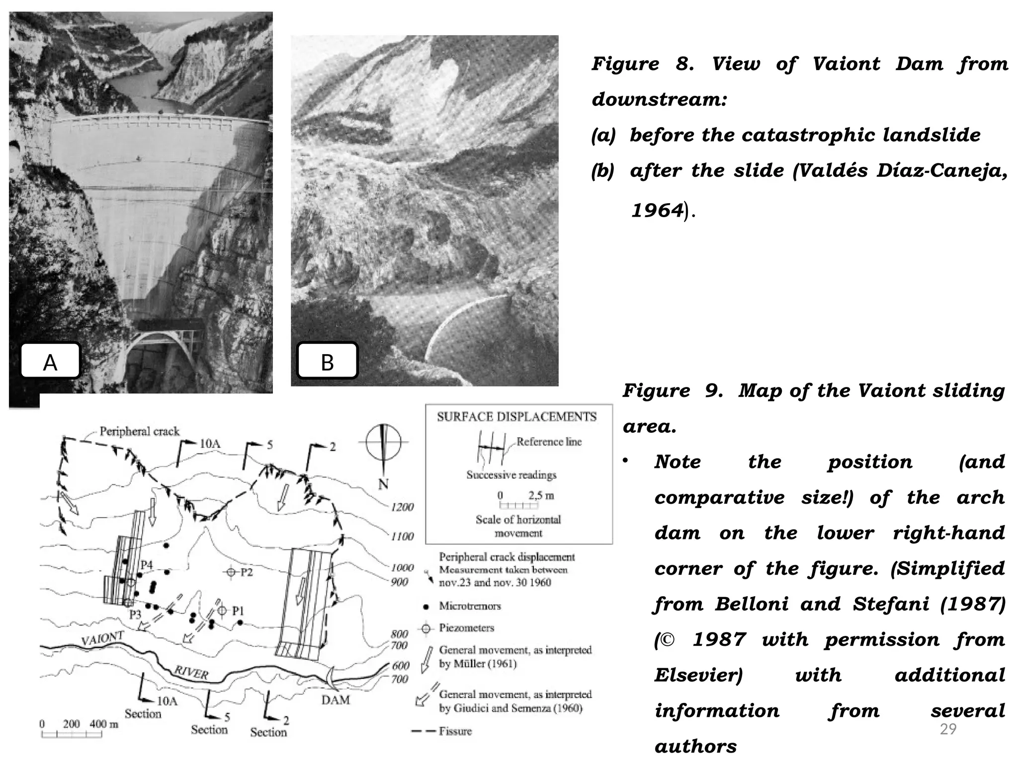
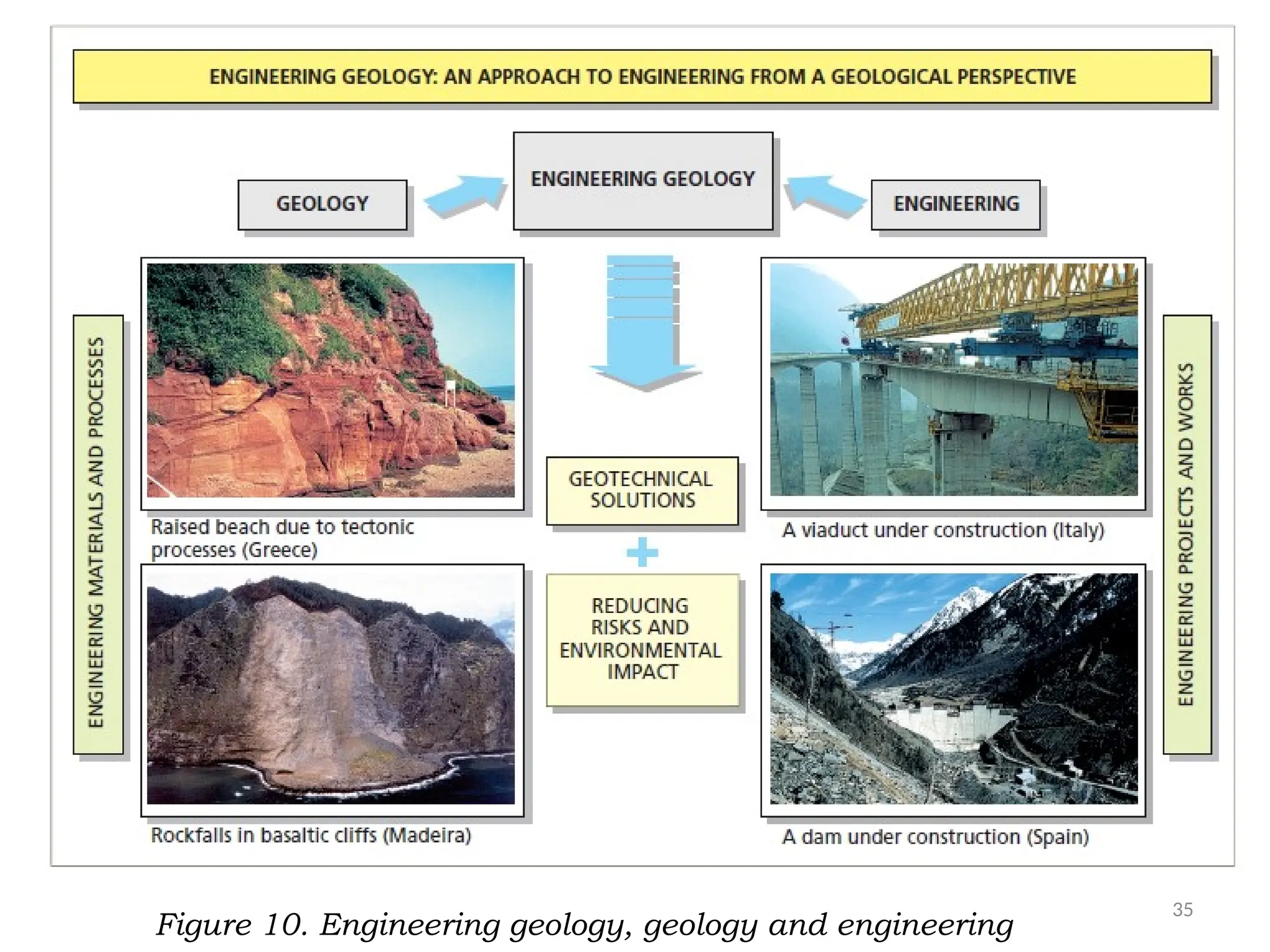
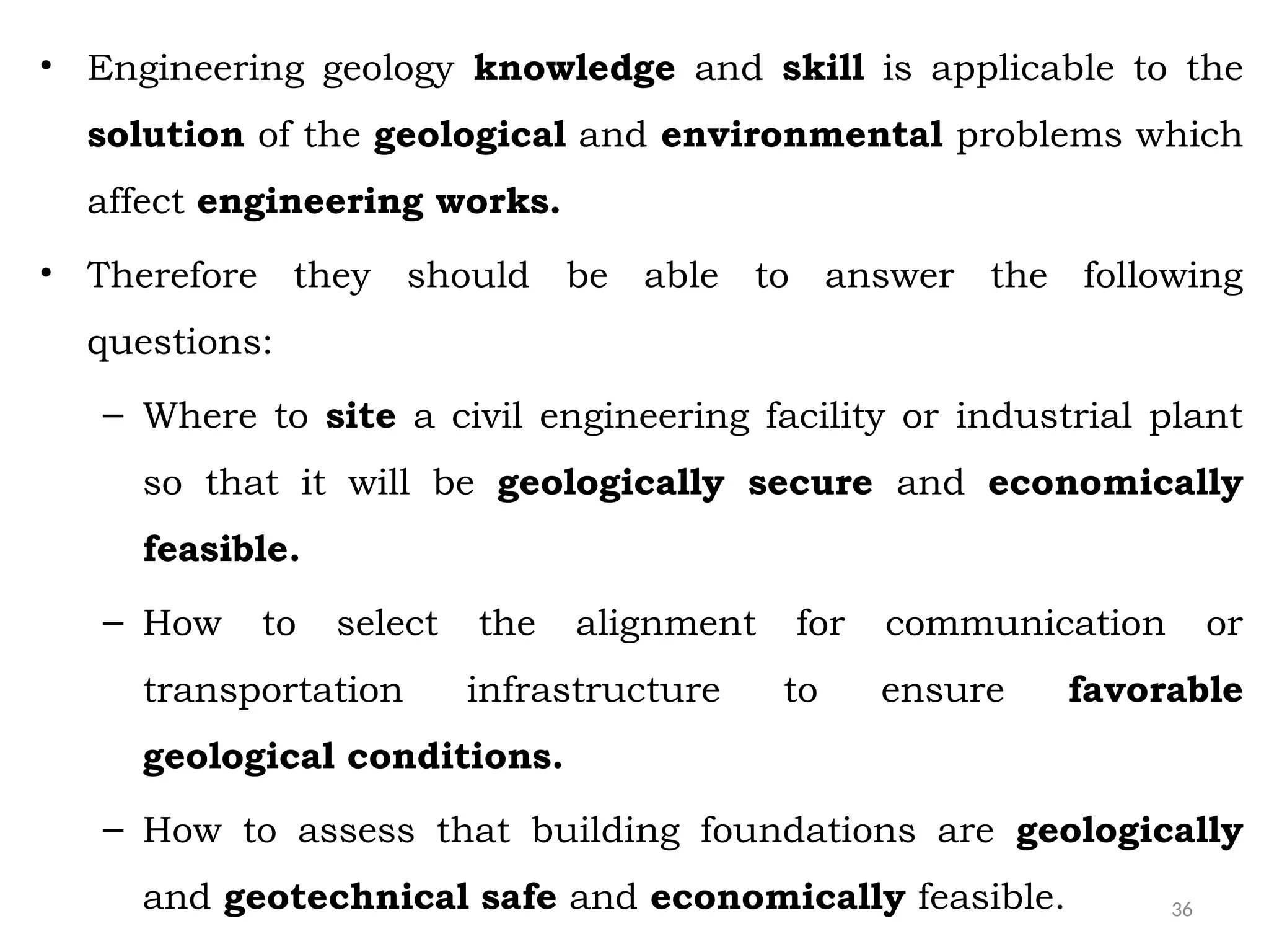
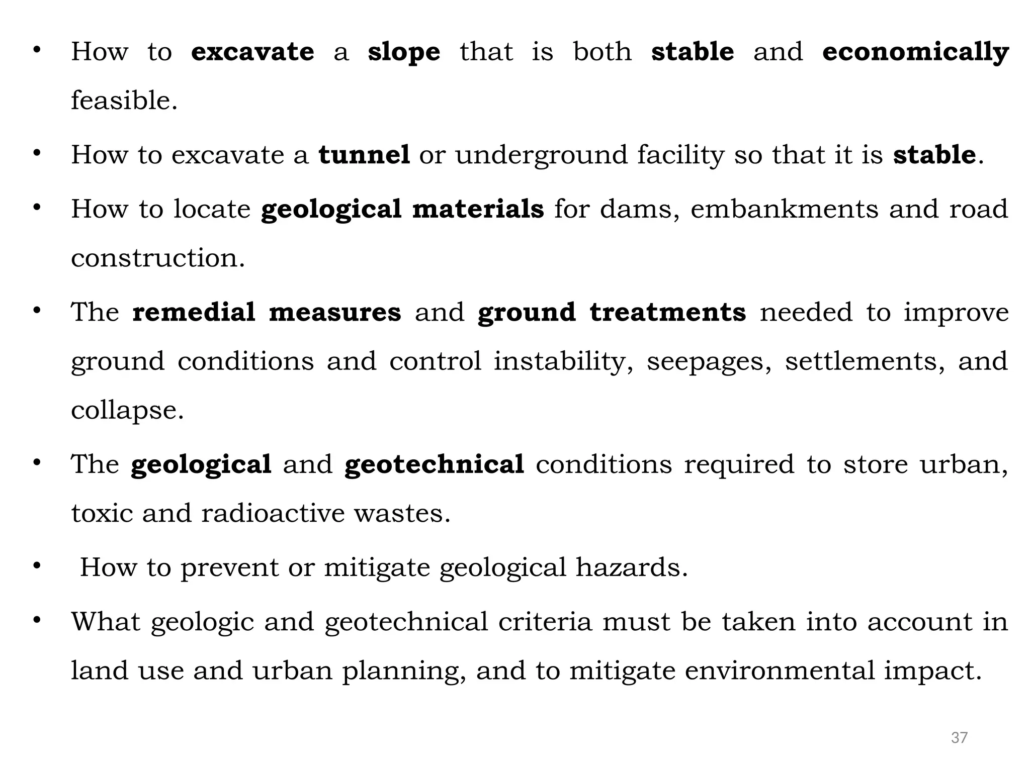
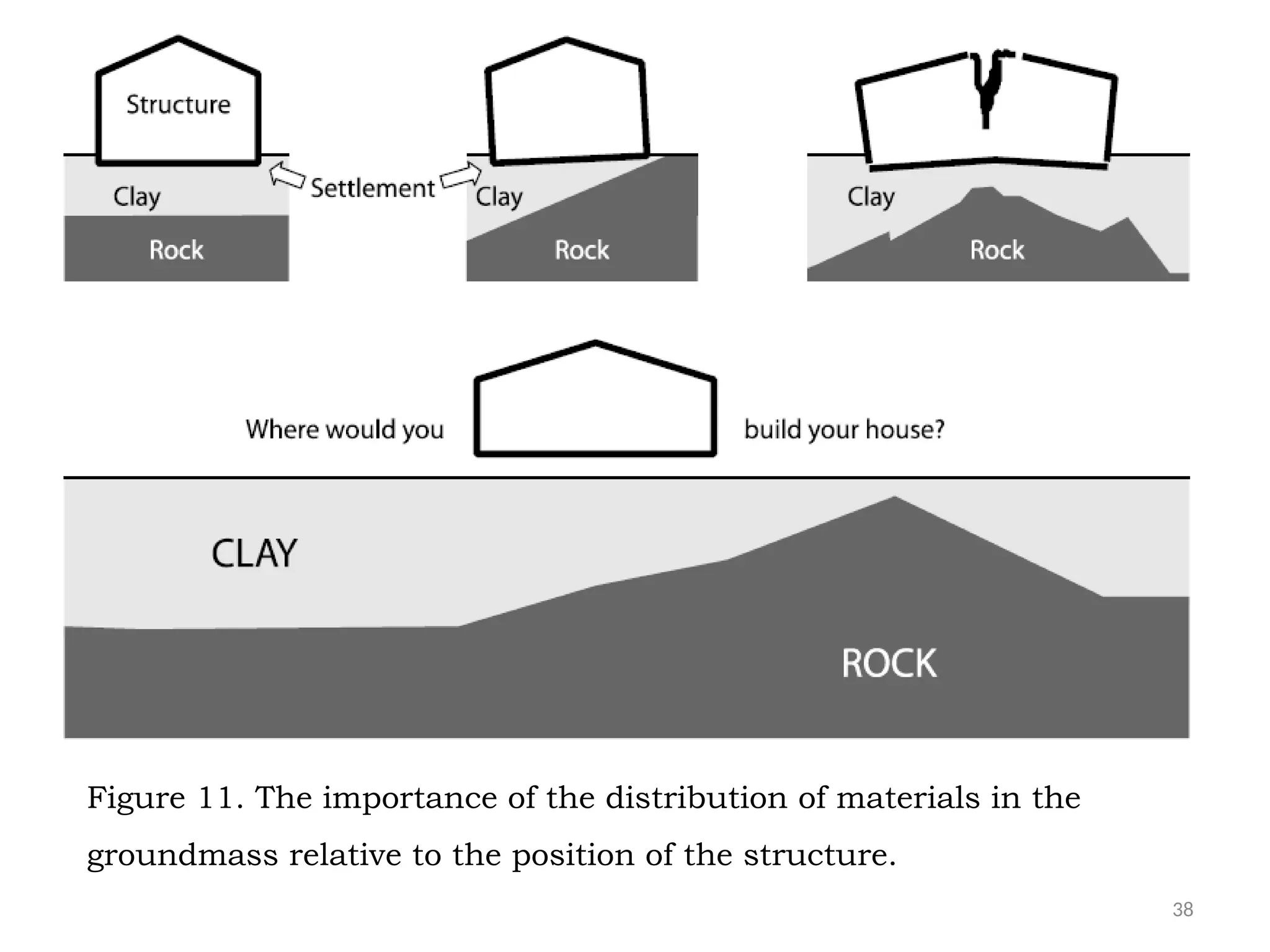
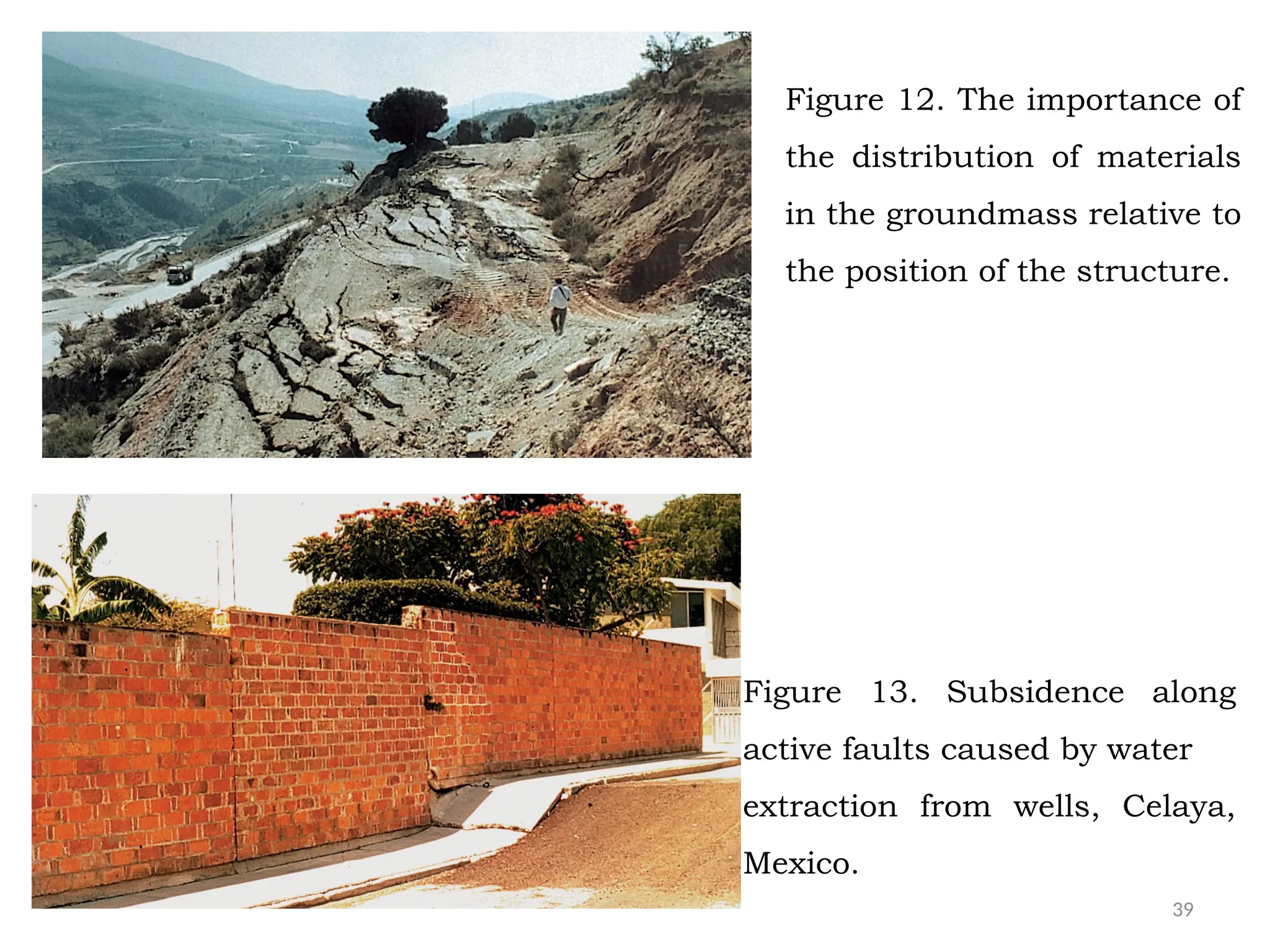
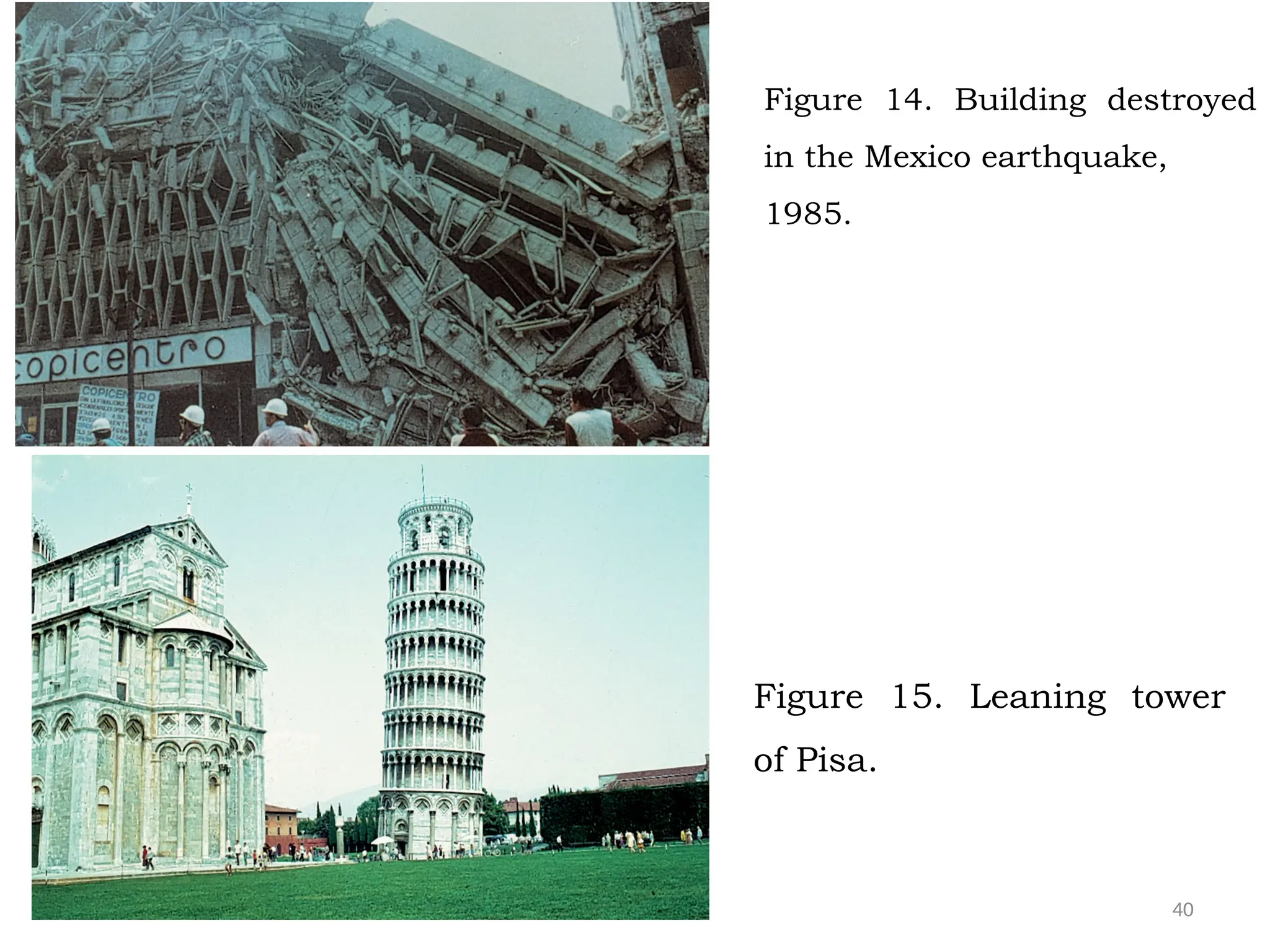
1
Chapter One Introduction
Chapter objectives : Students shall learn fundamentals of geology.
Chapter Outline
• Geology
– Definition and division of Geology
• The Earth
– Origin of the Earth
– Age and approaches to determine age of the Earth
– Physical and compositional layer of the Earth
• Engineering Geology
– How engineering geology developed
– Definition of engineering geology
– Application of engineering geology
2
•Scientific study of the Earth.
• The processes that formed
and modified the earth.
• The process which are active
in the Earth at the present.
• The materials that the earth
is made of.
• Their origins and nature,
distribution, and the
processes involved in their
formation.
• The structural and
compositional make the of
the earth.
What is Geology?
•Geology covers the whole spectrum of
the earth from the surface to center.
Geology: Greek geo (Earth) and logos (discourse).
Figure 1. The Earth
3
• Geology is the science that pursues an understanding of planet Earth.
• But understanding Earth is challenging: why?
• Our planet is a dynamic body with many interacting parts
• A complex history.
• Geology seeks to answer many questions about the Earth.
For example:
• When will the next major earthquake occur in Ethiopia?
• How are mineral ore deposits formed?
• Where should we search for water?
• Will we find abundant oil if we drill a well in a particular location?
• What is the probability that an earthquake or a volcanic eruption will
damage our city?
• Is it safe to build multistory building, a dam, or a nuclear waste
repository in the area?”
4
• The Earth is studied by many
sciences disciplines.
•They are collectively called ‘Earth
Sciences or “Geosciences’’.
•Elements of earth sciences are:
• Geology
• Astronomy
• Meteorology
• Oceanography
• All the components of earth
sciences are in essence inter-
related.
•How they are inter-related?
Is the geology is the only
discipline which study the
Earth?
Figure 1. The Earth
5
What are the major objectives of Geology
• Describe and interpret the physical features of the Earth explaining at
the same time their mode of formation.
• Decipher the history of the Earth’s evolution and of its past life from
the records preserved in the rocks.
• Study the materials that constitute it, the process that form and
change it so that the nature and essence of the whole Earth is
thoroughly understood.
• The earth processes that formed it and continuously modified it.
• Natural Earth processes that have an influence on human welfare.
• The natural resources which are of the economic importance.
– Locate those natural resources and their extent.
– Extract the natural resources and use them in sustainable manner.
6
What are sub-units of Geology?
• For practical purposes geology can be divided into basic/pure
and applied geology.
• Basic/pure Geology: deals with the origin of the Earth, the
processes which formed and change it, and the nature of
materials, which constitute it.
• Some of areas specialization of pure geology include
– Mineralogy and crystallography
– Petrology and Petrography
– Historical Geology (Paleontology and Stratigraphy)
– Physical Geology (Geomorphology)
– Structural Geology and Tectonics
7
What are sub-units of Geology?
• Applied Geology: uses the principles of geology and other
sciences
– To understand the nature of the earth, the earth processes
and the earth materials.
– To extract the natural resources of the earth.
• Some of most common applied field include:
– Economic Geology Environmental Geology
– Mining Geology Remote Sensing and GIS
– Petroleum Geology Geochemistry
– Hydrogeology Engineering Geology
– Geophysics Military Geology
– Medical Geology Forensic Geology
8
How the Universe is originated?
• The origin of the universe has been and still is under
considerable in debate.
• The Big-Bang theory is most popular theory which explain the
origin of the universe.
• It states that nearly 12 billion years ago, a fireball in which all
matter and energy was concentrated.
• Then, it was exploded (big bang) due to in which matter and
energy spread out in all directions.
• Then, material cooled and condensed into hydrogen clouds
which were latter changed into present day galaxies.
9
Origin of the Solar System
Nebular Theory
• Theory states that there existed a ancient, a rotating cloud of
dust and gas whose the shape and internal motion were
determined by gravitational and rotational forces.
• At some time, the gravitational force became the dominant
factor: contraction began and the rotation become speeded up
leading the cloud to flatten up into a disc.
• Matter began to drift into the center, accumulating into the
proto-sun.
• The proto-sun collapsed under its own gravitation becoming
dense and opaque as the material was compressed.
10
Origin of the Solar System
Nebular Theory
• Then, the sun began to shine with the initiation of the
thermonuclear reactions ( where molecules of hydrogen are
converted into helium atoms by emanating vast amount of
energy.
• The disc gradually cooled while it spun off and various solid
compounds condensed out of the gas forming the small grains.
• The grains gradually clumped together into small chunks
planetesimals, which finally coalesced by the action of gravity
forming the planets.
11
a). The Solar System was
originally a diffuse cloud of
dust and gas.
(b) This dust and gas
began to coalesce due to
gravity.
(c) The shrinking mass
began to rotate and formed
a disk.
(d) The mass broke up into a
discrete protosun orbited by large
protoplanets.
(e) The Sun heated until
fusion temperatures were
reached.
Figure 2. Formation of the Solar System.
12
Age of the Earth and how to determine its age
• The age of the Earth is considered to be 4.6-4.5 billion
years, equivalent to formation of our solar system.
How the age of the Earth is determined?
• The age of the Earth can be determined from dating
minerals, rocks and fossil evidence.
– The oldest terrestrial minerals (zircon, Australia) dated
so far are approximately 4.4 billion years.
– The oldest surviving rocks ( Acasta gneiss-northern
Canada) are on the Earth 4.0 billion years.
– The earliest fossil evidence for life (single celled
organisms) are of 3.5 billion years ago.
13
The internal Structure and composition of the Earth
• The Earth is composed of the materials that are arranged in a serious
of concentric layers of differing nature.
• However it is impossible to get a direct access to the interior of the
Earth.
• Therefore indirect methods have been used to study the interior
structure and compositions of the Earth.
• These are:
– Mathematical computation.
– Meteorites and Xenoliths.
• Samples brought to the surface from greater depths by volcanoes
or volcanic activity.
– Earthquake or seismic waves.
• Analysis of seismic waves that pass through Earth.
14
The internal structure/Anatomy of the Earth
• The Earth is divided into three big layers of different density,
composition, structure and thermal properties. These are:
Crust
– Thin outer part of the Earth with an average thickness of 35-
40 km.
– It is solid and composed of light density silicate rocks.
– The crust has different thickness, density, composition
and age at the continents and oceans.
– The continent crust is thicker (30-70 km), lighter 2.7g/cc
and it is made of older (3.8 billion years) granitic rocks.
15
Figure 3: Internal structure of the Earth
16
• The three most important seismic discontinuities in different
zones of earth layers are:
A. Mohorovicic discontinuity: between crust and mantle.
B. Gutenberg discontinuity: between mantle and core.
C. Layman discontinuity: between inner and outer core.
Figure 4: Seismic discontinuities in the earth layers
17
Oceanic Crust
– The oceanic crust which is thinner (3-17 km), denser about
3.0 g/cc and it is made of young (<180 Ma) basaltic rocks.
Figure 5. The continental and oceanic crusts
18
Mantle
– It extends from 40-2900 km depth.
– It comprises 85% of the Earth’s volume.
– It is a solid with some local fluid plumes at its upper part ( the
so called Low-velocity zone or Asthenosphere).
– The Asthenosphere is overlain by a solid and strong
Lithosphere.
– Mantle is composed of heavy density silicate minerals.
19
Core
– It extends from 2900 km to the center of the Earth.
– Core is liquid at its upper part and solid at its central part.
– Outer core: it is 2300 km thick
– Fe with Ni, S and O or Si with density of 11g/cc.
– Inner core: 1200 km thick
– Composed of solid Fe with Ni, S and O or Si with density
13.5g/cc.
– The core is hottest part of the Earth as the geothermal
gradient indicates.
20
Layers defined by physical properties
Lithosphere
Crust and uppermost mantle (about 100 km thick)
Cool, rigid and strong solid
 Crust + mantle
Asthenosphere
Beneath the lithosphere
Upper mantle, ductile but solid
To a depth of about 660 kilometers
Soft, weak layer that is easily deformed
21
Mesosphere (or lower mantle)
 660-2900 km
 More rigid and stronger layer than Asthenosphere because of
high pressure at this depth offset the effect of high temperature
Outer core
 Liquid layer
 2270 km (1410 miles) thick (2900-5200 Km)
 Convective flow of metallic iron within generates Earth’s
magnetic field
 The outer core is so hot around 3700ºC.
 The metal is always molten.
 Because the earth rotates, the outer core spins around the inner
core and that causes the earth's magnetism
22
Inner Core
 Sphere with a radius of 1216 km (754 miles)
 Behaves like a solid
 The inner core - the centre of earth.
 The inner core is: solid and thick
 Very high temperatures around 4300ºC.
 Very high pressure, it cannot melt.
 5200-6400 km
 Inner core remains solid because the rate of pressure is more
than the rate of temperature. It off set the effect of temperature
and affect the melting point of the Fe and Ni alloys.
23
Figure 6. Layers of the Earth.
24
Composition of the Earth
• The elemental composition
of the Earth is simple.
• More than 99% of the
whole Earth is made up of
only 8 elements (Fe, O, Si,
Mg, Ni, S, Ca, Al).
• Similarly more than 99% of
bulk composition of the
earth is made of 8
elements ( O, Si, Al, Fe,
Mg, Ca, K, Na).
25
Exercises
• Define geology and its sub-units.
• Explain the contribution of Geology to the understanding of the nature
as whole.
• Explain the nebular hypothesis and how the earth is created from
nebular matter.
• Draw simple sketch of the major layers of the earth and explain the
relationships among the different layers of the Earth.
• Why are the terrestrial planets are denser than jovial planets?
• Write the brief account of the composition, internal structure and
physical properties of the Earth.
• Explain the methods that used understand the internal structure of
the Earth.
• What are the main difference between Lithosphere and Asthenosphere.
Development of engineering geology
• Catastrophic failure of several large engineering works. For example
– Failure of dams for geological reasons
• In 1928 San Francisco Dam
• In 1959 Malpasset Dam
• In 1963 Vajont Dam
– In 1912 collapse of Slope on the Swedish railway
– 20th
century landslides during Panama canal
• Development of large scale civil engineering projects
• Urban growth
• Development of other sciences: Soil and rock mechanics
27
• When the St. Francis Dam in southern California failed in 1928 with
a loss of many lives and damages in millions of dollars, the civil
engineering profession awoke to the idea that the careful design
of a structure itself is not all that is required for its safety.
• In fact it is equally important to investigate and understand the
nature and behavior of the foundation soil or rocks.
• After the failure of St. Francis Dam, the need of exploration of
foundation condition with proper interpretation of the results was
understood by all.
• Engineering geology, a relatively young field, emerged through
recognition of the need for geologic input into engineering
projects.
28
Figure 7 Geologic hazards are the root
cause of the St. Francis Dam collapsing.
Photos Credits: United States Geological
Service (USGS); Santa Clarita Valley Public
Television (SCVTV), Google Earth.
Preparation by: Geo Forward.
• St. Francis Dam is curved concrete gravity dam constructed for water supply.
• The dam failed upon its first full filling and killing at least 450 people.
• Failed due to: a fault that lay beneath the right abutment; softening and swelling of
argillaceous sandstones and conglomerates at right abutment
29
Figure 8. View of Vaiont Dam from
downstream:
(a) before the catastrophic landslide
(b) after the slide (Valdés Díaz-Caneja,
1964).
Figure 9. Map of the Vaiont sliding
area.
• Note the position (and
comparative size!) of the arch
dam on the lower right-hand
corner of the figure. (Simplified
from Belloni and Stefani (1987)
(© 1987 with permission from
Elsevier) with additional
information from several
authors
A B
30
• By the 1940s, a trend for civil engineers to employ geologists in an advisory
capacity have started.
• Eventually engineering geology became sufficiently developed for the subject to
form part of university curricula.
• Thus, in Imperial College, London, engineering geology was taught at
postgraduate level to both geologists and engineers as early as 1957 under the
guidance of John Knill.
• This expanded in 1963 to become the Association of Engineering Geologists
(AEG), covering all the United States and now with an international
membership.
• In 1967, the International Association of Engineering Geology (IAEG) was
formed.
• Reputable journals for engineering geology, Quarterly Journal of Engineering
Geology and Hydrogeology have also developed, such as “Engineering Geology”,
published by Elsevier.
31
• Behind every discipline there must be a basic philosophy or a way in
which that discipline approaches its problems.
• The philosophy of engineering geology is based on three simple
premises. These are:
1. All engineering works are built in or on the ground.
2. The ground will always, in some manner, react to the construction of the
engineering work.
3. The reaction of the ground (its “engineering behavior”) to the particular
engineering work must be accommodated by that work.
What is Engineering Geology
• The application of geology to civil engineering projects is known as
‘engineering geology’.
• It is concerned with those geological factors that influence the location,
design, construction and maintenance of engineering works.
32
• The American Geological Institute defined engineering
geology as 'the application of the geological sciences to
engineering practice for the purpose of assuring that the
geological factors affecting the location, design,
construction, operation and maintenance of engineering
works are recognized and adequately provided for’.
• W. R. Judd in the McGraw-Hill Encyclopaedia of Science
and Technology as 'the application of education and
experience in geology and other geosciences to solve
geological problems posed by civil engineering structures'.
33
Definitions given by Association of Engineering Geologists (AEG)
• “Engineering Geology is defined by the Association of Engineering
Geologists (AEG): as the discipline of applying geologic data,
techniques, and principles to the study of both;
a) naturally occurring rock and soil materials, and surface and sub-
surface fluids and
b) the interaction of introduced materials and processes with the
geologic environment,
 so that geologic factors affecting the planning, design,
construction, operation and maintenance of engineering
structures (fixed works) and the development, protection
and remediation of ground-water resources are adequately
recognized, interpreted and presented for use in
engineering and related practice.”
34
Definition given by: Engineering Geology as The International
Association of Engineering Geologists (IAEG)
• The science devoted to the investigation, study and solution of
the engineering and environmental problems which may arise
as the result of the interaction between geology and the works
and activities of man as well as to the prediction and of the
development of measures for prevention or remediation of
geological hazards.
35
Figure 10. Engineering geology, geology and engineering
36
• Engineering geology knowledge and skill is applicable to the
solution of the geological and environmental problems which
affect engineering works.
• Therefore they should be able to answer the following
questions:
– Where to site a civil engineering facility or industrial plant
so that it will be geologically secure and economically
feasible.
– How to select the alignment for communication or
transportation infrastructure to ensure favorable
geological conditions.
– How to assess that building foundations are geologically
and geotechnical safe and economically feasible.
37
• How to excavate a slope that is both stable and economically
feasible.
• How to excavate a tunnel or underground facility so that it is stable.
• How to locate geological materials for dams, embankments and road
construction.
• The remedial measures and ground treatments needed to improve
ground conditions and control instability, seepages, settlements, and
collapse.
• The geological and geotechnical conditions required to store urban,
toxic and radioactive wastes.
• How to prevent or mitigate geological hazards.
• What geologic and geotechnical criteria must be taken into account in
land use and urban planning, and to mitigate environmental impact.
38
Figure 11. The importance of the distribution of materials in the
groundmass relative to the position of the structure.
39
Figure 12. The importance of
the distribution of materials
in the groundmass relative to
the position of the structure.
Figure 13. Subsidence along
active faults caused by water
extraction from wells, Celaya,
Mexico.
40
Figure 14. Building destroyed
in the Mexico earthquake,
1985.
Figure 15. Leaning tower
of Pisa.
41
• The importance of engineering geology is particularly important
in two main fields of activity.
– The first is engineering projects and related works where the
ground constitutes the foundation, excavation, storage or
construction material.
– Included in this field are the main types of infrastructure
projects:
• Buildings
• Hydraulic or maritime works
• Industrial plants, mining installations, power
stations, etc.
– The role of engineering geology in these projects is
fundamental to ensuring safety and economic viability.
Significant of Engineering Geology
42
• The importance of engineering geology is particularly important
in two main fields of activity.
– The second field is the prevention, mitigation and control
of geological hazards and risks, and the management of
environmental impact of public works and industrial,
mining or urban activities.
• Both of these fields are of great importance to a country’s gross
national product as they are directly related to the
infrastructure, construction, mining and building sectors.
• However, the impacts of geo-environmental hazards on society
and the environment can be countless if no preventive or control
measures are taken.
Significant of Engineering Geology
43
Figure 16. Silting of
riverbed to above road
level, requiring excavation
to an artificial channel,
northwest Argentina.
Figure 17. Building destroyed
in the Mexico earthquake,
1985.

Chapter One (2).pptx this is geology power point to know formation of rocks to prevent fall of construction

  • 1.
    1 Chapter One Introduction Chapterobjectives : Students shall learn fundamentals of geology. Chapter Outline • Geology – Definition and division of Geology • The Earth – Origin of the Earth – Age and approaches to determine age of the Earth – Physical and compositional layer of the Earth • Engineering Geology – How engineering geology developed – Definition of engineering geology – Application of engineering geology
  • 2.
    2 •Scientific study ofthe Earth. • The processes that formed and modified the earth. • The process which are active in the Earth at the present. • The materials that the earth is made of. • Their origins and nature, distribution, and the processes involved in their formation. • The structural and compositional make the of the earth. What is Geology? •Geology covers the whole spectrum of the earth from the surface to center. Geology: Greek geo (Earth) and logos (discourse). Figure 1. The Earth
  • 3.
    3 • Geology isthe science that pursues an understanding of planet Earth. • But understanding Earth is challenging: why? • Our planet is a dynamic body with many interacting parts • A complex history. • Geology seeks to answer many questions about the Earth. For example: • When will the next major earthquake occur in Ethiopia? • How are mineral ore deposits formed? • Where should we search for water? • Will we find abundant oil if we drill a well in a particular location? • What is the probability that an earthquake or a volcanic eruption will damage our city? • Is it safe to build multistory building, a dam, or a nuclear waste repository in the area?”
  • 4.
    4 • The Earthis studied by many sciences disciplines. •They are collectively called ‘Earth Sciences or “Geosciences’’. •Elements of earth sciences are: • Geology • Astronomy • Meteorology • Oceanography • All the components of earth sciences are in essence inter- related. •How they are inter-related? Is the geology is the only discipline which study the Earth? Figure 1. The Earth
  • 5.
    5 What are themajor objectives of Geology • Describe and interpret the physical features of the Earth explaining at the same time their mode of formation. • Decipher the history of the Earth’s evolution and of its past life from the records preserved in the rocks. • Study the materials that constitute it, the process that form and change it so that the nature and essence of the whole Earth is thoroughly understood. • The earth processes that formed it and continuously modified it. • Natural Earth processes that have an influence on human welfare. • The natural resources which are of the economic importance. – Locate those natural resources and their extent. – Extract the natural resources and use them in sustainable manner.
  • 6.
    6 What are sub-unitsof Geology? • For practical purposes geology can be divided into basic/pure and applied geology. • Basic/pure Geology: deals with the origin of the Earth, the processes which formed and change it, and the nature of materials, which constitute it. • Some of areas specialization of pure geology include – Mineralogy and crystallography – Petrology and Petrography – Historical Geology (Paleontology and Stratigraphy) – Physical Geology (Geomorphology) – Structural Geology and Tectonics
  • 7.
    7 What are sub-unitsof Geology? • Applied Geology: uses the principles of geology and other sciences – To understand the nature of the earth, the earth processes and the earth materials. – To extract the natural resources of the earth. • Some of most common applied field include: – Economic Geology Environmental Geology – Mining Geology Remote Sensing and GIS – Petroleum Geology Geochemistry – Hydrogeology Engineering Geology – Geophysics Military Geology – Medical Geology Forensic Geology
  • 8.
    8 How the Universeis originated? • The origin of the universe has been and still is under considerable in debate. • The Big-Bang theory is most popular theory which explain the origin of the universe. • It states that nearly 12 billion years ago, a fireball in which all matter and energy was concentrated. • Then, it was exploded (big bang) due to in which matter and energy spread out in all directions. • Then, material cooled and condensed into hydrogen clouds which were latter changed into present day galaxies.
  • 9.
    9 Origin of theSolar System Nebular Theory • Theory states that there existed a ancient, a rotating cloud of dust and gas whose the shape and internal motion were determined by gravitational and rotational forces. • At some time, the gravitational force became the dominant factor: contraction began and the rotation become speeded up leading the cloud to flatten up into a disc. • Matter began to drift into the center, accumulating into the proto-sun. • The proto-sun collapsed under its own gravitation becoming dense and opaque as the material was compressed.
  • 10.
    10 Origin of theSolar System Nebular Theory • Then, the sun began to shine with the initiation of the thermonuclear reactions ( where molecules of hydrogen are converted into helium atoms by emanating vast amount of energy. • The disc gradually cooled while it spun off and various solid compounds condensed out of the gas forming the small grains. • The grains gradually clumped together into small chunks planetesimals, which finally coalesced by the action of gravity forming the planets.
  • 11.
    11 a). The SolarSystem was originally a diffuse cloud of dust and gas. (b) This dust and gas began to coalesce due to gravity. (c) The shrinking mass began to rotate and formed a disk. (d) The mass broke up into a discrete protosun orbited by large protoplanets. (e) The Sun heated until fusion temperatures were reached. Figure 2. Formation of the Solar System.
  • 12.
    12 Age of theEarth and how to determine its age • The age of the Earth is considered to be 4.6-4.5 billion years, equivalent to formation of our solar system. How the age of the Earth is determined? • The age of the Earth can be determined from dating minerals, rocks and fossil evidence. – The oldest terrestrial minerals (zircon, Australia) dated so far are approximately 4.4 billion years. – The oldest surviving rocks ( Acasta gneiss-northern Canada) are on the Earth 4.0 billion years. – The earliest fossil evidence for life (single celled organisms) are of 3.5 billion years ago.
  • 13.
    13 The internal Structureand composition of the Earth • The Earth is composed of the materials that are arranged in a serious of concentric layers of differing nature. • However it is impossible to get a direct access to the interior of the Earth. • Therefore indirect methods have been used to study the interior structure and compositions of the Earth. • These are: – Mathematical computation. – Meteorites and Xenoliths. • Samples brought to the surface from greater depths by volcanoes or volcanic activity. – Earthquake or seismic waves. • Analysis of seismic waves that pass through Earth.
  • 14.
    14 The internal structure/Anatomyof the Earth • The Earth is divided into three big layers of different density, composition, structure and thermal properties. These are: Crust – Thin outer part of the Earth with an average thickness of 35- 40 km. – It is solid and composed of light density silicate rocks. – The crust has different thickness, density, composition and age at the continents and oceans. – The continent crust is thicker (30-70 km), lighter 2.7g/cc and it is made of older (3.8 billion years) granitic rocks.
  • 15.
    15 Figure 3: Internalstructure of the Earth
  • 16.
    16 • The threemost important seismic discontinuities in different zones of earth layers are: A. Mohorovicic discontinuity: between crust and mantle. B. Gutenberg discontinuity: between mantle and core. C. Layman discontinuity: between inner and outer core. Figure 4: Seismic discontinuities in the earth layers
  • 17.
    17 Oceanic Crust – Theoceanic crust which is thinner (3-17 km), denser about 3.0 g/cc and it is made of young (<180 Ma) basaltic rocks. Figure 5. The continental and oceanic crusts
  • 18.
    18 Mantle – It extendsfrom 40-2900 km depth. – It comprises 85% of the Earth’s volume. – It is a solid with some local fluid plumes at its upper part ( the so called Low-velocity zone or Asthenosphere). – The Asthenosphere is overlain by a solid and strong Lithosphere. – Mantle is composed of heavy density silicate minerals.
  • 19.
    19 Core – It extendsfrom 2900 km to the center of the Earth. – Core is liquid at its upper part and solid at its central part. – Outer core: it is 2300 km thick – Fe with Ni, S and O or Si with density of 11g/cc. – Inner core: 1200 km thick – Composed of solid Fe with Ni, S and O or Si with density 13.5g/cc. – The core is hottest part of the Earth as the geothermal gradient indicates.
  • 20.
    20 Layers defined byphysical properties Lithosphere Crust and uppermost mantle (about 100 km thick) Cool, rigid and strong solid  Crust + mantle Asthenosphere Beneath the lithosphere Upper mantle, ductile but solid To a depth of about 660 kilometers Soft, weak layer that is easily deformed
  • 21.
    21 Mesosphere (or lowermantle)  660-2900 km  More rigid and stronger layer than Asthenosphere because of high pressure at this depth offset the effect of high temperature Outer core  Liquid layer  2270 km (1410 miles) thick (2900-5200 Km)  Convective flow of metallic iron within generates Earth’s magnetic field  The outer core is so hot around 3700ºC.  The metal is always molten.  Because the earth rotates, the outer core spins around the inner core and that causes the earth's magnetism
  • 22.
    22 Inner Core  Spherewith a radius of 1216 km (754 miles)  Behaves like a solid  The inner core - the centre of earth.  The inner core is: solid and thick  Very high temperatures around 4300ºC.  Very high pressure, it cannot melt.  5200-6400 km  Inner core remains solid because the rate of pressure is more than the rate of temperature. It off set the effect of temperature and affect the melting point of the Fe and Ni alloys.
  • 23.
    23 Figure 6. Layersof the Earth.
  • 24.
    24 Composition of theEarth • The elemental composition of the Earth is simple. • More than 99% of the whole Earth is made up of only 8 elements (Fe, O, Si, Mg, Ni, S, Ca, Al). • Similarly more than 99% of bulk composition of the earth is made of 8 elements ( O, Si, Al, Fe, Mg, Ca, K, Na).
  • 25.
    25 Exercises • Define geologyand its sub-units. • Explain the contribution of Geology to the understanding of the nature as whole. • Explain the nebular hypothesis and how the earth is created from nebular matter. • Draw simple sketch of the major layers of the earth and explain the relationships among the different layers of the Earth. • Why are the terrestrial planets are denser than jovial planets? • Write the brief account of the composition, internal structure and physical properties of the Earth. • Explain the methods that used understand the internal structure of the Earth. • What are the main difference between Lithosphere and Asthenosphere.
  • 26.
    Development of engineeringgeology • Catastrophic failure of several large engineering works. For example – Failure of dams for geological reasons • In 1928 San Francisco Dam • In 1959 Malpasset Dam • In 1963 Vajont Dam – In 1912 collapse of Slope on the Swedish railway – 20th century landslides during Panama canal • Development of large scale civil engineering projects • Urban growth • Development of other sciences: Soil and rock mechanics
  • 27.
    27 • When theSt. Francis Dam in southern California failed in 1928 with a loss of many lives and damages in millions of dollars, the civil engineering profession awoke to the idea that the careful design of a structure itself is not all that is required for its safety. • In fact it is equally important to investigate and understand the nature and behavior of the foundation soil or rocks. • After the failure of St. Francis Dam, the need of exploration of foundation condition with proper interpretation of the results was understood by all. • Engineering geology, a relatively young field, emerged through recognition of the need for geologic input into engineering projects.
  • 28.
    28 Figure 7 Geologichazards are the root cause of the St. Francis Dam collapsing. Photos Credits: United States Geological Service (USGS); Santa Clarita Valley Public Television (SCVTV), Google Earth. Preparation by: Geo Forward. • St. Francis Dam is curved concrete gravity dam constructed for water supply. • The dam failed upon its first full filling and killing at least 450 people. • Failed due to: a fault that lay beneath the right abutment; softening and swelling of argillaceous sandstones and conglomerates at right abutment
  • 29.
    29 Figure 8. Viewof Vaiont Dam from downstream: (a) before the catastrophic landslide (b) after the slide (Valdés Díaz-Caneja, 1964). Figure 9. Map of the Vaiont sliding area. • Note the position (and comparative size!) of the arch dam on the lower right-hand corner of the figure. (Simplified from Belloni and Stefani (1987) (© 1987 with permission from Elsevier) with additional information from several authors A B
  • 30.
    30 • By the1940s, a trend for civil engineers to employ geologists in an advisory capacity have started. • Eventually engineering geology became sufficiently developed for the subject to form part of university curricula. • Thus, in Imperial College, London, engineering geology was taught at postgraduate level to both geologists and engineers as early as 1957 under the guidance of John Knill. • This expanded in 1963 to become the Association of Engineering Geologists (AEG), covering all the United States and now with an international membership. • In 1967, the International Association of Engineering Geology (IAEG) was formed. • Reputable journals for engineering geology, Quarterly Journal of Engineering Geology and Hydrogeology have also developed, such as “Engineering Geology”, published by Elsevier.
  • 31.
    31 • Behind everydiscipline there must be a basic philosophy or a way in which that discipline approaches its problems. • The philosophy of engineering geology is based on three simple premises. These are: 1. All engineering works are built in or on the ground. 2. The ground will always, in some manner, react to the construction of the engineering work. 3. The reaction of the ground (its “engineering behavior”) to the particular engineering work must be accommodated by that work. What is Engineering Geology • The application of geology to civil engineering projects is known as ‘engineering geology’. • It is concerned with those geological factors that influence the location, design, construction and maintenance of engineering works.
  • 32.
    32 • The AmericanGeological Institute defined engineering geology as 'the application of the geological sciences to engineering practice for the purpose of assuring that the geological factors affecting the location, design, construction, operation and maintenance of engineering works are recognized and adequately provided for’. • W. R. Judd in the McGraw-Hill Encyclopaedia of Science and Technology as 'the application of education and experience in geology and other geosciences to solve geological problems posed by civil engineering structures'.
  • 33.
    33 Definitions given byAssociation of Engineering Geologists (AEG) • “Engineering Geology is defined by the Association of Engineering Geologists (AEG): as the discipline of applying geologic data, techniques, and principles to the study of both; a) naturally occurring rock and soil materials, and surface and sub- surface fluids and b) the interaction of introduced materials and processes with the geologic environment,  so that geologic factors affecting the planning, design, construction, operation and maintenance of engineering structures (fixed works) and the development, protection and remediation of ground-water resources are adequately recognized, interpreted and presented for use in engineering and related practice.”
  • 34.
    34 Definition given by:Engineering Geology as The International Association of Engineering Geologists (IAEG) • The science devoted to the investigation, study and solution of the engineering and environmental problems which may arise as the result of the interaction between geology and the works and activities of man as well as to the prediction and of the development of measures for prevention or remediation of geological hazards.
  • 35.
    35 Figure 10. Engineeringgeology, geology and engineering
  • 36.
    36 • Engineering geologyknowledge and skill is applicable to the solution of the geological and environmental problems which affect engineering works. • Therefore they should be able to answer the following questions: – Where to site a civil engineering facility or industrial plant so that it will be geologically secure and economically feasible. – How to select the alignment for communication or transportation infrastructure to ensure favorable geological conditions. – How to assess that building foundations are geologically and geotechnical safe and economically feasible.
  • 37.
    37 • How toexcavate a slope that is both stable and economically feasible. • How to excavate a tunnel or underground facility so that it is stable. • How to locate geological materials for dams, embankments and road construction. • The remedial measures and ground treatments needed to improve ground conditions and control instability, seepages, settlements, and collapse. • The geological and geotechnical conditions required to store urban, toxic and radioactive wastes. • How to prevent or mitigate geological hazards. • What geologic and geotechnical criteria must be taken into account in land use and urban planning, and to mitigate environmental impact.
  • 38.
    38 Figure 11. Theimportance of the distribution of materials in the groundmass relative to the position of the structure.
  • 39.
    39 Figure 12. Theimportance of the distribution of materials in the groundmass relative to the position of the structure. Figure 13. Subsidence along active faults caused by water extraction from wells, Celaya, Mexico.
  • 40.
    40 Figure 14. Buildingdestroyed in the Mexico earthquake, 1985. Figure 15. Leaning tower of Pisa.
  • 41.
    41 • The importanceof engineering geology is particularly important in two main fields of activity. – The first is engineering projects and related works where the ground constitutes the foundation, excavation, storage or construction material. – Included in this field are the main types of infrastructure projects: • Buildings • Hydraulic or maritime works • Industrial plants, mining installations, power stations, etc. – The role of engineering geology in these projects is fundamental to ensuring safety and economic viability. Significant of Engineering Geology
  • 42.
    42 • The importanceof engineering geology is particularly important in two main fields of activity. – The second field is the prevention, mitigation and control of geological hazards and risks, and the management of environmental impact of public works and industrial, mining or urban activities. • Both of these fields are of great importance to a country’s gross national product as they are directly related to the infrastructure, construction, mining and building sectors. • However, the impacts of geo-environmental hazards on society and the environment can be countless if no preventive or control measures are taken. Significant of Engineering Geology
  • 43.
    43 Figure 16. Siltingof riverbed to above road level, requiring excavation to an artificial channel, northwest Argentina. Figure 17. Building destroyed in the Mexico earthquake, 1985.